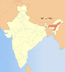
Brahmaputra floods
2012
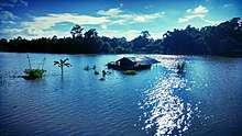
The 2012 Brahmaputra floods were an unprecedented flood event along the Brahmaputra River and its tributaries due to significant monsoon rains in India, Bangladesh and Myanmar. 124 people were killed by the flooding and landslides, and about six million people were displaced. The worst hit area was the state of Assam in India. Flooding significantly affected Kaziranga National Park, where 540 animals died including 13 rhinos.[1]
In September 2011, the Brahmaputra River flowed through braided channels, but a year later, the channels could not be detected in the swollen river. During the monsoon season (June–October), floods are a common occurrence in India. Occasionally, massive flooding causes huge losses to crops, life and property. Deforestation in the Brahmaputra watershed has resulted in increased siltation levels, flash floods, and soil erosion in critical downstream habitat, such as the Kaziranga National Park in middle Assam.[2][3][4]
Helicopters were deployed to drop food supplies to nearly 10,000 people in six villages where highway access was cut off by the flooding, about 550km west of Gauhati, the capital of Assam.
2013
2013 Assam floods were floods in the Indian state of Assam which were triggered by heavy rainfall at the end of June in neighboring Arunachal Pradesh state through Brahmaputra river and its tributaries.[5] These flood submerged 12 districts out of 27 in the state where more than 100,000 people affected.[6][7] The flood also affected Kaziranga National Park and Pobitora Wildlife Sanctuary where many animals have moved on to higher ground to save themselves from the flood.[8] The floods also affected some of the northern districts of Bangladesh where 100,000 people are suffering from a scarcity of food and pure drinking water.[9]
Flood report
According to Assam State Disaster Management Authority's flood report as of 13 July 2013 totally 12 districts out of the 27 districts in the state were affected. The districts are Bongaigaon, Chirang, Dhemaji, Golaghat, Jorhat, Kamrup, Karimganj, Lakhimpur, Morigaon, Nagaon, Sivasagar and Tinsukia. In which 396 villages affected and around 7000 hectares of agricultural land were destroyed. Many roads and bridges were washed away cutting all road links to rest of the state.[10] Eight relief camps have been set up in Dhemaji and Chirang districts where about 3,000 people have been given shelter. The flood victims claimed there were no river embankments at various places or those breached by earlier floods were not repaired.[11]
2015
2015 Assam floods were floods in the Indian state of Assam which were triggered by heavy rainfall at the end of August in neighbouring Arunachal Pradesh state through Brahmaputra river and its tributaries. The floods are reported to have caused the deaths of 42 people and numerous landslides, road blockages and affected 1.65 million people in 21 districts.[12] Flooding affected 2,100 villages and destroyed standing crops across an area of 180,000 hectares (440,000 acres).[12][13][14][15] In the Dhubri district alone, more than 400 villages are now almost impossible to reach making it difficult to send aid to the suffering civilians.[16] However, this is not the first time the Assam state has experienced destructive flooding; the region is possibly India's most flood-prone state and has experienced at least 12 major floods since 1950.[17] Although always prone to floods, the frequency of disastrous floods was increased in the area after the 1950 Assam-Tibet earthquake, also referred to as the "1950 Great Earthquake".[17]
2016
The 2016 Assam floods were caused by large rains over the Indian state of Assam in July 2016. The flooding had affected 1.8 million people, and flooded the Kaziranga National Park.[18] As of 1 August 2016, 28 people had been killed as a result of the flooding starting 17 July, according to a report by the State Disaster Management Authority.[19]
The north-eastern states of India saw heavy rainfalls in July 2016. The state of Assam faced around 60% more rains than it received in July 2015.[20] The rainfall resulted in flooding of various rivers and on 5 July the Brahmaputra River had crossed its danger mark level in the seven districts of Lakhimpur, Dhemaji, Nagaon, Jorhat, Golaghat, Morigaon and Biswanath.[21]
The floods have affected more than 1.6 million human lives, and people choose to abandon their households and livestock, and escape with help of homemade rafts. Mobile phone networks, along with power transmission, have been hampered in many regions of the state.[18] Around 200,000 hectares (490,000 acres) of farming land was affected by the floods.[19] The Assam Branch Indian Tea Association (ABITA) has estimated a 21-30% crop loss of Assam tea. The state of Assam had produced 631 million kg of tea in a year
Wild life
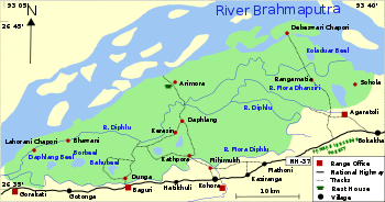
The floods have affected the Pobitora Wildlife Sanctuary[21] and the Kaziranga National Park, a World Heritage Site. As of 2 August 2016, around 300 wild animals have been reported to have drowned, while around 81 percent of the Kaziranga National Park was under water. This includes 21 great one-horned rhinoceroses (Rhinoceros unicornis) and about 219 Indian hog deer (Hyelaphus porcinus).[22][23] The park officially reported deaths of "11 wild boar, nine swamp deer, six sambar, three buffalo, two hog badger, one porcupine and one python" in the time span of 25 July to 31 July.[23]
Officers and local people rescued 100 wild animals, including 9 rhinoceroses.[24] These were taken for treatment at the Centre for Wildlife Rehabilitation and Conservation (CWRC) located within Kaziranga.[23]
Rescue work
About 300 makeshift camps were erected to rehabilitate people displaced by the flooding.[18] Various schools were used as relief camps. National Disaster Response Force took up the relief works.[19] An NGO named "Save the Children" worked for the rehabilitation of children and their families in the three districts of Dhemaji, Lakhimpur and Majuli.[25] Seven public-sector oil companies Oil and Natural Gas Corporation, Indian Oil Corporation, Oil India Limited, Bharat Petroleum Corporation Limited, Hindustan Petroleum Corporation Limited, Gas Authority of India Limited, and Numaligarh Refinery Limited donated a total of ₹15 crore (US$2.1 million) towards Chief Minister’s Relief Fund.[26]
2017
The 2017 Northeast India floods were caused by overflowing of Brahmaputra river in the state of Assam in July 2017 affecting four Indian states: Assam, Arunachal Pradesh, Nagaland and Manipur.[27][28] As of 14 July, 2017, at least 85 people were dead[29] as a result of the flooding and 4 lac people have been affected and 500,000 have been homeless.[30] Nearly 60 animals, mostly deer and wild boars, perished in the floods.[31]
The flood-affected 15 districts of Assam state that includes Lakhimpur, Jorhat, Golaghat, Sivasagar, Cachar, Dhemaji, Karimganj, Sonitpur, Hojai, Biswanath, Majuli, Barpeta, Chirang, Nagaon and Nalbari.[32] It has also inundated large tracts of Kaziranga National Park, Pobitora Wildlife Sanctuary and Nameri National Park.[33]
Rescue work
The state government of Assam set up 128 relief camps under the surveillance of Assam Chief Minister Sarbananda Sonowal for people displaced, and has made arrangements for drinking water, food and medical teams and rescue goods. 154 people died due to drowning, electrocution and diseases caused due to water contamination. Government has provided health and medical facilities in the state.[34]
References
- ↑ "Northeast India floods kill 121, displace 6 mn". Associated Press. Retrieved 8 July 2012.
- ↑ Das, D.C. 2000. Agricultural Landuse and Productivity Pattern in Lower Brahmaputra valley (1970-71 and 1994-95). Ph.D. Thesis, Department of Geography, North Eastern Hill University, Shillong.
- ↑ Mipun, B.S. 1989. Impact of Migrants and Agricultural Changes in the Lower Brahmaputra Valley : A Case Study of Darrang District. Unpublished Ph.D. Thesis, Department of Geography, North Eastern Hill University, Shillong.
- ↑ Shrivastava, R.J. and Heinen, J.T. 2005. "Migration and Home Gardens in the Brahmaputra Valley, Assam, India". Journal of Ecological Anthropology 9: 20-34.
- ↑ Bhaumik, Subir. "BBC News — India floods: Thousands flee homes in Assam". Bbc. Retrieved 11 July 2013.
- ↑ PTI (8 July 2013). "Assam flood situation worsens, PM speaks to Gogoi". The Times of India. Retrieved 11 July 2013.
- ↑ "Assam floods affect 1.1 lakh people in 11 district". Zee News. Retrieved 11 July 2013.
- ↑ "Floodwaters enter Kaziranga as Brahmaputra rises". The Times of India. 10 July 2013. Retrieved 11 July 2013.
- ↑ "Flood situation worsens in northern district". Dhaka Tribune. 11 July 2013. Retrieved 12 July 2013.
- ↑ "Flood report" (PDF). sdmassam.nic.in. Government of Assam. 12 July 2013.
- ↑ "Assam Floods".
- 1 2 "Assam Floods Update: 42 lives claimed so far". Skymet Weather Services. September 8, 2015. Retrieved 2015-09-24.
- ↑ "Over 1.5 million people hit by floods in Assam". Reuters. September 7, 2015. Retrieved September 27, 2015.
- ↑ "Assam floods: Four more dead, toll rises to 24". The Indian Express. September 3, 2015. Retrieved September 27, 2015.
- ↑ "Assam Flood Kill 4, Over 2,000 Villages Still Under Water". NDTV. September 6, 2015. Retrieved September 27, 2015.
- ↑ Pandey, Alok. "Days Without Food, No Relief, Say Locals in Villages Ravaged by Assam Floods". NDTV.
- 1 2 Bhaumik, Subir. "Forgotten floods: Why India can't afford to ignore Assam". BBC.
- 1 2 3 Doshi, Vidhi (27 July 2016). "Flooding in India affects 1.6m people and submerges national park". The Guardian. Retrieved 2 August 2016.
- 1 2 3 Debasree Purkayastha (1 August 2016). "28 dead in Assam floods in two weeks no problems in guwahati". The Hindu. Retrieved 2 August 2016.
- ↑ Supratim Dey (2 August 2016). "Bad weather makes Assam tea output to nosedive in July, industry worried". Business Standard. Retrieved 3 August 2016.
- 1 2 "Assam floods: 90,000 affected, Brahmaputra above danger mark". Indian Express. 5 July 2016. Retrieved 3 August 2016.
- ↑ PTI (2 August 2016). "Over 300 animals killed in Assam floods in Kaziranga". The Times of India. Retrieved 3 August 2016.
- 1 2 3 Samudra Gupta Kashyap (2 August 2016). "Assam floods: 218 animals including 17 rhinos, 166 hog deer dead in Kaziranga". Indian Express. Retrieved 2 August 2016.
- ↑ "Assam Flood: 200 Animals Drown To Death In Kaziranga National Park". The Huffington Post. Assam. 1 August 2016. Retrieved 2 August 2016.
- ↑ "'Save the children' NGO to help children in flood-hit Assam". Indian Express. 2 August 2016. Retrieved 2 August 2016.
- ↑ PTI (3 August 2016). "Oil firms donate Rs 15 crore". The Hindu. Guwahati. Retrieved 3 August 2016.
- ↑ Choudhury, Ratandip (July 6, 2017). "13 Killed, 850 Villages Under Water As Assam Floods Worsen". NDTV.
- ↑ "Assam flood situation worsens, over 4 lakh people affected". The Hindu. July 5, 2017.
- ↑ "85 dead, 58 districts affected: Centre says damage due to floods in northeast 'unprecedented'". Times of India. Retrieved 13 July 2017.
- ↑ "Extreme floods in India kill 28 people and leave 500,000 homeless". The Metro UK. Retrieved 10 July 2017.
- ↑ "Scores killed in India floods and landslides". Al Jazeera. Retrieved 15 July 2017.
- ↑ "Floods in Assam worsen Assam: Floods leave over 39 thousand people homeless". DNA India. July 7, 2017.
- ↑ Kalita, Prabin (Jul 5, 2017). "Assam floods: 4 lakh people affected, over 41,000 in relief camps". The Times of India.
- ↑ "Assam Floods Continue To Leave People Homeless, 39,000 Have Lost Their Homes So Far". Indiatimes.com. July 7, 2017.