Mesocyclone
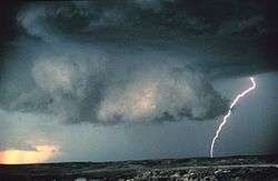
A mesocyclone is a vortex of air within a convective storm.[1] It is air that rises and rotates around a vertical axis, usually in the same direction as low pressure systems in a given hemisphere. They are most often cyclonic, that is, associated with a localized low-pressure region within a severe thunderstorm. Such thunderstorms can feature strong surface winds and severe hail. Mesocyclones often occur together with updrafts in supercells, within which tornadoes may form at the interchange with certain downdrafts.
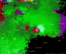
Mesocyclones are localized, approximately 2 km (1.2 mi) to 10 km (6.2 mi) in diameter within strong thunderstorms.[1] Thunderstorms containing persistent mesocyclones are supercell thunderstorms. Mesocyclones occur on the "mesoscale" from a few kilometers to hundreds of kilometers. Doppler radar is used to identify mesocyclones. A mesovortex is a similar but typically smaller and weaker rotational feature associated with squall lines.
Formation
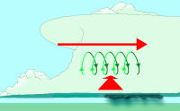
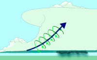
Mesocyclones form when strong changes of wind speed and/or direction with height ("wind shear") sets parts of the lower part of the atmosphere spinning in invisible tube-like rolls. The convective updraft of a thunderstorm then draw up this spinning air, tilting the rolls' orientation upward (from parallel to the ground to perpendicular) and causing the entire updraft to rotate as a vertical column.[2]
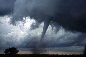
As the updraft rotates and ingests cooler moister air from the forward flank downdraft (FFD), it may form a wall cloud, a spinning layer of clouds lowered from ambient storm cloud base under the mid-level mesocyclone. The wall cloud tends to form closer to the center of the mesocyclone. As it descends, a funnel cloud may form near its center. This is the first visible stage of tornadogenesis.

Identification

The best way to detect and verify the presence of a mesocyclone is by Doppler weather radar. Nearby high values of opposite sign within velocity data are how they are detected.[3] Thus the word mesocyclone is associated with weather radar terminology. Mesocyclones are most often identified in the right-rear flank of supercell thunderstorms and squall lines, and may be distinguished by a hook echo rotation signature on a weather radar map. Visual cues such as a rotating wall cloud or tornado may also hint at the presence of a mesocyclone. This is why the term has entered into wider usage in connection with rotating features in severe storms.
Tornado formation
Tornado formation is not completely understood, but often occurs in one of two ways.[4][5]
In the first method, two conditions must be satisfied.[6] One, a horizontal spinning effect must form on the Earth's surface. This usually originates in sudden changes in wind direction or speed, known as wind shear. Two, a thundercloud, or occasionally a cumulus cloud, must be present. During a thunderstorm, updrafts are occasionally powerful enough to lift the horizontal spinning row of air upwards, turning it into a vertical air column. This vertical air column then becomes the basic structure for the tornado. Tornadoes that form in this way are often weak and generally last less than 10 minutes.[6]
The second method occurs during a supercell thunderstorm, in updrafts within the storm. When winds intensify, the force released can cause the updrafts to rotate. This rotating updraft is known as a mesocyclone.[7] For a tornado to form in this manner, a rear-flank downdraft enters the center of the mesocyclone from the back. Cold air, being denser than warm air is able to penetrate through the updraft. The combination of the updraft and downdraft completes the development of a tornado. Tornadoes that form in this method are often violent and can last over an hour.[6]
Mesoscale convective vortex
A mesoscale convective vortex (MCV), also known as a mesoscale vorticity center or Neddy eddy,[8] is a mesocyclone within an mesoscale convective system (MCS) that pulls winds into a circling pattern, or vortex, at the mid levels of the troposphere and is normally associated with anticyclonic outflow aloft. With a core only 30 to 60 miles (48 to 97 km) wide and 1 to 3 miles (1.6 to 4.8 km) deep, an MCV is often overlooked in standard weather maps. MCVs can persist for up to two days after its parent mesoscale convective system has dissipated.[8] The orphaned MCV can become the seed of the next thunderstorm outbreak. An MCV that moves into tropical waters, such as the Gulf of Mexico, can serve as the nucleus for a tropical storm or hurricane. MCVs can produce very large wind storms; sometimes winds can reach over 100 miles per hour (160 km/h). The May 2009 Southern Midwest Derecho was an extreme progressive derecho and mesoscale convective vortex event that struck southeastern Kansas, southern Missouri, and southwestern Illinois on May 8, 2009.
References
| Wikimedia Commons has media related to Mesocyclone diagrams. |
- 1 2 Glossary of Meteorology (June 2000). "Mesocyclone". American Meteorological Society. Archived from the original on 2006-07-09. Retrieved 2006-12-07.
- ↑ University of Illinois. Vertical Wind Shear Retrieved on 2006-10-21.
- ↑ Glossary of Meteorology (June 2000). "Mesocyclone signature". American Meteorological Society. Archived from the original on 2011-05-14. Retrieved 2010-02-01.
- ↑ "Severe Weather 101: Tornado Basics". NOAA National Severe Storms Laboratory. Retrieved October 2, 2018.
- ↑ Edwards, Roger (April 19, 2018). "The Online Tornado FAQ". NOAA Storm Prediction Center. Retrieved October 2, 2018.
- 1 2 3 National Oceanic and Atmospheric Administration (September 1992). "tornadoes...Nature's Most Violent Storms". A Preparedness Guide. Retrieved 2008-08-03.
- ↑ Thinkquest (October 2003). "Tornado Formation". Oracle Corporation. Archived from the original on 2008-04-21. Retrieved 2009-08-03.
- 1 2 Cooperative Institute for Meteorological Satellite Studies (2004-01-22). "08 July 1997 -- Mesoscale Convective Complex decays,revealing a Mesoscale Vorticity Center". University of Wisconsin-Madison. Retrieved 2010-02-01.