Šmarjeta
| Šmarjeta | |
|---|---|
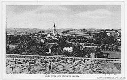 Postcard of Šmarjeta | |
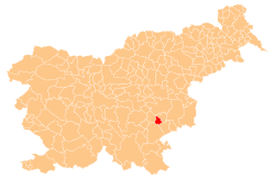
 Šmarjeta Location in Slovenia | |
| Coordinates: 45°53′12.78″N 15°15′3.07″E / 45.8868833°N 15.2508528°ECoordinates: 45°53′12.78″N 15°15′3.07″E / 45.8868833°N 15.2508528°E | |
| Country |
|
| Traditional region | Lower Carniola |
| Statistical region | Southeast Slovenia |
| Municipality | Šmarješke Toplice |
| Area | |
| • Total | 1.58 km2 (0.61 sq mi) |
| Elevation | 189.8 m (622.7 ft) |
| Population (2002) | |
| • Total | 288 |
| [1] | |
Šmarjeta (pronounced [ʃmaˈɾjeːta]; German: Sankt Margarethen[2]) is a village in the Municipality of Šmarješke Toplice in southeastern Slovenia. The area is part of the historical region of Lower Carniola. The municipality is now included in the Southeast Slovenia Statistical Region.[3] The village includes the hamlet of Dolenja Vas (Slovene: Dolenja vas, German: Unterdorf[2]), formerly an independent village.
The local parish church from which the settlement gets its name is dedicated to Saint Margaret (Slovene: sveta Marjeta) and belongs to the Roman Catholic Diocese of Novo Mesto. It was built between 1910 and 1927 on the site of an earlier building.[4]
References
- ↑ Statistical Office of the Republic of Slovenia
- 1 2 Leksikon občin kraljestev in dežel zastopanih v državnem zboru, vol. 6: Kranjsko. 1906. Vienna: C. Kr. Dvorna in Državna Tiskarna, p. 82.
- ↑ Šmarješke Toplice municipal site
- ↑ "EŠD 2535". Registry of Immovable Cultural Heritage (in Slovenian). Ministry of Culture of the Republic of Slovenia. Retrieved 23 May 2011.
External links

- Šmarjeta at Geopedia
| Settlements | Administrative centre: Šmarješke Toplice
|  | ||||
|---|---|---|---|---|---|---|
| Landmarks |
| |||||
This article is issued from
Wikipedia.
The text is licensed under Creative Commons - Attribution - Sharealike.
Additional terms may apply for the media files.