Ōmishima Island, Ehime
| Native name: 大三島 Ōmishima | |
|---|---|
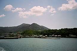 Miyaura port | |
 Ōmishima Island Location in Japan | |
| Geography | |
| Location | Seto Inland Sea |
| Coordinates | 34°14′39″N 133°00′35″E / 34.244139°N 133.009627°ECoordinates: 34°14′39″N 133°00′35″E / 34.244139°N 133.009627°E |
| Area | 64.54 km2 (24.92 sq mi) |
| Length | 12.8 km (7.95 mi) |
| Width | 6.2 km (3.85 mi) |
| Coastline | 88.8 km (55.18 mi) |
| Highest elevation | 437 m (1,434 ft) |
| Highest point | Washigatozan |
| Administration | |
|
Japan | |
| Prefecture | Ehime |
| city | Imabari |
| Demographics | |
| Population | 23398 (1947) |
| Pop. density | 363 /km2 (940 /sq mi) |
| Ethnic groups | Japanese |
Ōmishima Island (大三島 Ōmishima) is the westernmost and largest island in Geiyo Islands chain accommodating Nishiseto Expressway connecting Honshu and Shikoku islands. Its coasts are washed by Seto Inland Sea. The island's highest peak is Washigatozan (鷲ヶ頭山) 437 m (1,434 ft) high.
Geography
Ōmishima is kidney-shaped and together with Ōsakikamijima on the west encloses the calm bay of Utena, where primary seaport of Miyaura is located. The island`s Utena dam reservoir is the primary freshwater source for Ōmishima itself and nearby Hakata.
History
- 1541 - Tsuruhime fights Ōuchi Yoshitaka fleet
- 1874 - post office established
- 1979 - Ōmishima bridge connecting to Ehime Prefecture complete
- 1991 - Tatara Bridge connecting to Hiroshima Prefecture complete
- 16 January 2005 - the towns (including Ōmishima, Ehime) and villages of the island were merged into city of Imabari, Ehime
Transportation
Ōmishima is connected to the mainland of Honshu and Shikoku islands by bridges of Nishiseto Expressway (Shimanami Kaidō). Also, ferry is available to Ōsakikamijima, Okamura Island and Ōkunoshima (Rabbit Island). Ōmishima Island is served by the national Route 317.
Attractions
- The salt factory[1]
- Historical and marine museum[2]
- Ōyamazumi Shrine
- Toyo Ito Museum of Architecture, Imabari
- The entire Ōmishima Island is designated as a National Place of Scenic Beauty
Notable residents
- Shozo Fujita - historian
- Tsuruhime - priestess and warlord
External links
References
- This article incorporates material from Japanese Wikipedia pages 大三島 and 大三島町, accessed 13 September 2017
| Wikimedia Commons has media related to Ōmishima. |