Zonsverduistering van 26 december 2019
De ringvormige zonsverduistering van 26 december 2019 trok meest over zee, maar was zichtbaar op of in deze 12 (ei)landen : Saoedi-Arabië, Qatar, Verenigde Arabische Emiraten, Oman, India, Sri Lanka, Sumatra, West-Maleisië, Singapore, Kalimantan, Oost-Maleisië en de Filipijnen. [1][2]
Zonsverduistering van 26 december 2019
| ||||
 | ||||
Animatie van zonsverduistering op 26 december 2019 | ||||
| Zonsverduistering | ||||
| Datum, tijd en waarneming | ||||
| Datum | 26 december 2019 | |||
| Zichtgebied | Saoedi-Arabië, Qatar, Verenigde Arabische Emiraten, Oman, India, Sri Lanka, Sumatra, West-Maleisië, Singapore, Kalimantan, Oost-Maleisië en de Filipijnen | |||
| Kerngegevens | ||||
| Type | Ringvormig | |||
| Lijst van zonsverduisteringen | ||||
| ||||
Lengte
Maximum
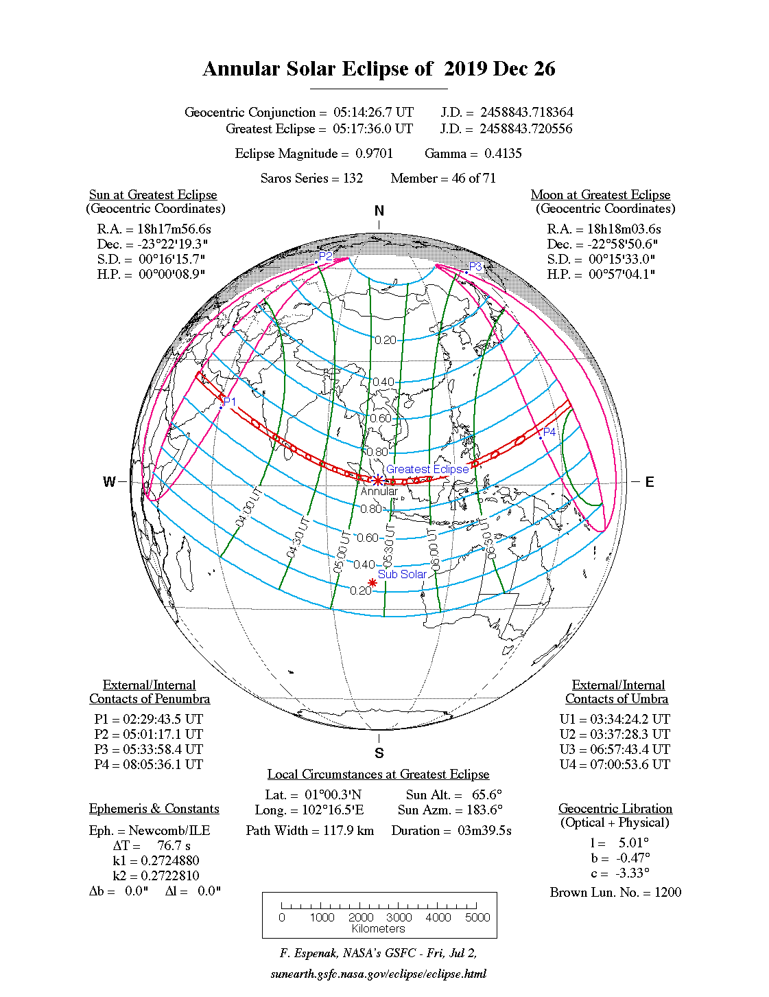
Het punt met maximale ringvormigheid bevond zich op zee vlak voor het eiland Pulau Pedang dat tot Sumatra behoort, en duurde 5m18,5s.
Limieten
| Fenomeen | Code | Tijdstip UTC |
|---|---|---|
| Eerste contact bijschaduw | P1 | 02:29:43.5 |
| Eerste contact kernschaduw | U1 | 03:34:24.2 |
| Kernschaduw compleet vanaf | U2 | 03:37:28.3 |
| Bijschaduw compleet vanaf | P2 | 05:01:17.1 |
| Maximum eclips | GE | 05:17:36.0 |
| Bijschaduw compleet t/m | P3 | 05:33:58.4 |
| Kernschaduw compleet t/m | U3 | 06:57:43.4 |
| Laatste contact kernschaduw | U4 | 07:00:53.6 |
| Laatste contact bijschaduw | P4 | 08:05:36.1 |
Zichtbaarheid
Gebieden
|
Midden-Oosten
|
India en Sri Lanka
|
Indonesië en omgeving
|
Externe links
- NASA Google map van deze verduistering
- NASA overzicht van alle verduisteringen
Bronnen, noten en/of referenties
|
This article is issued from
Wikipedia.
The text is licensed under Creative
Commons - Attribution - Sharealike.
Additional terms may apply for the media files.