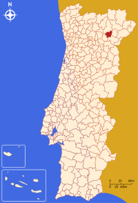
Vila Flor (Portugal)
Vila Flor is een gemeente in het Portugese district Bragança. De gemeente heeft een totale oppervlakte van 266 km2 en telde 7913 inwoners in 2001.
| Gemeente in Portugal | |||
| |||
 | |||
| Situering | |||
| District | Bragança | ||
| Coördinaten | 41°18'NB, 7°9'WL | ||
| Algemeen | |||
| Oppervlakte | 266 km² | ||
| Inwoners (31 december 20051) | 7.688 (29,7 inw./km²) | ||
| |||


Plaatsen in de gemeente
- Assares
- Benlhevai
- Candoso
- Carvalho de Egas
- Freixiel
- Lodões
- Mourão
- Nabo
- Róios
- Samões
- Sampaio
- Santa Comba de Vilariça
- Seixo de Manhoses
- Trindade
- Vale de Torno
- Vale Frechoso
- Vila Flor
- Vilarinho das Azenhas
- Vilas Boas
| Gemeenten in het district Bragança | |
|---|---|
|
Alfândega da Fé · Bragança · Carrazeda de Ansiães · Freixo de Espada à Cinta · Macedo de Cavaleiros · Miranda do Douro · Mirandela · Mogadouro · Torre de Moncorvo · Vila Flor · Vimioso · Vinhais | |
This article is issued from
Wikipedia.
The text is licensed under Creative
Commons - Attribution - Sharealike.
Additional terms may apply for the media files.