South Holland (Lincolnshire)
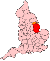
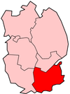
South Holland is een Engels district in het shire-graafschap (non-metropolitan county OF county) Lincolnshire en telt 94.000 inwoners. De oppervlakte bedraagt 751 km². Hoofdplaats is Spalding.
| Niet-metropolitaans district in Engeland | |||
  | |||
| Situering | |||
| Land | Engeland | ||
| County | Lincolnshire | ||
| Regio | East Midlands | ||
| Coördinaten | 52°45'NB, 0°9'WL | ||
| Algemeen | |||
| Oppervlakte | 750,9042[1] km² | ||
| Inwoners (2018[2]) | 93980 (125 inw./km²) | ||
| ONS-code | E07000140 | ||
| |||
Het district ligt in het vlakke, moerasachtige en agrarische gebied The Fens en grenst aan het estuarium The Wash.
Van de bevolking is 21,7% ouder dan 65 jaar. De werkloosheid bedraagt 2,2% van de beroepsbevolking (cijfers volkstelling 2001).
Civil parishes in district South Holland
Cowbit, Crowland, Deeping St Nicholas, Donington, Fleet, Gedney, Gedney Hill, Gosberton, Holbeach, Little Sutton, Long Sutton, Lutton, Moulton, Pinchbeck, Quadring, Surfleet, Sutton Bridge, Sutton St Edmund, Sutton St James, Tydd St Mary, Weston, Whaplode.
Bronnen, noten en/of referenties
|
This article is issued from
Wikipedia.
The text is licensed under Creative
Commons - Attribution - Sharealike.
Additional terms may apply for the media files.