Satterthwaite
Satterthwaite is een civil parish in het bestuurlijke gebied South Lakeland, in het Engelse graafschap Cumbria met 215 inwoners.
| Zie de categorie Satterthwaite van Wikimedia Commons voor mediabestanden over dit onderwerp. |
Above Derwent · Aikton · Ainstable · Aldingham · Allhallows · Allonby · Alston Moor · Angerton · Appleby-in-Westmorland · Arlecdon and Frizington · Arnside · Arthuret · Asby · Askam and Ireleth · Askerton · Askham · Aspatria · Bampton · Barbon · Barton · Bassenthwaite · Beaumont · Beckermet · Beetham · Bewaldeth and Snittlegarth · Bewcastle · Blawith and Subberthwaite · Blennerhasset and Torpenhow · Blindbothel · Blindcrake · Bolton · Boltons · Bootle · Borrowdale · Bothel and Threapland · Bowness-on-Solway · Brampton · Bridekirk · Brigham · Bromfield · Brough · Brough Sowerby · Brougham · Broughton · Broughton East · Broughton Moor · Broughton West · Burgh by Sands · Burtholme · Burton-in-Kendal · Buttermere · Camerton · Carlatton · Carlatton and Cumrew · Cartmel Fell · Casterton · Castle Carrock · Castle Sowerby · Catterlen · Claife · Cleator Moor · Cliburn · Clifton · Cockermouth · Colby · Colton · Coniston · Crackenthorpe · Crook · Crosby Garrett · Crosby Ravensworth · Crosscanonby · Crosthwaite and Lyth · Culgaith · Cummersdale · Cumrew · Cumwhitton · Dacre · Dalston · Dalton Town with Newton · Dean · Dearham · Dent · Distington · Docker · Drigg and Carleton · Dufton · Dundraw · Dunnerdale with Seathwaite · Egremont · Egton with Newland · Embleton · Ennerdale and Kinniside · Eskdale · Farlam · Fawcett Forest · Firbank · Garsdale · Geltsdale · Gilcrux · Glassonby · Gosforth · Grange-over-Sands · Grayrigg · Great Clifton · Great Salkeld · Great Strickland · Greystoke · Haile · Hartley · Haverthwaite · Hawkshead · Hayton · Hayton and Mealo · Helbeck · Helsington · Hesket · Hethersgill · Heversham · Hincaster · Hoff · Holme · Holme Abbey · Holme East Waver · Holme Low · Holme St Cuthbert · Hugill · Hunsonby · Hutton · Hutton Roof · Ireby and Uldale · Irthington · Irton with Santon · Kaber · Kendal · Kentmere · Keswick · Kingmoor · King's Meaburn · Kingwater · Kirkandrews · Kirkbampton · Kirkbride · Kirkby Ireleth · Kirkby Lonsdale · Kirkby Stephen · Kirkby Thore · Kirklinton Middle · Kirkoswald · Lakes · Lambrigg · Lamplugh · Langwathby · Lazonby · Levens · Lindal and Marton · Little Clifton · Little Strickland · Long Marton · Longsleddale · Lorton · Lowca · Lower Allithwaite · Lower Holker · Loweswater · Lowick · Lowside Quarter · Lowther · Lupton · Mallerstang · Mansergh · Mansriggs · Martindale · Maryport · Matterdale · Meathop and Ulpha · Middleton · Midgeholme · Milburn · Millom · Millom Without · Milnthorpe · Moresby · Morland · Muncaster · Mungrisdale · Murton · Musgrave · Nateby · Natland · Nether Denton · Nether Staveley · New Hutton · Newbiggin · Newby · Nicholforest · Old Hutton and Holmescales · Ormside · Orton (Carlisle) · Orton (Eden) · Osmotherley · Oughterside and Allerby · Ousby · Over Staveley · Papcastle · Parton · Patterdale · Pennington · Plumbland · Ponsonby · Preston Patrick · Preston Richard · Ravenstonedale · Rockcliffe · Satterthwaite · Scaleby · Scalthwaiterigg · Seascale · Seaton · Sebergham · Sedbergh · Sedgwick · Setmurthy · Shap · Shap Rural · Silloth · Skelsmergh · Skelton · Skelwith · Sleagill · Sockbridge and Tirril · Solport · Soulby · St Bees · St Bridget Beckermet · St Cuthbert Without · St John's Castlerigg and Wythburn · St John Beckermet · Stainmore · Stainton · Stanwix Rural · Stapleton · Staveley-in-Cartmel · Strickland Ketel · Strickland Roger · Tebay · Temple Sowerby · Threlkeld · Thrimby · Thursby · Torver · Ulpha · Ulverston · Underbarrow and Bradleyfield · Underskiddaw · Upper Allithwaite · Upper Denton · Urswick · Waberthwaite · Waitby · Walton · Warcop · Wasdale · Waterhead · Waverton · Weddicar · Westlinton · Westnewton · Westward · Wetheral · Wharton · Whicham · Whinfell · Whitwell and Selside · Wigton · Windermere · Winscales · Winton · Witherslack · Woodside · Workington · Wythop · Yanwath and Eamont Bridge
Geplaatst op: 11-9-2010 |
Dit artikel is een beginnetje over landen & volken. U wordt uitgenodigd om op bewerken te klikken om uw kennis aan dit artikel toe te voegen. |
| Civil parish in Engeland | |||
 | |||
| Situering | |||
| Regio | North West England | ||
| Graafschap | Cumbria | ||
| District | South Lakeland | ||
| Coördinaten | 54° 19' NB, 3° 1' WL | ||
| Algemeen | |||
| Oppervlakte | 29,2350 km² | ||
| Inwoners (2011) | 215 (7,4 inw./km²) | ||
| Overig | |||
| Grid code | SD3371092317 | ||
| ONS-code | E04002644 | ||
| Foto's | |||
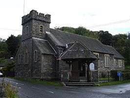 | |||
| All Saints' Parish Church | |||
| |||