Outagamie County
Outagamie County is een van de 72 county's in de Amerikaanse staat Wisconsin.
| County in de Verenigde Staten | |||
 | |||
| Situering | |||
| Staat | Wisconsin | ||
| Tijdzone | Central Standard Time (UTC−6) | ||
| Coördinaten | 44°24'36"NB, 88°27'36"WL | ||
| Algemeen | |||
| Oppervlakte | 1.669 km² | ||
| - land | 1.658 km² | ||
| - water | 11 km² | ||
| Inwoners (2000) | 160.971 (97 inw./km²) | ||
| Overig | |||
| Zetel | Appleton | ||
| FIPS-code | 55087 | ||
| Opgericht | 1851 | ||
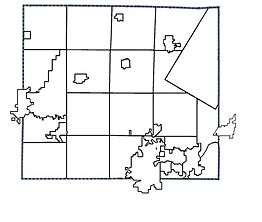
| Detailkaart | |||
 | |||
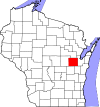
| Overzichtskaart van Outagamie County | |||
| Foto's | |||
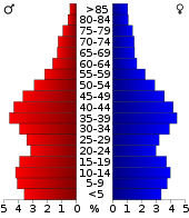 Bevolkingspiramide Outagamie County | |||
| Statistieken volkstelling Outagamie County | |||
| |||
De county heeft een landoppervlakte van 1.658 km² en telt 160.971 inwoners (volkstelling 2000). De hoofdplaats is Appleton.
Bevolkingsontwikkeling
| Historische inwonertallen | |||
|---|---|---|---|
| Jaar | Inwoners | % ± | |
| 1900 | 46.247 | ||
| 1910 | 49.102 | 6,2% | |
| 1920 | 55.113 | 12,2% | |
| 1930 | 62.790 | 13,9% | |
| 1940 | 70.032 | 11,5% | |
| 1950 | 81.722 | 16,7% | |
| 1960 | 101.794 | 24,6% | |
| 1970 | 119.356 | 17,3% | |
| 1980 | 128.799 | 7,9% | |
| 1990 | 140.510 | 9,1% | |
| 2000 | 160.971 | 14,6% | |
| Bron: (en) Historical Decennial Census Population | |||

Outagamie County Courthouse
This article is issued from
Wikipedia.
The text is licensed under Creative
Commons - Attribution - Sharealike.
Additional terms may apply for the media files.