Ashland County (Wisconsin)
Ashland County is een van de 72 county's in de Amerikaanse staat Wisconsin.
| County in de Verenigde Staten | |||
 | |||
| Situering | |||
| Staat | Wisconsin | ||
| Tijdzone | Central Standard Time (UTC−6) | ||
| Coördinaten | 46°42'36"NB, 90°33'36"WL | ||
| Algemeen | |||
| Oppervlakte | 5.940 km² | ||
| - land | 2.703 km² | ||
| - water | 3.237 km² | ||
| Inwoners (2000) | 16.866 (6 inw./km²) | ||
| Overig | |||
| Zetel | Ashland | ||
| FIPS-code | 55003 | ||
| Opgericht | 1860 | ||
| Foto's | |||
 Bevolkingspiramide Ashland County | |||
| Statistieken volkstelling Ashland County | |||
| |||
De county heeft een landoppervlakte van 2.703 km² en telt 16.866 inwoners (volkstelling 2000). De hoofdplaats is Ashland.
Bevolkingsontwikkeling
| Historische inwonertallen | |||
|---|---|---|---|
| Jaar | Inwoners | % ± | |
| 1900 | 20.176 | ||
| 1910 | 21.965 | 8,9% | |
| 1920 | 24.538 | 11,7% | |
| 1930 | 21.054 | −14,2% | |
| 1940 | 21.801 | 3,5% | |
| 1950 | 19.461 | −10,7% | |
| 1960 | 17.375 | −10,7% | |
| 1970 | 16.743 | −3,6% | |
| 1980 | 16.783 | 0,2% | |
| 1990 | 16.307 | −2,8% | |
| 2000 | 16.866 | 3,4% | |
| Bron: (en) Historical Decennial Census Population | |||
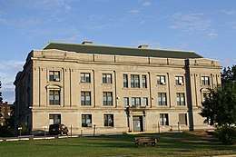
Ashland County Courthouse
This article is issued from
Wikipedia.
The text is licensed under Creative
Commons - Attribution - Sharealike.
Additional terms may apply for the media files.