Nowata County
Nowata County is een van de 77 county's in de Amerikaanse staat Oklahoma.
| County in de Verenigde Staten | |||
 | |||
| Situering | |||
| Staat | Oklahoma | ||
| Tijdzone | Central Standard Time (UTC−6) | ||
| Coördinaten | 36°47'24"NB, 95°37'12"WL | ||
| Algemeen | |||
| Oppervlakte | 1.504 km² | ||
| - land | 1.463 km² | ||
| - water | 41 km² | ||
| Inwoners (2000) | 10.569 (7 inw./km²) | ||
| Overig | |||
| Zetel | Nowata | ||
| FIPS-code | 40105 | ||
| Opgericht | 1907 | ||
| Foto's | |||
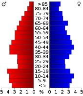 Bevolkingspiramide Nowata County | |||
| Statistieken volkstelling Nowata County | |||
| |||
De county heeft een landoppervlakte van 1.463 km² en telt 10.569 inwoners (volkstelling 2000). De hoofdplaats is Nowata.
This article is issued from
Wikipedia.
The text is licensed under Creative
Commons - Attribution - Sharealike.
Additional terms may apply for the media files.