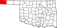
Cimarron County
Cimarron County is een van de 77 county's in de Amerikaanse staat Oklahoma, gelegen in het uiterste westen van de staat (Oklahoma Panhandle). Cimarron is de enige county in de V.S. die grenst aan vier staten (Colorado, Kansas, New Mexico en Texas).
| County in de Verenigde Staten | |||
 | |||
| Situering | |||
| Staat | Oklahoma | ||
| Tijdzone | Central Standard Time (UTC−6) | ||
| Coördinaten | 36°44'24"NB, 102°31'12"WL | ||
| Algemeen | |||
| Oppervlakte | 4.769 km² | ||
| - land | 4.753 km² | ||
| - water | 16 km² | ||
| Inwoners (2000) | 3.148 (1 inw./km²) | ||
| Overig | |||
| Zetel | Boise City | ||
| FIPS-code | 40025 | ||
| Opgericht | 1907 | ||
| Foto's | |||
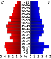 Bevolkingspiramide Cimarron County | |||
| Statistieken volkstelling Cimarron County | |||
| |||
De 412 in Cimarron
De county heeft een landoppervlakte van 4.753 km² en telt 3.148 inwoners (volkstelling 2000). De hoofdplaats is Boise City.
Het hoogste punt van Oklahoma (1.516 m) ligt in Cimarron en is onderdeel van de Black Mesa, een tafelberg.
| Zie de categorie Cimarron County, Oklahoma van Wikimedia Commons voor mediabestanden over dit onderwerp. |
This article is issued from
Wikipedia.
The text is licensed under Creative
Commons - Attribution - Sharealike.
Additional terms may apply for the media files.