Montmorin (Hautes-Alpes)
Montmorin is een plaats en voormalige gemeente in het Franse departement Hautes-Alpes in de regio Provence-Alpes-Côte d'Azur. Antonaves fuseerde op 1 januari 2017 met Bruis en Sainte-Marie tot de commune nouvelle Valdoule, die deel uitmaakt van het arrondissement Gap.
Gemeente in Frankrijk | |||
 | |||
| Situering | |||
| Regio | Provence-Alpes-Côte d'Azur | ||
| Departement | Hautes-Alpes (5) | ||
| Arrondissement | Gap | ||
| Kanton | Serres | ||
| Coördinaten | 44° 27′ NB, 5° 33′ OL | ||
| Algemeen | |||
| Oppervlakte | 29,0 km² | ||
| Inwoners (1 jan. 2011) | 91 (3,1 inw./km²) | ||
| Hoogte | 719 - 1564 m | ||
| Overig | |||
| Postcode | 05150 | ||
| INSEE-code | 05088 | ||
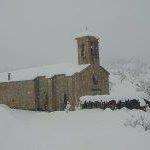
Foto's | |||
 | |||
| |||
Geografie
De oppervlakte van Montmorin bedraagt 29,0 km², de bevolkingsdichtheid is dus 3,1 inwoners per km².
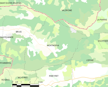
De onderstaande kaart toont de ligging van Montmorin (Hautes-Alpes) met de belangrijkste infrastructuur en aangrenzende gemeenten.
 |
Demografie
Onderstaande figuur toont het verloop van het inwonertal (bron: INSEE-tellingen).
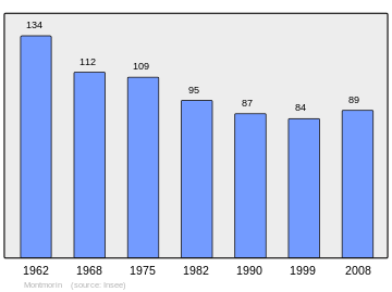 Grafiek inwonertal gemeente |
Externe links
This article is issued from
Wikipedia.
The text is licensed under Creative
Commons - Attribution - Sharealike.
Additional terms may apply for the media files.