Minster-in-Thanet
Minster-in-Thanet, ook Minster, is een civil parish in het bestuurlijke gebied Thanet, in het Engelse graafschap Kent.
Geplaatst op: 10-07-2007 |
Dit artikel is een beginnetje over landen & volken. U wordt uitgenodigd om op bewerken te klikken om uw kennis aan dit artikel toe te voegen. |
| Civil parish in Engeland | |||
 | |||
| Situering | |||
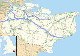
| Regio | South East England | ||
| Graafschap | Kent | ||
| District | Thanet | ||
| Coördinaten | 51° 20' NB, 1° 18' OL | ||
| Algemeen | |||
| Oppervlakte | 19,5442 km² | ||
| Inwoners (2011) | 3569 (183 inw./km²) | ||
| Overig | |||
| Postcode(s) | CT12 | ||
| Netnummer(s) | 01843 | ||
| Grid code | TR305645 | ||
| Post town | Ramsgate | ||
| ONS-code | E04005084 | ||
| Foto's | |||
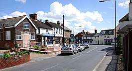 | |||
| "The Square", Minster-in-Thanet | |||
| |||
This article is issued from
Wikipedia.
The text is licensed under Creative
Commons - Attribution - Sharealike.
Additional terms may apply for the media files.