Bury (district)
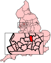
Bury (Metropolitan Borough of Bury) is een district in het stedelijk graafschap (metropolitan county) Greater Manchester en telt 190.000 inwoners. De oppervlakte bedraagt 99 km².
| Metropolitaans district in Engeland | |||
| |||
 | |||
| Situering | |||
| Land | Engeland | ||
| County | Greater Manchester | ||
| Regio | North West England | ||
| Coördinaten | 53°35'34"NB, 2°17'53"WL | ||
| Algemeen | |||
| Oppervlakte | 99,4601[1] km² | ||
| Inwoners (2018[2]) | 190108 (1911 inw./km²) | ||
| ONS-code | E08000002 | ||
| |||

Van de bevolking is 14,8% ouder dan 65 jaar. De werkloosheid bedraagt 2,8% van de beroepsbevolking (cijfers volkstelling 2001).
Plaatsen in district Bury
- Bury (hoofdplaats)
- Whitefield
Bronnen, noten en/of referenties
|
This article is issued from
Wikipedia.
The text is licensed under Creative
Commons - Attribution - Sharealike.
Additional terms may apply for the media files.