Mecklenburg County (North Carolina)
Mecklenburg County is een county in de Amerikaanse staat North Carolina.
| County in de Verenigde Staten | |||
 | |||
| Situering | |||
| Staat | North Carolina | ||
| Tijdzone | Eastern Standard Time (UTC−5) | ||
| Coördinaten | 35°15'0"NB, 80°49'48"WL | ||
| Algemeen | |||
| Oppervlakte | 1.415 km² | ||
| - land | 1.363 km² | ||
| - water | 52 km² | ||
| Inwoners (2000) | 695.454 (510 inw./km²) | ||
| Overig | |||
| Zetel | Charlotte | ||
| FIPS-code | 37119 | ||
| Opgericht | 1762 | ||
| Detailkaart | |||
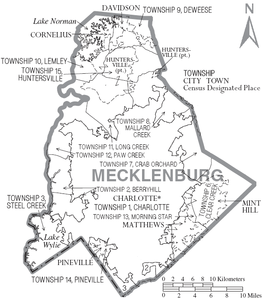 | |||
| Overzichtskaart van Mecklenburg County | |||
| Foto's | |||
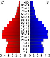 Bevolkingspiramide Mecklenburg County | |||
| Statistieken volkstelling Mecklenburg County | |||
| |||
De county heeft een landoppervlakte van 1.363 km² en telt 695.454 inwoners (volkstelling 2000). De hoofdplaats is Charlotte.
Mecklenburg County verklaarde zich middels de Mecklenburg Declaration of Independence, op 20 mei 1775, aan het begin van de Amerikaanse Onafhankelijkheidsoorlog, als eerste county van North Carolina onafhankelijk van het Verenigd Koninkrijk. Daarmee speelt Mecklenburg County een belangrijke rol in de geschiedenis van North Carolina, die onder meer tot uitdrukking wordt gebracht door de plaatsing van de datum van 20 mei 1775 op de vlag van North Carolina.
Bevolkingsontwikkeling
| Historische inwonertallen | |||
|---|---|---|---|
| Jaar | Inwoners | % ± | |
| 1900 | 55.268 | ||
| 1910 | 67.031 | 21,3% | |
| 1920 | 80.695 | 20,4% | |
| 1930 | 127.971 | 58,6% | |
| 1940 | 151.826 | 18,6% | |
| 1950 | 197.052 | 29,8% | |
| 1960 | 272.111 | 38,1% | |
| 1970 | 354.656 | 30,3% | |
| 1980 | 404.270 | 14,0% | |
| 1990 | 511.433 | 26,5% | |
| 2000 | 695.454 | 36,0% | |
| Bron: (en) Historical Decennial Census Population | |||
This article is issued from
Wikipedia.
The text is licensed under Creative
Commons - Attribution - Sharealike.
Additional terms may apply for the media files.