Lijst van gemeentelijke monumenten in Olst-Wijhe
De gemeente Olst-Wijhe heeft 75 gemeentelijke monumenten, hieronder een overzicht. Zie ook de rijksmonumenten in Olst-Wijhe.
Boskamp
De plaats Boskamp kent 1 gemeentelijk monument:
| Object | Bouwjaar | Architect | Locatie | Coördinaten | Nr. | Afbeelding |
|---|---|---|---|---|---|---|
| Boerderij | 1850 | Dingshofweg 3 | 52° 20' 5" NB, 6° 8' 27" OL | 1773/WN001 | Upload foto |
Den Nul
De plaats Den Nul kent 3 gemeentelijke monumenten:
| Object | Bouwjaar | Architect | Locatie | Coördinaten | Nr. | Afbeelding |
|---|---|---|---|---|---|---|
| Dwarshuisboerderij | 1850 | Holstweg 44 | 52° 21' 22" NB, 6° 7' 13" OL | 1773/WN002 | Upload foto | |
| Boerderij | 1850 | Koetsweg 2 | 52° 21' 56" NB, 6° 6' 47" OL | 1773/WN003 | Upload foto | |
| Boerderij | 1850 | Koetsweg 4 | 52° 21' 59" NB, 6° 6' 39" OL | 1773/WN004 | Upload foto |
Olst
De plaats Olst kent 47 gemeentelijke monumenten:
| Object | Bouwjaar | Architect | Locatie | Coördinaten | Nr. | Afbeelding |
|---|---|---|---|---|---|---|
| Boerderij | 1746 | Bockhorsterstraat 3 | 52° 18' 15" NB, 6° 7' 24" OL | 1773/WN005 | Upload foto | |
| Villa | Boxbergerweg 47 | 52° 19' 17" NB, 6° 10' 22" OL | 1773/WN006 | Upload foto | ||
| Landhuis Huize Wijnbergen | 1750 | Diepenveenseweg 20 | 52° 18' 33" NB, 6° 8' 22" OL | 1773/WN007 | 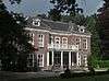 | |
| Voormalig koetshuis | Diepenveenseweg 22 | 52° 18' 31" NB, 6° 8' 21" OL | 1773/WN008 | Upload foto | ||
| Boerderij | 1880 | Diepenveenseweg 24a | 52° 18' 25" NB, 6° 8' 20" OL | 1773/WN009 | Upload foto | |
| Kapel | 1900 | Diepenveenseweg 26 | 52° 18' 24" NB, 6° 8' 21" OL | 1773/WN010 | 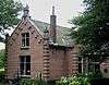 | |
| Woonhuis | 1833 | Hendrik Droststraat 20a | 52° 20' 18" NB, 6° 6' 25" OL | 1773/WN011 | Upload foto | |
| Woonhuis/winkel | 1910 | Hendrik Droststraat 45 | 52° 20' 19" NB, 6° 6' 32" OL | 1773/WN012 | Upload foto | |
| Boerderij | 1900 | Eikelhofweg 4 | 52° 19' 38" NB, 6° 7' 40" OL | 1773/WN013 | Upload foto | |
| Boerderij De Hoogenkamp | 1840 | Eikelhofweg 18 | 52° 19' 11" NB, 6° 9' 40" OL | 1773/WN014 | Upload foto | |
| Villa De Eekwal | 1936 | Eikelhofweg 41 | 52° 19' 13" NB, 6° 9' 40" OL | 1773/WN015 | Upload foto | |
| Waterschapshuis | 1873 | Aaldert Geertsstraat 4 | 52° 20' 17" NB, 6° 6' 35" OL | 1773/WN016 | 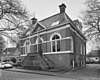 | |
| Woonhuis | 1860 | Aaldert Geertsstraat 9 | 52° 20' 18" NB, 6° 6' 36" OL | 1773/WN017 | Upload foto | |
| Woonhuis | 1865 | Aaldert Geertsstraat 11 | 52° 20' 17" NB, 6° 6' 37" OL | 1773/WN018 | Upload foto | |
| Villa Olsterhof | 1850 | Aaldert Geertsstraat 16 | 52° 20' 16" NB, 6° 6' 37" OL | 1773/WN019 |  | |
| Woonhuis | 1870 | Aaldert Geertsstraat 18 | 52° 20' 16" NB, 6° 6' 38" OL | 1773/WN020 | 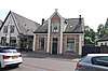 | |
| Bakhuisje | Aaldert Geertsstraat 19 | 52° 20' 17" NB, 6° 6' 39" OL | 1773/WN021 | Upload foto | ||
| Woonhuis | 1900 | Aaldert Geertsstraat 23 | 52° 20' 16" NB, 6° 6' 40" OL | 1773/WN022 |  | |
| Woonhuis | 1880 | Aaldert Geertsstraat 25 | 52° 20' 16" NB, 6° 6' 41" OL | 1773/WN023 | Upload foto | |
| Postkantoor 't Olde Postkantoor | 1920 | Aaldert Geertsstraat 39 | 52° 20' 16" NB, 6° 6' 44" OL | 1773/WN024 | Upload foto | |
| Schoorsteen Olba-schoorsteen | Aaldert Geertsstraat 42 | 52° 20' 14" NB, 6° 6' 43" OL | 1773/WN025 |  | ||
| Woonhuis | 1880 | Aaldert Geertsstraat 52 | 52° 20' 15" NB, 6° 6' 47" OL | 1773/WN026 | Upload foto | |
| Woonhuis | 1905 | Aaldert Geertsstraat 56 | 52° 20' 14" NB, 6° 6' 49" OL | 1773/WN027 | Upload foto | |
| Boerderij | 1890 | Hoenloseweg 3 | 52° 19' 35" NB, 6° 7' 46" OL | 1773/WN028 | Upload foto | |
| Fabrikantenvilla | 1903 | Jan Hooglandstraat 2 | 52° 20' 12" NB, 6° 6' 53" OL | 1773/WN029 | Upload foto | |
| Villa | 1880 | Jan Hooglandstraat 22 | 52° 20' 9" NB, 6° 6' 59" OL | 1773/WN030 | Upload foto | |
| Fabrikantenvilla 't Polletje | 1911 | Jan Hooglandstraat 36 | 52° 20' 6" NB, 6° 7' 2" OL | 1773/WN031 | Upload foto | |
| Woonhuis Honk | Kerkplein 13 | 52° 20' 15" NB, 6° 6' 50" OL | 1773/WN032 | Upload foto | ||
| Boerderij Bambelt | 1804 | Ketelgatstraat 13 | 52° 19' 38" NB, 6° 8' 59" OL | 1773/WN033 | Upload foto | |
| Villa Groenendaal | 1917 | Kleistraat 7 | 52° 20' 19" NB, 6° 7' 22" OL | 1773/WN034 | Upload foto | |
| Boerderij | 1924 | Koekoeksweg 3 | 52° 20' 5" NB, 6° 7' 10" OL | 1773/WN035 | Upload foto | |
| Kapel | Molenpad 20 | 52° 23' 10" NB, 6° 8' 2" OL | 1773/WN036 | Upload foto | ||
| Boerderij De Zoogenbrink | 1820 | Molenweg 3 | 52° 19' 4" NB, 6° 8' 51" OL | 1773/WN037 |  | |
| Villa | 1925 | L.H.Pottstraat 6 | 52° 20' 20" NB, 6° 6' 52" OL | 1773/WN038 | Upload foto | |
| Boerderij | 1840 | Puinweg 2 | 52° 19' 7" NB, 6° 7' 8" OL | 1773/WN039 | Upload foto | |
| Ruïne ringovens voormalige steenfabriek Hengforden | 1843 | Rijksstraatweg (ongenummerd) | 52° 18' 55" NB, 6° 6' 1" OL | 1773/WN040 |  | |
| Dijkwoning | Rijksstraatweg 13 | 52° 20' 21" NB, 6° 6' 22" OL | 1773/WN041 | Upload foto | ||
| Gemeentehuis | 1825 | Rijksstraatweg 25/27 | 52° 20' 23" NB, 6° 6' 24" OL | 1773/WN042 | Upload foto | |
| Pakhuis bij molen Bökkers Mölle | Rijksstraatweg 45a | 52° 20' 31" NB, 6° 6' 29" OL | 1773/WN043 |  | ||
| Villa | 1928 | Rozenhof 2 | 52° 20' 20" NB, 6° 6' 51" OL | 1773/WN044 | Upload foto | |
| Voormalig ziekenhuis | 1914 | Rozenhof 3/5 | 52° 20' 19" NB, 6° 6' 49" OL | 1773/WN045 |  | |
| Villa De Lankhorsterkamp | Rozenvoorderdijk 1 | 52° 19' 56" NB, 6° 10' 28" OL | 1773/WN046 | Upload foto | ||
| Boerderij | Scherpenzeelsweg 5/7 | 52° 22' 21" NB, 6° 7' 13" OL | 1773/WN047 | Upload foto | ||
| Woonhuis | Stationsweg 14 | 52° 20' 11" NB, 6° 6' 47" OL | 1773/WN048 | Upload foto | ||
| Woonhuizen | Veerweg 4/6 | 52° 20' 25" NB, 6° 6' 23" OL | 1773/WN049 | Upload foto | ||
| Voormalig veerhuis | Veerweg 24 | 52° 20' 25" NB, 6° 6' 21" OL | 1773/WN050 |  | ||
| Boerderij | Wijheseweg 4 | 52° 21' 56" NB, 6° 7' 46" OL | 1773/WN051 | Upload foto |
Welsum
De plaats Welsum kent 15 gemeentelijke monumenten:
| Object | Bouwjaar | Architect | Locatie | Coördinaten | Nr. | Afbeelding |
|---|---|---|---|---|---|---|
| Langhuisboerderij | 1669 | Arkerstraat 3 | 52° 19' 12" NB, 6° 4' 39" OL | 1773/WN052 | Upload foto | |
| Boerderij | 1842 | Erveweg 4 | 52° 19' 50" NB, 6° 5' 6" OL | 1773/WN053 | Upload foto | |
| Boerderij | Erveweg 8 | 52° 20' 6" NB, 6° 5' 15" OL | 1773/WN054 | Upload foto | ||
| Boerderij Zaailing | 1876 | Erveweg 13 | 52° 20' 42" NB, 6° 4' 49" OL | 1773/WN055 | Upload foto | |
| Boerderij De Hombraak | 1876 | Erveweg 26 | 52° 20' 32" NB, 6° 5' 31" OL | 1773/WN056 | Upload foto | |
| Boerderij | IJsseldijk 10 | 52° 20' 60" NB, 6° 5' 29" OL | 1773/WN057 | Upload foto | ||
| Dijkwoning | 1825 | IJsseldijk 37 | 52° 22' 31" NB, 6° 5' 23" OL | 1773/WN058 | Upload foto | |
| Dijkwoning | IJsseldijk 39 | 52° 22' 32" NB, 6° 5' 25" OL | 1773/WN059 | Upload foto | ||
| Boerderij De Brabantse Wagen | IJsseldijk 51/51a | 52° 20' 1" NB, 6° 5' 29" OL | 1773/WN060 |  | ||
| Dijkwoning | IJsseldijk 97 | 52° 20' 49" NB, 6° 5' 40" OL | 1773/WN061 | Upload foto | ||
| Dwarshuisboerderij | IJsseldijk 101 | 52° 20' 52" NB, 6° 5' 34" OL | 1773/WN062 | Upload foto | ||
| Dwarshuisboerderij Spanjaardshoeve | IJsseldijk 105 | 52° 20' 57" NB, 6° 5' 32" OL | 1773/WN063 | Upload foto | ||
| Dwarshuisboerderij Zielegoed | 1830 | IJsseldijk 107 | 52° 20' 58" NB, 6° 5' 29" OL | 1773/WN064 | Upload foto | |
| Dwarshuisboerderij 't Hemelrijck | 1856 | Kerklaan 2 | 52° 20' 10" NB, 6° 5' 26" OL | 1773/WN065 | Upload foto | |
| Boerderij/woonhuis | Veldweg 1 | 52° 18' 44" NB, 6° 5' 5" OL | 1773/WN066 | Upload foto |
Wesepe
De plaats Wesepe kent 6 gemeentelijke monumenten:
| Object | Bouwjaar | Architect | Locatie | Coördinaten | Nr. | Afbeelding |
|---|---|---|---|---|---|---|
| Boerderij | 1924 | G. J. Kappertweg 2 | 52° 19' 43" NB, 6° 13' 36" OL | 1773/WN067 | Upload foto | |
| Boerderij De Gulle Lach | Ds.E.Kreikenlaan 10 | 52° 19' 46" NB, 6° 12' 58" OL | 1773/WN068 | Upload foto | ||
| Pastorie | 1896 | Ds.E.Kreikenlaan 12 | 52° 19' 47" NB, 6° 13' 9" OL | 1773/WN069 | Upload foto | |
| Boerderij | 1898 | Raalterweg 83 | 52° 20' 13" NB, 6° 12' 29" OL | 1773/WN070 | Upload foto | |
| Landarbeidershuisje Klompsplaatsje | Stapelhaarspad ongen. | 1773/WN071 | Upload foto | |||
| Boerderij | Velsdijk 2 | 52° 20' 11" NB, 6° 12' 27" OL | 1773/WN072 | Upload foto |
Wijhe
De plaats Wijhe kent 3 gemeentelijke monumenten:
| Object | Bouwjaar | Architect | Locatie | Coördinaten | Nr. | Afbeelding |
|---|---|---|---|---|---|---|
| Pakhuis | Kippenmarkt ongen. | 1773/WN073 | Upload foto | |||
| Pakhuis Kippenmarkt | Langstraat 57a | 52° 23' 14" NB, 6° 8' 11" OL | 1773/WN074 | Upload foto | ||
| Boerderij | Spijkerboschpad 5 | 52° 19' 50" NB, 6° 8' 8" OL | 1773/WN075 | Upload foto |
| Zie de categorie Gemeentelijke monumenten in Olst-Wijhe van Wikimedia Commons voor mediabestanden over dit onderwerp. |
Bronnen, noten en/of referenties
|
| Gemeentelijke monumenten in Overijssel | ||
|---|---|---|
|
Almelo · Borne · Dalfsen · Dinkelland · Deventer · Enschede · Haaksbergen · Hardenberg · Hellendoorn · Hengelo · Hof van Twente · Kampen · Losser · Oldenzaal · Olst-Wijhe · Ommen · Raalte · Rijssen-Holten · Staphorst · Steenwijkerland · Twenterand · Wierden · Zwartewaterland · Zwolle | ||
This article is issued from
Wikipedia.
The text is licensed under Creative
Commons - Attribution - Sharealike.
Additional terms may apply for the media files.