Lijst van gemeentelijke monumenten in Hengelo (Overijssel)
De gemeente Hengelo heeft 110 gemeentelijke monumenten, hieronder een overzicht. Zie ook de rijksmonumenten in Hengelo.
| Object | Bouwjaar | Architect | Locatie | Coördinaten | Nr. | Afbeelding |
|---|---|---|---|---|---|---|
| Jachtpaal | Altenavoetpad | 0164/WN001 | Upload foto | |||
| Drieneroord | Anninksweg 109 | 52° 15' 51" NB, 6° 48' 31" OL | 0164/WN002 | Upload foto | ||
| Drieneroord | Anninksweg 111 | 52° 15' 51" NB, 6° 48' 31" OL | 0164/WN003 | Upload foto | ||
| Jachthut | Bartelinkslaantje 21 | 52° 16' 45" NB, 6° 49' 11" OL | 0164/WN004 | Upload foto | ||
| Voormalig Jongerencentrum Radar | Beukweg 92 | 52° 16' 23" NB, 6° 47' 34" OL | 0164/WN005 |  | ||
| Beukweg 94 | 52° 16' 24" NB, 6° 47' 33" OL | 0164/WN006 | Upload foto | |||
| Voormalige kerk / bloedbank | Beukweg 73 | 52° 16' 21" NB, 6° 47' 31" OL | 0164/WN007 | Upload foto | ||
| Woonhuis met garage in Functionalisme stijl | 1925-1927 | W.M. Dudok | Beursstraat 1A | 52° 15' 48" NB, 6° 47' 49" OL | 0164/WN008 | 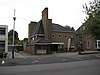 |
| Beursstraat 2 | 52° 15' 47" NB, 6° 47' 45" OL | 0164/WN009 | 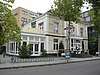 | |||
| Twentsche Bank | Beursstraat 15 | 52° 15' 45" NB, 6° 47' 45" OL | 0164/WN010 | 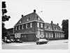 | ||
| Streekziekenhuis Midden-Twente | 1954 | B. J. K. Cramer | Boerhaavelaan 63, 65, 75, 77 | 52° 15' 52" NB, 6° 46' 16" OL | 0164/WN011 | Upload foto |
| De Kasbah | 1973 | P. Blom | Booggang etc | 52° 15' 58" NB, 6° 49' 48" OL | 0164/WN012 | .jpg) |
| Voormalige TCS | Bornsestraat 7 | 52° 16' 9" NB, 6° 47' 27" OL | 0164/WN013 |  | ||
| Breemarsschool | Breemarsweg 270 | 52° 15' 11" NB, 6° 46' 54" OL | 0164/WN014 | Upload foto | ||
| Brinkstraat 5 | 52° 15' 54" NB, 6° 47' 35" OL | 0164/WN015 |  | |||
| Brinkstraat 7 | 52° 15' 54" NB, 6° 47' 35" OL | 0164/WN016 | Upload foto | |||
| Voormalig brouwerijgebouw | Brouwerijstraat 49 | 52° 13' 58" NB, 6° 53' 14" OL | 0164/WN017 | Upload foto | ||
| Burenweg 72 | 52° 17' 7" NB, 6° 45' 6" OL | 0164/WN018 | Upload foto | |||
| Burgemeester Jansenplein 40 | 52° 15' 56" NB, 6° 47' 30" OL | 0164/WN019 | 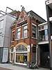 | |||
| Stadhuis | 1958-1963 | Prof. Ir. J.F. Berghoef | Burgemeester Jansenplein 1 | 52° 15' 58" NB, 6° 47' 31" OL | 0164/WN020 | 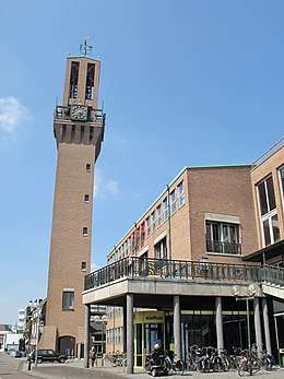 |
| Colensostraat 2 | 52° 16' 3" NB, 6° 47' 59" OL | 0164/WN021 |  | |||
| Colensostraat 4 | 52° 16' 3" NB, 6° 47' 59" OL | 0164/WN022 |  | |||
| Colensostraat 6 | 52° 16' 3" NB, 6° 47' 60" OL | 0164/WN023 |  | |||
| Colensostraat 8 | 52° 16' 3" NB, 6° 48' 0" OL | 0164/WN024 |  | |||
| Colensostraat 10 | 52° 16' 3" NB, 6° 48' 1" OL | 0164/WN025 |  | |||
| Jachtpaal | Deldenerdijk | 0164/WN026 | Upload foto | |||
| Deldenerstraat 36-38 | 52° 16' 0" NB, 6° 47' 17" OL | 0164/WN027 |  | |||
| Gemeentewerken | Deldenerstraat 59 | 52° 15' 55" NB, 6° 47' 15" OL | 0164/WN028 |  | ||
| Deldenerstraat 61 | 52° 15' 57" NB, 6° 47' 12" OL | 0164/WN029 | 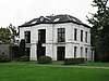 | |||
| Deldenerstraat 65 | 52° 15' 58" NB, 6° 47' 8" OL | 0164/WN030 | Upload foto | |||
| Jachtpaal | Deldenerstraat | 0164/WN031 | Upload foto | |||
| Deldenerstraat 35 t/m 41 | 52° 15' 59" NB, 6° 47' 20" OL | 0164/WN032 | 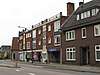 | |||
| Voormalig Hotel de Kroon | Deldenerstraat 62 t/m 68 | 52° 15' 59" NB, 6° 47' 11" OL | 0164/WN033 | 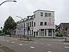 | ||
| Drieneresweg 145 | 52° 15' 21" NB, 6° 50' 5" OL | 0164/WN034 | Upload foto | |||
| Weeshuis | Emmaweg 5 | 52° 15' 51" NB, 6° 47' 17" OL | 0164/WN035 |  | ||
| Enschedesestraat 142 | 52° 15' 40" NB, 6° 48' 12" OL | 0164/WN036 | Upload foto | |||
| Enschedesestraat 244 | 52° 15' 27" NB, 6° 48' 35" OL | 0164/WN037 | Upload foto | |||
| Enschedesestraat 246 | 52° 15' 27" NB, 6° 48' 36" OL | 0164/WN038 | Upload foto | |||
| Enschedesestraat 248 | 52° 15' 27" NB, 6° 48' 36" OL | 0164/WN039 | Upload foto | |||
| Enschedesestraat 250 | 52° 15' 27" NB, 6° 48' 37" OL | 0164/WN040 | Upload foto | |||
| Pakhuis | Enschedesestraat 86 | 52° 15' 47" NB, 6° 47' 55" OL | 0164/WN041 | 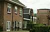 | ||
| Enschedesestraat 14 | 52° 15' 54" NB, 6° 47' 38" OL | 0164/WN042 | 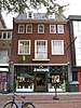 | |||
| Enschedesestraat 16 en 18 | 52° 15' 51" NB, 6° 47' 47" OL | 0164/WN043 | 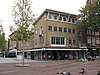 | |||
| Enschedesestraat 45 | 52° 15' 51" NB, 6° 47' 49" OL | 0164/WN044 |  | |||
| Enschedesestraat 47 | 52° 15' 51" NB, 6° 47' 50" OL | 0164/WN045 |  | |||
| 't Kotten | Geurdsweg 4 | 52° 14' 27" NB, 6° 44' 39" OL | 0164/WN046 | Upload foto | ||
| Grundellaan 18 | 52° 15' 42" NB, 6° 48' 24" OL | 0164/WN047 | Upload foto | |||
| Grundellaan 19 | 52° 15' 43" NB, 6° 48' 23" OL | 0164/WN048 | Upload foto | |||
| Grundellaan 23 | 52° 15' 44" NB, 6° 48' 24" OL | 0164/WN049 | Upload foto | |||
| H. Leefsmastraat 191 | 52° 16' 48" NB, 6° 47' 2" OL | 0164/WN050 | Upload foto | |||
| Groot Altena | Haaksbergerstraat 205 | 52° 12' 28" NB, 6° 44' 18" OL | 0164/WN051 | Upload foto | ||
| Heemafstraat 12 | 52° 16' 2" NB, 6° 47' 19" OL | 0164/WN052 |  | |||
| Heemafstraat 14 | 52° 16' 2" NB, 6° 47' 19" OL | 0164/WN053 | 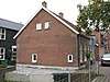 | |||
| Kleuterschool | Hermanstraat 1 | 52° 15' 14" NB, 6° 47' 57" OL | 0164/WN054 | Upload foto | ||
| Horstweg 32 | 52° 15' 40" NB, 6° 45' 49" OL | 0164/WN055 | Upload foto | |||
| Ketelhuis Stork | Industriestraat | 0164/WN056 | Upload foto | |||
| Schoorsteen | Industriestraat | 0164/WN057 | Upload foto | |||
| Industriestraat 35 | 52° 15' 24" NB, 6° 47' 16" OL | 0164/WN058 | Upload foto | |||
| Raphaelkerk | Josef Haydnlaan 66 | 52° 16' 14" NB, 6° 49' 2" OL | 0164/WN059 | 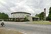 | ||
| Toegangspalen | Landmansweg nabij 37 | 0164/WN060 | Upload foto | |||
| Grolsch Bierhuis | Langelermaatweg 244 | 52° 15' 10" NB, 6° 47' 28" OL | 0164/WN061 | Upload foto | ||
| Langestraat 25 | 52° 15' 57" NB, 6° 47' 27" OL | 0164/WN062 |  | |||
| Langestraat 27 | 52° 15' 57" NB, 6° 47' 26" OL | 0164/WN063 |  | |||
| Fabriekshal Stork Pompen | Lansinkesweg 30 | 52° 15' 42" NB, 6° 47' 7" OL | 0164/WN064 | Upload foto | ||
| De Boender | Loninkvoetpad 20 | 52° 13' 1" NB, 6° 43' 24" OL | 0164/WN065 | Upload foto | ||
| Telgenflat | Markt 9,15, 101, 203 t/m 212, 301 t/m 312, 406, 408, 410, 502, 512 | 52° 15' 49" NB, 6° 47' 34" OL | 0164/WN066 |  | ||
| Coöperatieve samenwerking (Cosa) | 1949 | Markt 2 | 52° 15' 52" NB, 6° 47' 36" OL | 0164/WN067 | 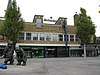 | |
| 1950 | W. R. van Couwelaar | Marktstraat 1 t/m 5a; Brinkstraat 16-16a | 52° 15' 52" NB, 6° 47' 33" OL | 0164/WN068 |  | |
| Bischoff | ca. 1950 | H. T. Zwiers | Markt 1, 1A t/m D, Brinkstraat 7A-7B | 52° 15' 53" NB, 6° 47' 34" OL | 0164/WN069 |  |
| Marskant 72 | 52° 15' 58" NB, 6° 47' 17" OL | 0164/WN070 | 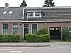 | |||
| Marskant 74 | 52° 15' 58" NB, 6° 47' 17" OL | 0164/WN071 |  | |||
| Marssteeg 22 | 52° 15' 58" NB, 6° 47' 18" OL | 0164/WN072 | 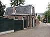 | |||
| Morshoekweg 30 | 52° 15' 9" NB, 6° 49' 56" OL | 0164/WN073 | Upload foto | |||
| Het Annink | Mussenstraat 32 | 52° 15' 56" NB, 6° 48' 27" OL | 0164/WN074 |  | ||
| Nieuwstraat 2 | 52° 15' 52" NB, 6° 47' 41" OL | 0164/WN075 | 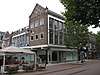 | |||
| Erve Veldhuis | Nijhuisbinnenweg 1 | 52° 15' 4" NB, 6° 43' 44" OL | 0164/WN076 | 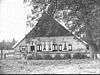 | ||
| Erve Giesberts= | Nijhuisbinnenweg 14 | 52° 14' 54" NB, 6° 44' 46" OL | 0164/WN077 | Upload foto | ||
| Oelersteeg 36 | 52° 14' 31" NB, 6° 44' 56" OL | 0164/WN078 | Upload foto | |||
| Bethlehemkerk | 1934 | A.K. Beudt | Oelerweg 95 | 52° 15' 21" NB, 6° 46' 31" OL | 0164/WN079 | 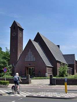 |
| Archeologisch monument | Olde Meulenweg nabij 8 | 0164/WN080 | Upload foto | |||
| Algemene Begraafplaats | Oldenzaalsestraat 349 | 52° 16' 19" NB, 6° 48' 37" OL | 0164/WN081 |  | ||
| Ariënsschool | Oldenzaalsestraat 14 | 52° 16' 3" NB, 6° 47' 44" OL | 0164/WN082 | 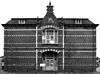 | ||
| Volksbad | Oldenzaalsestraat 18 | 52° 16' 4" NB, 6° 47' 45" OL | 0164/WN083 |  | ||
| Pastorie | Onze Lieve Vrouwestraat 6 | 52° 16' 16" NB, 6° 48' 21" OL | 0164/WN084 | Upload foto | ||
| Klaas aan de Brug | Oude Hengeloseweg 130 | 52° 17' 12" NB, 6° 45' 49" OL | 0164/WN085 | Upload foto | ||
| Oversteweg 2 | 52° 16' 8" NB, 6° 47' 42" OL | 0164/WN086 |  | |||
| 't Neutje | Pastoriestraat 14-16 | 52° 15' 56" NB, 6° 47' 25" OL | 0164/WN087 |  | ||
| Dr. Poolhuis | Pastoriestraat 43 | 52° 15' 57" NB, 6° 47' 22" OL | 0164/WN088 | 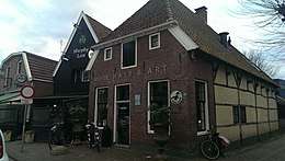 | ||
| Pastoriestraat 45 | 52° 15' 58" NB, 6° 47' 22" OL | 0164/WN089 | 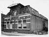 | |||
| Thomassonhuis | Pastoriestraat 51 | 52° 15' 58" NB, 6° 47' 21" OL | 0164/WN090 | 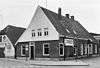 | ||
| Paul Krugerstraat 54 t/m 64 | 52° 16' 4" NB, 6° 47' 57" OL | 0164/WN091 | 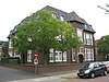 | |||
| Paul Krugerstraat 25 | 52° 15' 57" NB, 6° 47' 59" OL | 0164/WN092 |  | |||
| Paul Krugerstraat 29 | 52° 15' 58" NB, 6° 47' 59" OL | 0164/WN093 |  | |||
| Paul Krugerstraat 27 | 52° 15' 58" NB, 6° 47' 59" OL | 0164/WN094 |  | |||
| Paul Krugerstraat 31 | 52° 15' 58" NB, 6° 47' 59" OL | 0164/WN095 | 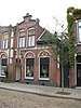 | |||
| Plantsoen inclusief opstallen | Prins Bernhard Plantsoen | 0164/WN096 | Upload foto | |||
| Rotersweg 8 | 52° 12' 44" NB, 6° 44' 9" OL | 0164/WN097 | Upload foto | |||
| Wilbertschool | Ruijsdaelstraat 45 | 52° 16' 38" NB, 6° 47' 5" OL | 0164/WN098 | Upload foto | ||
| Archeologisch monument | Sherwood Rangers | 0164/WN099 | Upload foto | |||
| Sluitersdijk 3 | 52° 14' 39" NB, 6° 43' 38" OL | 0164/WN100 | Upload foto | |||
| Europatunnel | 1959 | Spoorstraat | 52° 15' 43" NB, 6° 47' 32" OL | 0164/WN101 | .jpg) | |
| Stationsgebouw | Stationsplein 1 | 52° 15' 44" NB, 6° 47' 38" OL | 0164/WN102 | 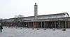 | ||
| Steynstraat 27 | 52° 15' 59" NB, 6° 47' 51" OL | 0164/WN103 |  | |||
| Steynstraat 29 | 52° 16' 27" NB, 6° 47' 19" OL | 0164/WN104 | Upload foto | |||
| Twekkelerplein 26 | 52° 15' 25" NB, 6° 48' 4" OL | 0164/WN105 |  | |||
| Waarbeekschool | Twekkelerweg 86 | 52° 15' 24" NB, 6° 48' 3" OL | 0164/WN106 | |||
| Tribune | Twekkelerweg 311 | 52° 14' 53" NB, 6° 48' 20" OL | 0164/WN107 | Upload foto | ||
| Voormalig sanatorium | Van Alphenstraat 19 | 52° 16' 52" NB, 6° 47' 24" OL | 0164/WN108 | Upload foto | ||
| Voormalige bibliotheek | 1930 | A.K. Beudt | Vondelstraat 2 | 52° 15' 49" NB, 6° 47' 11" OL | 0164/WN109 | 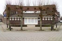 |
| Vm. kantoor Raad van Arbeid | Wolter ten Catestraat 57-59 | 52° 15' 42" NB, 6° 47' 54" OL | 0164/WN110 | Upload foto |
| Zie de categorie Gemeentelijke monumenten in Hengelo, Overijssel van Wikimedia Commons voor mediabestanden over dit onderwerp. |
Bronnen, noten en/of referenties
|
| Gemeentelijke monumenten in Overijssel | ||
|---|---|---|
|
Almelo · Borne · Dalfsen · Dinkelland · Deventer · Enschede · Haaksbergen · Hardenberg · Hellendoorn · Hengelo · Hof van Twente · Kampen · Losser · Oldenzaal · Olst-Wijhe · Ommen · Raalte · Rijssen-Holten · Staphorst · Steenwijkerland · Twenterand · Wierden · Zwartewaterland · Zwolle | ||
This article is issued from
Wikipedia.
The text is licensed under Creative
Commons - Attribution - Sharealike.
Additional terms may apply for the media files.