Le Châtelet (Cher)
Le Châtelet is een gemeente in het Franse departement Cher (regio Centre-Val de Loire) en telt 1139 inwoners (2004). De plaats maakt deel uit van het arrondissement Saint-Amand-Montrond.
Gemeente in Frankrijk | |||
| |||
 | |||
| Situering | |||
| Regio | Centre-Val de Loire | ||
| Departement | Cher (18) | ||
| Arrondissement | Saint-Amand-Montrond | ||
| Kanton | Le Châtelet | ||
| Coördinaten | 46° 38′ NB, 2° 17′ OL | ||
| Algemeen | |||
| Oppervlakte | 32,5 km² | ||
| Inwoners (1 jan. 2011) | 1.131 (34,8 inw./km²) | ||
| Hoogte | 186 - 276 m | ||
| Overig | |||
| Postcode | 18170 | ||
| INSEE-code | 18059 | ||
| |||

Geografie
De oppervlakte van Le Châtelet bedraagt 32,5 km², de bevolkingsdichtheid is 35,0 inwoners per km².
De onderstaande kaart toont de ligging van Le Châtelet (Cher) met de belangrijkste infrastructuur en aangrenzende gemeenten.
 |
Demografie
Onderstaande figuur toont het verloop van het inwonertal (bron: INSEE-tellingen).
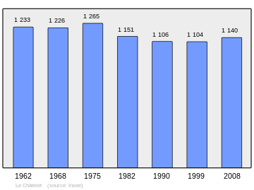 Grafiek inwonertal gemeente |
Externe links
| vorige etappe Saint-Amand-Montrond |
Jakobsweg Via Lemovicensis |
volgende etappe La Châtre |
This article is issued from
Wikipedia.
The text is licensed under Creative
Commons - Attribution - Sharealike.
Additional terms may apply for the media files.