Inverkip
Inverkip (Schots-Gaelisch: Inbhir Chip) is een plaats in de Schotse council Inverclyde. Inverkip ligt 6.4 kilometer ten zuidwesten van Greenock aan de A78. In 2001 waren er in Inverkip ongeveer 1600 inwoners.
| Plaats in Schotland | |||
 | |||
| Situering | |||
| Raadsgebied (council area) | Inverclyde | ||
| Lieutenancy area | Renfrewshire | ||
| Coördinaten | 55° 55' NB, 4° 52' WL | ||
| Algemeen | |||
| Oppervlakte | 0.9 km² | ||
| Inwoners | 1598[1] (1,769.51 inw./km²) | ||
| Grid code | NS205725 | ||
| Overig | |||
| Postcode(s) | PA16 | ||
| Netnummer(s) | 01475 | ||
| Post town | GREENOCK | ||
| Foto's | |||
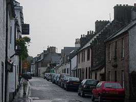 | |||
| Hoofdstraat Inverkip | |||
| |||
Inverkip wordt bediend door een station op de Inverclyde Line.
Geplaatst op: 27-06-2009 |
Dit artikel is een beginnetje over landen & volken. U wordt uitgenodigd om op bewerken te klikken om uw kennis aan dit artikel toe te voegen. |
| Bronnen |
This article is issued from
Wikipedia.
The text is licensed under Creative
Commons - Attribution - Sharealike.
Additional terms may apply for the media files.