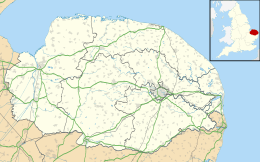
Hunstanton
Hunstanton is een civil parish in het bestuurlijke gebied King's Lynn en West Norfolk, in het Engelse graafschap Norfolk met 1869 inwoners.
 Hunstanton
 Greevegate, Hunstanton
.jpg) Town Sign
Town Sign
Geplaatst op: 14-8-2010 |
Dit artikel is een beginnetje over landen & volken. U wordt uitgenodigd om op bewerken te klikken om uw kennis aan dit artikel toe te voegen. |
| Civil parish in Engeland | |||
 | |||
| Situering | |||
| Regio | East of England | ||
| Graafschap | Norfolk | ||
| District | King's Lynn en West Norfolk | ||
| Coördinaten | 52° 56' NB, 0° 29' OL | ||
| Algemeen | |||
| Oppervlakte | 2,2626 km² | ||
| Inwoners (2011) | 1869 (38 inw./km²) | ||
| Overig | |||
| Postcode(s) | PE36 | ||
| Netnummer(s) | 01485 | ||
| Grid code | TF6740 | ||
| Post town | HUNSTANTON | ||
| ONS-code | E04006325 | ||
| Foto's | |||
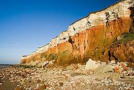 | |||
| Klippen bij Hunstanton | |||
| |||
This article is issued from
Wikipedia.
The text is licensed under Creative
Commons - Attribution - Sharealike.
Additional terms may apply for the media files.