Hrubieszów (gemeente)
De gemeente Hrubieszów is een landgemeente in het Poolse woiwodschap Lublin, in powiat Hrubieszowski.
| Gemeente in Polen | |||
| |||
 | |||
| Situering | |||
| Woiwodschap | Lublin | ||
| Powiat | Powiat Hrubieszowski | ||
| Coördinaten | 50° 49′ NB, 23° 53′ OL | ||
| Gegevens | |||
| Oppervlakte | 259,2 km² | ||
| Inwoners (2004) | 10 958 (42,3 inw./km²) | ||
| Gemeente type | wiejska | ||
| Sołectwo | 36 | ||
| Politiek | |||
| Gemeentezetel | 22-500 Hrubieszów ul. Prusa 8 | ||
| wójt | Jan Mołodecki | ||
| Overig | |||
| Netnummer(s) | 84 | ||
| Kentekenplaat | LHR | ||
| Gemeentecode | 0604042 | ||
| Website | Link | ||
| Detailkaart | |||
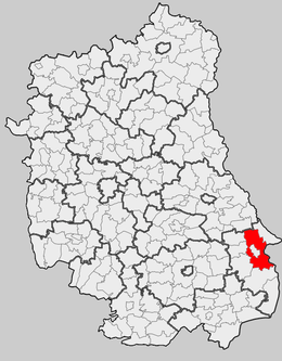 | |||
| Ligging in het woiwodschap | |||
| |||

De zetel van de gemeente is in Hrubieszów.
Op 30 juni 2004 telde de gemeente 10 958 inwoners.
Oppervlakte gegevens
In 2002 bedroeg de totale oppervlakte van gemeente Hrubieszów 259,2 km², waarvan:
De gemeente beslaat 20,42% van de totale oppervlakte van de powiat.
Demografie
| Omschrijving | Totaal | Vrouwen | Mannen | |||
|---|---|---|---|---|---|---|
| eenheid | aantal | % | aantal | % | aantal | % |
| inwoners | 10 958 | 100 | 5462 | 49,8 | 5496 | 50,2 |
| bevolkingsdichtheid (inw./km²) | 42,3 | 21,1 | 21,2 | |||
In 2002 bedroeg het gemiddelde inkomen per inwoner 1096,66 zł.
Administratieve plaatsen (sołectwo)
Annopol, Brodzica, Cichobórz, Czerniczyn, Czumów, Czortowice, Dąbrowa, Dziekanów, Gródek, Husynne, Janki, Kobło, Kosmów, Kozodawy, Kułakowice Pierwsze, Kułakowice Drugie, Kułakowice Trzecie, Masłomęcz, Metelin, Mieniany, Moniatycze, Moniatycze-Kolonia, Moroczyn, Nowosiółki, Obrowiec, Stefankowice, Stefankowice-Kolonia, Szpikołosy, Ślipcze, Świerszczów, Teptiuków, Turkołówka, Ubrodowice-Kolonia, Wolica, Wołajowice.
Plaatsen zonder de status sołectwo Białoskóry, Łotoszyny, Wołynka.
Aangrenzende gemeenten
Białopole, Horodło, Hrubieszów, Mircze, Trzeszczany, Uchanie, Werbkowice. De gemeente grenst aan de Oekraïne.