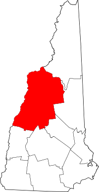
Grafton County
Grafton County is een county in de Amerikaanse staat New Hampshire.
| County in de Verenigde Staten | |||
 | |||
| Situering | |||
| Staat | New Hampshire | ||
| Coördinaten | 43°53'45,848"NB, 71°53'40,668"WL | ||
| Algemeen | |||
| Oppervlakte | 4.533 km² | ||
| - land | 4.438 km² | ||
| - water | 95 km² | ||
| Inwoners (2000) | 81.743 (18 inw./km²) | ||
| Overig | |||
| Zetel | Haverhill | ||
| FIPS-code | 33009 | ||
| Opgericht | 1769 | ||
| Foto's | |||
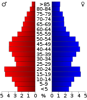 Bevolkingspiramide Grafton County | |||
| Statistieken volkstelling Grafton County | |||
| |||
De county heeft een landoppervlakte van 4.438 km² en telt 81.743 inwoners (volkstelling 2000). De hoofdplaats is Haverhill.
Lakes Region
Grafton County valt binnen de Lakes Region. Binnen de county liggen onder andere de meren Newfound Lake, Profile Lake en Lake Tarleton.
Bevolkingsontwikkeling
| Historische inwonertallen | |||
|---|---|---|---|
| Jaar | Inwoners | % ± | |
| 1900 | 40.844 | ||
| 1910 | 41.652 | 2,0% | |
| 1920 | 40.572 | −2,6% | |
| 1930 | 42.816 | 5,5% | |
| 1940 | 44.645 | 4,3% | |
| 1950 | 47.923 | 7,3% | |
| 1960 | 48.857 | 1,9% | |
| 1970 | 54.914 | 12,4% | |
| 1980 | 65.806 | 19,8% | |
| 1990 | 74.929 | 13,9% | |
| 2000 | 81.743 | 9,1% | |
| Bron: (en) Historical Decennial Census Population | |||
This article is issued from
Wikipedia.
The text is licensed under Creative
Commons - Attribution - Sharealike.
Additional terms may apply for the media files.