East Staffordshire
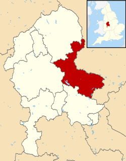
East Staffordshire is een Engels district in het shire-graafschap (non-metropolitan county OF county) Staffordshire en telt 119.000 inwoners. De oppervlakte bedraagt 387 km².
| Niet-metropolitaans district in Engeland | |||
 | |||
| Situering | |||
| Land | Engeland | ||
| County | Staffordshire | ||
| Regio | West Midlands | ||
| Coördinaten | 52°48'29"NB, 1°38'45"WL | ||
| Algemeen | |||
| Oppervlakte | 386,9575[1] km² | ||
| Inwoners (2018[2]) | 118574 (306 inw./km²) | ||
| ONS-code | E07000193 | ||
| |||
Van de bevolking is 15,7% ouder dan 65 jaar. De werkloosheid bedraagt 3,1% van de beroepsbevolking (cijfers volkstelling 2001).
Civil parishes in district East Staffordshire
Abbots Bromley, Anglesey, Anslow, Barton-under-Needwood, Blithfield, Branston, Brizlincote, Burton, Croxden, Denstone, Draycott in the Clay, Dunstall, Ellastone, Hanbury, Hoar Cross, Horninglow and Eton, Kingstone, Leigh, Marchington, Mayfield, Newborough, Okeover, Outwoods, Ramshorn, Rocester, Rolleston on Dove, Shobnall, Stanton, Stapenhill, Stretton, Tatenhill, Tutbury, Uttoxeter, Uttoxeter Rural, Winshill, Wootton, Wychnor, Yoxall.
Bronnen, noten en/of referenties
|
This article is issued from
Wikipedia.
The text is licensed under Creative
Commons - Attribution - Sharealike.
Additional terms may apply for the media files.