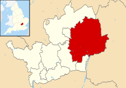
East Hertfordshire
East Hertfordshire is een Engels district in het shire-graafschap (non-metropolitan county OF county) Hertfordshire en telt 148.000 inwoners. De oppervlakte bedraagt 476 km².
| Niet-metropolitaans district in Engeland | |||
 | |||
| Situering | |||
| Land | Engeland | ||
| County | Hertfordshire | ||
| Regio | East of England | ||
| Coördinaten | 51°54'NB, 0°0'OL | ||
| Algemeen | |||
| Oppervlakte | 475,6696[1] km² | ||
| Inwoners (2018[2]) | 148105 (311 inw./km²) | ||
| ONS-code | E07000242 | ||
| |||
Van de bevolking is 13,7% ouder dan 65 jaar. De werkloosheid bedraagt 1,6% van de beroepsbevolking (cijfers volkstelling 2001).
Civil parishes in district East Hertfordshire
Albury, Anstey, Ardeley, Aspenden, Aston, Bayford, Bengeo Rural, Benington, Bishop's Stortford, Bramfield, Braughing, Brent Pelham, Brickendon Liberty, Buckland, Buntingford, Cottered, Datchworth, Eastwick, Furneux Pelham, Gilston, Great Amwell, Great Munden, Hertford, Hertford Heath, Hertingfordbury, High Wych, Hormead, Hunsdon, Little Berkhamsted, Little Hadham, Little Munden, Meesden, Much Hadham, Sacombe, Sawbridgeworth, Standon, Stanstead Abbots, Stanstead St Margarets, Stapleford, Stocking Pelham, Tewin, Thorley, Thundridge, Walkern, Ware, Wareside, Watton-at-Stone, Westmill, Widford, Wyddial.
Bronnen, noten en/of referenties
|