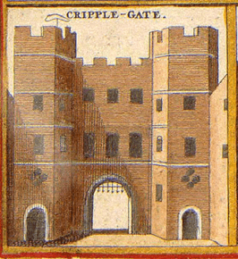
Cripplegate
Cripplegate was een stadspoort in de London Wall. Het is ook een gebied (ward) in het Londense bestuurlijke gebied City of London, in de regio Groot-Londen.
| Wijk in Londen in Engeland | |||
 | |||
| Situering | |||
| Regio | London | ||
| District | City of London | ||
| Borough | City of London | ||
| Coördinaten | 51° 31' NB, 0° 5' WL | ||
| Algemeen | |||
| Oppervlakte | 0,1272[1] km² | ||
| Overig | |||
| Postcode(s) | EC3 | ||
| Netnummer(s) | 020 | ||
| Grid code | TQ327811 | ||
| Post town | LONDON | ||
| Foto's | |||
 | |||
| |||
| Bronnen, noten en/of referenties |
Geplaatst op: 14-07-2007 |
Dit artikel is een beginnetje over landen & volken. U wordt uitgenodigd om op bewerken te klikken om uw kennis aan dit artikel toe te voegen. |
This article is issued from
Wikipedia.
The text is licensed under Creative
Commons - Attribution - Sharealike.
Additional terms may apply for the media files.