Coulterville (Californië)
Coulterville is een dorpje in Mariposa County, in de Amerikaanse staat Californië. Het is een voormalig mijnstadje in de westelijke uitlopers van het Sierra Nevada-gebergte, waar in 1848 de Californische goldrush uitbrak. Coulterville is erkend als California Historical Landmark #332 en een deel van het dorpscentrum staat op het National Register of Historic Places als een historic district. Coulterville ligt op de kruising van State Route 49 en SR 132, langs waar veel toeristen naar het oostelijk gelegen Yosemite National Park reizen. Coulterville is een census-designated place zonder eigen bestuur en telde 210 permanente inwoners in 2010.
Plaats in de Verenigde Staten | |||
 | |||
 Locatie van Californië in de VS | |||
| Situering | |||
| County | Mariposa County | ||
| Type plaats | Census-designated place | ||
| Staat | Californië | ||
| Coördinaten | 37° 43′ NB, 120° 12′ WL | ||
| Algemeen | |||
| Oppervlakte | 10,919 km² | ||
| - land | 10,917 km² | ||
| - water | 0,002 km² | ||
| Inwoners (2010) | 201 | ||
| Hoogte | 518 m | ||
| Overig | |||
| ZIP-code(s) | 95311 | ||
| Foto's | |||
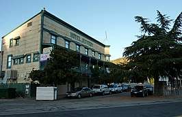 | |||
| Hotel Jeffery, uit 1851, in het historische district van Coulterville. | |||
| |||
This article is issued from
Wikipedia.
The text is licensed under Creative
Commons - Attribution - Sharealike.
Additional terms may apply for the media files.