Coleraine (district)
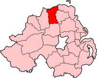
Coleraine is een voormalig district (met borough status) in Noord-Ierland. Het is sinds 2015 deel van het district Causeway Coast and Glens. Coleraine telde in 2007 56.800 inwoners. De oppervlakte bedraagt 486 km², de bevolkingsdichtheid is 116,9 inwoners per km². Van de bevolking is 69,4% protestant en 27,2% katholiek.
| Bestuurlijke indeling van het Verenigd Koninkrijk: Voormalige districten van Noord-Ierland (1973-2015) | |
|---|---|
|
Antrim · Ards · Armagh · Ballymena · Ballymoney · Banbridge · Belfast · Carrickfergus · Castlereagh · Coleraine · Cookstown · Craigavon · Derry (Londonderry) · Down · Dungannon en South Tyrone · Fermanagh · Larne · Limavady · Lisburn · Magherafelt · Moyle · Newry and Mourne · Newtownabbey · North Down · Omagh · Strabane | |
Voormalig district in Noord-Ierland | |||
 | |||
| Coördinaten | 55°7'55"NB, 6°40'5"WL | ||
| Algemeen | |||
| Oppervlakte | 486 km² | ||
| Inwoners (2007) | 56.800 | ||
| Hoofdstad | Coleraine | ||
| |||
This article is issued from
Wikipedia.
The text is licensed under Creative
Commons - Attribution - Sharealike.
Additional terms may apply for the media files.