Campo do Brito
Campo do Brito is een gemeente in de Braziliaanse deelstaat Sergipe. De gemeente telt 16.745 inwoners (schatting 2009).
Gemeente in Brazilië | |||
| |||
 | |||
| Situering | |||
| Regio | Noordoost | ||
| Staat | Sergipe | ||
| Mesoregio | Agreste Sergipano | ||
| Microregio | Agreste de Itabaiana | ||
| Coördinaten | 10° 44′ ZB, 37° 30′ WL | ||
| Algemeen | |||
| Oppervlakte | 200,8 km² | ||
| Inwoners (2009) | 16.745 (82,03 inw./km²) | ||
| Hoogte | 208 m | ||
| Politiek | |||
| Burgemeester | Manoel de Souza | ||
| Gesticht | 29 oktober 1912 | ||
| Overig | |||
| Tijdzone | UTC−3 | ||
| HDI | 0,661 | ||
| Website | campodobrito.se.gov.br | ||
Detailkaart | |||
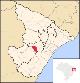 | |||
| Locatie van Campo do Brito in de staat Sergipe | |||
| |||


De gemeente grenst aan Itabaiana, Areia Branca, Itaporanga d'Ajuda, Lagarto, São Domingos en Macambira.
| Bronnen, noten en/of referenties |
This article is issued from
Wikipedia.
The text is licensed under Creative
Commons - Attribution - Sharealike.
Additional terms may apply for the media files.