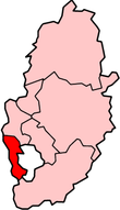
Broxtowe
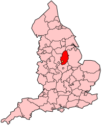
Broxtowe is een Engels district in het shire-graafschap (non-metropolitan county OF county) Nottinghamshire en telt 107.570 inwoners. De oppervlakte bedraagt 80 km².
| Niet-metropolitaans district in Engeland | |||
  | |||
| Situering | |||
| Land | Engeland | ||
| County | Nottinghamshire | ||
| Regio | East Midlands | ||
| Coördinaten | 52°57'0"NB, 1°16'12"WL | ||
| Algemeen | |||
| Oppervlakte | 80,0989[1] km² | ||
| Inwoners (2001) | 107.570 (1343 inw./km²) | ||
| ONS-code | E07000172 | ||
| |||
Van de bevolking is 16,4% ouder dan 65 jaar. De werkloosheid bedraagt 2,6% van de beroepsbevolking (cijfers volkstelling 2001).
Civil parishes in district Broxtowe
Awsworth, Brinsley, Cossall, Eastwood, Greasley, Kimberley, Nuthall, Stapleford, Strelley, Trowell.
| Bronnen, noten en/of referenties |
This article is issued from
Wikipedia.
The text is licensed under Creative
Commons - Attribution - Sharealike.
Additional terms may apply for the media files.