Bayou La Batre
Bayou La Batre is een plaats (city) in de Amerikaanse staat Alabama, en valt bestuurlijk gezien onder Mobile County.
Plaats in de Verenigde Staten | |||
 | |||
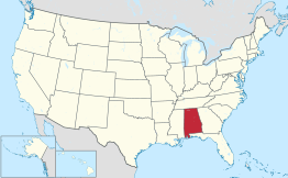 Locatie van Alabama in de VS | |||
| Situering | |||
| County | Mobile County | ||
| Type plaats | City | ||
| Staat | Alabama | ||
| Coördinaten | 30° 24′ NB, 88° 15′ WL | ||
| Algemeen | |||
| Oppervlakte | 10,4 km² | ||
| - land | 10 km² | ||
| - water | 0,4 km² | ||
| Inwoners (2006) | 2.745 | ||
| Hoogte | 4 m | ||
| Overig | |||
| ZIP-code(s) | 36509 | ||
| FIPS-code | 04684 | ||
| |||
Demografie
Bij de volkstelling in 2000 werd het aantal inwoners vastgesteld op 2313[1]. In 2006 is het aantal inwoners door het United States Census Bureau geschat op 2745[2], een stijging van 432 (18.7%).
Geografie
Volgens het United States Census Bureau beslaat de plaats een oppervlakte van 10,8 km², waarvan 10,4 km² land en 0,4 km² water.
Plaatsen in de nabije omgeving
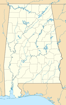
De onderstaande figuur toont de plaatsen in een straal van 32 km rond Bayou La Batre.
Externe link
| Bronnen, noten en/of referenties |
| Zie de categorie Bayou La Batre, Alabama van Wikimedia Commons voor mediabestanden over dit onderwerp. |
This article is issued from
Wikipedia.
The text is licensed under Creative
Commons - Attribution - Sharealike.
Additional terms may apply for the media files.