Bassetlaw
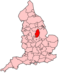
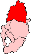
Bassetlaw is een Engels district in het shire-graafschap (non-metropolitan county OF county) Nottinghamshire en telt 117.000 inwoners. De oppervlakte bedraagt 638 km².
| Niet-metropolitaans district in Engeland | |||
  | |||
| Situering | |||
| Land | Engeland | ||
| County | Nottinghamshire | ||
| Regio | East Midlands | ||
| Coördinaten | 53°24'NB, 0°57'WL | ||
| Algemeen | |||
| Oppervlakte | 637,8033[1] km² | ||
| Inwoners (2018[2]) | 116839 (183 inw./km²) | ||
| ONS-code | E07000171 | ||
| |||
Van de bevolking is 16,2% ouder dan 65 jaar. De werkloosheid bedraagt 3,9% van de beroepsbevolking (cijfers volkstelling 2001).
Civil parishes in district Bassetlaw
Askham, Babworth, Barnby Moor, Beckingham, Bevercotes, Blyth, Bole, Bothamsall, Carburton, Carlton in Lindrick, Clarborough and Welham, Clayworth, Clumber and Hardwick, Cottam, Cuckney, Darlton, Dunham-on-Trent, East Drayton, East Markham, Eaton, Elkesley, Everton, Fledborough, Gamston, Gringley on the Hill, Grove, Harworth Bircotes, Haughton, Hayton, Headon cum Upton, Hodsock, Holbeck, Laneham, Lound, Marnham, Mattersey, Misson, Misterton, Nether Langwith, Normanton on Trent, North Leverton with Habblesthorpe, North Wheatley, Norton, Ragnall, Rampton, Ranskill, Rhodesia, Saundby, Scaftworth, Scrooby, Shireoaks, South Leverton, South Wheatley, Stokeham, Sturton le Steeple, Styrrup with Oldcotes, Sutton, Torworth, Treswell, Tuxford, Walkeringham, Wallingwells, Welbeck, West Burton, West Drayton, West Markham, West Stockwith, Wiseton.
Bronnen, noten en/of referenties
|