Barrington (Somerset)
Barrington is een civil parish in het bestuurlijke gebied South Somerset, in het Engelse graafschap Somerset met 438 inwoners.
| Civil parish in Engeland | |||
 | |||
| Situering | |||
| Regio | South West England | ||
| Graafschap | Somerset | ||
| District | South Somerset | ||
| Coördinaten | 50° 58' NB, 2° 53' WL | ||
| Algemeen | |||
| Oppervlakte | 4,5747 km² | ||
| Inwoners (2011) | 438 (96 inw./km²) | ||
| Overig | |||
| Postcode(s) | TA19 | ||
| Netnummer(s) | 01460 | ||
| Grid code | ST385185 | ||
| Post town | ILMINSTER | ||
| ONS-code | E04008663 | ||
| Foto's | |||
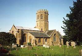 | |||
| Kerk van St. Mary | |||
| |||
Barrington Court
De belangrijkste toeristische attractie van het dorp is het landhuis, gebouwd in 1514.[1] Het pand is nu eigendom van de National Trust.
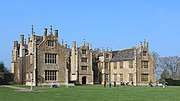 Hoofdgebouw uit het zuiden
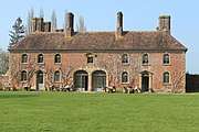 Westvleugel - voorheen de stallen
 Veelzijdige zonnewijzer in de tuinen
Verwijsings
- (en) Barrington Court. Historic England. Geraadpleegd op 30 November 2019.
Geplaatst op: 16-8-2010 |
Dit artikel is een beginnetje over landen & volken. U wordt uitgenodigd om op bewerken te klikken om uw kennis aan dit artikel toe te voegen. |
This article is issued from
Wikipedia.
The text is licensed under Creative
Commons - Attribution - Sharealike.
Additional terms may apply for the media files.