Aldgate (wijk)
Ward of Aldgate is een wijk in de regio Groot-Londen.
| Wijk in Londen in Engeland | |||
 | |||
| Situering | |||
| Regio | London | ||
| District | City of London | ||
| Coördinaten | 51° 31' NB, 0° 5' WL | ||
| Algemeen | |||
| Oppervlakte | 0,1123[1] km² | ||
| Overig | |||
| Postcode(s) | EC3 | ||
| Netnummer(s) | 020 | ||
| Grid code | TQ334813 | ||
| Post town | LONDON | ||
| |||
Aldgate was de meest oostelijke ingang (stadspoort) door de Londense omwalling op de weg van City of London naar Whitechapel en East End. Aldgate is ook de naam van een straat.
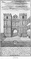 Tekening van de oude poort (old gate)
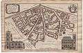 Kaart uit 1755 van Aldgate

| Bronnen, noten en/of referenties |
Geplaatst op: 12-07-2007 |
Dit artikel is een beginnetje over landen & volken. U wordt uitgenodigd om op bewerken te klikken om uw kennis aan dit artikel toe te voegen. |
This article is issued from
Wikipedia.
The text is licensed under Creative
Commons - Attribution - Sharealike.
Additional terms may apply for the media files.