Adair County (Iowa)
Adair County is een county in de Amerikaanse staat Iowa.
| County in de Verenigde Staten | |||
 | |||
| Situering | |||
| Staat | Iowa | ||
| Coördinaten | 41°19'50"NB, 94°28'16"WL | ||
| Algemeen | |||
| Oppervlakte | 1.477 km² | ||
| - land | 1.474 km² | ||
| - water | 3 km² | ||
| Inwoners (2000) | 8.243 (6 inw./km²) | ||
| Overig | |||
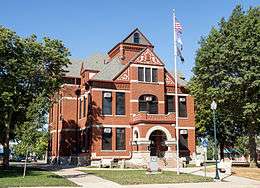
| Zetel | Greenfield | ||
| FIPS-code | 19001 | ||
| Opgericht | 1851 | ||
| Foto's | |||
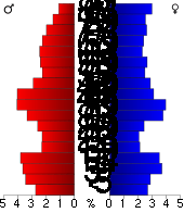 Bevolkingspiramide Adair County | |||
| Statistieken volkstelling Adair County | |||
| |||
De county heeft een landoppervlakte van 1474 km² en telt 8243 inwoners (volkstelling 2000). De hoofdplaats is Greenfield.
Bevolkingsontwikkeling
| Historische inwonertallen | |||
|---|---|---|---|
| Jaar | Inwoners | % ± | |
| 1900 | 16.192 | ||
| 1910 | 14.420 | −10,9% | |
| 1920 | 14.259 | −1,1% | |
| 1930 | 13.891 | −2,6% | |
| 1940 | 13.196 | −5,0% | |
| 1950 | 12.292 | −6,9% | |
| 1960 | 10.893 | −11,4% | |
| 1970 | 9.487 | −12,9% | |
| 1980 | 9.509 | 0,2% | |
| 1990 | 8.409 | −11,6% | |
| 2000 | 8.243 | −2,0% | |
| Bron: (en) Historical Decennial Census Population | |||
De hoofdstad van Adair County is Greenfield.
Steden en dorpen
| County's in de staat Iowa |
|---|
|
Adair · Adams · Allamakee · Appanoose · Audubon · Benton · Black Hawk · Boone · Bremer · Buchanan · Buena Vista · Butler · Calhoun · Carroll · Cass · Cedar · Cerro Gordo · Cherokee · Chickasaw · Clarke · Clay · Clayton · Clinton · Crawford · Dallas · Davis · Decatur · Delaware · Des Moines · Dickinson · Dubuque · Emmet · Fayette · Floyd · Franklin · Fremont · Greene · Grundy · Guthrie · Hamilton · Hancock · Hardin · Harrison · Henry · Howard · Humboldt · Ida · Iowa · Jackson · Jasper · Jefferson · Johnson · Jones · Keokuk · Kossuth · Lee · Linn · Louisa · Lucas · Lyon · Madison · Mahaska · Marion · Marshall · Mills · Mitchell · Monona · Monroe · Montgomery · Muscatine · O'Brien · Osceola · Page · Palo Alto · Plymouth · Pocahontas · Polk · Pottawattamie · Poweshiek · Ringgold · Sac · Scott · Shelby · Sioux · Story · Tama · Taylor · Union · Van Buren · Wapello · Warren · Washington · Wayne · Webster · Winnebago · Winneshiek · Woodbury · Worth · Wright |