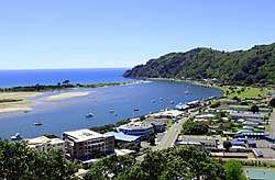
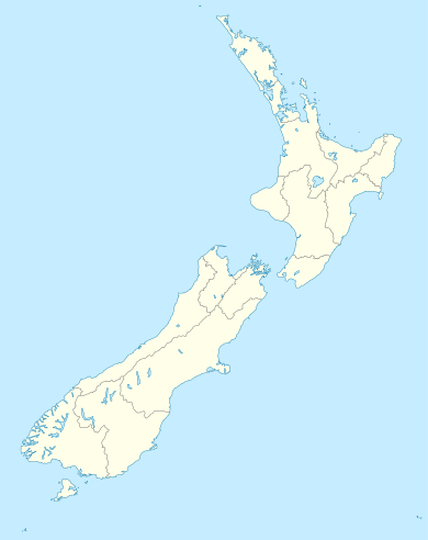
Whakatāne
Whakatāne (/fɑːkɑːˈtɑːnə/ fah-kah-TAH-nə, Māori pronunciation: [fakaˈtaːnɛ]), also spelled Whakatane, is a town in the eastern Bay of Plenty region in the North Island of New Zealand, 90 kilometres (56 mi) east of Tauranga and 89 kilometres (55 mi) north-east of Rotorua, at the mouth of the Whakatane River. Whakatane District is the encompassing territorial authority, which covers an area to the south and west of the town, excluding the enclave of Kawerau.
Whakatāne | |
|---|---|
Town | |
 | |
| Motto(s): Everything under the sun | |
 Whakatāne Location of Whakatāne | |
| Coordinates: 37°59′S 177°00′E | |
| Country | |
| Region | Bay of Plenty |
| Territorial authority | Whakatane District |
| Settled by Māori | c. 1200 |
| Government | |
| • Mayor | Judy Turner |
| • Deputy Mayor | Andrew Iles |
| Area | |
| • Territorial | 4,442.07 km2 (1,715.09 sq mi) |
| Population (June 2019)[1] | |
| • Territorial | 37,100 |
| • Density | 8.4/km2 (22/sq mi) |
| • Urban | 15,850 |
| Time zone | UTC+12 (NZST) |
| • Summer (DST) | UTC+13 (NZDT) |
| Postcode(s) | 3120 |
| Area code(s) | 07 |
| Website | http://www.whakatane.govt.nz/ Archived 25 February 2008 at the Wayback Machine |
Whakatāne has an urban population of 15,850, making it New Zealand's 33rd largest urban area, and the Bay of Plenty's third largest urban area behind Tauranga and Rotorua. Another 21,250 people live in the rest of the Whakatane District. Around 40% of the district's population have Māori ancestry. The district has a land area of 4,442.07 km2 (1,715.09 sq mi). Whakatane District was created in 1976.
Whakatāne forms part of the parliamentary electorate of East Coast, represented by Anne Tolley of the New Zealand National Party. It is the main urban centre of the eastern Bay of Plenty sub-region; incorporating Whakatāne, Kawerau, and Ōpōtiki, the eastern Bay stretches from Otamarakau in the west, to Cape Runaway in the north-east and Whirinaki in the south. It is the seat of the Bay of Plenty Regional Council, chosen as a compromise between the region's two larger cities, Tauranga and Rotorua.
History
Māori occupation
The site of the town has long been populated. Māori pā (Māori fortified village) sites in the area date back to the first Polynesian settlements, estimated to have been around 1200 CE. According to Māori tradition Toi-te-huatahi, later known as Toi-kai-rakau, landed at Whakatāne about 1150 CE in search of his grandson Whatonga. Failing to find Whatonga, he settled in the locality and built a pa on the highest point of the headland now called Whakatāne Heads, overlooking the present town. Some 200 years later the Mataatua waka landed at Whakatāne.[2]
The Maori name Whakatāne is reputed to commemorate an incident occurring after the arrival of the Mataatua. The men had gone ashore and the canoe began to drift. Wairaka, a chieftainess, said "Kia whakatāne au i ahau" ("I will act like a man"), and commenced to paddle – something that women were not allowed to do. With the help of the other women, the canoe was saved.[3] Wairaka's efforts are commemorated by a bronze statue of her at the mouth of the Whakatāne River, which was installed in 1965.[4][5]
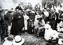
The region around Whakatāne was important during the New Zealand Wars of the mid 19th century, particularly the Volkner Incident. Its role culminated in 1869 with raids by Te Kooti's forces and a number of its few buildings were razed, leading to an armed constabulary being stationed above the town for a short while. Whakatāne beach heralded a historic meeting on 23 March 1908 between Prime Minister Joseph Ward and the Māori prophet and activist Rua Kenana Hepetipa.[6] Kenana claimed to be Te Kooti's successor.
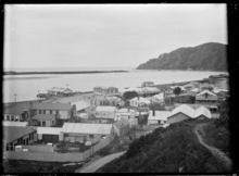
European settlement
.jpg)
The town was a notable shipbuilding and trade centre from 1880 and with the draining of the Rangitāiki swamp into productive farmland from 1904, Whakatāne grew considerably. In the early 1920s it was the fastest growing town in the country for a period of about three years and this saw the introduction of electricity for the first time. The carton board mill at Whakatāne began as a small operation in 1939[7] and continues operating to this day.
The Whakatāne River once had a much longer and more circuitous route along the western edge of the Whakatāne urban area, having been significantly re-coursed in the 1960s with a couple of its loopier loops removed to help prevent flooding and provide for expansion of the town. Remnants of the original watercourse remain as Lake Sullivan and the Awatapu lagoon. The original wide-span ferro-concrete bridge constructed in 1911 at the (aptly named) Bridge Street was demolished in 1984 and replaced by the Landing Road bridge.[8]
Whakatāne has in recent years benefited from its relative dominance over numerous smaller and less prosperous towns surrounding it, such as Te Teko (affectionately known as 'Texas') and Waimana, and its popularity as a retirement and lifestyle destination.
Mataatua Declaration
The 'First International Conference on the Cultural and Intellectual Property Rights of Indigenous Peoples' was held in Whakatāne from 12 to 18 June 1993. This resulted in the Mataatua Declaration on Cultural and Intellectual Property Rights of Indigenous Peoples', commonly referred to as the Mataatua Declaration.[9]
Demographics
| Historical population | ||
|---|---|---|
| Year | Pop. | ±% p.a. |
| 2006 | 33,300 | — |
| 2013 | 32,691 | −0.26% |
| 2018 | 35,700 | +1.78% |
| Source: [10] | ||
Whakatane District had a population of 35,700 at the 2018 New Zealand census, an increase of 3,009 people (9.2%) since the 2013 census, and an increase of 2,400 people (7.2%) since the 2006 census. There were 12,468 households. There were 17,442 males and 18,258 females, giving a sex ratio of 0.96 males per female. Of the total population, 8,013 people (22.4%) were aged up to 15 years, 6,177 (17.3%) were 15 to 29, 15,303 (42.9%) were 30 to 64, and 6,207 (17.4%) were 65 or older. Figures may not add up to the total due to rounding.
Ethnicities were 63.2% European/Pākehā, 46.8% Māori, 3.0% Pacific peoples, 3.4% Asian, and 1.3% other ethnicities. People may identify with more than one ethnicity.
The percentage of people born overseas was 11.8, compared with 27.1% nationally.
Although some people objected to giving their religion, 48.1% had no religion, 32.9% were Christian, and 11.7% had other religions.
Of those at least 15 years old, 4,089 (14.8%) people had a bachelor or higher degree, and 5,925 (21.4%) people had no formal qualifications. The median income was $26,300. The employment status of those at least 15 was that 12,303 (44.4%) people were employed full-time, 4,389 (15.9%) were part-time, and 1,587 (5.7%) were unemployed.[10]
Climate
| Climate data for Whakatāne, New Zealand | |||||||||||||
|---|---|---|---|---|---|---|---|---|---|---|---|---|---|
| Month | Jan | Feb | Mar | Apr | May | Jun | Jul | Aug | Sep | Oct | Nov | Dec | Year |
| Average high °C (°F) | 24 (75) |
24 (75) |
23 (73) |
21 (70) |
18 (64) |
15 (59) |
15 (59) |
15 (59) |
17 (63) |
19 (66) |
21 (70) |
22 (72) |
20 (67) |
| Daily mean °C (°F) | 19 (66) |
19 (66) |
18 (64) |
15 (59) |
12 (54) |
10 (50) |
9 (48) |
10 (50) |
12 (54) |
14 (57) |
16 (61) |
18 (64) |
14 (58) |
| Average low °C (°F) | 14 (57) |
14 (57) |
13 (55) |
10 (50) |
7 (45) |
5 (41) |
4 (39) |
5 (41) |
7 (45) |
9 (48) |
11 (52) |
13 (55) |
9 (49) |
| Average rainfall mm (inches) | 111 (4.4) |
100 (3.9) |
142 (5.6) |
108 (4.3) |
124 (4.9) |
148 (5.8) |
134 (5.3) |
153 (6.0) |
131 (5.2) |
116 (4.6) |
119 (4.7) |
149 (5.9) |
1,535 (60.4) |
| Mean monthly sunshine hours | 248.0 | 197.8 | 186.0 | 180.0 | 155.0 | 150.0 | 155.0 | 155.0 | 180.0 | 217.0 | 210.0 | 217.0 | 2,250.8 |
| Source #1: The Weather Network[11]
← --> | |||||||||||||
| Source #2: World Climate Guide[12] | |||||||||||||
Whakatāne has frequently recorded the highest annual sunshine hours in New Zealand (year and respective sunshine hours shown below). Since official recording began in 2008, the town has frequently attained upwards of 2600 hours a year. The town recorded an average of over 7.5hrs of sunshine a day in 2013.[13] Whakatāne also records the national daily high (temp) on approximately 55 days of the year.[14]
Natural disasters
Whakatāne was affected by the 1987 Edgecumbe earthquake. Heavy rain struck the Bay of Plenty region between 16–18 July 2004, resulting in severe flooding and a state of civil emergency being declared. Many homes and properties were flooded, forcing thousands of Whakatāne residents to evacuate. The Rangitaiki River burst its banks, flooding large areas of farmland, and numerous roads were closed by floods and slips. A total of 245.8 mm of rain fell in Whakatāne in the 48-hour period and many small earthquakes were also felt during this time, loosening the sodden earth and resulting in landslips that claimed two lives.
Geography
Moutohora Island is a small island off the Bay of Plenty coast about 12 kilometres north of Whakatāne. The island has numerous sites of pā. It also provided shelter for James Cook's Endeavour in 1769. A whaling station existed on the island during the 19th century.
Whakaari/White Island is an active marine volcano located 48 kilometres offshore of Whakatāne and a popular visitor attraction. Sulphur mining on the island was attempted but abandoned in 1914 after a lahar killed all 10 workers.
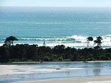
The mouth of the Whakatāne River and Ohiwa Harbour have both provided berths for yachts, fishing trawlers and small ships since European settlement of the area. Nearby Ōhope Beach is a sandy beach stretching 11 km (7 mi) from the Ohiwa Harbour entrance.
Industries and tourism
The town's main industries are diverse: forestry, tourism, agriculture, horticulture, fishing and manufacturing are all well-established. There is a large carton board packaging mill, a newspaper press, and a brewery.
While farming and forestry activities remain the dominant sectors, tourism is a growing industry for Whakatāne, with a continued increase in guest nights in the district.[15] White Island is a key attraction. Popular tourist activities include the beaches, swimming with dolphins, whale watching, chartered fishing cruises, surf tours, amateur astronomy, hunting, experiences of Maori culture and bush walking. Whakatāne is also used as a base for many tourists who wish to explore other activities in the surrounding region.
Aquaculture is an emerging industry for the Eastern Bay, with the development of a 3800 hectare marine farm 8.5 km offshore of Ōpōtiki, expected to produce 20,000 tonnes of mussels per annum by 2025 and add $35 million to regional GDP.[16] Whakatāne is home to the regional radio station One Double X - 1XX – one of the first privately owned commercial radio stations on air in New Zealand in the early 1970s.
Whakatāne has become the dominant commercial service centre for the Eastern Bay. In 2006, a large-format shopping centre (The Hub Whakatane) was built on the edge of town anchored by national chains Bunnings Warehouse and Harvey Norman. Its retail space totals 24,000sqm and includes 900 car parks.[17] Prior to the centre's construction, it was estimated around $30 million in local retail spending was being lost to large format retail stores in neighboring Tauranga and Rotorua.
Infrastructure

Whakatane Airport is served by Air Chathams with direct flights to Auckland using Fairchild Swearingen Metroliner aircraft. Air New Zealand previously operated the Auckland service until April 2015.[18] Private cars, limited public transport and taxis (as well as cycling and walking) are the primary modes of transport for residents. A regular public bus service runs between Whakatāne and Ōhope. Furthermore, once daily return bus services operate to Tauranga, en route from Kawerau and Ōpōtiki on alternate weekdays.
Whakatāne sits at the eastern end of State Highway 30. State Highway 2 bypasses the urban area.
Whakatāne has two secondary schools, Whakatane High School and Trident High School. Two tertiary institutes, Te Whare Wananga O Awanuiarangi and Toi Ohomai Institute of Technology, have campuses in Whakatāne.
Marine
.jpg)
Coastal trading, including scows and steamships – notably the Northern Steamship Company service, which ran until 1959, used Whakatāne as a port of call. Today it primarily services charter vessels, commercial & recreational fishing vessels. The depth of water over the Whakatane River entrance has been a limiting factor to the development of better port facilities, but it is generally held that a training wall along the western edge of the entrance would allow greater depths and safer crossings.
Rail
A passenger train called the Taneatua Express ran on the East Coast Main Trunk Railway (ECMT) as far as Taneatua until 1959. The Taneatua Branch line was formerly part of the ECMT and connected with the current ECMT at Hawkens Junction.
A private railway line operated by Whakatane Board Mills (now Carter Holt Harvey Whakatāne) formerly connected the company's mill on the western side of the river to the Taneatua Branch line at Awakeri. The Whakatane Board Mills Line was freight only, with no passenger service. In 1999 operation of the Whakatane Board Mills line was taken over by Tranz Rail (now KiwiRail) and the line was renamed the Whakatane Industrial line. The line has since been closed and lifted, and the Taneatua Branch line is used for tourist excursions.
Sister cities
.svg.png)
Whakatāne has a friendship agreement with Shibukawa, Gunma, Japan.[21]
Notable people
- Lisa Carrington, New Zealand flatwater canoer
- Lindy Chamberlain, New Zealand-Australian woman wrongly convicted in one of Australia's most publicised murder trials
- Maurice Gee, New Zealand author
- Joe Harawira, environmental campaigner
- Francis Kora, Māori musician and actor
- Margaret Mahy, New Zealand author
- Benji Marshall, New Zealand rugby league and rugby union player
- Mike Moore, New Zealand politician and Prime Minister
- Albert Oliphant Stewart (1884–1958), tribal leader and local politician[22]
- Rex Patrick, Australian politician
- Alexander Peebles (1856–1934), first chairman of the Whakatāne County Council in 1900[23]
- Eve Rimmer, New Zealand paraplegic athlete
- Ian Shearer, New Zealand politician
- Sarah Walker, New Zealand BMX racer
Gallery
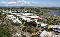 Whakatāne township, looking west
 Looking southwest
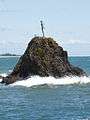 The Wairaka sculpture at the Whakatāne Heads
 The Whakatāne River at sunset
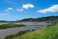 Along the River Edge Walkway
References
- "Subnational Population Estimates: At 30 June 2019". Statistics New Zealand. 22 October 2019. Retrieved 11 January 2020.
- McLintock, A. H. (1966). "An Encyclopaedia of New Zealand". Archived from the original on 27 September 2007. Retrieved 24 August 2006.
- "The legend of Wairaka and the naming of Whakatāne". Archived from the original on 27 September 2007. Retrieved 13 July 2007.
- "Wairaka Statue". Whakatane.info. Archived from the original on 21 January 2019. Retrieved 21 January 2019.
- "The Lady on the Rock". Whakatane.com. Archived from the original on 21 January 2019. Retrieved 21 January 2019.
Unveiled at the Whakatāne Heads in 1965 as a memorial to the wife of Sir William Sullivan.
- Binney, Judith (1996). "Rua Kenana Hepetipa meeting with Joseph George Ward on the beach at Whakatāne, March 1908". Te Ara – the Encyclopedia of New Zealand. Archived from the original on 21 January 2019. Retrieved 21 January 2019.
Rua Kenana Hepetipa's meeting with Joseph George Ward on the beach at Whakatāne in March 1908 was later described as the 'Ceremony of Union'...
- "Whakatāne Board Mill". Archived from the original on 24 January 2012. Retrieved 2 October 2012.
- Skelton, H (2002) Pictures from the Past- Bay of Plenty, Volcanic Plateau & Gisborne. Wyatt and Wilson Print, Christchurch. ;pg 76.
- "The Mataatua Declaration on Cultural and Intellectual Property Rights of Indigenous Peoples" (PDF). Ngati Awa. June 1993. Archived from the original (PDF) on 22 January 2016. Retrieved 6 January 2016.
- "Statistical area 1 dataset for 2018 Census". Statistics New Zealand. March 2020. Whakatane District (025).
- "Climate Statistics for Whakatāne, New Zealand". Retrieved 16 May 2012.
- "Whakatāne Climate Guide, New Zealand". Archived from the original on 5 March 2013. Retrieved 29 May 2013.
- Bonne, Tony. "Whakatāne – NZ's sunshine capital". Archived from the original on 4 May 2014. Retrieved 5 May 2014.
- "Archived copy". Archived from the original on 5 February 2013. Retrieved 15 May 2013.CS1 maint: archived copy as title (link)
- "Whakatāne Tourism Numbers positive". Sunlive. 20 March 2015.
- Halford, B. "Auditors report on the Opotiki Long Term Plan 2012–2022". Audit New Zealand.
- "The Hub Whakatane". McDougall Reidy. Archived from the original on 23 May 2015. Retrieved 22 May 2015.
- "Air NZ announces regional network cuts". Stuff.co.nz. 11 November 2014. Archived from the original on 11 November 2014. Retrieved 11 November 2014.
- "International Exchange". List of Affiliation Partners within Prefectures. Council of Local Authorities for International Relations (CLAIR). Archived from the original on 4 March 2016. Retrieved 21 November 2015.
- "Sister cities". Whakatane District Council. 25 November 2013. Archived from the original on 3 April 2019. Retrieved 15 May 2019.
- "Sister Cities". Whakatane District Council. Archived from the original on 23 April 2012. Retrieved 31 December 2011.
- Haami, Bradford. "Albert Oliphant Stewart". Dictionary of New Zealand Biography. Ministry for Culture and Heritage. Retrieved 23 April 2017.
- Heath, Alison B. "Alexander Peebles". Dictionary of New Zealand Biography. Ministry for Culture and Heritage. Retrieved 23 April 2017.