Tungabhadra River
The Tungabhadra River is a river in India that starts and flows through the state of Karnataka during most of its course, before flowing along the border between Telangana, Andhra Pradesh and ultimately joining the Krishna River near Sangameswaram village in Kurnool district of Andhra Pradesh. In the epic Ramayana, the Tungabhadra River was known by the name of Pampa.
| Tungabhadra River | |
|---|---|
 Tungabhadra River at Hampi | |
 A map featuring the river | |
| Location | |
| Country | India |
| State | Karnataka, Telangana, Andhra Pradesh |
| Cities | Harihar, Hospet, Hampi, Kampli, Mantralayam, Kurnool |
| Physical characteristics | |
| Source | Koodli (The place where the Thunga and Bhadra rivers meet) |
| ⁃ location | Koodli, Bhadravathi, Karnataka, India |
| ⁃ coordinates | 14°0′30″N 75°40′27″E |
| ⁃ elevation | 610 m (2,000 ft) |
| Mouth | Krishna River |
⁃ location | Sangameswaram, Kurnool District, Andhra Pradesh, India |
⁃ coordinates | 15°53′19″N 78°09′51″E |
⁃ elevation | 264 m (866 ft) |
| Length | 531 km (330 mi) |
| Basin size | 71,417 km2 (27,574 sq mi) |
| Discharge | |
| ⁃ location | Krishna River |
| Basin features | |
| Tributaries | |
| ⁃ left | Tunga River, Kumudvati River, Varada River |
| ⁃ right | Bhadra River, Vedavathi River, Handri River |
Course
The Tungabhadra River is formed by the confluence of the Thunga River and the Bhadra River at Koodli which flow down the eastern slope of the Western Ghats in the state of Karnataka. The two rivers originate in Mudigere Taluk of Chikmagalur District of Karnataka along with the Nethravathi (west-flowing river, joining the Arabian Sea near Mangalore), the Tunga and the Bhadra rise at Gangamoola, in Varaha Parvatha in the Western Ghats at an elevation of 1198 metres (near Samse Village). According to a Hindu mythological legend, after killing the demon Hiranyaksha, Varaha Swamy (the third incarnation of Lord Vishnu) felt very tired. He took rest on the region now known as Varaha Parvatha. When He sat on that peak, sweat began flowing from his scalp. The sweat which flowed from the left side of his scalp became the Tunga river, and the sweat which flowed from his right side became Bhadra River. After emerging from the source, the Bhadra river flows through Kudremukh mountain region, Tarikere Taluk and the industrial city of Bhadravathi, while the Tunga river flows through Sringeri Taluk, Thirthahalli Taluk and Shimoga Taluk. More than 100 tributaries, streams, creeks, rivulets and the like contribute to the two rivers. The journey of the Tunga and the Bhadra is 147 km (91 mi) and 171 km (106 mi) respectively, till they join at Koodli, at an elevation of about 610 metres near Holehonnur, about 15 km (9.3 mi) from Shivamogga, areca granary of the country. Though both Tunga and Bhadra rivers start at same source (Gangamoola), they flow separately for some distance and then they later unite with each other at Koodali village. Hence from there, the name Tungabhadra was given. From there, the Tungabhadra meanders through the plains to a distance of 531 km (330 mi). After confluence, The mighty Tungabhadra river flows through Honnali and Harihara taluks of Davangere district. Then it flows through Harapanahalli, Hoovina Hadagali, Hagaribommanahalli, Hospet and Siruguppa Taluks of Bellary district. In Siruguppa Taluk of Bellary district, it receives its tributary Vedavathi River. The river forms a natural boundary between Bellary and Koppal districts and then between Bellary and Raichur districts along its course. After entering Andhra Pradesh, it flows through Mantralaya and then through Kurnool. It receives its tributary Handri river near Kurnool. Then it joins the Krishna near Alampur Village of Mehboobnagar district of Telangana state. The confluence of Tungabhadra and Krishna River is a holy pilgrimage site. The Sangameshwara temple and Jogulamba temple(dedicated to Lord Shiva and Goddessess Devi respectively) are present near Alampur village. The Varada flowing through Shimoga, Uttara Kannada and Haveri districts and Vedavathi in Chikkamagalur, Chitradurga and Bellary districts in Karnataka and the Handri in Kurnool district of Andhra Pradesh are the main tributaries of the Tungabhadra. Many rivulets and streams join these tributaries. There is a popular saying in Kannada "Tunga Paana, Ganga Snana", which means "Drink Tunga River water, which is tasty & sweet, and bathe in Ganga River, which is holy".
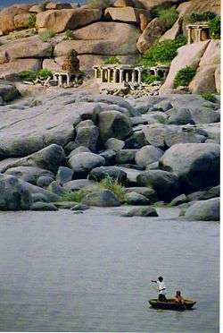
There are many holy places all along the rivers: primarily temples of Saiva cult on the banks of the Bhadra and all the cults on the banks of the Tunga. Sringeri, Sarada Peetham established by the Adi Shankaracharya is the most famous one on the left bank of the Tunga, about 50 km (31 mi) downstream of its origin. Hampi one of the important heritage locations being listed by UNESCO is on the banks of Tunga Bhadra River. Nava Brindavan, an island where the final resting location of nine holy Madhva saints is in the midst of Tunga Bhadra River. One can view Tunga Bhadra River from famous Yantroddaraka Hanuman Temple at Hampi. Virupaksha Temple is also on the banks of Tunga Bhadra River. The resting spot of Vasudendra Teertha is also on the banks of Tunga bhadra River at Kenchangudda, Siruguppa. Manthralayam Sree Raghavendra Swamy Muth in Kurnool District and Alampur in Mehboobnagar District, Jogulamba is the presiding deity, known as Dakshina Kashi are the other important pilgrimage centres. There is a cluster of Nava Brahma temples constructed by the early Chalukyas.
An important feature of the river banks is the flood protection walls all along the rivers, constructed by Sri Krishna Devaraya between 1525 and 1527 AD. They are found wherever there is a possibility of land erosion during the floods. It starts at Sringeri and ends at Kurnool, just few kilometers from its mouth. They are stone constructions and still intact. Very large boulders of 3' x 4' x 5' are also used in its construction.
Piles of granite in varying shades of grey, ochre and pink dominate the landscape. The river has cut through weaker rocky substrata of the Hampi landscape and created a narrow gorge where granite hills confine the river in a deep ravine.[1]
In this setting the ruins of Vijayanagara and Hampi, the seat of power of the Vijayanagar empire, overlook this holy river, creating a mythological landscape merging sacred traditions about a multitude of significant divinities.[2]
The granite outcrops slowly disappear as the river flows south and the land opens into a long, broad plain ending at the rising slopes of the Sandur hills, rich in iron and manganese, beyond which is the town of Hosapete. The Tungabhadra Dam was constructed at Hosapete in the middle of the 20th century to harness the river water, aiding the growth of agriculture and industry in the region.
The Tungabhadra River then flows east, joining the Krishna in Andhra Pradesh. From here the Krishna continues east to empty into the Bay of Bengal. The wedge of land that lies north of the Tungabhadra River, between the Tungabhadra and the Krishna, is known as the Raichur Doab.
Temples
- The Huligema Temple on banks of Tungabhadra River at Koppal district, Karnataka.
- The Markendeshwara Temple dedicated to Lord Shiva on banks of Tungabhadra river at Shivapur village, Koppal district, Karnataka.
- Sri Shringeri Sharadamba Temple dedicated to Goddess Saraswathi on the banks of the Tunga River in Chikmagalur district, Karnataka.
- Bidarallamma Temple dedicated to Goddess Renuka on the banks of the Tunga River in Gadag district, Mundaragi taluk Karnataka.
- Pampapati Temple in Kampli of Ballari district, Karnataka.
- There are a number of ancient and holy sites on the banks of the Tungabhadra River. At Harihara there is a temple dedicated to Harihareshwara. Surrounding the modern town of Hampi are the ruins of Vijayanagara, the site of the powerful Vijayanagara Empire's capital city and now a World Heritage Site. The site, including the Vijayanagara temple complex ruins, are being restored.
- The Moola Brindavana of Guru Raghavendra Swamy is located on the banks of the Tungabhadra river at Mantralayam, Kurnool district, Andhra Pradesh.
- Sri Dakshina Shirdi Sai Baba Temple dedicated to Sai Baba, known as Dakshina Shirdi on banks of the Tungabhadra River at Kurnool, Kurnool district, Andhra Pradesh.
- Sri Jogulamba Temple dedicated to Goddess Parvathi, known as Dakshina Kashi in Alampur about 25 km from Kurnool, where the early Chalukyas built a cluster of temples on the left northern banks of the Tungabhadra river. The Nava Brahma Temples complex is one of the earliest models of temple architecture in India.
- The Sangameswaram Temple dedicated to Lord Shiva at place where several holy rivers meet in Sangameswaram, Kurnool district, Andhra Pradesh. According to the myth, once the Pandavas of Mahabharata came to Kurnool during their exile. They decided to install a Shiva Linga in this region after visiting Srisailam Mallikarjuna Temple. So, Dharmaraya (Yudhishtira) told his brother Bhima to bring a Shiva Linga from Kashi. Later, they consecrated the Linga at the confluence of the Krishna River and Tungabhadra River along with other five tributaries. Hence, the Linga was named as Sangameshwara (Sangama, where the rivers meet).
Dams
A dam was constructed about 15 km upstream from Shimoga at Gajanur across the River Tunga. Another dam was constructed at Lakkavalli about 15 km upstream of Bhadravati across the River Bhadra. They are multipurpose dams and irrigate lands in Shimoga, Chikkamagalur, Davanagere and Haveri.
Tungabhadra Dam is across the river Tungabhadra, a tributary of River Krishna. The dam is near the town of Hosapete in Karnataka. It is considered a multipurpose dam. Its storage capacity is 135 Tmcft. Owing to siltation, the capacity has come down by about 30 tmcft. If there are seasonal and late rains, the dam releases an estimated 235 tmcft. It is filled when water is let into the canals during the rainy season. The main architect of the dam was Thirumalai Iyengar, an engineer from Madras; a general-purpose hall was named after him. (Multipurpose dams help in generation of electricity, irrigation of land, prevention and control of floods, etc.) It has become a picnic or tourist spot over the years. Tungabhadra Dam is near heritage site Hampi. One of the major problems and concerns associated with TB Dam is it has been undergoing lot of silting. Because of silt deposition in the dam, the storage capacity of the dam is coming down. Another major problem associated with TB Dam is increased pollution, resulting in decreasing fish population. This is seriously affecting fishermen, who are solely dependent on the river for their livelihood.
The Sunkesula Barrage near Kurnool city, a long Barrage Dam was constructed across Tungabhadra River around 1860 by the British engineer, hailed as Bhagiratha Sir Arthur Cotton for Rayalaseema. Originally it was intended to be used for navigation during British Raj. The barrage was reconstructed by the Kotla Vijayabhaskara Reddy as Tungabhadra Barrage, to provide irrigation supply for Kadapa district. As the road and rail transportation increased, it is now supplying water for Kurnool and Kadapa districts, through the K. C. Canal. It impounds about 15,000,000,000 cubic feet (0.42 km3) of water and irrigates about 300,000 acres (1,200 km2) amount of lands in Kurnool and Kadapa districts.
Problems
Industrial pollution has damaged the Tungabhadra River. Industry and mining on its banks in the Chikkamagaluru, Shimoga, Davangere, Haveri, Bellary, Koppal, Raichur districts of Karnataka and Kurnool district of Andhra Pradesh generate enormous amounts of effluents. Nearly three crore litres of effluents are being released to the Tunga from Shimoga every year."[3] This is the contribution of just one city which, unlike Bhadravathi and Hospet, cannot boast of being an industrial city. It is one of the most polluted rivers in the country.
Downriver from the industries, the water has turned dark brown and has a pungent odor. Tungabhadra river's pollution has affected 1 million people in the sub-basin as most villages use the river water for drinking, bathing, irrigating crops, fishing and livestock water, previously obtained through an ancient tank system. The livelihood of village fishermen has been harmed by regular fish kills that have exhausted Tungabhadra's fisheries.[4]
Gallery
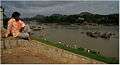 Contemplating the river, in Hampi
 Near Hampi
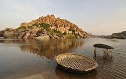
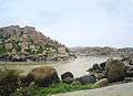 Tungabhadra Basin
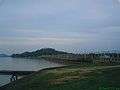 Tungabhadra Reservoir
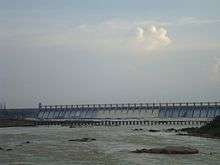 Tungabhadra Dam in Hosapete
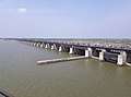 Sunkesula Barrage in Kurnool
See also
- List of dams and reservoirs in India
- Tungabhadra Pushkaralu
- Kishkindha
- Sunkesula
References
- "Physical landscape of Vijayanagara". Retrieved 20 September 2006.
- "Vijayanagara Site". Retrieved 18 June 2014.
- The Hindu, 6 June 2008
- "River Krishna". Retrieved 20 September 2006.
External links
| Wikimedia Commons has media related to Tungabhadra River. |