Southeast Alaska
Southeast Alaska (Russian: Юго-Восточная Аляска), colloquially referred to as the Alaska Panhandle or Alaskan Panhandle, is the southeastern portion of the U.S. state of Alaska, bordered to the east by the northern half of the Canadian province of British Columbia. The majority of Southeast Alaska's area is part of the Tongass National Forest, the United States' largest national forest. In many places, the international border runs along the crest of the Boundary Ranges of the Coast Mountains (see Alaska boundary dispute). The region is noted for its scenery and mild, rainy climate.
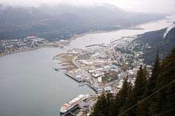
The largest cities in the region are Juneau, Sitka, and Ketchikan. This region is also home to the easternmost town in Alaska, Hyder.
Geography
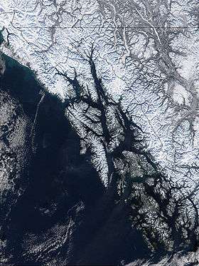
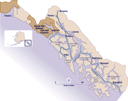
Southeast Alaska has a land area of 35,138 square miles (91,010 km2), comprising much of the Alexander Archipelago. The largest islands are, from North to South, Chichagof Island, Admiralty Island, Baranof Island, Kupreanof Island, Revillagigedo Island and Prince of Wales Island. Major bodies of water of Southeast Alaska include Glacier Bay, Lynn Canal, Icy Strait, Chatham Strait, Stephens Passage, Frederick Sound, Sumner Strait, and Clarence Strait.
The archipelago is the northern terminus of the Inside Passage, a protected waterway of convoluted passages between islands and fjords, beginning in Puget Sound in Washington state. This was an important travel corridor for Tlingit, Haida, and Tsimshian Native peoples, as well as gold-rush era steamships. In modern times it is an important route for Alaska Marine Highway ferries as well as cruise ships.
Demographics
.jpg)
Southeast Alaska is composed of seven entire boroughs and two census areas, in addition to the portion of the Yakutat Borough lying east of 141° West longitude. Although it has only 6.14 percent of Alaska's land area, it is larger than the state of Maine, and almost as large as the state of Indiana. The Southeast Alaskan coast is roughly as long as the west coast of Canada.
The 2010 census population of Southeast Alaska was 71,616 inhabitants, about 45 percent of whom were concentrated in the city of Juneau. As of 2018, the number of settlements in Southeast Alaska that have a population of at least 1,000 people has grown to nine.
Boroughs
- Haines Borough
- Hoonah-Angoon Census Area
- Juneau Borough
- Ketchikan Gateway Borough
- Petersburg Borough
- Prince of Wales-Hyder Census Area
- Sitka Borough
- Skagway Borough
- Wrangell Borough
- Yakutat Borough (the part east of 141° W longitude; 12,506.53 km2 / 4,828.80 sq mi, or about 63.12 percent of the borough)
Major cities and towns
Populations are based off 2018 estimates, except for Haines and Metlakatla which are based off the 2010 Census.[1]
National parks and monuments
Southeast Alaska includes the Tongass National Forest (which manages Admiralty Island National Monument and Misty Fjords National Monument), Glacier Bay National Park, Sitka National Historical Park, Alaska's Inside Passage, and myriad large and small islands. It is the largest national park in the United States. On August 20, 1902, President Theodore Roosevelt established the Alexander Archipelago Forest Reserve, which formed the heart of the Tongass National Forest that covers most of the region.
- Glacier Bay National Park and Preserve
- Klondike Gold Rush National Historical Park
- Sitka National Historical Park
- Wrangell–St. Elias National Park and Preserve (part, the most southeastern section only)
- Admiralty Island National Monument
- Misty Fjords National Monument
Climate
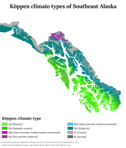
The climate of Southeast Alaska is dominated by a mid-latitude oceanic climate (Köppen Cfb) in the south, an oceanic, marine sub-polar climate (Köppen Cfc) in the central region around Juneau, and a subarctic climate (Köppen Dfc) to the far northwest and the interior highlands of the archipelago. Southeast Alaska is also the only region in Alaska where the average daytime high temperature is above freezing during the winter months.
Ecology
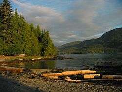
Southeast Alaska is a temperate rain forest within the Pacific temperate rain forest zone, as classified by the World Wildlife Fund's ecoregion system, which extends from northern California to Prince William Sound. The most common tree species are sitka spruce and western hemlock.
Wildlife includes brown bears, black bears, endemic Alexander Archipelago wolf packs, Sitka black-tailed deer, humpback whales, orcas, five species of salmon, bald eagles, harlequin ducks, scoters, and marbled murrelets.
The Ecological Atlas of Southeast Alaska, published by Audubon Alaska in 2016, offers an overview of the region's landscape, birds, wildlife, human uses, climate change, and more, synthesizing data from agencies and a variety of other sources.
Culture
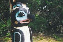
This area is the traditional homeland of the Tlingit, and home of a historic settling of Haida as well as a modern settlement of Tsimshian. The region is closely connected to Seattle and the American Pacific Northwest economically and culturally.
Industry
Major industries in Southeast Alaska include commercial fishing and tourism (primarily the cruise ship industry).
Logging
Logging has been an important industry in the past, but has been steadily declining with competition from other areas and the closure of the region's major pulp mills; the Alaska Forest Association described the situation as "desperate" in 2011.[2] Its members include Alcan Forest Products (owned by Canadian Transpac Group, one of the top 5 log exporters in North America[3]) and Viking Lumber, which is based in Craig, Alaska.[4] Debates over whether to expand logging in the federally owned Tongass are not uncommon.[5][6]
Mining
Mining remains important in the northern area with the Juneau mining district and Admiralty mining district hosting active mines as of 2015. Gold was discovered in 1880 and played an important part in the early history of the region.[7]
In the 2010s, mines increasingly begun to be explored and eventually completed in neighboring British Columbia, upstream of important rivers such as the Unuk and the Stikine, which became known as the transboundary mining issue. In 2014, the Mount Polley Mine disaster focused attention on the issue, and an agreement between Canada and Alaska was drafted in 2015.[8]
The proposed Kerr Sulphurets Mitchell exploration is upstream of the Unuk. Mines upstream of the Stikine include the Red Chris, which is owned by the same company (Imperial Metals) as the Mount Polley mine.[9]
History
The border between Alaska and the Canadian province of British Columbia was the subject of the Alaska boundary dispute, where the United States and the United Kingdom claimed different borderlines at the Alaskan panhandle. While the British foreign affairs were in favor of support of the Canadian argument, the event resulted in what was thought of as a betrayal, leading to alienation of the British from the new nation of Canada.
Transportation
Due to the extremely rugged, mountainous nature of Southeastern Alaska, almost all communities (with the exception of Hyder, Skagway, and Haines) have no road connections outside of their locale, so aircraft and boats are the major means of transport. The Alaska Marine Highway passes through this region.
Air transportation
Alaska Airlines is by far the largest air carrier in the region, with Juneau's Juneau International Airport serving as the aerial hub for all of Southeast and Ketchikan's Ketchikan International Airport serving as a secondary hub for southern Southeast Alaska. Alaska's bush airlines and air taxis serve many of the smaller and more isolated communities and villages in the regions. Many communities are accessible by air only by floatplane, as proper runways are often difficult to construct on the steep island slopes.
Marine transportation
Southeast Alaska is primarily served by the state-run Alaska Marine Highway, which links Skagway, Haines, Hoonah, Juneau, Sitka, Petersburg, Wrangell, Ketchikan and other outlying communities with Prince Rupert, BC and Bellingham, Washington; and secondarily by the Prince of Wales Island-based Inter-Island Ferry Authority, which provides the only scheduled passenger and auto ferry service to the island. A new Authority, the Rainforest Islands Ferry Authority, was created and in 2014 may possibly operate the North End route. The Authority would connect Coffman Cove with Wrangell and Petersburg. Small companies like Sitka-based Allen Marine and other independent operators in the Lynn Canal occasionally also offer marine passenger service. Ship traffic in the area is seasonally busy with cruise ships.
See also
- Alexander Archipelago
- Alexander Archipelago wolf
- Climate change in southeast Alaska
- List of edible plants and mushrooms of southeast Alaska
References
- Bureau, U. S. Census. "U.S. Census website". United States Census Bureau. Retrieved 2019-09-19.
- "AK Forest Association: SE timber situation 'desperate'". The Alaska Journal of Commerce. Archived from the original on 2016-04-19. Retrieved 2016-03-22.
- "Our History - Trans-Pacific Energy Group". Trans-Pacific Energy Group. Archived from the original on 2016-03-17. Retrieved 2016-03-22.
- "Viking Lumber Company, Inc". TPM. Retrieved 2019-10-14.
- SitNews. "SitNews: Murkowski Questions Forest Service Spending, Timber Sales;". www.sitnews.us. Archived from the original on 2016-11-06. Retrieved 2016-03-22.
- "In Alaska, a Battle to Keep Trees, or an Industry, Standing - NYTimes.com". mobile.nytimes.com. Archived from the original on 2016-11-06. Retrieved 2016-03-22.
- Sisk, John. "The Southeastern Alaska Timber Industry: Historical Overview and Current Status" (PDF). Archived (PDF) from the original on 2016-11-06.
- Schoenfeld, Ed; Juneau, CoastAlaska-. "Alaska drafts transboundary mine agreement with BC". Alaska Public Media. Archived from the original on 2015-11-19. Retrieved 2016-03-22.
- "B.C. government approves permits for controversial Red Chris Mine". www.cbc.ca. Archived from the original on 2016-02-22. Retrieved 2016-03-22.
External links
- The regional economy of southeast Alaska: final report, 2007 / prepared for Alaska Conservation Foundation; prepared by Steve Colt, Darcy Dugan, Ginny Fay (EcoSystems). Hosted by Alaska State Publications Program.
- Southeast Alaska energy export study: final report, 2006 / prepared for The Southeast Conference; by D. Hittle & Associates, Inc., in association with Commonwealth Associates, Inc. Hosted by the Alaska State Publications Program.
- Swan - Tyee intertie economic analysis, 2006 / prepared for the Four Dam Pool Power Agency; prepared by Commonwealth Associates, Inc. Hosted by Alaska State Publications Program.
- The Economic Impacts of the Alaska Marine Highway System, January 2016 / Prepared for Alaska Marine Highway System; Prepared by McDowell Group
Juneau (capital) | ||
| Topics |
|  |
| Society |
| |
| Regions |
| |
| Largest cities pop. over 25,000 | ||
| Smaller cities pop. over 2,000 |
| |
| Boroughs | ||
| Census Areas |
| |