Pearl, Mississippi
Pearl is a city in Rankin County, Mississippi located on the east side of the Pearl River from the state capital of Jackson. The population was 25,092 at the 2010 census. It is part of the Jackson Metropolitan Statistical Area.
Pearl, Mississippi | |
|---|---|
| City of Pearl | |
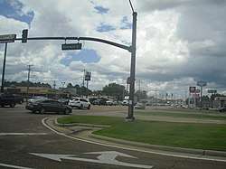 Pearl, Mississippi on Riverwind Drive | |
 Flag  Seal | |
| Nickname(s): The Pearl of the South | |
| Motto(s): "The City Creating Its Own Future"[1] | |
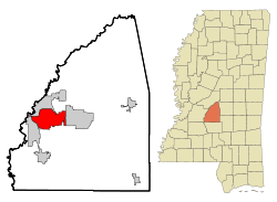 Location in Rankin County, Mississippi | |
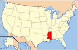 Location of Mississippi in the United States | |
 Pearl, Mississippi Location in the United States | |
| Coordinates: 32°16′19″N 90°06′19″W | |
| Country | United States |
| State | Mississippi |
| County | Rankin |
| Founded | 1865 |
| Incorporation | June 29, 1973 |
| Government | |
| • Type | Weak Mayor-Council |
| • Mayor | Jake Windham (R) |
| • Board of Aldermen | David Luckett (R) - Dist. 1 Michael Sartor (R) - Dist. 2 Johnny Steverson (R) - Dist. 3 Casey Foy (R) - Dist. 4 James Thompson (I) - Dist. 5 Gavin Gill (R) - Dist. 6 John McHenry (R) - At-large |
| Area | |
| • Total | 25.61 sq mi (66.33 km2) |
| • Land | 25.47 sq mi (65.96 km2) |
| • Water | 0.14 sq mi (0.37 km2) |
| Elevation | 276 ft (84.1 m) |
| Population (2010) | |
| • Total | 25,092 |
| • Estimate (2018)[3] | 26,471 |
| • Density | 1,041.94/sq mi (402.29/km2) |
| Time zone | UTC−6 (CST) |
| • Summer (DST) | UTC−5 (CDT) |
| Zip Code(s); physical locations | 39208 |
| Zip Code(s); U.S. P.O. boxes | 39288 |
| Area code(s) | 601, 769 |
| FIPS code | 28-55760[4] |
| GNIS feature ID | 0675537[5] |
| Website | http://www.cityofpearl.com |
| For additional city data see: City-Data | |
Today, Pearl is a growing community; it is the 13th largest city in the state and the largest city in Rankin County.
History
After the American Civil War, the bottomlands of the Pearl River were developed for agriculture. The population was sparse until the mid-1900s when the development of the state capital of Jackson in Hinds County to the west spilled over into this county. New residents and industry settled here. Thereafter, growth in the area came from the urban expansion of the capital, control of flood threats from the Pearl River, and improved transportation due to accessible interstates and Jackson-Evers International Airport.
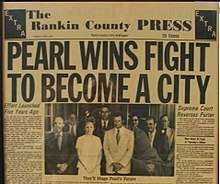
On September 16, 1968, a community meeting was held to discuss the incorporation of Pearl, with all but six of the 657 attending residents favoring incorporation.[6] A "Boundary Committee" proposed several possible boundaries a little more than a month later. The following January the community voted for an 11 square miles (28 km2) boundary that included the Pearl River to Airport Road, excluding East Jackson and all areas south of Interstate 20 except Cunningham Heights and Grandview Heights. A majority at that meeting also agreed to name the city "Pearl", rather than the alternative proposals of "Riverview" or "Brightsville".
Pearl was affected by the violence of the Ku Klux Klan,[7] and was white-only for most of the 20th Century. In 1970, Pearl had 9,613 white residents and 10 black residents.[8] By the 1990s Pearl had become more racially integrated, and by 2010 blacks made up 23% of the population.[9]
The first mayor, Harris Harvey, was elected, along with council members Jimmy Joe Thompson, W.D. McAlpin, James Netherland, Ophelia Byrd, Mack C Atwood, W.L. Maddox, and Bobby Joe Davis. With the Mississippi Supreme Court ruling of June 5, 1973, the incorporation could proceed. A week later, the state legislature issued a charter. On June 29, 1973, Governor William Winter presided over the first annual Pearl Day Celebration, with the swearing in of the city's new officials, who met for the first time on July 3, 1973.
The Pearl Municipal Separate School District was created on May 18, 1976, by an Ordinance of the City of Pearl Mayor and Board of Aldermen. The first franchise by the City of Pearl for cable television installation was granted on July 6, 1976. The Pearl Chamber of Commerce was formed on August 24, 1978.
On October 1, 1997, Luke Woodham went on a shooting spree that ended at Pearl High School, killing two and injuring seven, after earlier stabbing his mother to death.
Over the years the city has redeveloped the former Pearl High School into City Hall, including the Pearl Police Department, public works departments, and city courts. A large auditorium-style Community Center was built next door. Its clock tower is inscribed with the names of graduates of Pearl High School for the period 1949 through 1989 while the high school occupied the building. A 25,000 sq ft (2,300 m2) library opened near City Hall on July 18, 2005.
Geography
Pearl is located at 32°16′19″N 90°6′19″W (32.271979, -90.105266).[10]
According to the United States Census Bureau, the city has a total area of 22.0 square miles (57 km2), of which 21.8 square miles (56 km2) is land and 0.2 square miles (0.52 km2) (1.00%) is water. Neighboring towns include Flowood, Brandon, Richland and the state capital Jackson.
According to its 2008 Annual Drinking Water Quality Report, Pearl's drinking water comes from the Sparta Sand Aquifer via nine wells that draw the water from it.[11]
Demographics
| Historical population | |||
|---|---|---|---|
| Census | Pop. | %± | |
| 1980 | 18,602 | — | |
| 1990 | 19,588 | 5.3% | |
| 2000 | 21,961 | 12.1% | |
| 2010 | 25,092 | 14.3% | |
| Est. 2018 | 26,471 | [3] | 5.5% |
| U.S. Decennial Census[12] | |||
As of the census[4] of 2000, there were 21,961 people, 8,608 households, and 6,025 families residing in the city. The population density was 1,005.9 people per square mile (388.4/km²). There were 9,128 housing units at an average density of 418.1 per square mile (161.4/km²). The racial makeup of the city was 81.18% White, 16.24% African American, 0.22% Native American, 0.79% Asian, 0.03% Pacific Islander, 0.78% from other races, and 0.75% from two or more races. Hispanic or Latino of any race were 2.03% of the population.
There were 8,608 households out of which 34.4% had children under the age of 18 living with them, 50.2% were married couples living together, 15.6% had a female householder with no husband present, and 30.0% were non-families. 25.0% of all households were made up of individuals and 7.4% had someone living alone who was 65 years of age or older. The average household size was 2.55 and the average family size was 3.05.
In the city, the population was spread out with 26.4% under the age of 18, 10.1% from 18 to 24, 31.8% from 25 to 44, 21.4% from 45 to 64, and 10.3% who were 65 years of age or older. The median age was 34 years. For every 100 females, there were 90.8 males. For every 100 females age 18 and over, there were 86.6 males.
In the most recent census (2010), the racial demographics have changed similar to many other Jackson, MS area suburbs. The following are the most current demographics: White alone 69.8%, African American 23.0%, American Indian and Alaska Native 0.2%, Asian 0.9%, Native Hawaiian and Other Pacific Islander 0.2%, Two or More Races 1.7%, Hispanic 6.4%.
The median income for a household in the city was $37,617, and the median income for a family was $42,013. Males had a median income of $30,860 versus $24,610 for females. The per capita income for the city was $17,136. About 9.2% of families and 12.2% of the population were below the poverty line, including 17.3% of those under age 18 and 12.4% of those age 65 or over.
Government
Municipal government
The City of Pearl is led by an elected Mayor and Board of Aldermen. Each serves a four-year term.[13] Five of the six aldermen represent single-member districts; the sixth is elected at-large.
Law enforcement within the city limits of Pearl is handled by the Pearl Police Department. The City has no jail facilities and instead utilizes the Rankin County Jail, which is operated by the Rankin County Sheriff's Department.[13]
Fire protection and prevention within the city limits of Pearl is handled by the Pearl Fire Department. The department operates four stations throughout the city.[13]
State representation
The Mississippi Department of Corrections Central Mississippi Correctional Facility is in an unincorporated area in Rankin County, near Pearl.[14][15] In 2007 the Mississippi Highway Patrol opened a driver's license facility across the highway from the prison.[16]
The Mississippi Department of Environmental Quality operates the Central Regional Office and the MDEQ Laboratory in unincorporated Rankin County, near Pearl.[17][18]
Transportation
Air travel
Pearl is served by Jackson-Evers International Airport, located at Allen C. Thompson Field, at the Pearl city limits in the city of Flowood in Rankin County. Its IATA code is JAN. The airport has non-stop service to 12 cities throughout the United States and is served by five mainline carriers (American, Delta, Continental, Northwest, and US Airways).
Underway is the Airport Parkway project. The environmental impact study is complete and final plans are drawn and awaiting Mississippi Department of Transportation approval. Right-of-way acquisition is underway at an estimated cost of $19 million. The Airport Parkway will connect High Street in downtown Jackson to Mississippi Highway 475 in Flowood at Jackson-Evers International Airport. The Airport Parkway Commission consists of the Mayor of Pearl, the Mayor of Flowood and the Mayor of Jackson, as the Airport Parkway will run through and have access from each of these three cities.
Ground transportation
Interstate highways
![]()
Runs north-south from Chicago through Jackson towards Brookhaven, McComb, and the Louisiana state line to New Orleans. Pearl is roughly halfway between New Orleans and Memphis, Tennessee. The interstate connects to Interstate 20 in Jackson.
![]()
Runs east-west from near El Paso, Texas to Florence, South Carolina and is the main interstate to Pearl. Pearl is roughly halfway between Dallas, Texas and Atlanta, Georgia.
U.S. highways
![]()
Runs north-south from the Arkansas state line at Lula via Clarksdale and Yazoo City, towards Hattiesburg and dead ends at the Gulf of Mexico in Gulfport. From Gulfport going north back towards Jackson, this highway ends at Pearl where it is bypassed via Interstate 20 to Interstate 220 (I-220) to U.S. Highway 49 again towards Yazoo City.
![]()
Roughly parallels Interstate 20. It is the main corridor through the heart of Pearl.
State highways
![]()
This highway is known as Lakeland Drive in the metro-Jackson area and runs northeast towards Carthage and Starkville.
![]()
This highway runs from Mississippi Highway 25 in Flowood, though Pearl crossing U.S. Highway 80 and ends at Mississippi Highway 468.
Education
Colleges and universities
- Hinds Community College Rankin Campus (state two-year college)
The Rankin County campus of Hinds Community College opened in Pearl on July 1, 1983.
Primary and secondary schools
The City of Pearl's public schools are served by the Pearl Public School District whose Board is appointed by the City of Pearl Board of Aldermen.
- Pearl High School (Grades 9 through 12) Built in 1989; Expansions* in 1997, 2003 and 2005[13]
- Pearl Junior High School (Grades 6 through 8) Built in 1932; Expansions* in 1982, 1989, and 2004. They also rebuilt their gym throughout the 2012–2013 school year.[13]
- Pearl Upper Elementary (Grades 4 and 5) Built in 1965; Expansions* in 1999[13]
- Northside Elementary (Grades 2 and 3) Built in 1970; Expansions* in 1992, 1999 and 2007[13]
- Pearl Lower Elementary (Grades K and 1) Built in 1932; Expansions* in 1999 and 2005[13]
*Expansions include anything from adding a new wing or classrooms to adding new administrative offices to adding a press box to the baseball field.
Private schools
- Faith Academy - Grades Pre-kindergarten through 8 (served by the Midsouth Private School Association)
- Park Place Christian Academy - Grades Pre-kindergarten through 12. PPCA graduates its first senior class in May 2012.
Recreation
Pearl is home to many parks and recreational facilities.
- Center City Complex - softball, baseball, soccer, and offices of the Parks and Recreation Department (has been the site of several United States Specialty Sports Association Regional and National Tournaments)
- Pearl Activity Center (Old Boys Club) - baseball, meeting room, and gymnasium
- Bright Park - A 2/3 mile physical fitness walking trail through nature and picnic areas
- City Park - A family recreation area which includes, picnic areas, reserveable pavilion, children's playground, tennis courts, basketball court, and covered stage
- Jenkins Park - A family recreation facility, children's playground, picnic areas, pavilion, 1/2 mile walking trail, and softball field
- Old Library Walking Trail - A 1/4 mile walking trail
- Henry F. Shepherd Field Walking Trail - A 1/4 mile walking track around the old Pearl High School football field
- Center City Walking Trail - A 1-mile (1.6 km) walking trail winding through the scenic wooded terrain
- Pearl Municipal Golf Course - An 18-hole public golf course with a Club House and short order restaurant
Notable people
- Bianca Knight - Track athlete
- Tommy Aldridge - drummer
- Jimmy "Soybean" Henderson - guitarist for Black Oak Arkansas
- Justin Jenkins - NFL Buffalo Bills player
- George Kersh - athlete
- Ty Tabor - singer, guitarist for King's X[19]
- Eric Washington - former NBA player
Professional sports
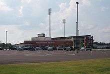
The Mississippi Braves or M-Braves, a Class AA minor league baseball affiliate of the Atlanta Braves moved from Greenville, South Carolina to Pearl before the 2005 season. The M-Braves play in the Southern League. The team had their first game in the brand new Trustmark Park on April 18, 2005, losing to the Montgomery Biscuits.
References
- "The City of Pearl Mississippi". The City of Pearl Mississippi. Retrieved October 10, 2012.
- "2017 U.S. Gazetteer Files". United States Census Bureau. Retrieved Jan 6, 2019.
- "Population and Housing Unit Estimates". Retrieved July 25, 2019.
- "U.S. Census website". United States Census Bureau. Retrieved 2008-01-31.
- "US Board on Geographic Names". United States Geological Survey. 2007-10-25. Retrieved 2008-01-31.
- "History of Pearl". cityofpearl.com. Archived from the original on April 26, 2009. Retrieved 2009-06-06.
- Lamkin, C.L. (2016). Perceptions of Segregation (M.Sc. thesis). University of Southern Mississippi. p. 97.
- Loewen, James (2005). Sundwon Towns: A Hidden Dimension of American Racism. New York, NY: New Press. p. 407. ISBN 978-1-56584-887-0.
- "Pearl city, Mississippi".
- "US Gazetteer files: 2010, 2000, and 1990". United States Census Bureau. 2011-02-12. Retrieved 2011-04-23.
- 2008 Annual Drinking Water Quality Report; City of Pearl; PWS ID# 0610017. City of Pearl Water Department. 2008.
- "Census of Population and Housing". Census.gov. Retrieved June 4, 2015.
- City of Pearl, Mississippi 2009 Comprehensive Plan; Pages 25-28; Accessed May 06, 2009
- "State Prisons Archived 2002-12-06 at the Wayback Machine." Mississippi Department of Corrections. Retrieved on May 21, 2010.
- "MDOC QUICK REFERENCE." Mississippi Department of Corrections. Retrieved on May 21, 2010.
- "New Driver's License Facility Opens In Pearl." WAPT-TV. April 23, 2007. Retrieved on May 21, 2010.
- "Central Regional Office." Mississippi Department of Environmental Quality. Retrieved on September 21, 2010.
- "Locations and Driving Directions to MDEQ Offices." Mississippi Department of Environmental Quality. Retrieved on September 21, 2010.
- MusicianGuide.com King's X Lyrics and Biography
External links
| Wikimedia Commons has media related to Pearl, Mississippi. |
| Wikivoyage has a travel guide for Pearl. |
- City of Pearl official web site
- Pearl Chamber of Commerce
- Pearl Public School District
- Pearl Pirates football official web site
- City-Data.com
- Central Mississippi Regional Library System
Places adjacent to Pearl, Mississippi | ||||||||||
|---|---|---|---|---|---|---|---|---|---|---|
| ||||||||||
Municipalities and communities of Rankin County, Mississippi, United States | ||
|---|---|---|
County seat: Brandon | ||
| Cities | 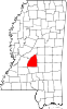 Map of Mississippi highlighting Rankin County | |
| Towns |
| |
| Village |
| |
| CDPs |
| |
| Unincorporated communities |
| |
| Ghost towns |
| |
| Footnotes | ‡This populated place also has portions in an adjacent county or counties | |
Jackson (capital) | ||
| Topics |
| .svg.png) Seal of Mississippi |
| Society |
| |
| Regions |
| |
| Metros |
| |
| Larger cities |
| |
| Smaller cities |
| |
| Counties |
| |
| Authority control |
|
|---|