El Paso, Texas
El Paso (/ɛl ˈpæsoʊ/; Spanish: [el ˈpaso] "the pass") is a city and the county seat of El Paso County, Texas, United States, in the far western part of the state. The 2018 population estimate for the city from the U.S. Census was 682,669, making it the 22nd largest city in the United States.[6] Its metropolitan statistical area (MSA) covers all of El Paso and Hudspeth counties in Texas, and has a population of 840,758.[6]
El Paso, Texas | |
|---|---|
| City of El Paso | |
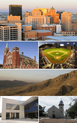 From top, left to right: El Paso skyline, Cathedral of Saint Patrick, Southwest University Park, Franklin Mountains, El Paso Museum of Art, Ysleta Mission | |
 Flag  Seal | |
| Nicknames: | |
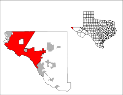 Location in El Paso County and the state of Texas | |
| Coordinates: 31°45′33″N 106°29′19″W | |
| Country | United States |
| State | Texas |
| County | El Paso |
| First settlement | 1680 |
| Settled as Franklin | 1849 |
| Renamed El Paso | 1852 |
| Town Laid out | 1859 |
| Incorporated | 1873 |
| Government | |
| • Type | Council–manager |
| • City Council | Mayor Dee Margo (R) Peter Svarzbein Alexsandra Annello Cassandra Hernandez Sam Morgan Isabel Salcido Claudia Ordaz Henry Rivera Cissy Lizarraga |
| • City manager | Tommy Gonzalez |
| Area | |
| • City | 256.3 sq mi (663.7 km2) |
| • Land | 255.3 sq mi (661.1 km2) |
| • Water | 1.0 sq mi (2.6 km2) |
| Elevation | 3,740 ft (1,140 m) |
| Population | 649,133 |
| • Estimate (2018)[4] | 682,669 (US: 22nd) |
| • Metro | 845,553 (US: 68th) |
| • CSA | 1,060,397(US: 54th) |
| Demonym(s) | El Pasoan |
| Time zone | UTC−07:00 (MST) |
| • Summer (DST) | UTC−06:00 (MDT) |
| ZIP Codes | 79900–79999 88500–88599 (PO Boxes) |
| Area codes | 915 |
| FIPS code | 48-24000 |
| GNIS feature ID | 1380946[5] |
| Primary Airport | El Paso International Airport ELP (Major/International) |
| Secondary Airport | Biggs Army Airfield- KBIF(Military) |
| Interstates | |
| U.S. Routes | |
| Website | www |
El Paso stands on the Rio Grande across the Mexico–United States border from Ciudad Juárez, the most populous city in the Mexican state of Chihuahua with 1.4 million people.[7] Las Cruces, in the neighboring U.S. state of New Mexico, has a population of 215,579.[8] On the U.S. side, the El Paso metropolitan area forms part of the larger El Paso–Las Cruces CSA, with a population of 1,060,397.[8]
Bi-nationally, these three cities form a combined international metropolitan area sometimes referred to as the Paso del Norte or the Borderplex. The region of 2.5 million people constitutes the largest bilingual and binational work force in the Western Hemisphere.[9]
The city is home to three publicly traded companies, and former Western Refining, now Andeavor.[10] as well as home to the Medical Center of the Americas,[11] the only medical research and care provider complex in West Texas and Southern New Mexico,[12] and the University of Texas at El Paso, the city's primary university. The city hosts the annual Sun Bowl college football post-season game, the second oldest bowl game in the country.[13]
El Paso has a strong federal and military presence. William Beaumont Army Medical Center, Biggs Army Airfield, and Fort Bliss are located in the area. Fort Bliss is one of the largest military complexes of the United States Army and the largest training area in the United States.[14] Also headquartered in El Paso are the DEA domestic field division 7, El Paso Intelligence Center, Joint Task Force North, United States Border Patrol El Paso Sector, and the U.S. Border Patrol Special Operations Group (SOG).
In 2010 and 2018, El Paso received an All-America City Award. El Paso ranked in the top three safest large cities in the United States between 1997 and 2014,[15] including holding the title of safest city between 2011 and 2014.[16]
History
Early years
The El Paso region has had human settlement for thousands of years, as evidenced by Folsom points from hunter-gatherers found at Hueco Tanks. The evidence suggests 10,000 to 12,000 years of human habitation.[17] The earliest known cultures in the region were maize farmers. When the Spanish arrived, the Manso, Suma, and Jumano tribes populated the area. These were subsequently incorporated into the Mestizo culture, along with immigrants from central Mexico, captives from Comanchería, and genízaros of various ethnic groups. The Mescalero Apache were also present.
Spanish explorer Don Juan de Oñate was born in 1550 in Zacatecas, Zacatecas, Mexico and was the first New Spain (Mexico) explorer known to have observed the Rio Grande near El Paso, in 1598,[18] celebrating a Thanksgiving Mass there on April 30, 1598 (decades before the English Pilgrims' Thanksgiving). However, the four survivors of the Narváez expedition, Álvar Núñez Cabeza de Vaca, Alonso del Castillo Maldonado, Andrés Dorantes de Carranza, and his enslaved Moor Estevanico, are thought to have passed through the area in the mid-1530s.[19] El Paso del Norte (present-day Ciudad Juárez) was founded on the south bank of the Río Bravo del Norte (Rio Grande), in 1659 by Fray Garcia de San Francisco. In 1680, the small village of El Paso became the temporary base for Spanish governance of the territory of New Mexico as a result of the Pueblo Revolt, until 1692 when Santa Fe was reconquered and once again became the capital.
The Texas Revolution (1836) was generally not felt in the region, as the American population was small; not being more than 10% of the population. However, the region was claimed by Texas as part of the treaty signed with Mexico and numerous attempts were made by Texas to bolster these claims. However, the villages which consisted of what is now El Paso and the surrounding area remained essentially a self-governed community with both representatives of the Mexican and Texan government negotiating for control until Texas irrevocably took control in 1846. During this interregnum, 1836–1848, Americans nonetheless continued to settle the region. As early as the mid-1840s, alongside long extant Hispanic settlements such as the Rancho de Juan María Ponce de León, Anglo settlers such as Simeon Hart and Hugh Stephenson had established thriving communities of American settlers owing allegiance to Texas. Stephenson, who had married into the local Hispanic aristocracy, established the Rancho de San José de la Concordia, which became the nucleus of Anglo and Hispanic settlement within the limits of modern-day El Paso, in 1844: the Republic of Texas, which claimed the area, wanted a chunk of the Santa Fe trade. The Treaty of Guadalupe Hidalgo effectively made the settlements on the north bank of the river part of the US, separate from Old El Paso del Norte on the Mexican side.[20] The present Texas–New Mexico boundary placing El Paso on the Texas side was drawn in the Compromise of 1850.
El Paso remained the largest settlement in New Mexico as part of the Republic of Mexico until its cession to the U.S. in 1848, when the Treaty of Guadalupe Hidalgo specified the border was to run north of El Paso De Norte around the Ciudad Juárez Cathedral which became part of the state of Chihuahua.
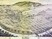
El Paso County was established in March 1850, with San Elizario as the first county seat. The United States Senate fixed a boundary between Texas and New Mexico at the 32nd parallel, thus largely ignoring history and topography. A military post called "The Post opposite El Paso" (meaning opposite El Paso del Norte, across the Rio Grande) was established in 1849 on Coons' Rancho beside the settlement of Franklin, which became the nucleus of the future El Paso, Texas; After the army left in 1851 the rancho went into default and was repossessed; in 1852 a post office was established on the rancho bearing the name El Paso as an example of Cross-border town naming until El Paso del Norte was renamed Juarez in 1888. After changing hands twice more the El Paso company was set up in 1859 and bought the property, hiring Anson Mills to survey and lay out the town forming the current street plan of downtown El Paso.[21]
During the Civil War, a Confederate presence was in the area until it was captured by the Union California Column in 1862. It was then headquarters for the 5th Regiment California Volunteer Infantry until December 1864.[22]
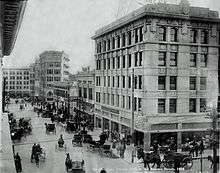
After the Civil War's conclusion, the town's population began to grow as Texans continued to move into the villages and soon became the majority. El Paso itself, incorporated in 1873, encompassed the small area communities that had developed along the river. In the 1870s, a population of 23 non-Hispanic whites and 150 Hispanics was reported.[23] With the arrival of the Southern Pacific, Texas and Pacific and the Atchison, Topeka and Santa Fe railroads in 1881, the population boomed to 10,000 by the 1890 census, with many Anglo-Americans, recent immigrants, old Hispanic settlers, and recent arrivals from Mexico. The location of El Paso as well as the arrival of these more wild newcomers caused the city to become a violent and wild boomtown known as the "Six Shooter Capital" because of its lawlessness.[21] Indeed, prostitution and gambling flourished until World War I, when the Department of the Army pressured El Paso authorities to crack down on vice (thus benefitting vice in neighboring Ciudad Juárez). With the suppression of the vice trade and in consideration of the city's geographic position, the city continued into developing as a premier manufacturing, transportation, and retail center of the U.S. Southwest.
1900–present

In 1909, William Howard Taft and Porfirio Díaz planned a summit in El Paso, Texas, and Ciudad Juárez, Mexico, a historic first meeting between a U.S. president and a Mexican president and also the first time an American president would cross the border into Mexico[24] But tensions rose on both sides of the border, including threats of assassination, so the Texas Rangers, 4,000 U.S. and Mexican troops, U.S. Secret Service agents, FBI agents and U.S. marshals were all called in to provide security.[25] Frederick Russell Burnham, the celebrated scout, was put in charge of a 250 private security detail hired by John Hays Hammond, who in addition to owning large investments in Mexico was a close friend of Taft from Yale and a U.S. Vice-Presidential candidate in 1908.[26][27] On October 16, the day of the summit, Burnham and Private C.R. Moore, a Texas Ranger, discovered a man holding a concealed palm pistol standing at the El Paso Chamber of Commerce building along the procession route.[28][29] Burnham and Moore captured, disarmed, and arrested the assassin within only a few feet of Taft and Díaz.[30][31]By 1910, the overwhelming number of people in the city were Americans creating a settled environment. However, this period was short-lived as the Mexican Revolution greatly impacted the city, bringing an influx of refugees – and capital – to the bustling boom town. Spanish-language newspapers, theaters, movie houses, and schools were established, many supported by a thriving Mexican refugee middle class. Large numbers of clerics, intellectuals, and businessmen took refuge in the city, particularly between 1913 and 1915. Ultimately, the violence of the Mexican Revolution followed with the large Mexican diaspora which had fled into El Paso. In 1915 and again in 1916 and 1917 various Mexican revolutionary societies planned, staged, and launched violent attacks against both Texans and their political Mexican opponents in El Paso. This state of affairs eventually led to the vast Plan de San Diego which resulted in the murder of 21 American citizens.[32] The subsequent reprisals by local militia soon caused an escalation of violence, wherein it is estimated that approximately 300 Mexicans and Mexican-Americans lost their lives. These actions affected almost every resident of the entire lower Rio Grande Valley, resulting in millions of dollars of losses; the end result of the Plan of San Diego was long-standing enmity between the two ethnic groups.[32]
Simultaneously, other Texans and Americans gravitated to the city and by 1920, along with the U.S. Army troops, the population exceeded 100,000 and Non-Hispanic whites once again were in the clear majority. Nonetheless, the city increased the segregation between Mexicans and Mexican-Americans with Non-Hispanic whites. In reply, the Catholic Church attempted to garner the Mexican-American community's allegiance through education and political and civic involvement organizations, including the National Catholic Welfare Fund.[33] In 1916, the Census Bureau reported El Paso's population as 53% Mexican and 44% Non-Hispanic whites.[34] Mining and other industries gradually developed in the area. The El Paso and Northeastern Railway was chartered in 1897, to help extract the natural resources of surrounding areas, especially in southeastern New Mexico Territory. The 1920s and 1930s saw the emergence of major business development in the city, partially enabled by Prohibition-era bootlegging.[21] However, the military demobilization, and an agricultural economic depression which hit places like El Paso first before the larger Great Depression was felt in the big cities, hit the city hard. In turn, as in the rest of the United States, the Depression era overall hit the city hard, and El Paso's population declined through the end of World War II with most of population losses coming from the Non-Hispanic white community. Nonetheless, Non-Hispanic whites remained the majority to the 1940s.
During and following the war, military expansion in the area, as well as oil discoveries in the Permian Basin (North America), helped to engender rapid economic expansion in the mid-1900s. Copper smelting, oil refining, and the proliferation of low-wage industries (particularly garment making) led the city's growth. Additionally, the departure of region's rural population, which was mostly Non-Hispanic white, to cities like El Paso, brought a short term burst of capital and labor. However, this was balanced by additional departures of middle class Americans to other parts of the country which offered new and better paying jobs. In turn, local businesses looked south to the opportunities afforded by cheap Mexican labor. Furthermore, the period from 1942 to 1956 saw the bracero program which brought in cheap Mexican labor into the rural area to replace the losses of the Non-Hispanic white population. In turn, seeking better-paying jobs these migrants also moved to El Paso. By 1965, Hispanics once again were a majority. Meanwhile, the post-war expansion slowed again in the 1960s, but the city continued to grow with the annexation of surrounding neighborhoods and in large part because of its significant economic relationship with Mexico.
The Farah Strike, 1972–1974, occurred in El Paso, Texas. This strike was originated and led by Chicanas, or Mexican American women, due to Farah Manufacturing Company, one of the largest factories in the city, being unorganized, low wages, discrimination, no benefits, lack of gender-neutrality, health and safety hazards, and unattainable quotas.[35] Texas Monthly described the Farah Strike as the "strike of the century."[36]
On August 3, 2019, a mass shooting/domestic terrorist attack committed by a white supremacist occurred at a Walmart in El Paso, which left 22 people dead and 24 others injured.[37][38]
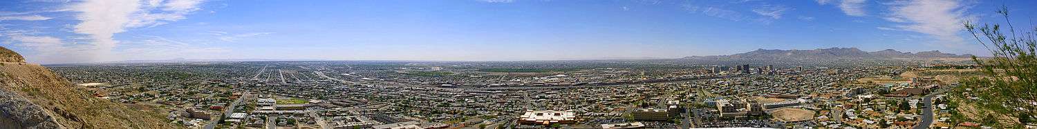
Geography
El Paso is located at the intersection of three states (Texas, New Mexico, and Chihuahua) and two countries (the U.S. and Mexico). It is the only major Texas city on Mountain Time. Ciudad Juarez was once in Central Time,[39] but both cities are now on Mountain Time.
El Paso is closer to the capital cities of four other states – Phoenix, Arizona (345 miles (555 km) away);[40] Santa Fe, New Mexico, (273 miles (439 km) away);[41] Ciudad Chihuahua, Chihuahua, (218 miles (351 km) away),[42] and Hermosillo, Sonora (325 miles (523 km) away)[43] – than it is to the capital of its own state, Austin (528 miles (850 km) away).[44] It is closer to Los Angeles, California (700 miles (1,100 km) away)[45] than it is to Orange (858 miles (1,381 km) away),[46] the easternmost town in the state.
El Paso is located within the Chihuahuan Desert, the easternmost section of the Basin and Range Region. The Franklin Mountains extend into El Paso from the north and nearly divide the city into two sections; the west side forms the beginnings of the Mesilla Valley, and the east side expands into the desert and lower valley. They connect in the central business district at the southern end of the mountain range.
The city's elevation is 3,800 ft (1,200 m) above sea level. North Franklin Mountain is the highest peak in the city at 7,192 ft (2,192 m) above sea level. The peak can be seen from 60 mi (100 km) in all directions. Additionally, this mountain range is home to the famous natural red-clay formation, the Thunderbird, from which the local Coronado High School gets its mascot's name. According to the United States Census Bureau, the city has a total area of 256.3 square miles (663.7 km2).[47]
The 24,000-acre (9,700 ha) Franklin Mountains State Park, the largest urban park in the United States, lies entirely in El Paso, extending from the north and dividing the city into several sections along with Fort Bliss and El Paso International Airport.
The Rio Grande Rift, which passes around the southern end of the Franklin Mountains, is where the Rio Grande flows. The river defines the border between El Paso and Ciudad Juárez to the south and west until the river turns north of the border with Mexico, separating El Paso from Doña Ana County, New Mexico. Mt. Cristo Rey, an example of a pluton, rises within the Rio Grande Rift just to the west of El Paso on the New Mexico side of the Rio Grande. Nearby volcanic features include Kilbourne Hole and Hunt's Hole, which are Maar volcanic craters 30 miles (50 km) west of the Franklin Mountains.
Climate
El Paso has a transitional climate between cold desert climate (Köppen BWk) and hot desert climate (Köppen BWh) featuring hot summers, with little humidity, and cool to mild dry winters. Rainfall averages 9.7 in (250 mm) per year, much of which occurs during the summer from July through September, and is predominantly caused by the North American Monsoon. During this period, southerly and southeasterly winds carry moisture from the Pacific, the Gulf of California, and the Gulf of Mexico into the region. When this moisture moves into the El Paso area and places to the southwest, orographic lift from the mountains, combined with strong daytime heating, causes thunderstorms, some severe enough to produce flash flooding and hail, across the region.
The sun shines 302 days per year on average in El Paso, 83% of daylight hours, according to the National Weather Service; from this, the city is nicknamed "The Sun City".[48] Due to its arid, windy climate, El Paso often experiences sand and dust storms during the dry season, particularly during the springtime between March and early May. With an average wind speed often exceeding 30 mph (50 km/h) and gusts that have been measured at over 75 mph (120 km/h), these wind storms kick up large amounts of sand and dust from the desert, causing loss of visibility.
El Paso and the nearby mountains also receive snow. Weather systems have produced over one foot (30 cm) of snow on several occasions. In the 1982–1983 winter season, three major snowstorms produced record seasonal snowfall. On December 25–26, 1982, 6.0 inches (15 cm) of snow fell, producing a white Christmas for the city.[49] This was followed by another 7.0 inches (18 cm) on December 30–31, 1982. On April 4–7, 1983, 16.5 inches (42 cm) of snow fell on El Paso, bringing the seasonal total to nearly 30 inches (76 cm). On December 13–14, 1987, a record storm dumped over 22 inches (56 cm) of snow on El Paso, and two weeks later (December 25–26), another three inches (7.6 cm) fell, bringing the monthly total for December 1987 to an all-time record high of 25.9 inches (66 cm)[50] of snow.[51] The average annual snowfall for the city varies widely between different neighborhoods at different elevations, but is 6.1 inches (15 cm) at the airport (but with a median of 0, meaning most years see no snow at all).[52] Snow is most rare around Ysleta and the eastern valley area, which usually include large numbers of palm trees; in the higher neighborhoods, palm trees are more vulnerable to snow and cold snaps and are often seen with brown, frost-damaged fronds.
One example of El Paso's varying climate at its most extreme was the damaging winter storm of early February 2011, which caused closures of schools, businesses, and City Hall. The snow, which was light, stopped after about a day, but during the ensuing cold episode, municipal utilities went into a crisis. The high temperature on February 2, 2011 was 15 °F (−9 °C), the lowest daily maximum on record. In addition, the low temperature on February 3 was 1 °F (−17 °C), breaking the 5 °F (−15 °C) monthly record low set during the cold wave of 1899.[49] Loss of desert vegetation, such as Mexican/California palm trees, oleanders, and iceplants to the cold weather was one of the results. Two local power plants failed, forcing El Paso Electric to institute rolling blackouts over several days,[53] and electric wires were broken, causing localised blackouts. Many water utility pipes froze, causing areas of the city to be without water for several days.
Monthly means range from 45.5 °F (7.5 °C) in December to 83.5 °F (28.6 °C) in July, but high temperatures typically peak in June before the monsoon arrives, while daily low temperatures typically peak in July or early August with the higher humidity the monsoon brings (translating to warmer nights). On average, there are 52 nights of at- or below-freezing lows, 109 days of 90 °F (32 °C)+ highs and 20 days of 100 °F (38 °C)+ highs annually; it is extremely rare for temperatures to stay below the freezing mark all day.[51] The city's record high is 114 °F (46 °C) on June 30, 1994, and its record low is −8 °F (−22 °C) on January 11, 1962; the highest daily minimum was 85 °F (29 °C) on July 1 and 3, 1994, with weather records for the area maintained by the National Weather Service since 1879.
Flooding
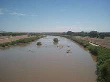
Although the average annual rainfall is only about 9.7 in (250 mm), many parts of El Paso are subject to occasional flooding during intense summer monsoonal thunderstorms. In late July and early August 2006, up to 10 in (250 mm) of rain fell in a week, the flood-control reservoirs overflowed and caused major flooding citywide.[54] The city staff estimated damage to public infrastructure at $21 million, and to private property (residential and commercial) at $77 million.[55] Much of the damage was associated with development in recent decades in arroyos protected by flood-control dams and reservoirs, and the absence of any storm drain utility in the city to handle the flow of rain water.
| Climate data for El Paso Int'l, Texas (1981–2010 normals, extremes 1879–present)[lower-alpha 1] | |||||||||||||
|---|---|---|---|---|---|---|---|---|---|---|---|---|---|
| Month | Jan | Feb | Mar | Apr | May | Jun | Jul | Aug | Sep | Oct | Nov | Dec | Year |
| Record high °F (°C) | 80 (27) |
86 (30) |
93 (34) |
98 (37) |
105 (41) |
114 (46) |
112 (44) |
108 (42) |
104 (40) |
96 (36) |
87 (31) |
80 (27) |
114 (46) |
| Average high °F (°C) | 57.7 (14.3) |
63.1 (17.3) |
70.3 (21.3) |
78.6 (25.9) |
87.8 (31.0) |
95.5 (35.3) |
94.7 (34.8) |
92.4 (33.6) |
87.6 (30.9) |
78.2 (25.7) |
66.2 (19.0) |
57.1 (13.9) |
77.4 (25.2) |
| Daily mean °F (°C) | 45.1 (7.3) |
50.1 (10.1) |
56.6 (13.7) |
64.7 (18.2) |
73.9 (23.3) |
82.0 (27.8) |
82.8 (28.2) |
81.0 (27.2) |
75.5 (24.2) |
65.1 (18.4) |
53.2 (11.8) |
44.8 (7.1) |
64.5 (18.1) |
| Average low °F (°C) | 32.5 (0.3) |
37.1 (2.8) |
42.9 (6.1) |
50.7 (10.4) |
60.0 (15.6) |
68.0 (20.0) |
70.9 (21.6) |
69.7 (20.9) |
63.3 (17.4) |
52.0 (11.1) |
40.1 (4.5) |
32.5 (0.3) |
51.6 (10.9) |
| Record low °F (°C) | −8 (−22) |
1 (−17) |
14 (−10) |
23 (−5) |
31 (−1) |
46 (8) |
56 (13) |
52 (11) |
41 (5) |
25 (−4) |
1 (−17) |
−5 (−21) |
−8 (−22) |
| Average precipitation inches (mm) | 0.40 (10) |
0.46 (12) |
0.26 (6.6) |
0.23 (5.8) |
0.47 (12) |
0.94 (24) |
1.55 (39) |
2.01 (51) |
1.51 (38) |
0.61 (15) |
0.49 (12) |
0.78 (20) |
9.71 (247) |
| Average snowfall inches (cm) | 1.3 (3.3) |
0.6 (1.5) |
0.3 (0.76) |
0.8 (2.0) |
0 (0) |
0 (0) |
0 (0) |
0 (0) |
0 (0) |
trace | 0.8 (2.0) |
3.1 (7.9) |
6.9 (18) |
| Average precipitation days (≥ 0.01 in) | 3.8 | 3.4 | 2.4 | 1.9 | 2.7 | 3.9 | 8.3 | 8.7 | 6.3 | 4.7 | 3.1 | 3.9 | 53.1 |
| Average snowy days (≥ 0.1 in) | 1.0 | 0.4 | 0.1 | 0.2 | 0 | 0 | 0 | 0 | 0 | 0.1 | 0.3 | 1.1 | 3.2 |
| Average relative humidity (%) | 50.5 | 41.6 | 32.4 | 26.9 | 27.1 | 29.9 | 43.9 | 48.4 | 50.5 | 47.1 | 46.1 | 51.5 | 41.3 |
| Mean monthly sunshine hours | 254.5 | 263.0 | 326.0 | 348.0 | 384.7 | 384.1 | 360.2 | 335.4 | 304.1 | 298.6 | 257.6 | 246.3 | 3,762.5 |
| Percent possible sunshine | 80 | 85 | 88 | 89 | 90 | 90 | 83 | 81 | 82 | 85 | 82 | 79 | 85 |
| Source: NOAA (relative humidity 1962–1990, sun 1961–1990)[49][56][57] | |||||||||||||
Time zone
El Paso is located in the far western corner of Texas, which is roughly the only part of the state that is located within the Mountain Time Zone, as opposed to the Central Time Zone.
Neighborhoods
Downtown and central El Paso
This part of town contains some of the city's oldest and most historic neighborhoods. Located in the heart of the city, it is home to approximately 44,993 people.[58] Development of the area started in 1827 with the first resident, Juan Maria Ponce de Leon, a wealthy merchant from Paso del Norte (present day Ciudad Juárez), who built the region's first structure establishing Rancho Ponce within the vicinity of S. El Paso Street and Paisano Dr. when the city was barely beginning to gain its roots. Today, central El Paso has grown into the center of the city's economy and a thriving urban community. It contains numerous historic sites and landmarks mostly in the Sunset Heights district. It is close to the El Paso International Airport, the international border, and Fort Bliss. It is part of the El Paso Independent School District.
Dr. James Day, an El Paso historian, said that downtown's main business area was originally centered between Second Avenue (now Paisano Drive) and San Francisco Avenue. At a later point the main business area was centered around Stanton Street and Santa Fe Street. In the late 1800s most of the white American residents lived to the north of the non-white areas, living in brick residences along Magoffin, Myrtle, and San Antonio Avenues. Hispanic-American residents lived in an area called Chihuahuita ("little Chihuahua"), which was located south of Second Avenue and west of Santa Fe Street. Several African Americans and around 300 Chinese Americans also lived in Chihuahuita. Many of the Chinese Americans participated in the building of railroads in the El Paso area.[59] Another downtown neighborhood is El Segundo Barrio, which is near the United States/Mexico border.[60]
Northwest El Paso
Better known as West El Paso or the West Side, the area includes a portion of the Rio Grande floodplain upstream from downtown which is known locally as the Upper Valley and is located on the west side of the Franklin Mountains. The Upper Valley is the greenest part of the county due to the Rio Grande. The west side is home to some of the most affluent neighborhoods within the city, such as the Coronado Hills and Country Club neighborhoods. It is one of the fastest-growing areas of El Paso.
West central El Paso
West central El Paso is located north of Interstate 10 and west of the Franklin Mountains. The University of Texas at El Paso and the Cincinnati Entertainment district are located in the heart of the area. Historic districts Kern Place and Sunset Heights are in this part of town.
Kern Place was founded in 1914 by Peter E. Kern, for whom the neighborhood was named.[61]
The homes of Kern Place are unique in architecture and some were built by residents themselves.[61] One of the better known homes is the Paul Luckett Home located at 1201 Cincinnati Ave. above Madeline Park, and is made of local rock. It is known as "The Castle" due to its round walls and a crenelated rooftop.[61]
Kern Place is extremely popular with college and university students. The area is known for its glitzy entertainment district, restaurants and coffee shops who cater to both business patrons and university students.[62][63] After UTEP's basketball and football games, UTEP fans pack the Kern Place area for food and entertainment at Cincinnati Street a small bar district. This bar scene has grown over the years and has attracted thousands to its annual Mardi Gras block party as well as after sporting events or concerts. Young men and women make up the majority of the crowds who stop in between classes or after work.
Sunset Heights is one of the most historic areas in town, which has existed since the latter part of the 1890s. Many wealthy residents have had their houses and mansions built on this hill. Although some buildings have been renovated to their former glory, but many have been neglected and have deteriorated. During the Mexican Revolution, a widely popular Mexican revolutionary leader, Doroteo Arango (also known as Francisco "Pancho" Villa), owned and resided in this area during the 1910s.[64] During the 1910 Mexican Revolution many Mexicans fled Mexico and settled in Sunset Heights.[65]
Northeast El Paso
This part of town is located north of central El Paso and east of the Franklin Mountains. Development of the area was extensive during the 1950s and 1960s. It is one of the more ethnically diverse areas in the city due to the concentration of military families. The Northeast has not developed as rapidly as other areas like east El Paso and northwest El Paso, but its development is steadily increasing. It is expected that the population will grow more rapidly as a result of the troop increase at Ft. Bliss in the coming years. The area has also gained recognition throughout the city for the outstanding high school athletic programs at Andress High School, Parkland High School, Irvin High School, and Chapin High School.
East El Paso
The area is located north of Interstate 10, east of Airway Blvd., and south of Montana Ave. It is the largest and fastest growing area of town with a population of over 200,000.[66] It includes the 79936 ZIP Code, which was considered in 2013 as the most populous in the nation with over 114,000 people.[67]
Mission Valley
Formerly known as the lower valley, it includes part of Eastside and all lower valley districts. It is the third largest area of the city, behind east El Paso and central El Paso. Hawkins Road and Interstate 10 border the Mission Valley. This location is considered the oldest area of El Paso, dating back to the late 17th century when present-day Texas was under the rule of Nueva España (New Spain).
In 1680 the Isleta Pueblo tribe revolted against the Spaniards who were pushed south to what is now El Paso. Some Spaniards and tribe members settled here permanently. Soon afterward, three Spanish missions were built; they remain standing, currently functioning as churches: Ysleta Mission-1682 (La Misión de Corpus Christi y de San Antonio de la Ysleta del Sur/Our Lady of Mt. Carmel), Socorro Mission-1759 (Nuestra Señora de la Purísima Concepción del Socorro)-1759 and San Elizario Chapel (Capilla de San Elcear)-1789.
On April 30, 1598, the northward-bound Spanish conquistadors crossed large sand dunes about 27 miles south of present-day downtown El Paso. It is said that the expeditionaries and their horses ran toward the river, and two horses drank themselves to death. Don Juan de Oñate, a New Spain-born conquistador of Spanish parents, was an expedition leader who ordered a big feast north of the Río Grande in what is now San Elizario. This was the first documented and true Thanksgiving in North America. Oñate declared La Toma (taking possession), claiming all territory north of the Río Grande for King Philip II of Spain.
Ysleta Del Sur Pueblo (related to the insurgent Isleta Pueblo Tribe) is also located in this valley. The Tigua (pronounced Tiwa) is one of three Indian tribes in Texas whose sovereignty is recognized by the United States government. Ysleta is spelled with a "Y" because 19th-century script did not differentiate between a capital "Y" and a capital "I."
Some people in this area and its twin city across the river, Ciudad Juárez, are direct descendants of the Spaniards.
Texas and New Mexico suburbs
El Paso is surrounded by many cities and communities in both Texas and New Mexico. The most populated suburbs in Texas are Socorro, Horizon City, Fort Bliss and San Elizario. Other Texas suburbs are Anthony, Canutillo, Sparks, Fabens, and Vinton.
Although Anthony, Santa Teresa, Sunland Park, and Chaparral lie adjacent to El Paso County, they are considered to be part of the Las Cruces, New Mexico metropolitan area by the United States Census Bureau.[68]
Cityscape
Tallest buildings

| Rank | Building | Height | Floors | Built | |
|---|---|---|---|---|---|
| 1 | Wells Fargo Plaza | 302 ft (92 m)[69] | 21 | 1971 | |
| 2 | One San Jacinto Plaza | 280 ft (85 m)[70] | 20 | 1962 | |
| 3 | Stanton Tower | 260 ft (79 m)[70] | 18 | 1982 | |
| 4 | Plaza Hotel | 246 ft (75 m) | 19 | 1930 | |
| 5 | Hotel Paso del Norte Tower | 230 ft (70 m) | 17 | 1986 | |
| 6 | El Paso County Courthouse | 230 ft (70 m) | 14[71] | 1991 | |
| 7 | Blue Flame Building | 230 ft (70 m) | 18 | 1954 | |
| 8 | O. T. Bassett Tower – Aloft Hotel | 216 ft (66 m) | 15 | 1930 | |
| 9 | One Texas Tower | 205 ft (62 m) | 15 | 1921 | |
| 10 | Albert Armendariz Sr. U.S. Federal Courthouse | 205 ft (62 m) | 9 [72] | 2010 |
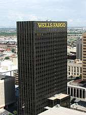
El Paso's tallest building, the Wells Fargo Plaza, was built in the early 1970s as State National Plaza. The black-windowed, 302-foot (92 m)[69] building is famous for its 13 white horizontal lights (18 lights per row on the east and west sides of the building, and seven bulbs per row on the north and south sides) that were lit at night. The tower did use a design of the United States flag during the July 4 holidays, as well as the American hostage crisis of 1980, and was lit continuously following the September 11 attacks in 2001 until around 2006. During the Christmas holidays, a design of a Christmas tree was used, and at times, the letters "UTEP" were used to support University of Texas at El Paso athletics. The tower is now only lit during the holiday months, or when special events take place in the city.
Demographics
| Historical population | |||
|---|---|---|---|
| Census | Pop. | %± | |
| 1850 | 200 | — | |
| 1860 | 428 | 114.0% | |
| 1880 | 736 | — | |
| 1890 | 10,338 | 1,304.6% | |
| 1900 | 15,906 | 53.9% | |
| 1910 | 39,279 | 146.9% | |
| 1920 | 77,560 | 97.5% | |
| 1930 | 102,421 | 32.1% | |
| 1940 | 96,810 | −5.5% | |
| 1950 | 130,485 | 34.8% | |
| 1960 | 276,687 | 112.0% | |
| 1970 | 339,615 | 22.7% | |
| 1980 | 425,259 | 25.2% | |
| 1990 | 515,342 | 21.2% | |
| 2000 | 563,662 | 9.4% | |
| 2010 | 649,121 | 15.2% | |
| Est. 2018 | 682,669 | [6] | 5.2% |
| U.S. Decennial Census[73] Texas Almanac: 1850–2000[74] 2018 Estimate[75] El Paso 1850 to 2006[76] TX State Historical Association[77] | |||
| Demographic profile | 2017[78] | 2010[79] | 2000[80] | 1990[81] | 1970[81] |
|---|---|---|---|---|---|
| White | 92.0% | 80.8% | 76.3% | 76.9% | 96.7% |
| —Non-Hispanic whites | 11.8% | 14.2% | 18.3% | 26.4% | 40.4%[82] |
| African American or Black | 3.9% | 3.4% | 3.5% | 3.4% | 2.3% |
| Hispanic or Latino (of any race) | 82.8% | 80.7% | 76.6% | 69.0% | 57.3%[82] |
| Asian | 1.3% | 1.2% | 1.5% | 1.2% | 0.3% |
.png)
As of 2010 U.S. census, 649,121 people, 216,694 households, and 131,104 families resided in the city. The population density was 2,263.0 people per square mile (873.7/km²). There were 227,605 housing units at an average density of 777.5 per square mile (300.2/km²). Recent census estimates say that the racial composition of El Paso is: White– 92.0% (Non-Hispanic Whites: 11.8%), African American or Black – 3.9%, Two or more races – 1.5%, Asian – 1.3%, Native American – 1.0%, and Native Hawaiian and other Pacific Islander – 0.2%.[83] There are no de facto African-American neighborhoods.[84]
Ethnically, the city was: 82.8% Hispanic or Latino of any race.
There were 216,894 households in 2010, out of which 37.6% had children under the age of 18 living with them, 48.5% were married couples living together, 20.7% had a female householder with no husband present, and 25.3% were not families. About 21.5% of all households were made up of individuals, and 24.9% had someone living alone who was 65 years of age or older. The average household size was 2.95 and the average family size was 3.47
In the city, the population was distributed as 29.1% under the age of 18, 7.5% from 20 to 24, 26.2% from 25 to 44, 22.8% from 45 to 64, and 11.1% who were 65 years of age or older. The median age was 32.5 years.
The median income for a household in the city was $44,431, and for a family was $50,247. Males had a median income of $28,989 versus $21,540 for females. The per capita income for the city was $21,120. About 17.3% of families and 20.3% of the population were below the poverty line, including 28.5% of those under age 18 and 18.4% of those age 65 or over.
Economy
| Largest Employers in El Paso[85] | |
|---|---|
| 1 | Fort Bliss |
| 2 | El Paso Independent School District |
| 3 | City of El Paso |
| 4 | Ysleta Independent School District |
| 5 | T & T Staff Management L.P.[86] |
| 6 | Tenet Healthcare |
| 7 | University of Texas at El Paso |
| 8 | El Paso Healthcare System, LTD. |
| 9 | El Paso County |
| 10 | El Paso Community College |
| 11 | U.S. Customs and Border Protection |
| 12 | Automatic Data Processing, Inc. |
| 13 | University Medical Center |
| 14 | Dish Network |
| 15 | Texas Tech University Health Sciences Network |
El Paso has a diversified economy focused primarily within international trade, military, government civil service, oil and gas, health care, tourism and service sectors. The El Paso metro area had a GDP of $29.03 billion in 2017.[87] There was also $92 billion worth of trade in 2012.[88] Over the past 15 years the city has become a significant location for American-based call centers. Cotton, fruit, vegetables, and livestock are also produced in the area. El Paso has added a significant manufacturing sector with items and goods produced that include petroleum, metals, medical devices, plastics, machinery, defense-related goods and automotive parts. The city is the second busiest international crossing point in the U.S. behind San Diego.[89]
El Paso is home to one Fortune 500 company, Western Refining, which is listed on the New York Stock Exchange.[90] This makes the city one of six Texas metro areas to have at least one Fortune 500 company call it home; the others being Houston, Dallas-Fort Worth, San Antonio, Austin and Corpus Christi.[91] The second publicly traded company is Helen of Troy Limited, a NASDAQ-listed company that manufactures personal health care products under many labels, such as OXO, Dr. Scholl's, Vidal Sassoon, Pert Plus, Brut and Sunbeam, and the third is El Paso Electric listed on the New York Stock Exchange, a public utility engaging in the generation, transmission, and distribution of electricity in west Texas and southern New Mexico. The fourth publicly traded company is Western Refining Logistics also traded in the New York Stock Exchange. It is a Western Refining subsidiary which owns, operates, develops, and acquires terminals, storage tanks, pipelines, and other logistics assets.
More than 70 Fortune 500 companies have offices in El Paso, including AT&T, ADP, Boeing, Charles Schwab, Delphi, Dish Network, Eureka, Hoover, Raytheon, Prudential Financial, USAA and Verizon Wireless.[92][93] Hispanic Business Magazine included 28 El Paso companies in its list of the 500 largest Hispanic owned businesses in the United States.[94] El Paso's 28 companies are second only to Miami's 57. The list of the largest Hispanic owned businesses includes companies like Fred Loya Insurance, a Hispanic 500 company and the 18th largest Hispanic business in the nation. Other companies on the list are Dos Lunas Spirits, Dynatec Labs, Spira Footwear, Datamark, Inc. and El Taco Tote. El Paso was home to El Paso Corporation formerly known as El Paso Natural Gas Company.
The city also has a large military presence with Fort Bliss, William Beaumont Army Medical Center and Biggs Army Airfield. The defense industry in El Paso employs over 41,000 and provides a $6 billion annual impact to the city's economy.[95] In 2013, Fort Bliss was chosen as the newly configured U.S. Air Force Security Forces Regional Training Center which added 8,000 to 10,000 Air Force personnel annually.[96]
In addition to the military, the federal government has a strong presence in El Paso to manage its status and unique issues as an important border region. Operations headquartered in El Paso include the DEA domestic field division 7, El Paso Intelligence Center, Joint Task Force North, U.S. Border Patrol El Paso Sector and U.S. Border Patrol Special Operations Group (SOG).
Call center operations employ more than 10,000 people in the area. Automatic Data Processing has an office in West El Paso, employing about 1,100 people with expansion plans to reach 2,200 by 2020.[97]
Tourism is another major industry in El Paso, bringing in $1.5 billion-a-year and over 2.3 million visitors annually due to the city's sunny weather, natural beauty, rich cultural history and many outdoor attractions.[98]
Education is also a driving force in El Paso's economy. El Paso's three large school districts are among the largest employers in the area, employing more than 20,000 people among them. UTEP has an annual budget of nearly $418 million and employs nearly 4,800 people.[99][100] A 2010 study by the university's Institute for Policy and Economic Development stated the university's impact on local businesses is $417 million annually.[101]
Arts and culture
Annual cultural events and festivals
Amigo Airsho
Amigo Airsho is one of El Paso's premier events, and is ranked as one of the top ten air shows in the country. The show is filled with air entertainment and ground activities. Acts include the Franklin's Flying Circus, where performers walk on the wings of an airborne plane. Ground activities include the Jet Powered School Bus. After 31 years of being held at Biggs Army Airfield, the show was moved to Dona Ana Airport in 2014.[102]
KLAQ Great River Raft Race
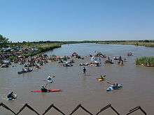
The KLAQ Great River Raft Race is an annual event celebrated on the second to last Saturday of June. Participants are encouraged to ride the river and float the Rio Grande with family and friends. The organizers encourage the building of unique rafts that will get you down the river with prizes and trophies awarded for the most points earned, best looking crew, and best decorated raft. The race starts at the Vinton bridge and ends three miles downstream at the Canutillo bridge.[103]
Southwestern International PRCA Rodeo
The Southwestern International PRCA Rodeo is the 17th oldest rodeo in the nation and El Paso's longest running sporting event. Consistently ranked as one of the top 50 shows in the country by the Professional Rodeo Cowboys Association, this charitable event is a true celebration of western culture and heritage.[104]
Fiesta de las Flores
Fiesta de las Flores is one of the oldest Hispanic festivals in the Southwest. The three-day Fiesta is held each year during the Labor Day weekend and emphasizes El Paso's Hispanic heritage and culture. The festival attracts 20,000 to 30,000 visitors from El Paso County, New Mexico, West Texas and the State of Chihuahua, Mexico.[105] Activities included in the Fiesta are crowning of the Queen, a Fiesta Parade, Senior Appreciation Dance, Military Appreciation Day, and live Entertainment. The Fiesta is also well known for the authentic regional cuisine, arts and craft wares, games, and services available for the enjoyment of all segments of the attendees. Over 80 booths, sponsored by local vendors and nonprofit organizations create the Hispanic ambience and culture.
El Paso Balloonfest
The El Paso Balloonfest is an annual event celebrated on Memorial Day weekend and is self described as "3 days of hot air balloons filling the El Paso skies, 3 afternoons of concerts and fun in the sun at Wet N' Wild Waterworld in Anthony, Texas." Over 60 balloons take to the air annually from TFCU launch field which is adjacent to the water park. After the balloons launch, visitors have a weekend of water rides, swimming, concerts, and grilling. The concert aspect of the event features local bands, starting at noon, and different headlining artists in the afternoon.[106] Overnight camping has been added for 2014.[107]
Music festivals
El Paso Downtown Street Festival
The annual El Paso Downtown Street Festival is held during the last weekend of June in downtown El Paso near the El Paso Convention center.[108] It is the oldest musical festival in the city and brings local, regional and nationally known acts.
Neon Desert Music Festival
The annual Neon Desert Music Festival is a two-day event usually held on the last Saturday and Sunday of May on five stages in downtown El Paso stretching from San Jacinto Plaza to Cleveland Square.[109] The festival brings over 30 acts from the worlds of indie rock, Latin and electronic dance music.
Music Under the Stars
The outdoor concert series, started in 1983, is held annually at the Chamizal National Memorial and draws over 60,000 attendees. It features local and international performers with musical genres ranging from Classical, Country, Tejano, rock and others. The evening concerts are showcased every Sunday afternoon and start in early June and end in the middle of August.[110]
Sun City Music Festival
The only El Paso musical festival not held downtown; instead it is held at Ascarate Park. The Sun City Music Festival is a two-day event dubbed as the largest electronic dance music festival in Texas.[111]
Texas Showdown Festival
The Texas Showdown Festival is an annual event celebrating musicians and tattoo artists under one roof.[112] Dubbed as the world's largest tattoo and musical festival, the event is held usually the last weekend of July at the El Paso County Coliseum.
Performing arts
Viva! El Paso
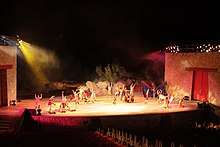
The outdoor musical extravaganza Viva! El Paso is performed in the McKelligon Canyon Amphitheatre. It is locally produced and chronicles the 400-year history and cultural evolution of the El Paso region. The show is performed each Friday and Saturday night in June, July, and August. Viva! El Paso has entertained local residents and out-of-town visitors for over 35 years.[113]
El Paso Symphony Orchestra
The El Paso Symphony was established in the 1930s, it is the oldest performing arts organization in El Paso and the longest continuously running symphony orchestra in the state of Texas.[114] It has received both national and international recognition as a result of its very successful tours of Germany in 1996 and Turkey in 2000, and continues to represent the El Paso region with pride and distinction. The El Paso Symphony Orchestra Association season is anchored by 12 classical concerts. Special events serve as outreach toward new audiences.
Ballet in El Paso
Ballet was largely nonexistent in El Paso until the arrival of Ingeborg Heuser, a professional ballerina from Germany, in the 1950s. Heuser taught ballet at the University of Texas at El Paso for 47 years and founded the city's first professional ballet company, firstly known as Texas Western Civic Ballet and eventually as Ballet El Paso. The company dissipated due to financial trouble in 1997 and Heuser retired from UTEP soon after.[115][116]
The El Paso Youth Ballet was founded in 2009 by Heuser's previous student, Marta Katz, following Heuser's departure from the university. With students from the youth ballet, Heuser staged her last Nutcracker in 2006. The youth company continues to perform the Nutcracker and other pre-professional pieces in and around the El Paso area. The company provides the only platform for young ballet dancers to train and perform at such a level within the city since the folding of Ballet El Paso.[117]
El Paso City Ballet is a current professional ballet company in El Paso, providing local employment for professional dancers in the field of ballet. The company performs a variety of classical and contemporary works choreographed by Artistic Director Lisa Skaf and artists from the US and Latin America.[118] It has been active since 2005, performing yearly productions.
Theaters
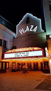
The Plaza Theatre is a National Historic Building of Significance built in 1930.[119] It features the 2,050-seat Kendall Kidd Performance Hall, and the smaller 200-seat Philanthropy Theatre. It hosts Broadway productions, musical concerts, individual performers and the annual Plaza Classic Film Festival.[119]
The Abraham Chavez Theatre is a 2,500-seat concert hall adjacent to the Williams Convention Center. Its exterior resembles a sombrero and features a three-story glass main entrance. The Abraham Chavez Theatre is named after Maestro Abraham Chavez who was the longtime conductor of the El Paso Symphony. Inside, the theatre has a 5,000-square-foot (460 m2) lobby and a 40-by-56-foot stage as well as 14 dressing rooms. The theater's seating is in three levels. There is also a meeting room adjacent to the theater.[119]
Events held at Chavez Theatre include concerts, Broadway shows, graduation ceremonies, performances of the El Paso Symphony Orchestra, and other special events.
McKelligon Canyon is a 90-acre (360,000 m2) park, located in the Franklin Mountains, open to hikers and picnickers. In the canyon, McKelligon Canyon Amphitheatre is surrounded on three sides by canyon walls; the 1,500-seat amphitheater is used for concerts and special events, such as Viva! El Paso.[120]
The El Paso Playhouse is a community theatre that provides entertainment and educational experiences to a diverse multicultural population through the high quality production of plays and theatrical events. The Playhouse provides a venue for artists, technicians, patrons and community members to participate in the arts through regularly scheduled season productions, and holiday performances. The theater is affiliated with Kids-N-Co, a theater for child actors to children's performances .[121]
The UTEP Dinner Theatre is located inside the campus of the University of Texas at El Paso and was founded in 1983 and is entirely produced, designed and directed by students. The theatre presents 4 fully staged musicals each season and a fully staged student produced musical.[122]
Area museums
The Centennial Museum and Chihuahuan Desert Gardens, located on the grounds of UTEP, includes a comprehensive collection of El Paso Brown, Native American pottery, as well as educational exhibits for students.
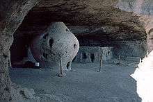
The El Paso Museum of Archaeology is located on the eastern slope of North Franklin Mountain, west of Gateway South Blvd. on TransMountain Rd.[123] Its grounds include native plants of the American Southwest, as well samples of Native American shelters, in an unspoiled location. The museum includes dioramas for school children which illustrate the culture and geology of the American Southwest, such as Hueco Tanks in El Paso County. One diorama (see image to the right) is of the Cueva de la Olla[124] (cave of the pot) which is located in the Sierra Madre of Chihuahua, an example of the Paquimé culture.[125]
The El Paso Museum of Art is located next to the Plaza Theater adjacent to San Jacinto Plaza, the public square downtown. It contains works of southwestern artists such as Tom Lea.
Other area museums include:
- El Paso Holocaust Museum and Study Center
- International Museum of Art El Paso
- El Paso Museum of History[126]
- Fort Bliss Museums and Study Center[127]
- Insights El Paso Science Museum[128]
- The Magoffin Homestead, dating from 1875, is now a state historic site.
- The National Border Patrol Museum is located adjacent to the El Paso Museum of Archaeology.
- Railroad and Transportation Museum of El Paso[129]
- The Gene Roddenberry Planetarium[130]
- Lynx Exhibits[131]
Sites within the city limits
- Ysleta Mission is recognized as the oldest continuously operated parish in the State of Texas.
- Cathedral of Saint Patrick erected in 1916 is the seat of the Roman Catholic Diocese of El Paso.
- Chamizal National Memorial
- El Paso Zoo – a 35-acre (14 ha) facility housing 220 species.[132]
- Magoffin Home State Historic Site
- Plaza Hotel
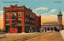
- Union Depot
- El Paso High School
- University of Texas at El Paso The university's distinctive style is a type of fortress architecture, Dzong, found in the present and former Buddhist mountain kingdoms of the Himalayas, Bhutan and Tibet.[133][134]
Sports
El Paso is home to the Sun Bowl, the second oldest consecutive college football contest[135] (after the Rose Bowl). Its first game was held in 1935.[135]
On September 18, 2012, the city council voted to approve the demolition of its city hall to make way for Southwest University Park,[136] the new home of the El Paso Chihuahuas Triple-A team (San Diego Padres affiliate); it opened in 2014. The team was purchased by Mountainstar Sports Group of El Paso.[137] City Hall was demolished on April 14, 2013.
The El Paso Marathon takes place annually since 2007. The El Paso Patriots played their last season in 2013 and are no longer an organization.
El Paso will get a USL team starting in 2019. They will play at the Southwest University Park.[138]
| Club | Sport | League | Venue | Capacity |
|---|---|---|---|---|
| El Paso Chihuahuas | Baseball | AAA PCL | Southwest University Park | 9,500 |
| El Paso Locomotive FC | Soccer | USLC | Southwest University Park | 9,500 |
| El Paso Rhinos | Ice Hockey | WSHL | Sierra Providence Event Center | 5,250 |
| El Paso Coyotes | Indoor Soccer | MASL | El Paso County Coliseum | 6,500 |
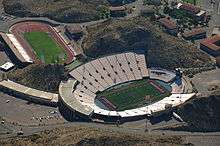
| UTEP Miners Football | NCAA Division I FBS Football | C-USA | Sun Bowl Stadium | 51,500 |
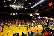
| UTEP Basketball Men | NCAA Division I Basketball | C-USA | Don Haskins Center | 12,000 |
| UTEP Basketball Women | NCAA Division I Basketball | C-USA | Don Haskins Center | 12,000 |
| UTEP Softball | NCAA Division I Softball | C-USA | Helen of Troy Field | 607 |
| UTEP Track and Field | NCAA Division I Track and Field | C-USA | Kidd Field | 15,000 |
| UTEP Women's Soccer | NCAA Division I Soccer | C-USA | University Field | 500 |
| EPCC Baseball | NJCAA Division I Baseball | WJCAC | EPCC Baseball Field | 520 |
Parks and recreation
El Paso is home to the largest urban park in the nation.[139] The Franklin Mountains State Park, with its more than 24,248 acres (9,813 ha), is completely located within the city limits. It is considered a small range (23 miles long, 3 miles (4.8 km) wide) that extends from city north into New Mexico.[140] It is home to the highest peak in the county North Franklin Mountain at 7,192 feet.The park is open year-round for recreation including hiking, mountain biking, picnicking, scenic driving and views of the city.
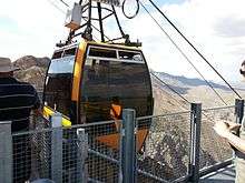
The Wyler Aerial Tramway is operated by the Texas Parks and Wildlife Department and is in the Franklin Mountains State Park. The tramway complex covers 196 acres (0.79 km2) on the east side of the Franklin Mountains. The gondolas travel along two 2,600-foot (790 m) 1 3⁄8 diameter steel cables to Ranger Peak, 5,632 feet (1,717 m) above sea level. The trip takes about four minutes and lifts riders 940 feet (290 m) above the boarding area.The tramway was built in 1959 by KTSM radio to aid in the construction of a transmitter tower. Karl O. Wyler managed the project. First opening to the public as the El Paso Aerial Tramway, the facility provided rides from 1960 to 1986, when high liability insurance costs forced the tram to stop public operations. The tram was only used to service the transmitter towers. Wyler donated the tramway for public use in his will. The Texas Parks and Wildlife Department accepted the donation in 1997 and renovated and re-opened the tramway to the public in 2001.
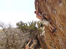
Hueco Tanks State Historic Site is a Texas historic site in the Hueco Tanks area, approximately 32 miles (51 km) northeast of downtown El Paso and just west of the Hueco Mountains. The park is popular for recreation such as birdwatching and bouldering, and is culturally and spiritually significant to many Native Americans. This significance is partially manifested in the pictographs (rock paintings) that can be found throughout the region, many of which are thousands of years old.[141] Hueco Tanks is also widely regarded as one of the best areas in the world for bouldering (rock climbing, low enough to attempt without ropes for protection), unique for its rock type, the concentration and quality of the climbing, and after which the Hueco bouldering grades are named. In any given climbing season, which generally lasts from October through March, it is common for climbers from across Europe, Asia, and Australia to visit the park. Since implementation of the Public Use Plan, following a brief closure of the entire park due to the park service's inability to manage the growing crowds of international climbers, volunteer or commercial guides are required to access more than 2/3 of the park's area. Only North Mountain is accessible without guides, and then only for about 70 people at any given time. The park offers camping and showers for a small fee a day or, as is most popular for climbers, the nearby Hueco Rock Ranch offers camping where climbers can relax and socialize.
The Chamizal National Memorial is a 54.90-acre (22.22 ha) memorial park that serves primarily as a cultural center and contains art galleries, a theater, and an amphitheatre. A museum detailing the history of the Mexico–U.S. border is located inside the visitor center.
The city is also home to 242 municipal parks.[142][143]
Botanical gardens
- The Chihuahuan Desert Gardens (CDG) display the flora of the Chihuahuan Desert and adjacent regions in the United States and Mexico. The Gardens were formally dedicated in September 1999 and contain over 625 different species of plants, comprising one of the largest captive assemblages of Chihuahuan Desert flora in the world.[144]
- The El Paso Municipal Rose Garden (officially named the All-American Rose Selection (AARS) public garden) is one of over 100 certified gardens within the United States. There are over 1,900 rosebushes with 500 varieties. The wrought-iron fenced garden has wide walkways with handicap accessibility, raised beds, a waterfall, and trees and shrubs. Several new rose varieties are planted each year, and after two years the highest-rated are named and receive the AARS symbol.[145]
- Feather Lake is a 43.5-acre (17.6 ha) wildlife sanctuary based on a 40-acre (16 ha) wetland built by the City of El Paso in 1969 as a stormwater-retention basin. Since 1976, the El Paso/Trans-Pecos Audubon Society has leased this land from the city and managed it for wildlife. Over 200 different species of birds, especially those associated with water, have been observed at the sanctuary. Fauna residing there include muskrats, spiny softshell turtles, pond sliders, and Trans-Pecos striped whiptail lizards.[146]
- Keystone Heritage Park comprises an Archaic-period archaeological site, wetlands, and a desert botanical garden. The 4,500-year-old site is one of the oldest villages in the United States. The wetlands are home to many birds, and over 200 species have been spotted there on their seasonal migrations. The botanical garden features a variety of native plants, and includes a pavilion and a replica of an Archaic period brush hut. The newest component, The Chihuahuan Desert Experience, is a work in progress that will allow visitors to stroll the 900-mile (1,400 km) length of desert over a 17-acre (6.9 ha) recreation of the plant indigenous life.[147]
- Rio Bosque Wetlands is a 372-acre (151 ha) city park, managed by the Center for Environmental Resource Management of the University of Texas at El Paso, which began restoration efforts in 1998. In the fall and winter, water flows through the park along the route of the river before it was confined within levees in the 1930s. Many animals and birds have returned to the area as the restoration proceeds, and over 200 species of birds have been sighted.[148]
Golf courses
The metro area has 16 golf courses including Butterfield Trail Golf Club, the only public premium daily fee Tom Fazio designed golf course in the state of Texas.[149] It was ranked No. 1 in Texas and No. 3 in the Nation on Golfweek's 2013 Best Municipal Golf Courses.[150] Other golf courses found in the county include:
Next door in Dona Ana County there are the following golf courses:
Government
| El Paso City Council[165]
• City Council is officially nonpartisan | ||
|---|---|---|
| Peter Svarzbein | District 1, Westside | |
| Alexsandra Annello | District 2, West Central | |
| Cassandra Hernandez | District 3, East Central | |
| Dr. Sam Morgan | District 4, Northeast | |
| Isabel Salcido | District 5, Eastside | |
| Claudia Ordaz | District 6, East Valley | |
| Henry Rivera | District 7, Mid Valley | |
| Cissy Lizarraga | District 8, Southside & Upper Valley | |
City
The city government is officially nonpartisan. Mayors and city council members are elected for four year terms and may not be elected more than twice or serve for more than 10 years in their respective offices.[166] Municipal elections are currently held in May in odd-numbered years, but a voter-approved charter amendment will change this to November in even-numbered years, beginning in 2018.[167] Council members elected in 2015 will serve through December 2018, and council members and the mayor elected in 2017 will serve through December 2020. Those elected in 2018 and 2020 will serve regular four-year terms.[168]
The city operates under a council–manager form of government. Power is concentrated in the eight-member elected city council and mayor, who hire a manager to carry out its directives and oversee the delivery of public services. The current city manager is Tommy Gonzalez[169] and the current mayor of El Paso is Dee Margo, who was elected to the office in 2017.[170]
The terms of Mayor Margo and Councillors Annello, Hernandez, Morgan, and Rivera will end in 2020. The terms of Lizarraga, Ordaz, Salcido, and Svarzbein will end in 2022.
Ordaz has been on the council since 2014, Svarzbein since 2015, Annello, Hernandez, Lizarraga, Morgan, and Rivera since 2017, and Salcido since 2018. Due to the term limits clause of the city charter Ordaz and Svarzbein are ineligible for reelection. All other councilors and the mayor are eligible for reelection.
County
The El Paso County Judge is Ricardo Samaniego, and the county commissioners are Carlos Leon (Precinct 1), David Stout (Precinct 2), Vince Perez (Precinct 3), and Carl Robinson (Precinct 4). The commissioners and the county judge are Democrats.
Leon and Perez were first elected to their positions in 2012, were re-elected in 2016, and have been in office since 2013. Stout was first elected to his position in 2014, and has been in office since 2015. Samaniego and Robinson were first elected in 2018, and have been in office since 2019.
State
The El Paso metropolitan area is represented in the Texas State House by Democrats Cesar Blanco, Art Fierro, Mary Gonzalez, Joe Moody, and Lina Ortega, and in the State Senate by José R. Rodríguez (D-El Paso).[171]
The Texas Department of Criminal Justice operates the El Paso I District Parole Office in the city. The El Paso II District Parole Office is in an unincorporated area east of Horizon City.[172]
Federal
El Paso City and County vote overwhelmingly Democratic, like most of the Texas–Mexico border area and urban Texas.[173]
In the United States House of Representatives, most of El Paso is part of Texas's 16th congressional district represented by Democrat Veronica Escobar. A small sliver in the eastern part of the city is part of Texas's 23rd congressional district, represented by Republican Will Hurd.[174] The current U.S. Senators for Texas are Ted Cruz (R-Texas) and John Cornyn (R-Texas).
Education
El Paso is home to the University of Texas at El Paso, the largest public university in the region. UTEP was ranked as the 7th best university in Washington Monthly's 2013 National University Rankings, just behind Stanford and ahead of Harvard.[175] Also, the university's School of Engineering is the nation's top producer of Hispanic engineers with M.S. and Ph.D. degrees.[176]
El Paso is also home to Texas Tech University Health Sciences Center at El Paso, Paul L. Foster School of Medicine, Texas Tech College of Architecture at El Paso, Brightwood College, Park University, Southwest University, Webster University and the University of Phoenix. Also due to its proximity, many El Paso students attend New Mexico State University where the school offers in-state tuition to El Paso County residents.[177]
The El Paso Community College serves most of the area as well as several technical schools and for profit schools. El Pasoans also have access to the Doña Ana Community College with campuses in Sunland Park, Anthony and Chaparral, New Mexico: This community college is a part of the New Mexico State University system.
El Paso area students primarily attend public schools in four school districts, El Paso Independent School District, Ysleta Independent School District, Socorro Independent School District and Canutillo Independent School District. Numerous accredited private preparatory schools also serve El Paso students. These include various pre-high school religious (Christian, Catholic, Jewish) affiliates and Montessori schools, Cathedral High School, Loretto Academy, Father Yermo High School, Lydia Patterson Institute, Faith Christian Academy, El Paso Jewish Academy, Rose of Sharon Christian Academy, Zion Lutheran Day School and Radford School. The University of El Paso offers the country's only bilingual M.F.A. creative writing program [178].
El Paso is home to bi-national economic development groups; the Hub of Human Innovation and Technology Hub. The industry groups' tertiary vocational programs, give workforce training in automation, robotics and AI technology [179][180].
Public libraries
The El Paso Public Library serves the needs of the public in El Paso, TX. It consists of 12 branches, a bookmobile, a mobile computer classroom and a mobile outreach unit (Kidsmobile). It also has multiple outreach services available.[181]
Media
Newspapers
The main newspapers are the English-language daily El Paso Times, founded in 1881; the Spanish-language daily El Diario de El Paso, and the online newspaper El Paso Herald Post started in 2015. The original and defunct El Paso Herald Post was also founded in 1881 as the El Paso Herald, which then merged with the El Paso Post in 1931. The paper was shut down in 1997. El Paso also has some weekly and niche magazines:
Radio stations
Radio stations from Las Cruces, New Mexico, and Ciudad Juárez, Chihuahua, can also be heard within the El Paso market.
Television
El Paso was the largest city in the United States without a PBS television station within the city limits until 1978. El Paso viewers had to watch channel 22, KRWG, from Las Cruces until 1978. In fact, the city had only three English-speaking channels and two Spanish-language channels (channel 2 and channel 5) from Juarez, and cable TV subscribers in the 1970s and 1980s could receive four Los Angeles independent channels: KTLA, KHJ, KTTV and KCOP as well as Spanish-language stations KMEX of Los Angeles and KWEX of San Antonio usually sharing the same cable channel slot. Over time, as more television stations signed on, more cable channels were added and those stations added network affiliations, the Los Angeles and San Antonio stations disappeared from the lineup. The last to be removed was KTLA in the fall of 2006 as a consequence of the WB-UPN merger into The CW, when KVIA-TV launched a digital subchannel with the network's programming.
El Paso's current television stations are as shown in the list below:
- KDBC 4.1 (CBS)
- KDBC-TV 4.2 (TBD)
- MeTV 4.3 (MeTV)
- KDBC-TV 4.4 (Dabl)
- KVIA 7.1 (ABC)
- KVIA-TV 7.2 (CW)
- KVIA-TV 7.3 (Ion)
- KVIA-TV 7.4 (Azteca)
- KTSM-TV 9.1 (NBC)
- KTSM-TV 9.2 (Estrella)
- KTSM-TV 9.3 (Escape)
- KTSM-TV 9.4 (Laff)
- KCOS 13.1 (PBS)
- KCOS13 13.2 (EPCC TV)
- KCOS13 13.3 (Create)
- KCOS13 13.4 (CITY-15)
- KFOX-TV 14.1 (FOX)
- KFOX-TV 14.2 (Comet)
- KFOX-TV 14.3 (Charge)
- KFOX-TV 14.4 (Stadium)
- KINT-TV 26.1 (Univision)
- KINT-TV 26.2 (Grit)
- KINT-TV 26.3 (LATV)
- KINT-TV 26.4 (Bounce)
- KTDO 48.1 (Telemundo)
- KTFN 65.1 (UniMás)
- KTFN 65.2 (Justice Network)
- KTFN 65.3 (Quest)
Cellular phone coverage
KTSM-TV reports that cellular phone users in El Paso may be subject to international calling fees.[188]
In popular culture
Infrastructure
Healthcare
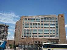
El Paso is the medical hub of West Texas and Southern New Mexico, hosting numerous state-of-the-art medical centers. Some of the city's top hospitals include University Medical Center, William Beaumont Army Medical Center, Sierra Medical Center, Las Palmas Medical Center, Del Sol Medical Center, Sierra Providence East Medical Center, El Paso Children's Hospital,[189] and Providence Memorial Hospital. University Medical Center is the only level I trauma center in the region. William Beaumont Army Medical Center will be replaced by a new state of the art $1.2 billion Fort Bliss Replacement Hospital[190] expected to open in 2020.[191] El Paso's newest hospital, The Hospitals of Providence Transmountain Campus opened in Northwest El Paso on January 27, 2017. The 106-bed teaching hospital is a collaboration between Texas Tech University Health Sciences Center El Paso and The Hospitals of Providence.
El Paso is also home to the Medical Center of the Americas, an integrated complex of medical facilities anchored by Texas Tech University Health Sciences Center at El Paso, Paul L. Foster School of Medicine, University Medical Center, the El Paso Psychiatric Center and by the El Paso Children's Hospital. It is also the site to the Cardwell Collaborative biomedical research building, the Gayle Greve Hunt School of Nursing, and the Graduate School of Biomedical Sciences. The Woody L. Hunt School of Dental Medicine is expected to open in 2021 in the MCA area as well.
Transportation
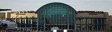
El Paso is served by El Paso International Airport and Amtrak via the historic Union Depot.
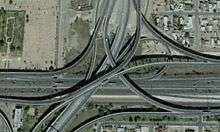
Several roads and highways connect El Paso, including Interstate 10, US Highway 54 (known locally as "54", the "North-South Freeway" or officially as the Patriot Freeway), Spur 601 (Liberty Expressway), US Highway 180 and US Highway 62 (Montana Avenue), US Highway 85 (Paisano Drive), Loop 375, Loop 478 (Copia Street-Pershing Drive-Dyer Street), numerous Texas Farm-to-Market roads (a class of state highway commonly abbreviated to FM) and the city's original thoroughfare, State Highway 20, the eastern portion of which is known locally as Alameda Avenue (formerly US Highway 80). Texas 20 also includes portions of Texas Avenue in central El Paso, Mesa Street from Downtown to the West Side, and Doniphan Drive on the West Side. Northeast El Paso is connected to West El Paso by Transmountain Road (Loop 375). The city also shares four international bridges and one railbridge with Ciudad Juárez, Mexico. In 2009, El Paso was home to number 52, number 98, and number 100 of the 100 most congested roads in Texas, which are, respectively: North Zaragoza Road between Sun Fire Boulevard and Interstate 10; Lee Trevino Drive between Montana Avenue and Interstate 10; and Interstate 10 between Patriot Freeway and Loop 375.[192]
In 2009, 79.8% of El Paso (city) commuters drive to work alone. The 2009 mode share for El Paso (city) commuters are 10.3% for carpooling, 2.4% for transit, 2.5% for walking, and .2% for cycling.[193] In 2016, Walk Score ranked El Paso as the 32nd most walkable of the 50 largest U.S. cities, rating it "car-dependent".[194] The city of El Paso has a slightly lower than average percentage of households without a car. In 2015, 7.4 percent of El Paso households lacked a car, and increased to 8.4 percent in 2016. The national average was 8.7 percent in 2016. El Paso averaged 1.82 cars per household in 2016, compared to a national average of 1.8.[195]
Airports
- El Paso International Airport, a public airport four miles (6 km) northeast of downtown El Paso. It is the largest commercial airport in West Texas, handling 3,260,556 passengers in 2018.[196] The El Paso International Airport serves the El Paso-Las Cruces Combined Statistical area.
- Biggs Army Airfield
- Horizon Airport
- Dona Ana Airport[197]
- Las Cruces International Airport
Passenger rail
- Amtrak, the national passenger rail system, serves El Paso at the Union Depot, operating its Sunset Limited/Texas Eagle three times weekly between Los Angeles and New Orleans via San Antonio and Houston and between Los Angeles and Chicago via San Antonio and Fort Worth.
Major highways
.svg.png)


- Border West Expressway under construction (as of 2018), parallel to I-10 through downtown and the west side.
Mass transit
The Sun Metro Mass Transit System operates a system of medium- to large-capacity natural gas-powered buses all around the city of El Paso.[200]
El Paso County Transit makes trips with small-capacity buses mainly in the eastern El Paso area.
In 2011, Sun Metro was named the most outstanding public transit system of the year in all of North America for a mid-size transit system by the American Public Transportation Association.
On September 1, 2009, NMDOT Park and Ride began operating commuter bus service to and from Las Cruces, New Mexico.[201]
Historically, El Paso and Ciudad Juarez had a shared streetcar system with a peak electrified route mileage of 64 miles (103 km) in 1920. The first electrified line across the Rio Grande, which opened on January 11, 1902, was preceded by a network that relied on animal labor. The system quickly spread into residential and industrial areas of El Paso. In 1913, a 12-mile (19 km) interurban line was built to Ysleta. At the close of 1943, the holding company El Paso Electric sold its subsidiary, the El Paso Electric Railway Company and its Mexican counterpart, to one of National City Lines' subsidiaries. This resulted in the formation of El Paso City Lines, whose domestic streetcar lines were replaced by buses in 1947.[202] The international streetcar line which crossed the border via the Stanton Street Bridge continued to operate until 1973. In 1977, El Paso City Lines and two other bus companies were bought by the municipality and merged to form Sun City Area Transit (SCAT). In 1987, SCAT restyled itself Sun Metro.[203]
El Paso Streetcar
The El Paso Streetcar is a streetcar system that opened for service on November 9, 2018, and uses a fleet of restored PCC streetcars[204] that had served the city's previous system until its closure in 1974.[205] The system covers 4.8 miles (7.7 km)[206][207] (round trip) in two loops from Downtown El Paso to University of Texas at El Paso. The system was constructed under the authority of the Camino Real Regional Mobility Authority, but when the major construction was completed, around spring 2018, it was transferred to Sun Metro, for operation and maintenance.[205] As of 2016, construction of the system was projected to cost $97 million.[206]
International border crossings
%2C_June_2016.jpg)
The first bridge to cross the Rio Grande at El Paso del Norte was built in the time of Nueva España, over 250 years ago, from wood hauled in from Santa Fe.[208] Today, this bridge is honored by the modern Santa Fe Street Bridge, and Santa Fe Street in downtown El Paso.
Several bridges serve the El Paso–Ciudad Juárez area:
- Bridge of the Americas, also known as the Cordova Bridge.
- Good Neighbor International Bridge, also known as the Stanton Street Bridge
- Paso del Norte International Bridge, also known as the Santa Fe Street Bridge.
- Ysleta–Zaragoza International Bridge, also known as the Zaragoza Bridge.
The city collects tolls at its international bridges.[209]
Notable people
See also
- List of museums in West Texas
- National Register of Historic Places listings in El Paso County, Texas
Notes
Footnotes
- Official records for El Paso kept January 1879 to June 1947 at downtown and at El Paso Int'l since July 1947. For more information, see Threadex
Source notes
- "Visit El Paso, Texas". El Paso Convention & Visitors Bureau. Retrieved November 6, 2013.
- "El Chuco tells of El Paso pachuco history – Ramon Renteria". El Paso Times. June 30, 2013. Archived from the original on February 1, 2014. Retrieved January 5, 2014.
- "U.S. Census website". United States Census Bureau. Retrieved June 19, 2015.
- "QuickFacts". United States Census Bureau.
- "US Board on Geographic Names". United States Geological Survey. October 25, 2007. Retrieved January 31, 2008.
- "QuickFacts". Retrieved May 24, 2019.
- "Juarez Outlook 2017, Desarrollo Economico" (PDF). desarrolloeconomico.org. 2017. Retrieved February 20, 2019.
- "Annual Estimates of the Resident Population: April 1, 2010 to July 1, 2017". factfinder.census.gov. Archived from the original on February 14, 2020. Retrieved February 20, 2019.
- "2 Cities and 4 Bridges Where Commerce Flows". The New York Times. March 28, 2007. Retrieved July 27, 2013.
- "El Paso refinery to change ownership again as Andeavor to be sold to Marathon for $23.3B". elpasotimes.com. May 1, 2018. Retrieved March 1, 2019.
- "Medical Center of the Americas Foundation". Retrieved April 27, 2016.
- "El Paso businessman to make large donation for medical center". El Paso Times. July 13, 2013. Archived from the original on January 3, 2015. Retrieved January 3, 2015.
- "Sun Bowl Association Unveils 80th Anniversary Logo". Sun Bowl Association. 2013. Retrieved February 8, 2014.
- "Fort Bliss Fact Sheet". Archived from the original on November 28, 2016.
- "El Paso Named Safest U.S. City". Texas Monthly. 2013. Retrieved February 6, 2014.
- "City Crime Rankings 2014". CQ Press. 2014. Archived from the original on January 8, 2014. Retrieved January 7, 2014.
- "Hueco Tanks State Historic Site Videos Big Bend Country Region". Archived from the original on November 22, 2007.
- Leon C. Metz (1993). El Paso Chronicles: A Record of Historical Events in El Paso, Texas. El Paso: Mangan Press. ISBN 0-930208-32-3.
- Mark Sumner (January 30, 2011). "America, the artifact".
- El Paso, A Borderlands History, by W.H. Timmons, pp. 74, 75
- El Paso, Texas from the Handbook of Texas Online
- Richard H. Orton, ed. (1890). Records of California Men in the War of the Rebellion 1861 to 1867. Sacramento: Adjutant General's Office. p. 672. Retrieved July 1, 2010.
- "elpasonext – Downtown El Paso History". Elpasotexas.gov. Archived from the original on July 5, 2009. Retrieved July 1, 2010.
- Harris 2009, p. 1.
- Harris 2009, p. 15.
- Hampton 1910.
- Daily Mail 1909, p. 7.
- Harris 2009, p. 16.
- Hammond 1935, pp. 565–66.
- Harris 2009, p. 213.
- Harris 2004, p. 26.
- "Plan of San Diego". Texas State Historical Association. June 15, 2010. Retrieved October 4, 2015.
- Víctor M. Macías-González (1995). Mexicans "of the better class": The elite culture and ideology of Porfirian Chihuahua and its influence on the Mexican American generation, 1876–1936. El Paso: UTEP.
- Emmons K. Ellsworth, ed. (January 15, 1916). Special Census of the Population of El Paso, Tex: January 15, 1916. United States Bureau of the Census. Retrieved July 1, 2010.
- "Chicanos Strike At Farah" (PDF). www.marxists.org. Retrieved December 7, 2018.
- "The Best of the Texas Century—Business". Texas Monthly. January 20, 2013. Retrieved December 7, 2018.
- "Texas Walmart shooting: Twenty killed in El Paso gun attack". BBC. August 4, 2019. Retrieved August 3, 2019.
- Blankstein, Andrew; Burke, Minyvonne (August 3, 2019). "El Paso shooting: 20 people dead, 26 injured, suspect in custody, police say". NBC News. Retrieved August 3, 2019.
- "Time changes in Chihuahua". Timeanddate.com. Retrieved July 1, 2010.
- "Distance from El Paso, TX to Phoenix, AZ". check-distance.com. Retrieved December 2, 2018.
- "Distance from El Paso, TX to Santa Fe, NM". check-distance.com. Retrieved December 2, 2018.
- "Distance from El Paso, TX, USA to Chihuahua, Mexico". Retrieved December 2, 2018.
- "Distance from El Paso, TX, USA to Hermosillo, Sonora, Mexico". Retrieved December 2, 2018.
- "Distance from El Paso, TX to Austin, TX". check-distance.com. Retrieved December 2, 2018.
- "Distance from El Paso, TX to Los Angeles, CA". check-distance.com. Retrieved December 2, 2018.
- "Distance from El Paso, TX to Orange, TX". check-distance.com. Retrieved December 2, 2018.
- "Geographic Identifiers: 2010 Demographic Profile Data (G001): El Paso city, Texas". U.S. Census Bureau, American Factfinder. Archived from the original on February 12, 2020. Retrieved January 10, 2013.
- Carlos A. Rincón (2002). "Solving Transboundary Air Quality Problems in the Paso Del Norte Region". In Linda Fernandez; Richard Carson (eds.). Both Sides of the Border. Springer. ISBN 1-4020-7126-4.
- "NowData – NOAA Online Weather Data". National Oceanic and Atmospheric Administration. Retrieved February 7, 2012.
- "El Paso Heavy Snow Events". Retrieved September 14, 2014.
- "Climatography of the United States No. 20: El Paso Intl AP, TX 1971–2000" (PDF). National Oceanic and Atmospheric Administration. Archived from the original (PDF) on September 7, 2013. Retrieved April 27, 2010.
- "National Centers for Environmental Information (NCEI) formerly known as National Climatic Data Center (NCDC) – NCEI offers access to the most significant archives of oceanic, atmospheric, geophysical and coastal data" (PDF). noaa.gov. Archived from the original (PDF) on February 12, 2015. Retrieved July 16, 2015.
- "Rolling Blackouts Resume Friday Morning". February 4, 2011.
- J. Rogash; M. Hardiman; D. Novlan; T. Brice; V. MacBlain. "Meteorological Aspects of the 2006 El Paso Texas Metropolitan Area Floods". NOAA/National Weather Service, Weather Forecast Office, Santa Teresa, New Mexico/El Paso, Texas.
- "Storm 2006 Hits El Paso". www.elpasotexas.gov. 2006. Archived from the original on May 20, 2008. Retrieved February 16, 2014.
- "Station Name: TX EL PASO INTL AP". National Oceanic and Atmospheric Administration. Retrieved March 21, 2014.
- "WMO Climate Normals for EL PASO/INT'L ARPT TX 1961–1990". National Oceanic and Atmospheric Administration. Retrieved March 10, 2014.
- "Population of Central, El Paso, Texas". Retrieved February 24, 2019.
- Metz, Leon. "Downtown El Paso has colorful history Archived July 31, 2012, at Archive.today." El Paso Times. November 30, 2006. Retrieved on March 6, 2010.
- "11 Most Endangered: Chihuahuita and El Segundo Barrio". National Trust for Historic Preservation. Archived from the original on April 19, 2017. Retrieved April 18, 2017.
- Magruder, Alicia; Dickey, Gretchen (2004). "Kern Place Neighborhood: The Man Behind a Name". Borderlands. 23.
- Gray, Robert (July 5, 2016). "Cincinnati Street claws back losses". El Paso Inc. Retrieved May 2, 2017.
- Gray, Robert (September 14, 2015). "Vacancies trouble Cincinnati district". El Paso Inc. Retrieved May 2, 2017.
- Worthington, Patricia. El Paso and the Mexican Revolution. Arcadia Publishing, 2010, p. 20.
- Corchado, Alfredo. "Families, businesses flee Juárez for U.S. pastures." The Dallas Morning News. Sunday March 7, 2010. Retrieved on March 10, 2010.
- "Census Explorer". census.gov. Retrieved February 25, 2019.
- "The ZIP Code Turns 50 Today; Here Are 9 That Stand Out". NPR. 2013. Retrieved February 13, 2014.
- "Metropolitan Statistical Areas and Components". U.S Census Bureau. November 2004. Retrieved June 27, 2013.
- writer, Aaron Montes / El Paso Inc staff. "It's now 18 stories: Downtown tower plan gets big upgrade". El Paso Inc.
- "El Paso - Statistics - EMPORIS". www.emporis.com.
- "El Paso County Historical Commission". Archived from the original on May 29, 2018. Retrieved May 29, 2018.
- "Overview". Archived from the original on September 17, 2018. Retrieved May 29, 2018.
- "U.S. Decennial Census". U.S. Census Bureau. Retrieved January 14, 2012.
- "Texas Almanac: City Population History 1850–2000" (PDF). Retrieved September 22, 2012.
- "Population Estimates". United States Census Bureau. Retrieved June 8, 2018.
- "El Paso–Juarez Regional Historic Population Summary – Development Services Department, Planning Division" (PDF). PDF. Archived from the original (PDF) on December 19, 2011. Retrieved September 22, 2012.
- "Texas State Historical Association". June 12, 2010. Retrieved September 22, 2012.
- "United States Census Quick Facts". census.gov. Retrieved February 25, 2019.
- "El Paso (city), Texas". State & County QuickFacts. U.S. Census Bureau. Archived from the original on May 8, 2013.
- "Profile of General Demographic Characteristics: 2000" (PDF). United States Census Bureau. Archived from the original (PDF) on September 4, 2015.
- "Race and Hispanic Origin for Selected Cities and Other Places: Earliest Census to 1990". U.S. Census Bureau. Archived from the original on August 12, 2012.
- From 15% sample
- "State & County QuickFacts – U.S Census Bureau". U.S. Census Bureau. Archived from the original on May 8, 2013. Retrieved May 23, 2013.
- "State & County QuickFacts – U.S Census Bureau". U.S. Census Bureau. Archived from the original on May 8, 2013. Retrieved May 23, 2013.
- "City of EL Paso Financial Services". elpasotexas.gov. Archived from the original on June 10, 2016. Retrieved May 23, 2016.
- "T&T Staff Management". Retrieved May 23, 2016.
- "Bureau of Economic Analysis Gross Domestic Income by Metropolitan Area 2017" (PDF). Bureau of Economic Analysis. September 18, 2018. Retrieved February 20, 2019.
- "Mayor John Cook The Exit Interview". El Paso Inc. June 9, 2013. Retrieved August 20, 2013.
- "Top Ports of Border Crossings". RITA. 2013. Retrieved February 16, 2014.
- "Fortune 500 Headquarters in Texas – Office of the Governor Economic Development and Tourism" (PDF). Fortune 500. May 2013. Archived from the original (PDF) on June 15, 2013. Retrieved July 27, 2013.
- "FORTUNE 500 Headquarters in Texas – Office of the Governor Economic Development and Tourism" (PDF). Fortune Magazine. May 2013. Archived from the original (PDF) on June 15, 2013. Retrieved June 29, 2013.
- "El Paso: Economy – Major Industries and Commercial Activity". www.City-Data.com. Retrieved February 16, 2014.
- "Charles Schwab to bring 445 jobs to El Paso". El Paso Times. July 24, 2014. Archived from the original on February 9, 2015. Retrieved February 6, 2015.
- "El Paso's 28 companies second in nation for Hispanic Business 500". El Paso Times. July 30, 2013. Archived from the original on August 25, 2013. Retrieved August 1, 2013.
- "Fort Bliss, Beaumont infuse $6 billion into El Paso economy". El Paso Times. March 8, 2013. Archived from the original on August 25, 2013. Retrieved January 3, 2015.
- "U.S. Air Force chooses Ft. Bliss for training center". KVIA. June 27, 2013. Archived from the original on August 25, 2013. Retrieved July 27, 2013.
- "ADP plans to add 1,100 jobs in El Paso by 2020". El Paso Times. September 12, 2014. Archived from the original on September 12, 2014. Retrieved September 12, 2014.
- "Convention and Tourism Highlights – City of El Paso FY2013 Manager's Proposed Budget" (PDF). El Paso Convention & Visitor's Bureau. Archived from the original (PDF) on February 22, 2014. Retrieved June 14, 2013.
- "The UTEP Budget Fiscal Year Ending August 31, 2013. Page B-1 –". Retrieved August 25, 2013.
- "Economic Impact". UTEP Visitor's Guide. Retrieved August 11, 2013.
- "A University on the Move-Becoming the first National Research University with a 21st-century student demographic" (PDF). utsystem.edu. Archived from the original (PDF) on December 29, 2016. Retrieved June 20, 2013.
- "Amigo Airsho will be flying out of Doña Ana airport in 2014". El Paso Times. Archived from the original on September 18, 2013. Retrieved August 26, 2013.
- "KLAQ's Great River Raft Race". Retrieved December 26, 2013.
- "Southwestern International PRCA Rodeo". Retrieved August 26, 2013.
- "Fiesta de las Flores". Retrieved August 26, 2013.
- "KLAQ Balloonfest". Archived from the original on October 29, 2013. Retrieved August 26, 2013.
- "KLAQ Balloonfest Camping FAQs". THE Q ROCKS. Retrieved September 14, 2014.
- "El Paso Downtown Street Festival". Retrieved August 26, 2013.
- "Neon Desert Music Festival". Retrieved August 26, 2013.
- "Music Under the Stars". Retrieved August 26, 2013.
- "Sun City Music Festival 2015 in El Paso, Texas". Sun City Music Festival 2015. Retrieved July 16, 2015.
- "Texas Showdown Festival". Archived from the original on June 24, 2012. Retrieved August 26, 2013.
- "VIVA! EL PASO". 2011. Retrieved February 8, 2014.
- "El Paso Symphony". Retrieved March 26, 2013.
- Rachel Murphree. "Ingeborg Heuser Brought Professional Ballet to City 29 (2011) – Borderlands – Library Research Guides at El Paso Community College".
- "Ingeborg Heuser – DIGIE".
- "El Paso Conservatory of Dance". Archived from the original on August 30, 2014.
- "El Paso City Ballet – Home". El Paso City Ballet. Archived from the original on February 2, 2014. Retrieved September 14, 2014.
- "Plaza Theatre". El Paso Live. August 17, 2018.
- Metz 1999, p. 13.
- "El Paso Playhouse". elpasoplayhouse.com. August 17, 2018. Archived from the original on March 10, 2018. Retrieved September 9, 2018.
- "The UTEP Dinner Theatre". utep.edu. August 27, 2018.
- "El Paso Museum of Archaeology". Retrieved March 26, 2013.
- Noble, John (2008). John Noble, Mexico. Lonely Planet. p. 365. ISBN 9781741048049. Retrieved September 14, 2014.
de la Cueva de la Olla paquime.
- Cultura Paquime: Sitios Arqueologicos – Paquime Culture Documental Documentary on YouTube see minute 0:32 of 4:18 total
- "El Paso Museum of History". elpasotexas.gov/history. Retrieved February 10, 2014.
- "Fort Bilss Museums and Study Center". www.bliss.army.mil/Museum. Archived from the original on December 11, 2013. Retrieved February 10, 2014.
- "Insights El Paso Science Museum". Insights El Paso Science Museum. Retrieved February 10, 2014.
- "Railroad and Transportation Museum of El Paso". elpasorails.org. Archived from the original on January 6, 2014. Retrieved February 10, 2014.
- "The Gene Roddenberry Planetarium –". grplanetarium.weebly.com/. Retrieved February 10, 2014.
- "Lynx Exhibits". Retrieved February 10, 2014.
- "Complete animal List". El Paso Zoo. Archived from the original on October 24, 2008. Retrieved May 1, 2009.
- "ON BHUTANESE AND TIBETAN DZONGS" (PDF). himalaya.socanth.cam.ac.uk.
- "Bhutan on the Border". Archived from the original on March 11, 2012. Retrieved September 14, 2014.
- "History: Sun Bowl". ncaa.com. December 31, 2013.
- "El Paso Triple A Baseball". Archived from the original on May 30, 2013. Retrieved July 26, 2013.
- "El Paso gets Triple-A baseball team: MountainStar officially acquires Padres". October 12, 2012. Archived from the original on January 22, 2013. Retrieved January 3, 2015.
- Staff, USLSoccer.com (March 1, 2018). "El Paso Joins the United Soccer League for 2019 Season". United Soccer League. Retrieved April 24, 2018.
- "TEXAS STATE PARKS Natural Economic Assets". Window on State Government. 2014. Archived from the original on February 22, 2014. Retrieved February 15, 2014.
- Van Hise, C.R. and Leith, C.K. 1909. Pre-Cambrian Geology of North America. United States Geological Survey, Bulletin 360, 939 pp. (See pp. 746–748)
- Mulvihill, K. "On Rock Walls, Painted Prayers to Rain Gods", The New York Times. September 19, 2008. Retrieved 9/19/08.
- "City Looking at Cost of Installing Restrooms in all Parks". KVIA. February 3, 2015. Retrieved February 6, 2015.
- "City of El Paso to revisit rules for parks & bathrooms". KTSM. February 4, 2015. Archived from the original on February 6, 2015. Retrieved February 6, 2015.
- Kohout, Martin Donnell. "UTEP Centennial Museum". Handbook of Texas Online. Texas State Historical Association. Retrieved February 23, 2012.
- "El Paso Municipal Rose Garden". Keystone Heritage Park. August 27, 2018.
- "Feather Lake". El Paso/Trans-Pecos Audubon Society. August 23, 2018.
- "About the Keystone Heritage Park". Texas A&M Agrilife Extension. August 17, 2018.
- "Rio Bosque Wetlands Park". Center For Environmental Resource Management, The University of Texas at El Paso. August 29, 2018.
- "Butterfield Trail Golf Club". Retrieved February 16, 2014.
- "Golfweek's Best: Municipal Courses (2013)". Golfweek Magazine. Retrieved February 16, 2014.
- "Ascarate Park". www.epcounty.com. Archived from the original on February 22, 2014. Retrieved February 16, 2014.
- "Coronado Country Club". Retrieved February 16, 2014.
- "El Paso Country Club". Retrieved February 16, 2014.
- "Horizon City golf course reopens". El Paso Times. January 11, 2014. Archived from the original on February 17, 2014. Retrieved February 16, 2014.
- "Lone Star Golf Club". Retrieved February 16, 2014.
- "Painted Dunes Golf Club". Retrieved February 16, 2014.
- "Vista Hills Country Club". Retrieved February 16, 2014.
- "Underwood Golf Complex". www.blissmwr.com/golf. Archived from the original on February 21, 2014. Retrieved February 16, 2014.
- "Dos Lagos Golf Course". Retrieved February 16, 2014.
- "Las Cruces Country Club". Archived from the original on February 15, 2014. Retrieved February 16, 2014.
- "New Mexico State Golf Course". Retrieved February 16, 2014.
- "Picacho Hills Country Club". Retrieved February 16, 2014.
- "Red Hawk Golf Club". golflascruces.com. Retrieved February 16, 2014.
- "Sonoma Ranch Golf Course". Retrieved February 16, 2014.
- "EP Government – Home". Archived from the original on May 19, 2012. Retrieved September 14, 2014.
- "Resolution Canvassing Results of the 2004 City Charter Amendment Election And Declaring Adoption To Amendments of City Charter" (PDF). City of El Paso. February 7, 2004.
- "El Paso City Charter amendments: 6 of 9 propositions approved". El Paso Times. May 12, 2013. Archived from the original on June 30, 2013. Retrieved January 3, 2015.
- "City Charter changes possible". El Paso Times. January 13, 2013. Archived from the original on July 2, 2013. Retrieved January 3, 2015.
- "New city manager starts Monday – El Paso Inc.: Local News". El Paso Inc. Retrieved September 14, 2014.
- "El Paso Downtown ballpark-guarantee push rejected". El Paso Times. June 23, 2013. Archived from the original on June 24, 2013. Retrieved June 26, 2013.
- "Election Summary Report". epcounty.com. Archived from the original on June 1, 2012. Retrieved May 21, 2012.
- "Parole Division Region V". Texas Department of Criminal Justice. May 12, 2013. Archived from the original on January 25, 2010. Retrieved March 16, 2010.
- William Earl Maxwell; Ernest Crain; Edwin S. Davis (2005). Texas Politics Today. Thomson Wadsworth. ISBN 0-534-60211-8.
- KVIA. "Incumbent Pete Gallego ousted in tight US Rep. District 23 race". KVIA. Retrieved July 16, 2015.
- "2013 National University Rankings". Washington Monthly. August 27, 2013. Archived from the original on September 13, 2013.
- "UTEP tops national rankings for producing Hispanic engineers". The University of Texas System. April 3, 2013. Archived from the original on July 27, 2013. Retrieved July 26, 2013.
- "El Paso Resident Tuition". New Mexico State University. Archived from the original on June 29, 2014. Retrieved July 26, 2013.
- Gleibermann, Erik (November 2, 2017). "Seeking a Voice, via a Bilingual M.F.A., in Writing and in Life". The New York Times. The New York Times. Retrieved June 23, 2019.
- Hub of Human Innovation. "INCUBATION". Hub of Human Innovation. Hub of Human Innovation. Retrieved June 23, 2019.
- "Programs". Technology Hub. Retrieved June 23, 2019.
- "El Paso Library". Archived from the original on August 25, 2013. Retrieved August 22, 2013.
- "El Paso Development News".
- "El Paso Inc".
- "El Paso Scene".
- "La Polaka".
- "The City Magazine".
- "The Prospector".
- "International Roaming Fees in El Paso?". News Channel 9 – KTSM. 2010. Archived from the original on February 22, 2014. Retrieved February 15, 2014.
- "Elpasochildrens.org".
- "Archive.org". Archived from the original on June 30, 2013.
- "William Beaumont Army Medical Center construction nears completion". kfoxtv.com. Retrieved August 8, 2019.
- "Texas' Most Congested Roads". Texas Tribune. Retrieved October 4, 2010.
- Yonah Freemark (October 13, 2010). "Transit Mode Share Trends Looking Steady; Rail Appears to Encourage Non-Automobile Commutes". Transport Politic. Retrieved October 31, 2017.
- "Walk score". Walk Score. 2016. Retrieved December 7, 2016.
- "Car Ownership in U.S. Cities Data and Map". Governing. Retrieved May 4, 2018.
- "10 Year Passenger Statistics Report". El Paso International Airport Website. Retrieved October 8, 2019.
- "Doña Ana County". donaanacounty.org. Retrieved July 16, 2015.
- "Fort Bliss welcomes change from Spur 601". El Paso Times. Retrieved July 1, 2010.
- "El Paso's Spur 601 Expressway Now Fully Operational". KVIA. April 27, 2011. Archived from the original on September 27, 2011. Retrieved July 25, 2011.
- "Sun Metro Homepage". www.elpasotexas.gov. Archived from the original on May 28, 2010. Retrieved July 1, 2010.
- "History and Facts". NMDOT. Archived from the original on July 23, 2011. Retrieved November 22, 2009.
- Myrick, David F. (1970). New Mexico's Railroads: An Historical Survey. Golden: Colorado Railroad Museum. pp. 189–190.
- "El Paso Mass Transit History". City of El Paso. Archived from the original on June 3, 2010. Retrieved November 22, 2009.
- "El Paso streetcars make their return after 45-year absence". El Paso Times. November 9, 2018. Retrieved November 10, 2018.
- Perez, Elida S. (March 11, 2018). "Downtown El Paso streetcars roll closer to completion; Sun Metro prepares to take over". El Paso Times. Retrieved November 10, 2018.
- Ramirez, Cindy (September 23, 2016). "Streetcar work remains on time, budget". El Paso Times. Retrieved December 14, 2016.
- "El Paso streetcar project on schedule, on budget". KTSM-TV. October 6, 2016. Retrieved December 14, 2016.
- Paul Horgan, Great River: The Rio Grande in North American History. Volume 1, Indians and Spain. Vol. 2, Mexico and the United States. 2 Vols. in 1, 1038 pages – Wesleyan University Press 1991, 4th Reprint, ISBN 0-8195-6251-3
- Resendiz, Julian (August 20, 2019). "Migrant crisis costs El Paso $1.3 million in bridge revenue". KVEO-TV. Retrieved August 22, 2019.
References
- Hammond, John Hays (1935). The Autobiography of John Hays Hammond. New York: Farrar & Rinehart. ISBN 978-0-405-05913-1.
- Hampton, Benjamin B (April 1, 1910). "The Vast Riches of Alaska". Hampton's Magazine. 24 (1).
- Harris, Charles H. III; Sadler, Louis R. (2009). The Secret War in El Paso: Mexican Revolutionary Intrigue, 1906–1920. Albuquerque, New Mexico: University of New Mexico Press. ISBN 978-0-8263-4652-0.
- Harris, Charles H. III; Sadler, Louis R. (2004). The Texas Rangers And The Mexican Revolution: The Bloodiest Decade. 1910–1920. Albuquerque, New Mexico: University of New Mexico Press. ISBN 0-8263-3483-0.
- Metz, Leon (1999). El Paso: Guided Through Time. El Paso, Texas: Mangan Books. ISBN 0930208374.CS1 maint: ref=harv (link)
- "Mr. Taft's Peril; Reported Plot to Kill Two Presidents". Daily Mail. London. October 16, 1909. ISSN 0307-7578.
External links
- City of El Paso Website
- Chamber of Commerce Website
- El Paso Developmental News
- El Paso, Texas from the Handbook of Texas Online
- El Paso – The Best Little Music City in Texas, from Vanity Fair, March 2009.
- Forty years at El Paso, 1858–1898; recollections of war, politics, adventure, events, narratives, sketches, etc., by W. W. Mills, hosted by the Portal to Texas History
| Primary and secondary education |
|  | ||||||||||
|---|---|---|---|---|---|---|---|---|---|---|---|---|
| Higher education |
| |||||||||||
| Library |
| |||||||||||
| Neighborhoods |
| |||||||||||
| Media |
| |||||||||||
| Hospitals |
| |||||||||||
| Military |
| |||||||||||
| Theaters |
| |||||||||||
| Museums |
| |||||||||||
| Parks and gardens |
| |||||||||||
| International border crossings |
| |||||||||||
| Transportation |
| |||||||||||
| Organizations based in El Paso |
| |||||||||||
| Companies based in El Paso |
| |||||||||||
| ||||||||||||
Municipalities and communities of El Paso County, Texas, United States | ||
|---|---|---|
| Cities |
| 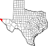 El Paso County map |
| Towns |
| |
| Village |
| |
| CDPs |
| |
| Other unincorporated communities |
| |
| Indian reservation |
| |
Austin (capital) | ||
| Topics |
|  Seal of Texas |
| Society |
| |
| Regions |
| |
| Metropolitan areas |
| |
| Counties | ||
Mayors of cities with populations exceeding 100,000 in Texas | ||
|---|---|---|
| ||
| Authority control |
|
|---|