New York State Thruway
The New York State Thruway (officially the Governor Thomas E. Dewey Thruway and colloquially "the Thruway") is a system of controlled-access highways spanning 569.83 miles (917.05 km) within the U.S. state of New York. It is operated by the New York State Thruway Authority (NYSTA), a New York State public-benefit corporation. The 496.00-mile (798.23 km) mainline is a toll road that extends from the New York City line at Yonkers to the Pennsylvania state line at Ripley by way of Albany, Syracuse, and Buffalo. According to the International Bridge, Tunnel and Turnpike Association, the Thruway is the fifth busiest toll road in the United States.[3]
| |
|---|---|
| Governor Thomas E. Dewey Thruway | |

Map of New York with the Thruway mainline in red; other components of the Thruway system are in blue | |
| Route information | |
| Maintained by NYSTA | |
| Length | 496.00 mi[1] (798.23 km) Mainline only |
| Existed | June 24, 1954[2]–present |
| Component highways | |
| Restrictions | No explosives (including in cargo) between exits 9 and 11 |
| Major junctions | |
| South end | |
| |
| West end | |
| Location | |
| Counties | Westchester, Rockland, Orange, Ulster, Greene, Albany, Schenectady, Montgomery, Herkimer, Oneida, Madison, Onondaga, Cayuga, Seneca, Ontario, Monroe, Genesee, Erie, Chautauqua |
| Highway system | |
| |

A tolled highway connecting the major cities of New York was first proposed as early as the 1940s. The first section of the Thruway, between Utica and Rochester, opened on June 24, 1954. The remainder of the mainline and many of its spurs connecting to highways in other states and Canadian provinces were built in the 1950s. In 1957, much of the Thruway system was included as portions of Interstate 87 (I-87), I-90, and I-95. Other segments became part of I-190 and I-287 shortly afterward. Today, the system comprises six highways: the New York–Ripley mainline, the Berkshire Connector, the Garden State Parkway Connector, the New England Thruway (I-95), the Niagara Thruway (I-190), and the Cross-Westchester Expressway (I-287). The portion of I-84 in New York was maintained by the Thruway Authority from 1991 to 2010, but was never part of the Thruway system and is currently maintained by the New York State Department of Transportation (NYSDOT).
The Thruway utilizes a combination of closed (ticket-based), and all-electronic (open road) tolling. Tickets are used on the Thruway mainline between Harriman and Williamsville and from Lackawanna to the Pennsylvania state line. The Berkshire Connector also utilizes a ticket-based tolling system. The New England Thruway, the Niagara Thruway and the portion of the mainline south/east of Harriman use all-electronic tolling, with tolls paid using either E-ZPass or Tolls-By-Mail. The last two components—the Garden State Parkway Connector and the Cross-Westchester Expressway—and the section of the mainline in and around Buffalo are toll-free. A proposed transition to cashless tolls would eliminate all toll booths and their operators by 2020.[4] The Thruway is partly subsidized by the tolls, whereas other parts are subsidized by NYSDOT, a 50/50 for the toll-free areas, and cashless/tolled areas.
Route description

The New York State Thruway system is a collection of six individual components across the state of New York that connect the state to four neighboring states (Connecticut, Massachusetts, New Jersey, and Pennsylvania) as well as the Canadian province of Ontario. Together, the highways extend for 569.83 miles (917.05 km),[1] making the Thruway system one of the largest toll highway systems in the United States.[5] The longest of the six components is the 496-mile (798 km) mainline. Of the 570 miles in the Thruway system, 560.85 miles (902.60 km) (98.4%) carries at least one Interstate Highway designation.[1] Only three sections of the system are not part of the Interstate Highway System; these are the Garden State Parkway Connector in Rockland County, a 6-mile (10 km) portion of the Berkshire Connector between its western terminus at exit 21A on the mainline near Selkirk and where it joins up with Interstate 90 at exit B1 near Castleton-on-Hudson, and a short section of the mainline within exit 24 in Albany that is located between where I-87 departs the roadway and I-90 enters it. They are designated as New York State Route 982L (NY 982L), NY 912M, and NY 915H, respectively, all unsigned reference routes.[6] The speed limit, enforced by the New York State Police, is 65 miles per hour along most of the Thruway.[7]
I-90, which comprises the bulk of the mainline and the Berkshire Connector, runs for 365.55 miles (588.30 km) along the Thruway: 17.70 miles (28.49 km) as part of the Berkshire Connector and 347.85 miles (559.81 km) on the mainline. I-87 comprises the remaining 148.15 miles (238.42 km) of the mainline, including an 18.86-mile (30.35 km) concurrency with I-287 north of New York City. I-287 covers another 29.76 miles (47.89 km) (including the 18.86 miles (30.35 km) shared with I-87), while I-190 spans 21.24 miles (34.18 km) and I-95 covers 15.01 miles (24.16 km).[1]
All highways maintained by the New York State Thruway Authority (NYSTA) lack the reference markers that exist on all New York State Department of Transportation-maintained roads, as would be expected. In their place, NYSTA-controlled roadways use small, square tenth-mile markers with a white background and blue numbering.[8] These markers differ from the white-on-green reference markers used by NYSDOT on state-maintained highways, which are 10 inches (254 mm) high and 8 inches (203 mm) wide and display a limited amount of mileage information on their third row.[9]
Mainline
South of Albany
The mainline of the Thruway begins, both in terms of exit numbers and mileposts, at the boundary between the New York City borough of the Bronx and the Westchester County city of Yonkers.[1] Here, I-87 changes from the Major Deegan Expressway to the Thruway as the mainline proceeds northward through Yonkers and southern Westchester County. It connects with Central Park Avenue (NY 100) at exit 1, the first of 12 exits within the county. The first few exits serve various local streets, with exit 2 providing access to Yonkers Raceway and exit 3 serving the Cross County Shopping Center. At exit 4, I-87 connects to the Cross County Parkway, an east–west parkway providing access to the Saw Mill River, Bronx River, and Hutchinson River Parkways, all of which run parallel to the Thruway through Yonkers. The Hutchinson River and Bronx River parkways leave to the northeast midway through Yonkers, while the Saw Mill and Sprain Brook Parkways follow the Thruway out of the city.[10] Exit 5 connects to Central Park Avenue which connects towards White Plains. After that, exit 6 connects to Tuckahoe Road, connecting towards Yonkers and Bronxville. The last free exit heading northbound is at Ridge Hill Boulevard and Stew Leonard Drive (exit 6A). Travel further north from there requires a toll payment at the Yonkers toll gantry.

After the toll, the thruway continues to exit 7, which grants access to Arsdley and Saw Mill River Road. All three highways take generally parallel tracks to Elmsford, where I-87 directly intersects the Saw Mill River Parkway at exit 7A. Not far to the north is exit 8, a semi-directional T interchange with I-287 (the Cross-Westchester Expressway). I-287 joins the Thruway here, following I-87 west across the Hudson River into Rockland County on the Tappan Zee Bridge. I-87 and I-287 remain overlapped for 15 miles (24 km) through the densely populated southern portion of Rockland County, meeting the Palisades Interstate Parkway (exit 13) and the Garden State Parkway Connector, the latter of which provides access to the Garden State Parkway (exit 14A) in New Jersey. The Thruway continues generally westward to Suffern, where I-87 and I-287 split at a large semi-directional T interchange (exit 15) near the New Jersey border. At this point, I-287 heads south into New Jersey while I-87 and the Thruway turn northward into the valley of the Ramapo River. NY 17 northbound briefly joins the Thruway at the interchange with I-287 in Suffern, and leaves the Thruway a half mile north at exit 15A in Hillburn.[10]
The Thruway continues north through the river valley toward Harriman, where it encounters the Woodbury toll barrier, the southeastern end of the mainline's major closed ticket system. The barrier is located on the mainline within exit 16 (NY 17), a trumpet interchange. Along with the mainline barrier in Harriman, an electronic toll plaza exists on the exit 16 ramp midway between the Thruway and NY 17 exit 131 (NY 32). Now a completely tolled highway, the Thruway heads northward, roughly paralleling the Hudson River to the river's west as it serves the city of Newburgh, the village of New Paltz, and the city of Kingston, indirectly connecting to the short I-587 in the latter.[10]
Past Kingston, the highway runs closer to the river as it parallels U.S. Route 9W (US 9W) through the towns of Saugerties, Catskill, Coxsackie, and Ravena. Just north of Ravena, the Thruway meets the west end of the Berkshire Connector, a spur linking the Thruway mainline to the Massachusetts Turnpike 25 miles (40 km) to the east. The highway continues into Albany, where it connects to Troy via I-787 at exit 23 and intersects I-90 at exit 24.[10] The latter of the two junctions is the busiest of the Thruway's exits, serving an estimated 27 million vehicles a year.[11] I-87 leaves the Thruway mainline here while I-90 merges into it, following the Thruway northwestward toward Schenectady.[10]
Albany to Syracuse
.jpg)
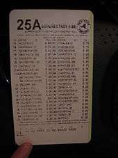
South of Schenectady, but still in Albany County, the Thruway and I-90 meet I-890, a loop route of I-90 that directly serves the downtown district of Schenectady, at exit 25. The Thruway, meanwhile, bypasses the city to the south and west, intersecting I-88 at exit 25A in Rotterdam before reuniting with I-890 at exit 26 west of Scotia. Travel between I-88 (Exit 25A) and exits 24, 25 and 26 in either direction is toll-free.[12] From exit 26 west to Utica, the mainline of the Thruway parallels the Erie Canal and the Mohawk River, crossing over the waterbodies at Mohawk. In between Schenectady and Utica, I-90 and the Thruway serve several riverside communities, including the cities of Amsterdam (exit 27 via NY 30) and Little Falls (exit 29A, NY 169) and the villages of Fonda (exit 28, NY 30A), Canajoharie (exit 29, NY 5S and NY 10), and Mohawk (exit 30, NY 28).[10]
Like Schenectady before it, the Thruway bypasses downtown Utica, following an alignment north of the city while I-790 serves it directly. I-790 breaks from the Thruway at exit 31 and runs along two carriageways flanking the mainline on both sides for 1.5 miles (2.4 km) before turning southward onto the North–South Arterial. The adjacent highways become NY 49, which parallel the Thruway for another 2 miles (3.2 km) northwestward. At the end of this stretch, the Thruway turns slightly southwestward, crossing over the Mohawk River and the Erie Canal while NY 49 continues northwestward along the northern bank of the waterbodies toward Rome. On the other side of the river, the Thruway curves back to the west, proceeding to exit 32 in Westmoreland.[10]

Not far to the west, the Thruway has a junction with NY 365 at exit 33 in Verona. Here, the Thruway connects to the cities of Rome and Oneida and serves the Turning Stone Resort & Casino via NY 365. The highway continues onward through a sparsely populated area between Verona and Syracuse, passing roughly 5 miles (8 km) south of Oneida Lake as it connects to the village of Canastota by way of NY 13 at exit 34. As the highway approaches exit 34A (I-481) outside of Syracuse, the surroundings become more developed. The level of development rises sharply west of I-481 as the Thruway enters Salina, a northern suburb of Syracuse. Within Salina, I-90 and the Thruway intersect I-81, which connects the Thruway to both downtown Syracuse and Syracuse Hancock International Airport.[10]
Syracuse to Buffalo
West of Salina, the Thruway passes north of Liverpool and Onondaga Lake before intersecting I-690 and its northern continuation, NY 690, at exit 39 in Van Buren. At this point, the amount of development along the Thruway sharply declines as it heads generally westward through a marshy area of Onondaga County. I-90 and the Thruway reconnect to the Erie Canal (here part of the Seneca River) at the western county line. Now in Cayuga County, the highway serves Weedsport via exit 40 and NY 34, exit 41 serving Del Lago Resort and Casino in Tyre, New York and passes north of Port Byron prior to entering Seneca County and the Montezuma National Wildlife Refuge. Here, the canal leaves the Thruway for good, turning northwestward to follow the NY 31 corridor to Rochester and beyond.[10]

The portion of the Thruway between Montezuma and the Rochester area is one of mostly rural nature, with the highway passing through remote, open fields, and for the most part avoiding highly populated areas. Along this stretch, it connects to two cities, both located well to the south of the Thruway: Geneva by way of exit 42 for NY 14 and Canandaigua by way of exit 43 via NY 21. The next exit along the highway, exit 44 for NY 332, also serves Canandaigua; the junction is the primary exit for Canandaigua-bound travelers from the Rochester area. Here, the Thruway temporarily widens from four to six lanes as it continues generally westward to meet I-490 at exit 45 near Victor. Like in the vicinity of Schenectady and Utica, an auxiliary route of I-90—here I-490—directly serves a city (Rochester) while the Thruway bypasses it.[10]
It heads northwestward through the city's southern, mostly rural suburbs to Henrietta, where it meets I-390 at exit 46. Henrietta is as close as the Thruway gets to downtown as it proceeds west to Le Roy, where I-490 reconnects to I-90 at exit 47. I-90 continues onward into Genesee County, intersecting with NY 98 at exit 48 north of Batavia and NY 77 at exit 48A in Pembroke. The latter exit provides access to Darien Lake, a large amusement park located in the town of Darien. I-90 and the Thruway continue into Erie County and the Buffalo area. It meets NY 78 at exit 49 near Depew before passing through the Williamsville toll barrier, the northwestern end of the major closed ticket system.[10]
West of Buffalo

Just west of the toll barrier, I-90 and the Thruway—now toll-free—connect to I-290 via exit 50, a semi-directional T interchange. At this point, the Thruway turns southward, passing through the immediate eastern suburbs of Buffalo. As it heads south, it meets the Kensington Expressway (NY 33) at exit 51 and Walden Avenue at exit 52, both cloverleaf interchanges. At exit 52, it passes to the west of the Walden Galleria, a shopping mall situated at the nearby junction of Walden Avenue and NY 277. Two exits later in southern Cheektowaga, I-90 meets I-190, a spur route leading to downtown Buffalo and Niagara Falls, at exit 53.[10]
South of the city, the Thruway meets the Aurora Expressway (NY 400) and the Southern Expressway (US 219) at exits 54 and 55, respectively, in West Seneca. Just southwest of exit 55, I-90 and the Thruway pass through the Lackawanna toll barrier, which serves as the northeast end of the minor closed ticket system. Once again a toll road, the Thruway heads southwestward, roughly paralleling the shoreline of Lake Erie to Blasdell, where it connects to NY 179 (the Milestrip Expressway). Farther southwestward, the Thruway is joined by US 20, which follows a parallel routing to that of the Thruway to the Pennsylvania state line.[10]
As the route passes from Erie County to Chautauqua County, the last on its routing, it cuts through the northwestern portion of the Cattaraugus Indian Reservation, situated on Cattaraugus Creek. The Thruway continues alongside US 20 past Dunkirk and Westfield to the Ripley toll barrier, the southwestern end of the minor closed ticket system just northeast of exit 61 for Shortman Road. Travelers heading eastbound from Pennsylvania can access Shortman Road toll-free. The Thruway ends about 1 mile (1.6 km) after exit 61 at the Pennsylvania state line. I-90, however, continues onward into Pennsylvania as a toll-free highway.[10]
Berkshire Connector
The Berkshire Connector is a 24.28-mile (39.07 km) east–west spur connecting the Thruway mainline in Coeymans to the Massachusetts Turnpike at the Massachusetts state line in Canaan.[1] It is tolled as part of the closed ticket system in place on the mainline between exits 16 and 50. The highway begins at exit 21A off the Thruway southwest of Selkirk in the town of Coeymans (south of Albany)[13] as NY 912M, an unsigned reference route.[6] It proceeds eastward over the Hudson River and into Rensselaer County by way of the Castleton-on-Hudson Bridge. It navigates through the southern, rural portion of the county to exit B1 in Schodack, where the connector meets I-90.[13] The unsigned NY 912M designation terminates here while I-90 joins the Berkshire Connector and follows the spur east into Columbia County.[6][13]
While the Rensselaer County segment follows a mostly east–west routing, the Berkshire Connector in Columbia County takes on a northwest-southeast alignment as the roadway heads towards exit B2 in East Chatham. The junction serves as the northern terminus of the Taconic State Parkway, which connects the spur to the New York City area. About 2 miles (3.2 km) to the southeast is the Canaan toll barrier, which marks the end of the Thruway ticket system. The last exit on the Berkshire Connector is exit B3 for NY 22 just west of the Massachusetts state line in Canaan. The spur continues east to the state line, where it becomes the Massachusetts Turnpike.[13]
Garden State Parkway Connector
The Garden State Parkway Connector is a 2.40-mile (3.86 km) highway that connects the Thruway mainline at exit 14A in Ramapo with the Garden State Parkway at the New Jersey state line.[1] It is designated as NY 982L, an unsigned reference route.[6] The highway begins, in terms of mileposts, at Thruway (I-87 and I-287) exit 14A in Ramapo and heads generally southwestward as a toll-free highway toward the state line. Just north of the state line, the southbound connector meets Red Schoolhouse Road (County Route 41 or CR 41) at a partial diamond interchange. All southbound commercial traffic is forced to exit here as the Garden State Parkway prohibits commercial traffic north of exit 105. Thus, the final 0.31 miles (0.50 km) of the road south of the Red Schoolhouse Road exit is the only part of the Thruway system that prohibits commercial vehicles.[1][14] The connector continues to the state line, where it becomes the tolled Garden State Parkway.
Other components
The New York State Thruway system also consists of three other components: the New England Thruway, the Cross-Westchester Expressway, and the Niagara Thruway. The New England Thruway (NET) is a 15.01-mile (24.16 km) section of Interstate 95 under the operation and maintenance of the New York State Thruway Authority. It begins at the Pelham Parkway interchange (exit 8) in the Co-op City section of the Bronx and continues northeastward into Westchester County to the Connecticut state line, where it connects to the Connecticut Turnpike. The Cross-Westchester Expressway, part of I-287, begins at I-87 exit 8 in Elmsford, where I-287 splits from the Thruway mainline, and travels east across Westchester County to I-95, with connections to both the New England Thruway and the Connecticut Turnpike at exit 12 in Rye. The Niagara Thruway comprises the first 21.24 miles (34.18 km) of I-190 from I-90 in Buffalo to NY 384 in Niagara Falls.[1]
History
Origins and construction
A toll superhighway connecting the major cities of the state of New York that would become part of a larger nationwide highway network was proposed as early as 1949. The following year, the New York State Legislature passed the Thruway Authority Act creating the New York State Thruway Authority (NYSTA), an independent public corporation, which would build and manage the Thruway. The project was to be financed through toll revenue bonds and self-liquidating by receipt of tolls, rents, concessions, and other income. The act also stipulated NYSTA adopt a hybrid system of tolls, with barrier tolls collected in urban areas, and long-distance tickets issued in rural areas.[15]
The first section of the Thruway, between Utica and Rochester, opened on June 24, 1954.[2] Other sections of the 426-mile (686 km) mainline between Buffalo and the Bronx were completed and opened throughout 1954 and 1955. The last segment, from Yonkers south to the Bronx, was completed on August 31, 1956. The total cost was $600 million (equivalent to $4.32 billion in 2018), financed by the sale of $972 million in bonds (equivalent to $7 billion in 2018).[15][16] At the time, it was the longest toll road in the world. In 1957, the mainline was extended 70 miles (113 km) west from Buffalo along Lake Erie to the Pennsylvania state line.
From 1957 to 1960, several spurs of the road were built to connect the road to turnpikes in adjacent states. These include the Berkshire Connector (May 26, 1959), which connects to the Massachusetts Turnpike, the New England Thruway (October 31, 1958) and Cross Westchester Expressway (December 1, 1960), which both connect to the Connecticut Turnpike, and the Niagara Thruway (July 30, 1959), which connects to Canada’s Queen Elizabeth Way via a border crossing near Niagara Falls.[15] The Thruway also directly connects to New Jersey’s tolled Garden State Parkway, which eventually connects to the New Jersey Turnpike, which is part of a toll road system linking New York City and Chicago that also uses tolled highways in Pennsylvania, Ohio, and Indiana.
On August 14, 1957, the segment of the mainline between the Pennsylvania border and the Adirondack Northway in Albany became part of I-90 while the portions from the Northway south to Newburgh and from Elmsford south to the New York City line were included in I-87. Between Elmsford and Newburgh, I-87 followed I-287, what is now I-684, and I-84. Upon its completion, the Berkshire Connector east of US 9 also became part of I-90, creating a gap in the I-90 designation around Albany until the completion of the 20-mile-long (32 km) Albany-Schodack Freeway in the early 1970s, which is not part of the Thruway system. The entirety of the New England Thruway became part of I-95 upon completion while the Niagara Thruway became I-90N in 1957 when it was built through Downtown Buffalo, and later I-190 in 1959 upon completion.[17][18] The Elmsford–Suffern section of the mainline was designated as part of I-287 upon completion of the Cross Westchester Expressway (also I-287) in 1960.[18] The last section of the mainline to receive a designation—from Suffern to Newburgh—finally received one on January 1, 1970, when I-87 was realigned to follow the Thruway for its entire length south of Albany and the former portion of I-87 between White Plains and Brewster became I-684.[19]
The highway was unique in that original signage utilized dark blue backgrounds, the same color blue as displayed on the New York state flag. Over time, these signs were replaced with Federal Highway Administration (FHWA)-approved green backgrounds.[15]
Tappan Zee Bridge replacement
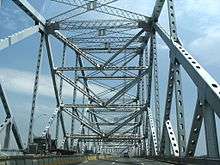
The original Tappan Zee Bridge, carrying the concurrency of the New York State Thruway, I-87, and I-287, was a cantilever bridge built during 1952–55. The bridge was three miles (4.8 km) long and spanned the Hudson at its second-widest point. Before its replacement in 2017, the deteriorating structure carried an average of 138,000 vehicles per day, substantially more traffic than its designed capacity. During its first decade, the bridge carried fewer than 40,000 vehicles per day. Part of the justification for replacing the bridge stems from its construction immediately following the Korean War on a low budget of only $81 million. Unlike other major bridges in metropolitan New York, the Tappan Zee was designed to last only 50 years.[20] The Federal Highway Administration issued a report in October 2011 designating the Tappan Zee's replacement to be a dual-span twin bridge.[21]
Construction officially began in October 2013,[22][23] with the new spans being built to the north of the existing bridge. The new bridge connects to the existing highway approaches of I-87 and I-287 on both river banks.[21] The northbound/westbound span opened on August 25, 2017.[24][25] Southbound/eastbound traffic remained on the old bridge until October 6, 2017. At that point, southbound/eastbound traffic shifted to the westbound span of the new bridge and the old bridge closed.[26][27] The bridge's eastbound span opened to traffic on September 11, 2018.[28][29] Upon completion, the new Tappan Zee Bridge became one of the longest cable-stayed spans in the nation.[30]
Other developments

In 1964, the New York State Legislature officially renamed the Thruway in honor of Thomas E. Dewey, the Governor of New York at the time of the Thruway's opening. The official designation is, however, rarely used in reference to the road.[31]
The Schoharie Creek Bridge was a Thruway bridge over the Schoharie Creek near Fort Hunter and the Mohawk River. On April 5, 1987, it collapsed due to bridge scour at the foundations after a record rainfall. At the time of the collapse, one car and one tractor-semitrailer were on the bridge. Before the road could be blocked off three more cars drove into the gap, the collapse killed ten people.[32][33] The replacement bridge was completed and fully open to traffic on May 21, 1988.[34]
In August 1993, NYSTA became the first agency to implement the E-ZPass electronic toll collection system.[15] By December 1996, it was implemented at all of the Thruway's fixed-toll barriers and at exits along the Berkshire Connector and the New York City–Buffalo section of the mainline.[35] E-ZPass was installed at all of the mainline exits by March 1998.[36] On May 14, 2010, a new E-ZPass configuration, consisting of two highway speed E-ZPass lanes in each direction, became operational at the Woodbury toll plaza, with concrete barriers separating the faster traffic from the staffed toll lanes necessary for vehicles not equipped for E-ZPass.[37]
In 1999 NYSDOT, the Federal Highway Administration and NYSTA discussed making the entire Berkshire Connector part of I-90 and redesignating the non-toll part of I-90 from Thruway exit 24 to exit B1 as I-88. The Thruway main line would be designated as both I-90 and I-88 between exits 25A and 24, and as I-90 and I-87 from exit 24 to exit 21A. This was never implemented, as FHA wished to preserve the I-88 numbering for a potential future corridor connecting Albany and northern interior New England.[38]
When I-84 was built through the Newburgh area in the early 1960s,[39][40] no interchange was built between I-84 and the Thruway. Instead, the connection was made via a short segment of NY 300, which both I-84 and I-87 meet via interchanges.[41] Construction on a direct connection between the Thruway mainline and I-84 began in August 2003.[42] The portion of the exit carrying traffic from I-84 to the Thruway was opened in July 2009. The opposite direction was opened two months later on September 23.[43] The connection allows cars to travel between I-87, I-84 and NY 300 via splits in the ramp.[44]
In late 2018, ramp meters were installed on all entrance ramps to the Thruway mainline in Westchester County (exits 1-9) and at all entrances to the entire Cross-Westchester Expressway. Ramp meters are planned to be installed at all entrances to the mainline in Rockland County (exits 10-15A) in 2020.[45]
Services
There are 27 service areas along the Thruway, all on the New York–Ripley mainline. The service areas, called "travel plazas" by the New York State Thruway Authority (NYSTA), are spaced roughly 30 miles (48 km) apart and are open at all hours of the day. Two plazas—the New Baltimore plaza at milepost 127 and the Angola plaza at milepost 447—are accessible from both directions of the Thruway; the remainder are accessible from only one direction (although the Sloatsburg and Ramapo service plazas at milepost 33 are connected via a pedestrian bridge). Each plaza features a gas station and a variety of restaurants, at least one of which is open 24 hours.[46] Free Wi-Fi service was added to all 27 service areas on March 1, 2007.[47]
NYSTA also operates the Thruway Authority Highway Advisory Radio (HAR) system, a network of radio stations across the state that broadcast information on traffic conditions along the Thruway. The system broadcasts at 1610 AM in the Buffalo, Rochester, Albany, Kingston, and Newburgh areas, 1620 AM in the Finger Lakes and Syracuse areas, 530 AM in the New York City metropolitan area, 540 AM in the vicinity of Utica, and at 98.7 FM in Chautauqua County. HAR is also used to broadcast Amber/Silver Alerts if one is issued.[48]
Travel plazas
| Name | Location | Direction | Milepost | Services |
|---|---|---|---|---|
| Ardsley | Greenburgh | Northbound | 6.0 miles (9.7 km) | Burger King, E-ZPass On-the-Go, Popeyes, Starbucks, Sunoco, Travel Mart |
| Sloatsburg | Sloatsburg | Northbound | 33.0 miles (53.1 km) | Burger King, Dunkin' Donuts, E-ZPass On-the-Go, Mix Candy Shop, Sbarro, Starbucks, Sunoco, TDD, tourism information, Travel Mart |
| Ramapo | Southbound | Carvel, high-speed EV charging station, Lavazza, McDonald's, Sunoco, Uno Pizzeria & Grill | ||
| Plattekill | Newburgh | Northbound | 65.0 miles (104.6 km) | Brioche Dorée, E-ZPass On-the-Go, farm market (seasonal), high-speed EV charging station, Nathan's, Roy Rogers, Starbucks, Sunoco, TDD, tourism information, Travel Mart |
| Modena | Southbound | 66.0 miles (106.2 km) | Carvel, E-ZPass On-the-Go, farm market (seasonal), gift shop, high-speed EV charging station, Lavazza, McDonald's, Moe's Southwest Grill, Sunoco, Uno Pizzeria & Grill | |
| Ulster | Ulster | Southbound | 96.0 miles (154.5 km) | Burger King, E-ZPass On-the-Go, farm market (seasonal), high-speed EV charging station, Nathan's, Pizza Hut Express, Starbucks, Sunoco, Travel Mart |
| Malden | Saugerties | Northbound | 103.0 miles (165.8 km) | E-ZPass On-the Go, farm market (seasonal), Gift shop with deli, Gourmet Cup, high-speed EV charging station, McDonald's, Mobil, Original Pizza of Boston, Sandella's |
| New Baltimore | New Baltimore | Both | 127.0 miles (204.4 km) | Auntie Anne's, E-ZPass On-the-Go, Famous Famiglia, farm market (seasonal), Mobil, Quiznos, Roy Rogers, Starbucks, tourism information, Travel Mart |
| Guiderland | Guilderland | Eastbound | 159.0 miles (255.9 km) | E-ZPass On-the-Go, farm market (seasonal), gift shop, McDonald's, Mobil, Original Pizza of Boston |
| Pattersonville | Florida | Westbound | 168.0 miles (270.4 km) | Auntie Anne's, E-ZPass On-the-Go, farm market (seasonal), MKT Pattersonville, Mobil, Roy Rogers, Starbucks, Taste NY Store, Travel Mart |
| Mohawk | Eastbound | 172.0 miles (276.8 km) | Dippin' Dots, E-ZPass On-the-Go, gift shop, McDonald's, Mobil | |
| Iroquois | Danube | Westbound | 210.0 miles (338.0 km) | Burger King, Dunkin' Donuts, E-ZPass On-the-Go, farm market (seasonal), Mobil, snack bar (seasonal), Travel Mart |
| Indian Castle | Eastbound | The Driver's Lounge, E-ZPass On-the-Go, farm market (seasonal), Hershey's Ice Cream (seasonal), Mobil, Nathan's (seasonal), Roy Rogers, Starbucks, Travel Mart | ||
| Schuyler | Schuyler | Westbound | 227.0 miles (365.3 km) | Breyers, E-ZPass On-the-Go, gift shop, McDonald's, Mobil |
| Oneida | Westmoreland | Eastbound | 244.0 miles (392.7 km) | Burger King, E-ZPass On-the-Go, farm market (seasonal), Sbarro, Starbucks, Sunoco, Travel Mart |
| Chittenango | Sullivan | Westbound | 266.0 miles (428.1 km) | E-ZPass On-the-Go, Sbarro, Starbucks, Sunoco, Travel Mart |
| DeWitt | De Witt | Eastbound | 280.0 miles (450.6 km) | E-ZPass On-the-Go, Edy's, gift shop, McDonald's, Sunoco |
| Warners | Van Buren | Westbound | 292.0 miles (469.9 km) | E-ZPass On-the-Go, farm market (seasonal), gift shop, McDonald's, Mobil, Original Pizza of Boston, Paulie's Pretzels, tourism information (seasonal) |
| Port Byron | Montezuma | Eastbound | 310.0 miles (498.9 km) | E-ZPass On-the-Go, Edy's, farm market (seasonal), gift shop, McDonald's, Mobil, Original Pizza of Boston |
| Junius Ponds | Junius | Westbound | 324.0 miles (521.4 km) | Dunkin' Donuts, E-ZPass On-the-Go, farm market (seasonal), Roy Rogers, Sunoco, TDD, Travel Mart |
| Clifton Springs | Manchester | Eastbound | 337.0 miles (542.3 km) | Burger King, E-ZPass On-the-Go, farm market (seasonal), Sbarro, Starbucks, Sunoco, Travel Mart |
| Seneca | Victor | Westbound | 350.0 miles (563.3 km) | Checkers, E-ZPass On-the-Go, farm market (seasonal), gift shop, Mobil, Tim Hortons, tourism information (seasonal), Villa Italian Kitchen |
| Scottsville | Henrietta | Eastbound | 366.0 miles (589.0 km) | Arby's, E-ZPass On-the-Go, farm market (seasonal), gift shop, Mobil, Tim Hortons, tourism information (seasonal) |
| Ontario | Le Roy | Westbound | 376.0 miles (605.1 km) | Convenience store/gift shop with deli, E-ZPass On-the-Go, Edy's, farm market (seasonal), Lavazza, McDonald's, Original Pizza of Boston, Sunoco |
| Pembroke | Pembroke | Eastbound | 397.0 miles (638.9 km) | Checkers, E-ZPass On-the-Go, farm market (seasonal), gift shop, Sunoco, Taste NY Store (seasonal), Tim Hortons, tourism information (seasonal), Villa International Kitchen (seasonal) |
| Clarence | Lancaster | Westbound | 412.0 miles (663.0 km) | Arby's, E-ZPass On-the-Go, farm market (seasonal), gift shop, Sunoco, TDD, Tim Hortons, tourism information |
| Angola | Evans | Both | 447.0 miles (719.4 km) | Auntie Anne's, Carvel, Cinnabon, E-ZPass On-the-Go, Ella's Pizza and Pasta, gift shop, Lavazza, McDonald's, Moe's Southwest Grill, Sandella's, Subway, Sunoco, tourism information |
Tolls
Collection methods
All components of the New York State Thruway system except for the Garden State Parkway Connector and the Cross-Westchester Expressway are tolled in some capacity. The New York–Ripley mainline employs both an all-electronic, open road tolling system and a closed, ticket-based tolling system. From the New York City line to the NY 17 exit near Harriman, there are three toll gantries that use all-electronic tolling at highway speeds, with tolls collected by E-ZPass or Tolls by Mail.[49][50] From there northward, a closed system is employed where drivers must obtain tickets which show their point of entry and the cost of traveling from there to their desired point of exit. Upon exiting the Thruway, the ticket must be surrendered and the appropriate toll must be paid.[49][51] Two separate closed systems are used on the Thruway mainline, encompassing all of the mainline between Harriman and the Pennsylvania state line except for a section in and around Buffalo.[49]
The southernmost of the three toll gantries is the Yonkers toll gantry, a bi-directional gantry between exits 6A and 7 in Yonkers. In South Nyack, there is a southbound-only toll gantry for the Tappan Zee Bridge. Lastly, there is a northbound, commercial traffic-only gantry in Spring Valley.[50] The closed ticket system originally began at Spring Valley [51] but was moved to exit 16 on March 3, 1974, allowing interchanges along the Thruway in Rockland County to be free of tolls. The toll plaza at Suffern was dismantled along with this change.[52] On April 23, 2016, the southbound toll plaza at the Tappan Zee Bridge in Westchester County was closed and replaced with an southbound all-electronic toll gantry on the Rockland County side of the bridge. In late 2018, all remaining flat-rate toll barriers on the Thruway were replaced with electronic toll gantries.[53] At Harriman, the longer of the two closed, ticket-based systems begins and extends from NY 17 to just east of exit 50 in Amherst. The Berkshire Connector is enclosed within this ticket system, so traveling between the mainline and the connector via exit 21A does not involve crossing a toll barrier, and the connector's exits up to the toll barrier at exit B3 are listed with the mainline exits on tickets for the major closed system. The other system encompasses the portion of the mainline between exit 56 south of Buffalo and exit 61 near the Pennsylvania state line.[49]
To distinguish between exit 16 and the Woodbury toll barrier, Thruway tickets list the NY 17 interchange as exit 16 and the Woodbury toll plaza as exit 15, although the actual exit 15 is situated almost 15 miles (24 km) to the south.[49] Northbound traffic on I-87 traveling through the Woodbury toll barrier is given a ticket while travelers on southbound I-87 must surrender their ticket and pay the appropriate toll. Traffic heading south on I-87 and exiting at exit 16 must pay the appropriate toll for exit 16 at the Harriman toll plaza. Similarly, traffic heading north on I-87 and exiting at exit 16 are charged a fixed-rate toll electronically at the Harriman toll plaza. Traffic entering the Thruway from NY 17 east are charged a toll electronically at the Harriman plaza and, if traveling north, collect a ticket at the Woodbury barrier.[52] (However, this latter situation is less likely to occur because traffic on 17 eastbound is most likely headed south towards New York City, because of 17's south-east gradient beyond Binghamton.) The ticket is identical to that given for exit 15 with the exception that the toll for exit 16 is subtracted from all of the prices.[54][55]
The other components of the system that are tolled have far fewer tolls. On the New England Thruway (I-95), there is a single, fixed-rate toll gantry on I-95 northbound in New Rochelle. Meanwhile, the only tolls along the Niagara Thruway (I-190) are those for major bridges along the highway, namely the North and South Grand Island Bridges.[50]
In March 2020 due to the 2019–20 coronavirus pandemic, anyone who has to pay cash will instead be sent a bill in the mail. Motorists without an E-ZPass will continue through without collecting a ticket. When the motorists exits, they will inform the toll collector where they entered the Thruway and provide their license plate information.[56]
Cost
When the Thruway opened in the mid-1950s, the cost to travel from Buffalo to New York City was $5.60 (equivalent to $42.00 in 2018). The closed ticket system, which at the time extended from Spring Valley to Williamsville, accounted for $5 of the toll, while the remaining $0.60 was charged at the Yonkers ($0.10) and Tappan Zee ($0.50) toll barriers.[51][16] As of April 2010, this trip costs $24.60: $18.35 for the closed ticket system from Williamsville to Woodbury, $5 for the Tappan Zee Bridge, and $1.25 for the Yonkers toll gantry.[57] After the south end of the major closed ticket system was moved from Spring Valley to Woodbury, the Spring Valley toll barrier became a fixed-rate toll for both cars and trucks.[52] The toll for cars was removed in July 1997. At the time, the toll was $0.40 (equivalent to $1.00 in 2018).[16][58]
As of April 2010, the Berkshire Connector costs $0.85 to travel between the Massachusetts state line and exit B1. Tolls west of exit B1 vary based on which direction a motorist travels on I-87.[59] The toll on the minor closed ticket system from Pennsylvania to exit 55 south of Buffalo is $3.15.[60] On I-190, the Grand Island Bridges cost $1 to cross while the New Rochelle toll gantry on I-95 costs $1.75 to pass through.[50] The Black Rock and City Line toll barriers on the Niagara Thruway in Buffalo charged $0.75 at the time of their removal on October 30, 2006.[61]
All tolls along the Thruway were supposed to be abolished when the construction bonds used to build it had been paid off.[62] The last of the bonds was paid off in 1996; however, the tolls remained in place after the New York State Legislature transferred ownership of the New York State Canal System to NYSTA in 1992.[63]
Exit list
For exits on the Cross-Westchester Expressway, the New England Thruway, or the Niagara Thruway, see the articles on those highways.
Mainline
| County | Location[64] | mi[1] | km | Exit[1] | Destinations[1] | Notes |
|---|---|---|---|---|---|---|
| Westchester | Yonkers | 0.00 | 0.00 | – | Southern terminus; I-87 continues south into New York City as the toll-free Major Deegan Expressway. | |
| 0.48 | 0.77 | 1 | Hall Place / McLean Avenue | No northbound signage for McLean Avenue | ||
| 0.92 | 1.48 | 2 | Yonkers Avenue – Yonkers Raceway | Northbound exit and southbound entrance; other movements via exit 4 | ||
| 1.77 | 2.85 | 3 | Mile Square Road | Northbound exit and southbound entrance; other movements via exit 4 | ||
| 2.18 | 3.51 | 4 | Cloverleaf interchange with Central Park Avenue; exits 4N-S on Cross County Parkway | |||
| 2.70 | 4.35 | 5 | Northbound exit and southbound entrance; southern terminus of NY 100 | |||
| 4.00 | 6.44 | 6 | Signed as exits 6E (east) and 6W (west) southbound | |||
| 5.14 | 8.27 | 6A | Ridge Hill Boulevard / Stew Leonard Drive | |||
| 5.47 | 8.80 | Yonkers Toll Gantry (no cash) | ||||
| Greenburgh | 6.10 | 9.82 | Ardsley Service Area (northbound) | |||
| Ardsley | 7.58 | 12.20 | 7 | Northbound exit and southbound entrance | ||
| Elmsford | 10.33 | 16.62 | 7A | Northbound exit and entrance; other movements via exit 8 | ||
| Southbound exit only; other movements via exit 8 | ||||||
| 10.50 | 16.90 | 8 | Southern terminus of I-287 concurrency; signed as exits 8 (I-287) and 8A (NY 119 / Saw Mill) southbound | |||
| Tarrytown | 12.65 | 20.36 | 9 | NY 119 not signed | ||
| Hudson River | 12.80– 14.50 | 20.60– 23.34 | Tappan Zee (Governor Mario M. Cuomo) Bridge | |||
| Rockland | South Nyack | 14.76 | 23.75 | Tappan Zee Bridge Toll Gantry (E-ZPass or Toll by Mail, southbound only[65]) | ||
| 16.49 | 26.54 | 10 | No southbound exit | |||
| Nyack | 17.63 | 28.37 | 11 | NY 59 not signed | ||
| West Nyack | 18.76 | 30.19 | 12 | |||
| 20.94 | 33.70 | 13 | Signed as exit 13N (north) and exit 13S (south); exits 9E-W on Palisades Parkway | |||
| Nanuet | 22.80 | 36.69 | 14 | |||
| 23.00 | 37.01 | – | Southbound entrance only | |||
| Spring Valley | 23.53 | 37.87 | 14A | Access via Garden State Parkway Connector | ||
| 24.31 | 39.12 | Spring Valley Toll Gantry (E-ZPass or Toll by Mail, northbound only) | ||||
| Airmont | 27.62 | 44.45 | 14B | Access to Good Samaritan Regional Medical Center; To NY 59; exit opened February 28, 1974[66] | ||
| Suffern | 30.17 | 48.55 | 15 | Northern terminus of I-287 concurrency; southern terminus of NY 17 concurrency | ||
| 31.35 | 50.45 | 15A | Northern terminus of NY 17 concurrency | |||
| Sloatsburg | 33.20 | 53.43 | Sloatsburg-Ramapo Service Area | |||
| Orange | Harriman | 45.00 | 72.42 | 16 | Harriman Toll Barrier; also serves NY 32; NY 17 is Future I-86. Now an electronic toll exit | |
| Woodbury Toll Barrier (Southern end of ticketed system) | ||||||
| Newburgh | 60.10 | 96.72 | 17 | Exit 36A on I-84 | ||
| 64.8– 65.9 | 104.3– 106.1 | Plattekill-Modena Service Area | ||||
| Ulster | New Paltz | 76.01 | 122.33 | 18 | ||
| Ulster | 91.37 | 147.05 | 19 | Also Serves I-587 and US 209 | ||
| 96.30 | 154.98 | Ulster Service Area (southbound) | ||||
| Saugerties | 101.25 | 162.95 | 20 | Woodstock appears only on southbound signage; also serves NY 212 | ||
| 103.20 | 166.08 | Malden Service Area (northbound) | ||||
| Greene | Catskill | 113.89 | 183.29 | 21 | Via CR 23B | |
| New Baltimore | 124.53 | 200.41 | 21B | |||
| 127.30 | 204.87 | New Baltimore Service Area / Capital Region Welcome Center | ||||
| Albany | Selkirk | 133.60 | 215.01 | 21A | Access via Berkshire Connector | |
| 134.93 | 217.15 | 22 | ||||
| Albany | 141.92 | 228.40 | 23 | Southern terminus of I-787; also serves Times Union Center | ||
| 148.15 | 238.42 | 24 | Signage changes from north-south to east-west; northern terminus of I-87 concurrency; eastern terminus of I-90 concurrency; also serves US 20, Crossgates Mall, & UAlbany | |||
| Guilderland | 152.80 | 245.91 | Guilderland Service Area (eastbound) | |||
| Schenectady | Rotterdam | 153.83 | 247.57 | 25 | Eastern terminus of I-890 | |
| 158.82 | 255.60 | 25A | Eastern terminus of Interstate 88 | |||
| 162.22 | 261.07 | 26 | Exit opened August 12, 1955[67] | |||
| 168.20 | 270.69 | Pattersonville Service Area (westbound) | ||||
| Montgomery | Amsterdam | 171.80 | 276.49 | Mohawk Service Area (eastbound) | ||
| 173.59 | 279.37 | 27 | ||||
| Fultonville | 182.17 | 293.17 | 28 | |||
| Root | 311.40 | 501.15 | Fultonville Rest Area / Mowhawk Valley Welcome Center (westbound) | |||
| Town of Canajoharie | 194.10 | 312.37 | 29 | Also Serves NY 5S | ||
| Herkimer | Danube | 209.90 | 337.80 | Indian Castle-Iroquois Service Area | ||
| 210.62 | 338.96 | 29A | ||||
| Village of Herkimer | 219.70 | 353.57 | 30 | |||
| Schuyler | 227.00 | 365.32 | Schuyler Service Area (westbound) | |||
| Oneida | Utica | 232.85 | 374.74 | 31 | Rome only appears on westbound signage. Eastern terminus of Interstate 790 | |
| Westmoreland | 243.37 | 391.67 | 32 | Rome only appears on westbound signage | ||
| 244.00 | 392.68 | Oneida Service Area (eastbound) | ||||
| Verona | 252.71 | 406.70 | 33 | Rome only appears on eastbound signage; Oneida only appears on westbound signage | ||
| Madison | Canastota | 261.50 | 420.84 | 34 | Oneida only appears on eastbound signage; Chittenango only appears on westbound signage | |
| Sullivan | 266.20 | 428.41 | Chittenango Service Area (westbound) | |||
| Onondaga | DeWitt | 276.58 | 445.11 | 34A | Exit 6 on I-481; Chittenango only appears on eastbound signage; Oswego only appears on westbound signage | |
| East Syracuse | 278.93 | 448.89 | 35 | |||
| 279.40 | 449.65 | DeWitt Service Area (eastbound) | ||||
| Syracuse | 282.93 | 455.33 | 36 | Exit 25A on I-81 | ||
| Liverpool | 283.79 | 456.72 | 37 | Electronics Parkway – Liverpool, Syracuse | Syracuse only appears on eastbound signage; Liverpool only appears on westbound signage | |
| 285.95 | 460.19 | 38 | ||||
| Van Buren | 289.53 | 465.95 | 39 | |||
| 291.30 | 468.80 | Warners Service Area (westbound) | ||||
| Cayuga | Brutus | 304.19 | 489.55 | 40 | To NY 31 | |
| Port Byron | 308.30 | 496.16 | Erie Canal Heritage Park (eastbound) | |||
| Montezuma | 310.10 | 499.06 | Port Byron Service Area (eastbound) | |||
| Seneca | Tyre | 320.41 | 515.65 | 41 | ||
| Junius | 323.60 | 520.78 | Junius Ponds Service Area (westbound) | |||
| Ontario | Town of Phelps | 327.10 | 526.42 | 42 | Also serves NY 318 | |
| Town of Manchester | 336.90 | 542.19 | Clifton Springs Service Area (eastbound) | |||
| 340.15 | 547.42 | 43 | ||||
| Farmington | 347.13 | 558.65 | 44 | Victor only appears on westbound signage | ||
| Town of Victor | 349.20 | 561.98 | Seneca Service Area (westbound) | |||
| 350.99 | 564.86 | 45 | Victor only appears on eastbound signage. Eastern terminus of Interstate 490; To NY 96 | |||
| Monroe | Henrietta | 362.44 | 583.29 | 46 | Also serves NY 253 and NY 15 | |
| 365.30 | 587.89 | Scottsville Service Area (eastbound) | ||||
| Genesee | Town of Le Roy | 375.20 | 603.83 | Ontario Service Area (westbound) | ||
| 378.56 | 609.23 | 47 | Western terminus of Interstate 490 | |||
| Town of Batavia | 390.13 | 627.85 | 48 | |||
| 397.00 | 638.91 | Pembroke Service Area (eastbound) | ||||
| Pembroke | 401.72 | 646.51 | 48A | Exit opened on February 25, 1971[68] | ||
| Erie | Clarence | 411.60 | 662.41 | Clarence Service Area (westbound) | ||
| Cheektowaga | 417.27 | 671.53 | 49 | |||
| Williamsville | 419.69 | 675.43 | Williamsville Toll Plaza (Western end of ticketed system) | |||
| Buffalo | 420.34 | 676.47 | 50 | Eastern terminus of Interstate 290 | ||
| 420.93 | 677.42 | 50A | Cleveland Drive | Eastbound exit and westbound entrance | ||
| 421.57 | 678.45 | 51 | Signed as 51E (east) and 51W (west) | |||
| 423.19 | 681.06 | 52 | Walden Avenue – Cheektowaga, Buffalo | Signed as 52E (east) and 52W (west) | ||
| 424.92 | 683.84 | 52A | William Street | |||
| 426.17 | 685.85 | 53 | Southern terminus of Interstate 190 | |||
| 427.94 | 688.70 | 54 | Northern terminus of NY 400 | |||
| West Seneca | 429.47 | 691.16 | 55 | Eastbound entrance from and westbound exit to US 219; full access to and from Ridge Road. Northern terminus of US 219 | ||
| Lackawanna | 430.51 | 692.84 | Lackawanna Toll Plaza (Eastern end of ticketed system) | |||
| Town of Hamburg | 432.45 | 695.96 | 56 | Orchard Park only appears on eastbound signage | ||
| 436.22 | 702.03 | 57 | East Aurora only appears on eastbound signage; ramp access at NY 75 converted from trumpet interchange to at-grade intersection in 2018[69][70] | |||
| Evans | 444.87 | 715.95 | 57A | Eden, Angola | Exit opened October 2, 1972[71] | |
| 446.60 | 718.73 | Angola Service Area | ||||
| Chautauqua | Hanover | 455.54 | 733.12 | 58 | Access to Lakeshore Hospital | |
| Dunkirk | 467.74 | 752.75 | 59 | |||
| Town of Westfield | 485.00 | 780.53 | 60 | |||
| Ripley | 494.51 | 795.84 | Ripley Toll Plaza (Western end of ticketed system) | |||
| 494.92 | 796.50 | 61 | Shortman Road (NY 950D) – Ripley | |||
| 496.00 | 798.23 | – | Western terminus; I-90 continues into Pennsylvania as a toll-free highway | |||
1.000 mi = 1.609 km; 1.000 km = 0.621 mi
| ||||||
Berkshire Connector
The Berkshire Connector is a closed-ticket system that extends east from the Thruway mainline to the Canaan Toll Barrier, connecting the mainline Thruway to the Mass Pike.
| County | Location[64] | mi[1] | km | Exit[1] | Destinations[1] | Notes |
|---|---|---|---|---|---|---|
| Albany | Selkirk | 0.00 | 0.00 | – | Exit 21A on mainline Thruway | |
| Hudson River | 0.95[64] | 1.53 | Castleton Bridge | |||
| Rensselaer | Schodack | 6.58 | 10.59 | B1 | Western terminus of concurrency with I-90 | |
| Columbia | Chatham | 15.09 | 24.29 | B2 | Northern terminus of Taconic Parkway | |
| Canaan | 17.83 | 28.69 | Canaan Toll Barrier (eastern terminus of ticketed system) | |||
| 23.27 | 37.45 | B3 | To Route 102 | |||
| 24.28 | 39.07 | – | Continuation into Massachusetts; eastern terminus of concurrency with I-90 | |||
1.000 mi = 1.609 km; 1.000 km = 0.621 mi
| ||||||
Garden State Parkway Connector
The entire route is in Rockland County. [64]All exits are unnumbered.
| Location[64] | mi[1] | km | Destinations[1] | Notes | |
|---|---|---|---|---|---|
| Spring Valley | 0.00 | 0.00 | Exit 14A on the mainline Thruway | ||
| Nanuet | Nanuet | Northbound exit only; access via CR 35 | |||
| Chestnut Ridge | 2.09 | 3.36 | School House Road (CR 41) – Chestnut Ridge | Southbound exit and northbound entrance | |
| 2.40 | 3.86 | Continuation into New Jersey | |||
1.000 mi = 1.609 km; 1.000 km = 0.621 mi
| |||||
See also

- Schoharie Creek Bridge collapse – bridge collapse along the Thruway in 1987
References
- New York State Thruway Authority. "Interchange/Exit Listing with Mileposts". New York State Thruway Authority. Retrieved July 25, 2015.
- Dales, Douglas (June 20, 1954). "Across The Map". The New York Times. pp. XX21.
- Cauchon, Dennis (February 5, 2008). "Drivers to see major toll hikes". USA Today. Retrieved May 31, 2010.
- "Gov. Proposes Eliminating Toll Booths from New York State Thruway by 2020". Syracuse.com.
- New York State Thruway Authority. "New York State Thruway Authority". New York State Thruway Authority. Retrieved October 20, 2010.
- New York State Department of Transportation (January 2012). Official Description of Highway Touring Routes, Bicycling Touring Routes, Scenic Byways, & Commemorative/Memorial Designations in New York State (PDF). New York State Department of Transportation. Retrieved February 16, 2012.
- "History of NY Thruway 1991–2000". Upstate NY Roads. Archived from the original on August 15, 2016. Retrieved June 30, 2016.
- Wing, J.P. (September 8, 2009). "Improved Thruway Guidance, Part 2: Coinciding with the Interstate Designations". Upstate NY Roads. Archived from the original on July 15, 2011. Retrieved November 18, 2010.
- Reference Marker Manual (PDF). New York State Department of Transportation. January 1996. pp. 3–5. Retrieved November 18, 2010.
- "At a transportation crossroad". Times Union. Albany, New York. October 26, 2007. p. 56. Retrieved April 17, 2010.
- New York State Thruway Authority. "Downloadable Toll Schedules". New York State Thruway Authority. Retrieved June 25, 2017.
- New York State Thruway Authority (February 15, 2002). "Commercial Services: TOPS: Invalid Routes". New York State Thruway Authority. Archived from the original on May 27, 2010. Retrieved April 19, 2010.
- Anderson, Steve. "New York State Thruway". NYCRoads. Retrieved April 21, 2010.
- Thomas, Ryland; Williamson, Samuel H. (2019). "What Was the U.S. GDP Then?". MeasuringWorth. Retrieved April 6, 2019. United States Gross Domestic Product deflator figures follow the Measuring Worth series.
- American Association of State Highway Officials (August 14, 1957). Official Route Numbering for the National System of Interstate and Defense Highways (Map). Scale not given. Washington, DC: American Association of State Highway Officials – via Wikimedia Commons.
- Gulf Oil Company; Rand McNally and Company (1960). New York and New Jersey Tourgide Map (Map). Gulf Oil Company.
- State of New York Department of Transportation (January 1, 1970). Official Description of Touring Routes in New York State (PDF). Albany: State of New York Department of Transportation. Retrieved April 19, 2010.
- McGeehan, Patrick (January 17, 2006). "A Bridge That Has Nowhere Left to Go". The New York Times. Retrieved February 27, 2010.
- US Federal Highway Administration (October 13, 2011). "Tappan Zee Hudson River Crossing Project Scoping Information Packet" (PDF). Archived from the original (PDF) on October 30, 2011. Retrieved October 26, 2011.
- "Governor Cuomo Announces Beginning of Formal Construction of the New NY Bridge to Replace Tappan Zee". Office of Governor Andrew M. Cuomo. September 28, 2014. Retrieved August 29, 2017.
- "New Tappan Zee construction starts". New York Post. Associated Press. October 16, 2013. Retrieved August 29, 2017.
- "Opening day on new Tappan Zee Bridge shows sleek design, new features". Retrieved August 27, 2017.
- "Watch drone video of New York's new Tappan Zee Bridge". USA TODAY. Retrieved August 27, 2017.
- "Rockland-bound traffic to begin traveling on new Tappan Zee Bridge". ABC7 New York. August 25, 2017. Retrieved August 27, 2017.
- Adams, Sean (October 6, 2017). "Old Tappan Zee Bridge Sees Its Final Car Friday Night". CBS New York. Retrieved October 13, 2017.
- "Cuomo Bridge second span will open Saturday, enhanced bus service to start Oct. 29". lohud.com. September 4, 2018. Retrieved September 6, 2018.
- "Here's New Tappan Zee Bridge Traffic Shift Info, Timing For Second Span Opening". Greenburgh Daily Voice. January 27, 2018. Retrieved September 6, 2018.
- "New Tappan Zee will be world's widest bridge". Archived from the original on January 9, 2013.
- "Thruway Named for Gov. Dewey; Rockefeller Signs Bill—It Takes Effect in September". The New York Times. February 18, 1964. p. 1. Retrieved August 9, 2009.
- Feld, Jacob; Carper, Kenneth L. (1997). Construction Failure. John Wiley and Sons. ISBN 978-0-471-57477-4.
- "Schoharie Creek Bridge Collapse". Hudson International Group. Retrieved July 30, 2010.
- Croyle, Johnathan (January 4, 2019). "On this date: Thruway bridge collapses into Schoharie Creek in 1987". Syracuse.com. Retrieved April 9, 2020.
- New York State Thruway Authority (2002). "The New York State Thruway: 1991–2000". Thruway Chronology. New York State Thruway Authority. Archived from the original on August 15, 2016. Retrieved November 18, 2010.
- Preston, Jennifer (March 12, 1998). "Installation of E-Z Pass System on Turnpike and Parkway Is Expected to Take 2 Years". The New York Times. Retrieved November 18, 2010.
- New York State Thruway Authority. "Woodbury Mobility Improvement Project". New York State Thruway Authority. Archived from the original on January 9, 2010. Retrieved June 1, 2010.
- Bergman Associates (February 13, 2008). "Hudson River Crossing Study" (PDF). Capital District Transportation Committee and New York State Department of Transportation. p. 22. Archived from the original (PDF) on July 19, 2011. Retrieved December 25, 2009.
- Esso; General Drafting (1962). New York with Sight-Seeing Guide (Map) (1962 ed.). Esso.
- Sinclair Oil; Rand McNally and Company (1964). New York and Metropolitan New York (Map). Sinclair Oil.
- New York State Department of Transportation (1991). Newburgh Digital Raster Quadrangle (Map). 1:24,000. Albany: New York State Department of Transportation. Retrieved April 19, 2010.
- Rife, Judy (August 27, 2003). "Project to Unite I-84, Thruway Gets in Gear". Times Herald-Record. Middletown, Orange County, New York. Retrieved April 22, 2010.
- Rife, Judy (September 22, 2009). "I-84/87 Interchange 90% Done". Times Herald-Record. Middletown, Orange County, New York. Retrieved April 22, 2010.
- Rife, Judy (April 13, 2008). "I-84, Thruway Soon to Meet". Times Herald-Record. Middletown, Orange County, New York. Retrieved April 22, 2010.
- "'Ramp meter' traffic signals now on I-287 to help ease congestion". lohud.com. Retrieved February 24, 2019.
- New York State Thruway Authority. "Thruway Travel Plazas". New York State Thruway Authority. Archived from the original on March 5, 2010. Retrieved April 19, 2010.
- New York State Thruway Authority (March 1, 2007). "Thruway Authority Announces Wi-Fi Availability at Travel Plazas" (Press release). New York State Thruway Authority. Archived from the original on October 10, 2007. Retrieved April 19, 2010.
- New York State Thruway Authority. "Highway Advisory Radio (HAR) Coverage". New York State Thruway Authority. Archived from the original on March 5, 2010. Retrieved April 19, 2010.
- New York State Thruway Authority (2010). "New York State Thruway Toll Schedule" (PDF). New York State Thruway Authority. Archived from the original (PDF) on May 27, 2010. Retrieved April 22, 2010.
- New York State Thruway Authority. "Schedule of Cash Tolls at Fixed Toll Barriers". New York State Thruway Authority. Archived from the original on May 27, 2010. Retrieved April 21, 2010.
- "Collecting The Tolls". The New York Times. June 20, 1954. p. XX10.
- New York State Thruway Authority (2002). "The New York State Thruway: 1971–1980". Thruway Chronology. New York State Thruway Authority. Archived from the original on September 28, 2011. Retrieved November 18, 2010.
- "Governor Cuomo Announces All New York State Thruway Toll Barriers in Lower Hudson Valley Will Convert to Open Road, Cashless Tolling By the End of 2018". Governor Andrew M. Cuomo. June 12, 2018. Retrieved February 24, 2019.
- New York State Thruway Authority. "Toll and Distance Calculator: From Exit 15A to Exit 19". New York State Thruway Authority. Archived from the original on July 21, 2011. Retrieved November 18, 2010.
- New York State Thruway Authority. "Toll and Distance Calculator: From Exit 16 to Exit 19". New York State Thruway Authority. Archived from the original on July 21, 2011. Retrieved November 18, 2010.
- "NYS tolls not collecting cash due to coronavirus concerns; motorists will be billed". Buffalo: WGRZ-TV. March 20, 2020. Retrieved March 20, 2020.
- New York State Thruway Authority. "Toll and Distance Calculator: From Exit 50 to New York City Line". New York State Thruway Authority. Retrieved April 21, 2010.
- "Tappan Zee Car Toll To Rise to $3 in July". The New York Times. January 28, 1997. Retrieved April 13, 2010.
- New York State Thruway Authority. "Toll and Distance Calculator: From Massachusetts State Line to Exit B1". New York State Thruway Authority. Retrieved April 21, 2010.
- New York State Thruway Authority. "Toll and Distance Calculator: From Pennsylvania State Line to Exit 55". New York State Thruway Authority. Retrieved April 21, 2010.
- Fink, James (October 30, 2006). "I-190 Tolls in Rear-View Mirror". Business First of Buffalo. Retrieved April 22, 2010.
- "Panel Studies New Role For Thruway Authority". The New York Times. Associated Press. May 1, 1991. Retrieved April 22, 2010.
- "Highway Robbery on the Thruway". Daily News. New York City. August 20, 1996. Retrieved April 22, 2010.
- Office of Technical Services, Engineering Division (2014). "Inventory Listing". New York State Department of Transportation. Retrieved July 25, 2015.
- Westchester Countyf
- Rockland County
- Orange County
- Ulster County
- Greene County
- Albany County
- Schenectady County
- Montgomery County
- Herkimer County
- Oneida County
- Madison County
- Onondaga County
- Cayuga County
- Seneca County
- Ontario County
- Monroe County
- Genesee County
- Erie County
- Chautauqua County
- Rensselaer County
- Columbia County
- "Fixed Barrier Cash Toll Rates". New York State Thruway Authority. Retrieved October 6, 2014.
- Seltzer, Bob (February 26, 2019). "Airmont Interchange Opening This Sunday". The Journal News. White Plains, New York. p. 17. Retrieved September 21, 2019 – via Newspapers.com.

- "Thruway Interchange at Schenectady Opens". The Rockland County Journal-News. Nyack, New York. p. 14. Retrieved March 26, 2020 – via Newspapers.com.
- "Thruway Connection Opened at Oakfield". The Rochester Democrat and Chronicle. February 26, 1971. p. 3. Retrieved April 25, 2018 – via Newspapers.com.
- "Thruway Authority Announces Start of Bridge Removal Project in the Town of Hamburg" (Press release). New York State Thruway Authority. May 14, 2018. Retrieved September 16, 2019.
- O'Brien, Barbara (April 28, 2017). "How the Thruway Authority Will Change Exit 57 in Hamburg". The Buffalo News. Retrieved September 16, 2019.
- "Thruway Exchange Dedication Monday". The Hamburg Sun. September 28, 1972. p. 4. Retrieved March 26, 2020 – via Newspapers.com.
External links
| Wikimedia Commons has media related to New York State Thruway. |
- New York State Thruway Authority
- Thruway Chronology 1942–2000
- The Thruway's entry in BBC h2g2
- New York Thruway (I-87) (Greater New York Roads)
| Authority control |
|
|---|