Neckar
The Neckar (German pronunciation: [ˈnɛkaʁ] (![]()
| Neckar | |
|---|---|
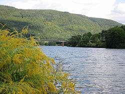 The Neckar near Heidelberg | |
| Location | |
| Country | Germany |
| Physical characteristics | |
| Source | |
| ⁃ location | Black Forest |
| ⁃ elevation | 706 m (2,316 ft) |
| Mouth | |
⁃ location | Rhine |
⁃ coordinates | 49°30′43″N 8°26′14″E |
| Length | 362.4 km (225.2 mi) [1] |
| Basin size | 13,928 km2 (5,378 sq mi) [1] |
| Discharge | |
| ⁃ average | 145 m3/s (5,100 cu ft/s) |
| Basin features | |
| Progression | Rhine→ North Sea |
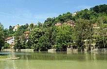
From Plochingen to Stuttgart, the Neckar valley is densely populated and heavily industrialised, with several well-known companies. Between Stuttgart and Lauffen, the Neckar cuts a scenic, meandering, and in many places steep-sided, valley into fossiliferous Triassic limestones and Pleistocene travertine. Along the Neckar's valley in the Odenwald hills many castles can be found, including Hornberg Castle and Guttenberg Castle in Haßmersheim; the now-mothballed Obrigheim Nuclear Power Plant and the active Neckarwestheim Nuclear Power Plant are also located there.

Traditionally the fertile plains have been intensively used for agriculture and its steep valley sides as vineyards.
Ethymology
The name Neckar may be derived from Nicarus and Neccarus from Celtic Nikros, meaning wild water or wild fellow. The grammatical gender of the name in German is masculine (Der Neckar).
Geography
River course
Drainage area

Sources
The headwater region of the Neckar lies in the Schwenninger Moos between Schwenningen and Bad Dürrheim. The traditionally marked spring of the river lies in the city park Möglingshöhe in Schwenningen.
Prior to the Landesgartenschau Villingen-Schwenningen 2010 the Neckar flowed in the city center of Schwenningen mostly underground. In order to protect the city better from the more frequent flooding through overflow of the duct, the river received more space through a new, mostly open riverbed. This riverbed runs largely on the newly constructed horticultural show ground, which was used as the occasion for the remodeling.
Headwaters
Up to shortly before Rottweil the Neckar is only a small streamlet on the Baar plateau. In Deißlingen-Lauffen it has is only, 4 meters high waterfall, which is drained today. Afterwards the Neckar joins with the Eschach coming from the eastern slopes of the black forest which is much more water bearing. Its main tributary Glasbach, which originates at the Brogen, is hydrographically seen, the main river of the Neckar river system.
With this junction above Rottweil the Neckar enters a narrow, wooded valley and for the next 80 km it bores its way towards north between the ranges of the black forest and the Swabian Jura. It has created two cut-off meander spurs at the Neckarburg which is spanned by the Neckarburgbrücke. Further down the river lies high above the river the old town of Oberndorf on a Calcareous sinter terrace, which fills one of the bowl-like side valleys. At Horb it turns from the Gäu Plateau towards north east and then follows the western side of the Swabian Jura (Albtrauf). Near Weitingen the valley is traversed by the 127 m high Neckar Viaduct of the A 81. At Rottenburg it enters the wider valley of Tübingen. After Tübingen the valley narrows again. From here onwards, the surrounding elevated grounds are considerably more densely populated.
Middle reaches
At Plochingen the Neckar turns sharply north west at the „Neckarknie“ (knee of the Neckar), the mouth of the Fils coming down from the east, from the Swabian Jura. Beginning from here the river has been expanded into a canalised waterway. It lies up to Stuttgart in a wide, urbanized meadow, which has been built over with industry and is cut through by transportation structures. Only around the Cannstatter valley bend for a short distance it is interspersed by large park areas. Here again the valley sides show limestone-sinter. Between Stuttgart and Lauffen the Neckar cuts a scenic, meandering, and in many places steep-sided, valley into fossiliferous Triassic limestones and Pleistocene travertine. After Stuttgart it turns again towards the general northern direction. In a winding and narrow valley section through the Ludwigsburg (district) the Rems enters from the right at Remseck and then again from the right north of Marbach the Murr. After passing the Hessigheimer Felsengärten the water-rich Enz enters from the left at Besigheim. The former rapid at the Lauffener avulsion of the meander is today under water due to the canalization. In the Lowlands around Heilbronn the Neckar runs again through a wide meadow an open landscape. At Bad Friedrichshall it takes up within only two kilometers the other two of its large tributaries: First its water-richest tributary, the Kocher and then the officially longest, the Jagst, in total roughly doubling its discharge.
Lower reaches
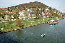
Between Bad Wimpfen with its Stauferpfalz and Mosbach the Neckar enters the Odenwald, where, again in a gorge-like valley, high, elevated, forested slopes line its riverside and especially on the right side, deeply cut valleys enter. At the last of his distinctive knees at Eberbach it turns west, enters at Hirschhorn for a short distance Hessian territory and is then up to Neckarsteinach on long parts the border between Baden-Württemberg and Hessen. At Neckargemünd the Elsenz enters from the left, its lower reaches using a part oft the Neckars former Maurer river loop which extended far south. At the city of Heidelberg, which borders in the north the Odenwald and at the south the Königstuhl (Odenwald), the Neckarvalley is cut in the deepest by over 400m through mountains. After passing the Heidelberger historic city, the river enterst he wide Upper Rhine Plain and after further about 25 kilometers in Mannheim roughly at its middle it enters the Rhine from the right.
Tributaries
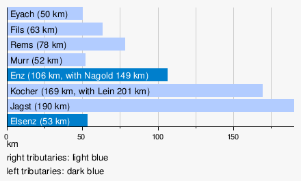
The largest tributaries of the Neckar are the Enz with the larges drainage area, the Kocher with the highest average water drainage and the longest one, the Jagst. The Kocher tributary Lein is at its end not only longer than the Kocher, but also more water-abundant. Therefore, according to hydrographic convention the Lein would have to be regarded as the main river of the Kocher water system, making it with then 201 kilometers the longest tributary of the Neckar.
Diagram of the tributaries with 50 plus km length
Tributaries with 20 km length and more


Named from source to mouth. According to LUBW-BRSWEB, LUBW-FG10, LUBW-GEZG and TK25. Drainage area mostly according to LUBW-GEZG, else measured on the background map. Distances preferably according to the data sets of the LUBW-FG10, rarely measured on the background map. Namen preverably according to TK25.
- Eschach (left tributary at Rottweil-Bühlingen, 38.1 km)
- Prim (right tributary at Rottweil, 21.1 km)
- Schlichem (right tributary at Epfendorf, 34.4 km)
- Glatt (left tributary at Horb-Neckarhausen, 34.2 km)
- Eyach (right tributary at Bf. Eyach, community Eutingen im Gäu, 50.4 km)
- Starzel (right tributary at Rottenburg-Bieringen, 42.8 km)
- Steinlach (right tributary at Tübingen, 25.1 km)
- Ammer (left tributary at Tübingen-Lustnau, 22.5 km)
- Echaz (right tributary at Kirchentellinsfurt, 22.8 km)
- Erms (right tributary at Neckartenzlingen, 32.7 km)
- Aich (left tributary at Nürtingen-Oberensingen, 30.4 km)
- Lauter (right tributary at Wendlingen, 25.7 km)
- Fils (right tributary at Plochingen, 62.8 km)
- Körsch (left tributary west of Deizisau, 26.3 km)
- Rems (right tributary at Remseck, 78.4 km)
- Murr (right tributary at Marbach, 51.5 km)
- Enz (left tributary at Besigheim, 105.5 km)
- Zaber (left tributary at Lauffen, 22.4 km)
- Schozach (right tributary at Heilbronn-Sontheim, 25.6 km)
- Lein (left tributary at Heilbronn-Neckargartach, 27.3 km)
- Sulm (right tributary at Neckarsulm, 26.2 km)
- Kocher (right tributary at Bad Friedrichshall-Kochendorf, 168.7 km)
- Jagst (right tributary at Bad Friedrichshall-Jagstfeld, 190.2 km)
- Elz (right tributary at Mosbach-Neckarelz, 39.8 km)
- Itter (right tributary at Eberbach, 28.0 km)
- Laxbach (right tributary at Hirschhorn, 30.0 km with the longest headwaters)
- Steinach (right tributary at Neckarsteinach, 21.9 km)
- Elsenz (left tributary at Neckargemünd, 53.4 km)
Cities and municipalities
The Neckar touches, from the source to the mouth, the following districts, cities and municipalities:
- Schwarzwald-Baar-Kreis: Villingen-Schwenningen, Dauchingen
- Landkreis Rottweil: Deißlingen, Villingendorf, Rottweil, Epfendorf, Oberndorf am Neckar, Sulz am Neckar
- Landkreis Freudenstadt: Horb am Neckar, Eutingen im Gäu (Weitinger Mühle)
- Landkreis Tübingen: Starzach (municipality districts Börstingen and Sulzau), Rottenburg am Neckar, Tübingen, Kirchentellinsfurt
- Landkreis Reutlingen: Reutlingen (municipality districts Altenburg, Oferdingen and Mittelstadt), Pliezhausen
- Landkreis Esslingen: Neckartenzlingen, Neckartailfingen, Nürtingen, Oberboihingen, Unterensingen, Wendlingen am Neckar, Köngen, Wernau (Neckar), Plochingen, Deizisau, Altbach, Esslingen am Neckar
- Stuttgart (urban district), city districts Obertürkheim, Hedelfingen, Wangen, Untertürkheim, Stuttgart-Ost, Bad Cannstatt, Münster, Hofen, Mühlhausen)
- Rems-Murr-Kreis: Fellbach (municipality district Oeffingen; only right shore)
- Landkreis Ludwigsburg: Remseck am Neckar, Ludwigsburg (municipality districts Poppenweiler, Hoheneck and Neckarweihingen), Marbach am Neckar, Benningen am Neckar, Freiberg am Neckar, Pleidelsheim, Ingersheim, Mundelsheim, Hessigheim, Besigheim, Walheim, Gemmrigheim, Kirchheim am Neckar
- Landkreis Heilbronn: Neckarwestheim, Lauffen am Neckar, Talheim, Nordheim
- Heilbronn (urban district)
- Landkreis Heilbronn: Neckarsulm, Untereisesheim, Bad Friedrichshall, Bad Wimpfen, Offenau, Bad Rappenau (municipality district Heinsheim), Gundelsheim
- Neckar-Odenwald-Kreis: Haßmersheim, Neckarzimmern, Mosbach (municipality districts Neckarelz and Diedesheim), Obrigheim, Binau, Neckargerach, Zwingenberg
- Rhein-Neckar-Kreis: Eberbach, Schönbrunn (Baden)
- Kreis Bergstraße (Hessen): Hirschhorn (Neckar), Neckarsteinach
- Rhein-Neckar-Kreis: Neckargemünd
- Heidelberg (urban district), city districts Schlierbach, Ziegelhausen, Neuenheim, Altstadt, Bergheim, Wieblingen
- Rhein-Neckar-Kreis: Dossenheim (municipality districts Schwabenheim), Edingen-Neckarhausen, Ladenburg, Ilvesheim
- Mannheim (urban district), city districts Seckenheim, Feudenheim, Neuostheim, Oststadt, Neckarstadt-Ost, Innenstadt/Jungbusch, Neckarstadt-West
River history
The primal Neckar started of as an escarpment riverlet due to the slow rise of the black forest and the connected slow erosive retraction oft the south german Scarpland.
For a long time it flowed on the high plains of the different Gäu created through the hard chalks of the Muschelkalk. At Horb the rivers direction was redirected to the northeast due to the rift structure of the so-called Swabian Lineament, which lies roughly parallel to the escarpment of the Swabian Jura. Following that the Neckar cut into the Muschelkalk-plateau between Rottweil and Rottenburg as well as the younger Keuper- and Jura layers in the northeast and created in the area of the morphologially hard chalks and sandstones narrow water gaps.
.JPG)
The river deepening was additionally pushed forward by the further rise of the black forest as well as the retracting erosion of the attacking younger Neckar route. This younger Neckar route tapped the primal Neckar system at plochingen (hence the „Neckarknie”), which did flow through the primal lone to the primal Danube. Influencing in this river area was also the Schurwald, a dissected cuesta oft the filder rift, working as a river guideline.
Today's lower reaches used to be those of the primal Enz. Until, through the erosive retraction of a tributary of the primal Enz near Besigheim, the Neckar river network was tapped. That is how the Enz became a tributary of the Neckar.[2] Another clue of the formerly reaching far north west Danube river network is the Eschach running from north west to south east, hence towards the primal donau. With the retraction of the escarpment it was tapped by a Neckar tributary and redirected by about 90° to the east. Considering river history, she was never a headstream of the Neckar.
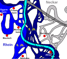
Up until 2000 years ago the Neckar flowed through a pastureland in the Oberrheinische Tiefebene in a tangle of meanders, slings, old waters and cut of arms between the Rhine in the west and the foot of the Odenwald in the east until it finally entered the Rhine only north of Darmstadt at Trebur. Roughly 50 km north of today's mouth in Mannheim. On large stretches you can still see it on aerial photos.
In the 13th century the mouth was south of Mannheim. As a consequence of a large flooding the Neckar redirected itself at about 1275. Since then it enters the Rhine north of the city.[12] The last change here took place in connection with the straightening of the Rhine by the „Friesenheimer Durchstich“ (Friesenheimer breakthrough) west of today's Friesenheimer Island. Before the Neckar entered the Rhine in the area of today's industrial port of Mannheim. Its new riverbed was also the reason for the relocation of the Neckar. After the old Neckar was cut off early 1869, it followed the path of the new Neckar breakthrough, which was finished by 1880.[3]
River landscape
Natural landscape
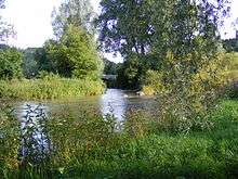
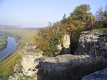
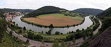
Narrow and widening valleys alternate along the Neckar's course. The narrows are mostly deepenings into the Muschelkalk plateau and the Buntsandstein below. Widenings developed in the area of morphologically soft clay and marl. Wide valley meadows also developed through the strong backfilling with Aue clay since the start of settlement in the Neolithic and the accompanying deforestation and soil erosion. In the area of the narrows the meander and cut-off meander spurs stand out. The meanders were formed through the primal Neckar, which sluggishly flowed through the almost even Muschelkalk plateau, forming the basic structures during the deepening phases and cutting into the hard Muschelkalk. The best known cut-off meander spur is the one at Lauffen; it cut through in historical times and created a waterfall (historic: Laufen). At the cutbanks one can find rocks, formed by the lime stone of the upper Muschelkalk. For example, the rock gardens at Hessigheim. They lie on the marls and clays of the middle Muschelkalks and can sag in whole stone packages, so called Schollen, down towards the Neckar. In the Odenwald narrow ravines and gorges lead into the Neckar from both sides, as for example, the Wolfschlucht and the Margarethenschlucht.
Cultural landscape

Due to the risk of flooding the valley plains remained unsettled for a long time, but the nutritious and due to its good structure very arable land was intensively used for agriculture, and to a large degree the valley plains are still used agriculturally today. The fertile soil allows the cultivation of lucrative specialty crops like vegetables or hops, for example, between Rottenburg and Tübingen.
Gravel pit quarrying in the valley plains takes away agricultural land, but created large lakes, nowadays used for recreational purposes. These borrow pits also became habitat for birds, amphibians and aquatic creatures. Such large borrow pits can be found for example near Kirchentellinsfurt and between Freiberg am Neckar and Pleidelsheim. The gravel bodies of the Neckar have an additional role as water reservoir and are in many places used for the drinking water production. The paths usually went over the heights and only crossed the valleys where there were fords over the Neckar.
This changed with the onset of industrialisation in the 19th century. It brought fundamental conflicts regarding the land usage of the flat valley plain. Large even spaces became sought after for industrial sites. The Neckar was mostly straightened in order to prevent flooding and to gain areas for industrial buildings. The river itself was expanded over the course of centuries. With the development into a heavy shipping lane in the early 20th century the last freely flowing parts between Plochingen and the mouth disappeared and the whole river in this part nowadays is characterized by dam areas. In the strongly textured Neckar area the valley became the only possibility for modern transportation infrastructure. Construction of railway lines and avenues in the valley plains changed the Neckar valley from a cultural to an industrial landscape.
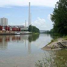
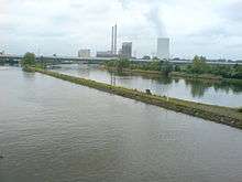
One example is the densely populated and industrialised Neckar valley between Plochingen and Bad Cannstatt, which harbors large companies such as Daimler AG (the maker of Mercedes Benz cars) and Mahle GmbH and recreational facilities with large area consumption like the Mercedes-Benz Arena, the Hanns-Martin-Schleyer-Halle or the Cannstatter Wasen, the second largest fair of Germany. The term Wasen gives a clue, that there used to be a floodplain on which the fair was held. Distinctive points in the industrial landscape of the Neckar valley are the high chimneys of the coal-fired power station Altbach/Deizisau and Heilbronn as well as the assembly halls of the Daimler-engine plant in Untertürkheim and the Audi plant in Neckarsulm.
Along the Neckar's valley in the Odenwald hills many castles can be found, including Hornberg Castle and Guttenberg Castle in Haßmersheim; the now-mothballed Obrigheim Nuclear Power Plant and the active Neckarwestheim Nuclear Power Plant are also located there.
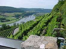
In contrast to the plains, the mostly steep slopes are often forested and in forestry use. The sun exposed south facing sites are frequently used for vineyards and are terraced with dry walls. There the local red wine grapes Trollinger, Schwarzriesling and Lemberger are cultivated, which are also traditionally mostly drunk in Württemberg. Especially the middle Neckar around Besigheim and Lauffen is characterized by in parts extremely steep vineyards, which can be cultivated only by hand.
The vine terrasses at the Neckar together with the drainage area of the tributaries deliver the largest part of the cultivation area of the Württemberg wine region. The vineyards at the lower reaches from Heinsheim to Heidelberg are part of the Baden wine region. Until the end of the 19th century vineyard cultivation was more extensive in the Neckar valley including unfavorable sites. Still today have been abandoned and gone fallow, reclaimed by wildlife. One example are the southern slopes of the Spitzberg above the Neckar near Tübingen.
The river's course provides a popular route for cyclists, especially during the summer months. The slopes of the Neckar are preferred areas for high-level residential areas because they allow wide, unobstructed views.
Renaturation

The diverse usage of raw water and waterway, as well for the production of hydropower brought with it substantial interventions into the ecological structure of the river. Multiple initiatives are advocate for the land restoration the Neckar, the ecological enhancement of the river network, the improvement of the water quality, improved flood control and the creation of attractive local recreational areas alongside the river. Only recently within the frame of the nationwide campaign lively rivers and the initiative Lebendiger Neckar (German: lively Neckar), it was begun to free it from ist partly existing concrete corsett. The river has in parts beenredeveloped as a local recreational area and habitat for animals and plants. It still remains a symbol of endangered nature with the highest power plant density in Germany. At an oxygen content of below 4 mg/l power plant owners have to run specially designed turbines to inject air into the water. As of 2003, no mass die-off of fish due to lack of oxygen had occurred for 20 years.[4]
Climate
The Neckar valley functions as a cold air basin, which means that under cloudless skies the heavier, cold night ir, which develops on the sparsely vegetated plateaus and hills, flows into the basin and concentrates there. Especially during the cold season, such “cold lakes” can contribute to the creation of fog while all around on the plateaus the sun shines. The Orography of the Neckar valley facilitates such inversive weather conditions.
The Neckar valley is known for its wine cultivation climate and the cultivation of Trollinger, Lemberger, Kerner, Müller-Thurgau amongst other locally grown grape varieties. Wine cultivation has receded over the 20th century and cultivation of the “Württemberger Wein“ is mostly restricted to the southfacing slopes with high radiation gain in the Neckar valley and its side valleys, as wine cultivation is labor-intensive and in Württemberg competitive only in the best sites.
Water transport and bridges
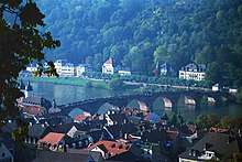
Famous bridges include the Neckar Valley Bridge Weitingen, near the town Horb am Neckar and the Old Bridge, in Heidelberg.
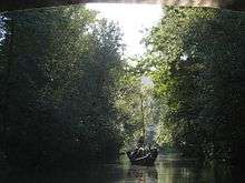
Numerous excavations of ports and finds allow the conclusion that, especially on the lower Neckar, the Neckar water transport already existed at Roman times since the middle of the first century, mostly likely for the transportation of construction material for the Limes and for provisions. Later the Franks probably restarted the Neckar navigation.
From about 1100 Black Forest timber was rafted downstream as far as Holland, for use in shipyards.
During the 19th century, traditional horse-drawn boats were replaced by steam-powered chain boats that used a 155 km (96 mi) long chain in the river to haul themselves upstream towing barges. In 1899 a railway enabled transport of timber to the port of Heilbronn, limiting timber rafting to the lower part of the Neckar.
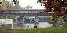
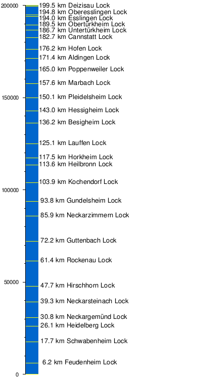
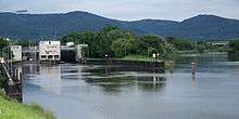
After 1935, ships up to 1500 t could travel to Heilbronn due to the construction of 11 locks. By 1968 the last of 27 locks, at Deizisau, was completed, making the Neckar navigable for cargo ships about 200 kilometres (120 mi) upstream from Mannheim to the river port of Plochingen, at the confluence with the Fils, and where the Neckar bends, taking a northwesterly instead of a northeasterly course. Other important ports include Stuttgart and Heilbronn.
The world's first motorboat made during the summer of 1886 by Gottlieb Daimler and Wilhelm Maybach was named "Neckar" when their Standuhr (grandfather clock) petrol engine was tested on the river near Bad Cannstatt.
In the arts
- Friedrich Hölderlin wrote a poem entitled "Der Neckar".[5]
- Mark Twain mentioned the Neckar in A Tramp Abroad.[6]
- The Neckar is mentioned prominently in Gustav Mahler's 1893 "Rheinlegendchen" ('Little Rhine Legend'), first published in 1899 in a cycle of 12 songs under the title Humoresken ('Humoresques'), today known as one of Mahler's Songs from Des Knaben Wunderhorn (Songs from The Youth's Magic Horn).[7]
References
- Map services of the Baden-Württemberg State Office for the Environment, Survey and Conservation (Landesanstalt für Umwelt, Messungen und Naturschutz Baden-Württemberg)
- "Abteilung 2: Geologie und Bodenkunde" (PDF). Landesamt für Geologie, Rohstoffe und Bergbau. Archived from the original (PDF) on 2004-07-30. Retrieved 2017-03-20. Abbildung 22
- M. Eisenlohr. "Die Flußkorrektion bei Mannheim und deren Einwirkung auf die Entwicklung der Stadt" (PDF 15 MB). pp. 15 und Tafel 7. Retrieved 2015-05-04.
- Gütezustand der Fließgewässer im Neckar-Einzugsgebiet (PDF), IKoNE 5 (in German), p. 18, archived from [Archived [Date missing] at ikone-online.de [Error: unknown archive URL] the original] Check
|url=value (help) on 2012-02-01, retrieved 2017-03-20 - Zeno (n.d.). "Literatur im Volltext: Friedrich Hölderlin: Sämtliche Werke. 6 Bände, Band 2, Stuttgart 1953". www.zeno.org (in German). Retrieved 2019-12-16.
- Mark Twain. "A Tramp Abroad - Chapter XIV - Rafting Down the Neckar". americanliterature.com. Retrieved 2019-12-16.
- Parsons, James; Cross, Jonathan (July 2004). The Cambridge Companion to the Lied. Cambridge University Press. ISBN 978-0-521-80471-4.
External links
| Wikimedia Commons has media related to Neckar. |
Tributaries of the Rhine | ||
|---|---|---|
| Left (western) |
|  |
| Right (eastern) |
| |