Main (river)
The Main (German pronunciation: [ˈmaɪn] (![]()
| Main | |
|---|---|
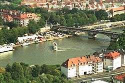 The Main River in Würzburg | |
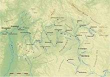 Position of the Main in Germany | |
| Location | |
| Country | Germany |
| Physical characteristics | |
| Source | |
| ⁃ location | Upper Franconia |
| ⁃ coordinates | 50°5′11″N 11°23′54″E |
| Mouth | |
⁃ location | Rhine |
⁃ coordinates | 49°59′40″N 8°17′36″E |
| Length | 524.9 km (326.2 mi) [1] |
| Basin size | 27,208 km2 (10,505 sq mi) [1] |
| Discharge | |
| ⁃ average | 200 m3/s (7,100 cu ft/s) |
| Basin features | |
| Progression | Rhine→ North Sea |
Geography
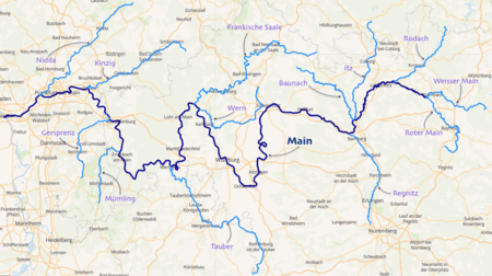
The mainspring of the Main River flows through the German states of Bavaria, Baden-Württemberg (forming the border with Bavaria for some distance) and Hesse. Its basin competes with the Danube for water; as a result, many of its boundaries are identical with those of the European Watershed.
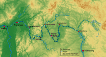
The Main begins near Kulmbach in Franconia at the joining of its two headstreams, the Red Main (Roter Main) and the White Main (Weißer Main). The Red Main originates in the Franconian Jura mountain range, 50 km (31 mi) in length, and runs through Creussen and Bayreuth. The White Main originates in the mountains of the Fichtelgebirge; it is 41 km (25 mi) long. In its upper and middle section, the Main runs through the valleys of the German Highlands. Its lower section crosses the Lower Main Lowlands (Hanau-Seligenstadt Basin and northern Upper Rhine Plain) to Wiesbaden, where it discharges into the Rhine. Major tributaries of the Main are the Regnitz, the Franconian Saale, the Tauber, and the Nidda.
The name "Main" derives from the Latin Moenus or Menus. It is not related to the name of the city Mainz (Latin: Moguntiacum).
Navigation
The Main is navigable for shipping from its mouth at the Rhine close to Mainz for 396 km (246 mi) to Bamberg. Since 1992, the Main has been connected to the Danube via the Rhine-Main-Danube Canal and the highly regulated Altmühl river. The Main has been canalized with 34 large locks (300 × 12 m or 984 × 39 ft) to allow CEMT class V vessels (110 × 11.45 m or 360.9 × 37.6 ft) to navigate the total length of the river. The 16 locks in the adjacent Rhine-Main-Danube Canal and the Danube itself are of the same dimensions.
Dams and locks
There are 34 dams and locks along the 380 km navigable portion of the Main, from the confluence with the Regnitz near Bamberg, to the Rhine.[2]
- No.: Number of the lock (from upstream to downstream).
- Name: Name of the lock.
- Location: City or town where the lock is located.
- Year built: Year when the lock was put into operation (replacement dates are also listed where applicable).
- Main-km: Location on the Main, measured from the 0 km stone in Mainz-Kostheim. The reference point is the center of the lock or lock group.
- Distance between locks : length in km of impoundment (between adjacent locks).
- Altitude: height in meters above mean sea level of the upper water at normal levels.
- Height: Height of the dam in meters (the height of the Kostheim lock depends on the water level of the Rhine).
- Lock length: Usable length of the lock chamber in meters.
- Lock width: Usable width of the lock chamber in meters.
| No. | Name | Location | Year built | Main-km | Distance between locks (km) | Altitude (m) | Height (m) | Lock length (m) | Lock width (m) |
|---|---|---|---|---|---|---|---|---|---|
| 1 | Viereth | Viereth-Trunstadt | 1925 | 380.699 | 230.86 | 6.00 | 289.80 | 12.00 | |
| 2 | Limbach | Eltmann | 1951 | 367.176 | 13.523 | 224.86 | 5.36 | 299.10 | 12.00 |
| 3 | Knetzgau | Knetzgau (Haßfurt) | 1958 | 359.781 | 7.395 | 219.50 | 4.24 | 298.85 | 12.00 |
| 4 | Ottendorf | Gädheim | 1962 | 345.263 | 14.518 | 215.26 | 7.59 | 301.60 | 12.00 |
| 5 | Schweinfurt | Schweinfurt | 1963 | 332.037 | 13.226 | 207.67 | 4.67 | 300.60 | 12.00 |
| 6 | Garstadt | Bergrheinfeld | 1956 | 323.503 | 8.534 | 203.00 | 4.69 | 299.75 | 12.00 |
| 7 | Wipfeld | Wipfeld | 1950 | 316.289 | 7.214 | 198.31 | 4.31 | 300.15 | 12.00 |
| 8 | Gerlachshausen mit Volkach | Volkach (Schwarzach am Main) | 1957 | 300.506 | 15.783 | 194.00 | 6.30 | 300.00 | 12.00 |
| 9 | Dettelbach | Dettelbach | 1959 | 295.398 | 5.108 | 187.70 | 5.50 | 299.35 | 12.00 |
| 10 | Kitzingen | Kitzingen | 1956 | 283.979 | 11.419 | 182.20 | 3.66 | 299.80 | 12.00 |
| 11 | Marktbreit | Marktbreit (Frickenhausen am Main) | 1955 | 275.681 | 8.298 | 178.54 | 3.31 | 296.40 | 12.00 |
| 12 | Goßmannsdorf | Ochsenfurt | 1952 | 269.028 | 6.653 | 175.23 | 3.40 | 296.90 | 12.00 |
| 13 | Randersacker | Würzburg (Randersacker) | 1950 | 258.885 | 10.143 | 171.83 | 3.30 | 299.60 | 12.00 |
| 14 | Würzburg | Würzburg | 1954 | 252.512 | 6.373 | 168.53 | 2.75 | 293.10 | 12.00 |
| 15 | Erlabrunn | Erlabrunn (Thüngersheim) | 1935 | 241.204 | 11.308 | 165.78 | 4.15 | 299.20 | 12.00 |
| 16 | Himmelstadt | Himmelstadt | 1939 | 232.290 | 8.914 | 161.63 | 4.30 | 299.50 | 12.00 |
| 17 | Harrbach | Karlstadt (Gemünden am Main) | 1939 | 219.466 | 12.824 | 157.33 | 4.90 | 299.45 | 12.00 |
| 18 | Steinbach | Lohr am Main | 1939 | 200.673 | 18.793 | 152.43 | 5.14 | 299.10 | 12.00 |
| 19 | Rothenfels | Rothenfels (Marktheidenfeld) | 1937 | 185.887 | 14.786 | 147.29 | 5.26 | 298.45 | 12.00 |
| 20 | Lengfurt | Triefenstein | 1937 | 174.508 | 11.379 | 142.03 | 3.99 | 300.08 | 11.98 |
| 21 | Eichel | Wertheim | 1937 | 160.467 | 14.041 | 138.04 | 4.50 | 299.92 | 12.00 |
| 22 | Faulbach | Wertheim (Faulbach) | 1935 | 147.065 | 13.402 | 133.54 | 4.51 | 299.80 | 12.10 |
| 23 | Freudenberg | Collenberg (Freudenberg) | 1934 | 133.948 | 13.117 | 129.03 | 4.51 | 300.00 | 12.00 |
| 24 | Heubach | Großheubach (Miltenberg) | 1932 | 122.360 | 11.588 | 124.52 | 4.00 | 300.00 | 12.00 |
| 25 | Klingenberg | Klingenberg am Main | 1930 | 113.050 | 9.310 | 120.52 | 4.00 | 300.71 | 12.05 |
| 26 | Wallstadt | Kleinwallstadt (Großwallstadt) | 1930 | 101.203 | 11.847 | 116.52 | 4.00 | 299.93 | 12.00 |
| 27 | Obernau | Niedernberg (Aschaffenburg) | 1930 | 92.909 | 8.294 | 112.52 | 4.01 | 299.18 | 12.00 |
| 28 | Kleinostheim | Kleinostheim (Stockstadt am Main) | 1920 1972 | 77.905 | 15.004 | 108.51 | 6.80 | 298.36 298.22 | 12.04 12.02 |
| 29 | Krotzenburg | Hainburg (Großkrotzenburg) | 1920 1983 | 63.850 | 14.055 | 101.71 | 2.74 | 302.30 300.01 | 12.00 12.00 |
| 30 | Mühlheim (formerly Kesselstadt) | Maintal (Mühlheim am Main) | 1920 1980 | 53.185 | 10.385 | 98.97 | 3.77 | 299.90 | 12.04 |
| 31 | Offenbach | Frankfurt am Main (Offenbach am Main) | 1901 1957 | 38.514 | 14.671 | 95.20 | 3.18 | 344.03 230.07 | 12.09 13.05 |
| 32 | Griesheim | Frankfurt am Main | 1934 | 28.687 | 9.827 | 92.02 | 4.49 | 344.05 344.38 | 12.00 15.00 |
| 33 | Eddersheim | Hattersheim am Main (Kelsterbach) | 1934 | 15.551 | 13.136 | 87.53 | 3.61 | 345.46 344.26 | 12.05 15.05 |
| 34 | Kostheim | Hochheim am Main (Ginsheim-Gustavsburg) | 1886 1934 | 3.209 | 12.342 | 83.92 | 2.36 (MW Rhine) | 341.90 339.02 | 15.00 Door: 12.00 Chamber: 20.00 |
Hydroelectric power generation
Most of the dams along the Main also have turbines for power generation.
- No.: Number of the dam (from upstream to downstream).
- Name: Name of the dam.
- Height: Height of the dam in meters (the height of the Kostheim dam depends on the water level of the Rhine).
- Power: Maximum power generation capacity in megawatts.
- Turbines: Type and number of turbines.
- Operator: Operator of the hydroelectric plant.
| No. | Name | Height (m) | Power (MW) | Turbines | Operator |
|---|---|---|---|---|---|
| 1 | Viereth | 6.00 | 6.20 | Francis(3), Kaplan(1) | E.ON Wasserkraft |
| 2 | Limbach | 5.36 | 3.70 | Kaplan(2) | E.ON Wasserkraft |
| 3 | Knetzgau | 4.24 | 2.90 | Kaplan(2) | E.ON Wasserkraft |
| 4 | Ottendorf | 7.59 | 6.30 | Kaplan(2) | E.ON Wasserkraft |
| 5 | Schweinfurt | 4.67 | 3.80 | Kaplan(2) | E.ON Wasserkraft |
| 6 | Garstadt | 4.69 | 3.90 | Kaplan(2) | E.ON Wasserkraft |
| 7 | Wipfeld | 4.31 | 2.90 | Kaplan(2) | E.ON Wasserkraft |
| 8 | Gerlachshausen mit Volkach | 6.30 | 3.90 | Kaplan(2) | E.ON Wasserkraft |
| 9 | Dettelbach | 5.50 | 4.20 | Kaplan(2) | E.ON Wasserkraft |
| 10 | Kitzingen | 3.66 | 3.00 | Kaplan(2) | E.ON Wasserkraft |
| 11 | Marktbreit | 3.31 | 2.10 | Kaplan(2) | E.ON Wasserkraft |
| 12 | Goßmannsdorf | 3.40 | 2.00 | Kaplan(2) | E.ON Wasserkraft |
| 13 | Randersacker | 3.30 | 2.00 | Kaplan(2) | E.ON Wasserkraft |
| 14 | Würzburg | 2.75 | 0.90 | Kaplan(3) | E.ON Wasserkraft |
| 15 | Erlabrunn | 4.15 | 2.70 | Kaplan(1) | E.ON Wasserkraft |
| 16 | Himmelstadt | 4.30 | 2.50 | Kaplan(1) | E.ON Wasserkraft |
| 17 | Harrbach | 4.90 | 3.00 | Kaplan(2) | E.ON Wasserkraft |
| 18 | Steinbach | 5.14 | 4.20 | Kaplan(2) | E.ON Wasserkraft |
| 19 | Rothenfels | 5.26 | 4.20 | Kaplan(2) | E.ON Wasserkraft |
| 20 | Lengfurt | 3.99 | 2.60 | E.ON Wasserkraft | |
| 21 | Eichel | 4.50 | 3.10 | E.ON Wasserkraft | |
| 22 | Faulbach | 4.51 | 4.10 | E.ON Wasserkraft | |
| 23 | Freudenberg | 4.51 | 4.30 | E.ON Wasserkraft | |
| 24 | Heubach | 4.00 | 3.40 | E.ON Wasserkraft | |
| 25 | Klingenberg | 4.00 | 3.00 | E.ON Wasserkraft | |
| 26 | Wallstadt | 4.00 | 3.40 | E.ON Wasserkraft | |
| 27 | Obernau | 4.01 | 3.20 | E.ON Wasserkraft | |
| 28 | Kleinostheim | 6.80 | 9.70 | E.ON Wasserkraft | |
| 29 | Krotzenburg | 2.74 | — | ||
| 30 | Mühlheim | 3.77 | 4.80 | E.ON Wasserkraft | |
| 31 | Offenbach | 3.18 | 4.10 | E.ON Wasserkraft | |
| 32 | Griesheim | 4.49 | 4.90 | Kaplan(3) | Wasser- und Schifffahrtsamt Aschaffenburg |
| 33 | Eddersheim | 3.61 | 3.84 | Kaplan(3) | Wasser- und Schifffahrtsamt Aschaffenburg |
| 34 | Kostheim | 2.36 | 4.9 | Kaplan Pit-Rohrturbinen(2) | WKW Staustufe Kostheim/Main GmbH & Co. KG (Gebaut und Betrieben von Stadtwerke Ulm/Neu-Ulm) |
Tributaries
Tributaries from source to mouth:
|
Left
|
Right
|
 The Main in Frankfurt at night
 Main in Offenbach am Main
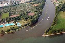 Confluence into the Rhine at Mainz-Kostheim
Ports and municipalities
Around Frankfurt are several large inland ports. Because the river is rather narrow on many of the upper reaches, navigation with larger vessels and push convoys requires great skill.
The largest cities along the Main are Frankfurt am Main, Offenbach am Main and Würzburg. The Main also passes the following towns: Burgkunstadt, Lichtenfels, Bad Staffelstein, Eltmann, Haßfurt, Schweinfurt, Volkach, Kitzingen, Marktbreit, Ochsenfurt, Karlstadt, Gemünden, Lohr, Marktheidenfeld, Wertheim, Miltenberg, Obernburg, Erlenbach/Main, Aschaffenburg, Seligenstadt, Hainburg, Hanau, Hattersheim, Flörsheim, and Rüsselsheim.
The river has gained enormous importance as a vital part of European "Corridor VII", the inland waterway link from the North Sea to the Black Sea.[3]
Main line
In a historical and political sense, the Main line is referred to as the northern border of Southern Germany, with its predominantly Catholic population. The river roughly marked the southern border of the North German Federation, established in 1867 under Prussian leadership as the predecessor of the German Empire.
The river course also corresponds with the Speyer line isogloss between Central and Upper German dialects, sometimes mocked as Weißwurstäquator.
Recreation
The Main-Radweg is a major German bicycle path running along the Main River. It is approximately 600 kilometres long (370 mi) and was the first long-distance bicycle path to be awarded 5 stars by the General German Bicycle Club ADFC in 2008. It starts from either Creußen or Bischofsgrün and ends in Mainz.[4]
Sights
- Roman camp at Marktbreit
References
- Complete table of the Bavarian Waterbody Register by the Bavarian State Office for the Environment (xls, 10.3 MB)
- "Daten und Fakten" [Facts and figures] (in German). Wasser- und Schifffahrtsdirektion Süd. June 2003. Archived from the original on 13 June 2013. Retrieved 7 June 2009.
- "NoorderSoft Waterways Database". Retrieved 2007-10-24.
- "Main-Radweg". Archived from the original on 7 November 2019. Retrieved 23 April 2013.
Bibliography
- Haus der Bayerischen Geschichte (ed.), Main und Meer - Porträt eines Flusses. Exhibition Catalogue to the Bayerische Landesausstellung 2013 (German). WBG. ISBN 978-3-534-00010-4.
External links
| Wikimedia Commons has media related to Main (river). |
| Look up main (river) in Wiktionary, the free dictionary. |
| Wikisource has the text of a 1911 Encyclopædia Britannica article about the River Main. |
- Main River Website on the River Main by the Tourist Board of Franconia. (in English)

- There is literature about Main (river) in the Hessian Bibliography
- Water levels of Bavarian rivers
- Wasser- und Schifffahrtsdirektion Süd
- Main Cycleway
- Historical map of the Main confluence at Steinenhausen from BayernAtlas
Tributaries of the Rhine | ||
|---|---|---|
| Left (western) |
|  |
| Right (eastern) |
| |
| Authority control |
|
|---|