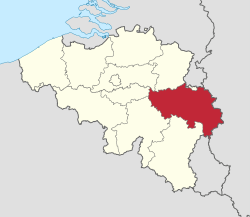
Liège Province
Liège (French: [ljɛʒ] (![]()
![]()
Province of Belgium | |
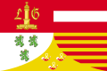 Flag .svg.png) Coat of arms | |
 | |
| Coordinates: 50°38′N 05°34′E | |
| Country | |
| Region | |
| Capital (and largest city) | Liège |
| Government | |
| • Governor | Hervé Jamar |
| Area | |
| • Total | 3,857 km2 (1,489 sq mi) |
| Population (1 January 2019)[2] | |
| • Total | 1,106,992 |
| • Density | 288/km2 (750/sq mi) |
| HDI (2017) | 0.884[3] very high · 10th |
| Website | Official site |
It borders (clockwise from the north) the Dutch province of Limburg, the German states of North Rhine-Westphalia and Rhineland-Palatinate, Diekirch in Luxembourg, and the Walloon provinces Luxembourg, Namur and Walloon Brabant, as well as the Flemish provinces of Flemish Brabant and Limburg.
The province is divided into a Walloon (French-speaking) part and a Belgo-German area.
The capital and the largest city of the province is the city of the same name, Liège. The province has an area of 3,857 km2 (1,489 sq mi), and a population of 1,106,992 as of January 2019.[4]
History
The modern borders of the province of Liège date from 1795, which saw the unification of the Principality of the Prince-Bishopric of Liège with the revolutionary French Department of the Ourthe (sometimes spelled Ourte). (Parts of the old Principality of Liege also went into new French départements Meuse-Inférieure, and Sambre-et-Meuse.)
The province of Ourthe, as it was known then, was under French control during the reign of Napoleon Bonaparte. Napoleon visited the city during one of his campaigns and ordered the destruction of its vineyards in order to prevent the Liege wine industry from competing with its French counterpart.
Following Napoleon's fall from power in 1815, Liege became part of the Kingdom of the Netherlands, while eastern half of modern Verviers became part of the Kingdom of Prussia. Liege University scholars helped to write the new Dutch constitution after the Napoleonic Wars. Despite these contributions there was a widespread perception among the people of Liege that they were discriminated against by the Dutch government due to religious and language differences.
In September 1830, rumors spread that Walloons in Brussels were expelling the Dutch. Liege intellectuals responded to these events by contacting Walloon scholars living in Paris to discuss Belgian independence. A militia was formed to press these demands led by Charlier "Wooden Leg" leading (eventually) to the formation of an independent Kingdom of Belgium.
In the 19th Century, the province was an early center of the Industrial Revolution. Its rich coal deposits and steel factories helped Belgium to form the basis of the region's increasing economic power.
During the 20th century, due to Liège's borders with Germany, it saw fierce fighting in both World Wars. In World War I, Liege's strong line of reinforced concrete military forts temporarily halted the German advance through Belgium, giving time to construct trenches in Flanders which subsequently saw some of the worst fighting of that war. In world War II, Liège was the site of major fighting during the Battle of the Bulge. There, the Germans orchestrated their final offensive move against the combined Allied armies. Malmedy and Saint-Vith in particular saw intense battles against the Nazis.
Liège's heavy industry thrived in the 1950s and 1960sbut this has been in steady decline since that time. Liege is the last city of Wallonia that still maintains a functioning steel industry.
Liège continues to be the economic and cultural capital of Wallonia, with its university, medieval heritage and heavy industry.
Economy
The Gross domestic product (GDP) of the province was 31.6 billion € in 2018, accounting for 6.9% of Belgiums economic output. GDP per capita adjusted for purchasing power was 25,200 € or 84% of the EU27 average in the same year. GDP per person employed was 108% of the EU27 average.[5]
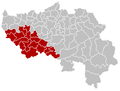
Subdivisions
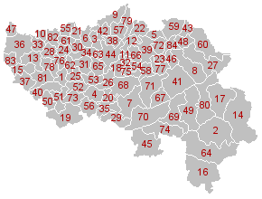
The province has an area of 3,857 square kilometres (1,489 sq mi), which is divided into four administrative districts (arrondissements in French) containing a total of 84 municipalities.
Arrondissements
The Province of Liège is divided into four administrative arrondissements:
 Huy
Huy Liège
Liège Verviers
 Waremme
Municipalities
Municipalities that have city status have a (city) behind their name.
- Amay
- Amel
- Ans
- Anthisnes
- Aubel
- Awans
- Aywaille
- Baelen
- Bassenge
- Berloz
- Beyne-Heusay
- Blegny
- Braives
- Büllingen
- Burdinne
- Burg-Reuland
- Bütgenbach
- Chaudfontaine
- Clavier
- Comblain-au-Pont
- Crisnée
- Dalhem
- Dison
- Donceel
- Engis
- Esneux
- Eupen (city)
- Faimes
- Ferrières
- Fexhe-le-Haut-Clocher
- Flémalle
- Fléron
- Geer
- Grâce-Hollogne
- Hamoir
- Hannut (city)
- Héron
- Herstal
- Herve (city)
- Huy (city)
- Jalhay
- Juprelle
- Kelmis
- Liège (city)
- Lierneux
- Limbourg (city)
- Lincent
- Lontzen
- Malmedy (city)
- Marchin
- Modave
- Nandrin
- Neupré
- Olne
- Oreye
- Ouffet
- Oupeye
- Pepinster
- Plombières
- Raeren
- Remicourt
- Saint-Georges-sur-Meuse
- Saint-Nicolas
- Sankt Vith (city)
- Seraing (city)
- Soumagne
- Spa (city)
- Sprimont
- Stavelot (city)
- Stoumont
- Theux
- Thimister-Clermont
- Tinlot
- Trois-Ponts
- Trooz
- Verlaine
- Verviers (city)
- Villers-le-Bouillet
- Visé (city)
- Waimes
- Wanze
- Waremme (city)
- Wasseiges
- Welkenraedt
Nine municipalities of Liège form the German-speaking Community of Belgium. From north to south they are: Kelmis (43), Lontzen (48), Raeren (60), Eupen (27), Bütgenbach (17), Büllingen (14), Amel (2), Sankt Vith (64), and Burg-Reuland (16) municipalities. Malmedy (49) and Waimes (80) are municipalities with language facilities for German speakers. The other municipalities of Liège are part of the French Community of Belgium.
List of Governors
- 1830–1831: Etienne de Sauvage (Liberal)
- 1831–1832: Jean-François Tielemans (Liberal)
- 1832–1844: Charles van den Steen de Jehay
- 1844–1846: Henri de Brouckère (Liberal)
- 1846–1847: Edmond de la Coste (Liberal)
- 1847–1863: Ferdinand de Macar (Liberal)
- 1863–1882: Charles de Luesemans (Liberal)
- 1882–1908: Léon Pety de Thozée
- 1908–1919: Henry Delvaux de Fenffe (Catholic Party)
- 1919–1927: Gaston Gregoire (Liberal)
- 1927–1937: Henri Pirard
- 1937–1943: Jules Mathieu
- 1944–1953: Joseph Leclercq (PSB)
- 1953–1971: Pierre Clerdent (PRL)
- 1972–1990: Gilbert Mottard (PS)
- 1990–2004: Paul Bolland
- 2004–2015: Michel Foret (MR)
- 2015–present Hervé Jamar (MR)
References
- https://bestat.statbel.fgov.be/bestat/crosstable.xhtml?view=90c1e218-dc4f-4827-824d-9b25abfefe59
- https://statbel.fgov.be/nl/themas/bevolking/structuur-van-de-bevolking
- "Sub-national HDI - Area Database - Global Data Lab". hdi.globaldatalab.org. Retrieved 2018-09-13.
- https://statbel.fgov.be/nl/themas/bevolking/structuur-van-de-bevolking
- "Regional GDP per capita ranged from 30% to 263% of the EU average in 2018". Eurostat.
External links
| Wikimedia Commons has media related to Liège (province). |
- Official web site of the Liège province (in French and German)
- Bureau des Relations Extérieures de la Province de Liège (in French)
| Communities |
|  | |||||
|---|---|---|---|---|---|---|---|
| Regions and Provinces |
| ||||||
| Arrondissements |
| ||||||
| Municipalities by region |
| ||||||