Rhineland-Palatinate
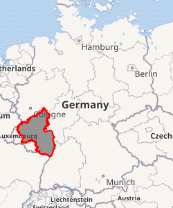
Rhineland-Palatinate (German: Rheinland-Pfalz, pronounced [ˈʁaɪ̯nlant ˈp͡falt͡s]) is a state of Germany located in the west of the country. Covering an area of 19,846 km2 (7,663 sq mi) and with a population of 4.05 million inhabitants, it is the seventh-most populous German state. Mainz is the state capital and largest city, while other major cities include Ludwigshafen am Rhein, Koblenz, Trier, Kaiserslautern and Worms.[3] Rhineland-Palatinate is surrounded by the states of North Rhine-Westphalia, Saarland, Baden-Württemberg and Hesse. It also borders three foreign countries: France, Luxembourg and Belgium.
Rhineland-Palatinate Rheinland-Pfalz | |
|---|---|
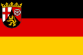 Flag  Coat of arms | |
| |
| Coordinates: 49°54′47″N 7°27′0″E | |
| Country | Germany |
| Capital | Mainz |
| Government | |
| • Body | Landtag of Rhineland-Palatinate |
| • Minister-President | Malu Dreyer (SPD) |
| • Governing parties | SPD / FDP / Greens |
| • Bundesrat votes | 4 (of 69) |
| Area | |
| • Total | 19,854.21 km2 (7,665.75 sq mi) |
| Time zone | UTC+1 (CET) |
| • Summer (DST) | UTC+2 (CEST) |
| ISO 3166 code | DE-RP |
| GDP (nominal) | €124 billion (2013)[1] |
| GDP per capita | €31,100 (2013) |
| NUTS Region | DEB |
| HDI (2017) | 0.927[2] very high · 10th of 16 |
| Website | www |
Rhineland-Palatinate was established in 1946 after World War II, from territory of the historically separate regions of the Free State of Prussia, the People's State of Hesse and Bavaria, by the French military administration in Allied-occupied Germany. Rhineland-Palatinate became part of the Federal Republic of Germany in 1949 and shared the country's only border with the Saar Protectorate until it was returned to German control in 1957. Rhineland-Palatinate has since developed its own identity built on its natural and cultural heritage, including the extensive Palatinate winegrowing region, its picturesque landscapes, and its many castles and palaces.[4]
History


The state of Rhineland-Palatinate was founded shortly after the Second World War, on 30 August 1946. It was formed mainly from the southern part of the Prussian Rhine Province (the Regierungsbezirke of Koblenz and Trier), from Rhenish Hesse, from the western part of Nassau and the Bavarian Rhenish Palatinate minus the county of Saarpfalz. The Joint German-Luxembourg Sovereign Region (Gemeinschaftliches deutsch-luxemburgisches Hoheitsgebiet) is the only unincorporated area of the state of Rhineland-Palatinate. This condominium is formed by the rivers Moselle, Sauer, and Our, where they run along the border between Luxembourg and Rhineland-Palatinate or the Saarland.[3]
Emergence
The present state of Rhineland-Palatinate formed part of the French Zone of Occupation (1945-1949) after the Second World War. It comprised the former Bavarian Palatinate, the Regierungsbezirke ("government districts") of Koblenz and Trier of the old Prussian Rhine Province, those parts of the Province of Rhenish Hesse (Rheinhessen) west of the River Rhine and belonging to the People's State of Hesse (Volksstaat Hessen), parts of the Prussian province of Hesse-Nassau (Montabaur), and the former Oldenburg region around Birkenfeld (Principality of Birkenfeld).
On 10 July 1945, the occupation authority on the soil of the present-day Rhineland-Palatinate transferred from the Americans to the French. To begin with, the French divided the region provisionally into two "upper presidiums" (Oberpräsidien), Rhineland-Hesse-Nassau (for the hitherto Prussian government districts and regions of Koblenz, Trier, and Montabaur) and Hesse-Palatinate (for the hitherto Bavarian Palatinate and old Hessian-Darmstadt province of Rhenish Hesse). The formation of the state was ordained on 30 August 1946, the last state in the Western Zone of Occupation to be established, by Regulation No. 57 of the French military government under General Marie-Pierre Kœnig.[5] It was initially called Rhenish-Palatinate (Rheinpfälzisches Land or Land Rheinpfalz); the name Rhineland-Palatinate (Rheinland-Pfalz) was first confirmed in the constitution of 18 May 1947.[6]
The provisional French government at that time wanted originally to leave the option open of annexing further areas west of the Rhine after the Saarland was turned into a protectorate. When the Americans and British, however, had led the way with the establishment of German federal states, the French came under increasing pressure and eventually followed their example by setting up the states of Baden, Württemberg-Hohenzollern, and Rhineland-Palatinate. However, the French military government forbade the Saarland joining Rhineland-Palatinate. Mainz was named as the state capital in the regulation; the "Mixed Commission" (Gemischte Kommission), named as the highest organ of state charged with the administration of the new state and with the preparation of an advisory state assembly, started its work in Mainz. However, war damage and destruction meant that Mainz did not have enough administrative buildings, so the headquarters of the state government and parliament was provisionally established in Koblenz. On 22 November 1946, the constituent meeting of the Advisory State Assembly (Beratende Landesversammlung) took place there, and a draft constitution was drawn up. Previously, local elections had been held. Wilhelm Boden was (after a short term of office as the Oberregierungspräsident of Rhineland-Hesse-Nassau) nominated on 2 December as the minister president of the new state by the French military government.
Early years
Adolf Süsterhenn submitted to the Advisory State Assembly a draft constitution, which was passed after several rounds of negotiation on 25 April 1947 in a final vote, with the absolute majority of the CDU voting for and the SPD and KPD voting against. A point of contention involved the draft constitution providing for separate schools based on Christian denomination. On 18 May 1947 53% of the electorate adopted the Constitution for Rhineland-Palatinate in a referendum. While the Catholic north and west of the new state adopted the constitution by a majority, the majority in Rhenish Hesse and the Palatinate voted against. On the same date the first elections took place for the state parliament, the Landtag of Rhineland-Palatinate. The inaugural assembly of parliament took place on 4 June 1947 in the large city hall at Koblenz. Wilhelm Boden was elected the first minister-president of Rhineland-Palatinate. Just one month later, Peter Altmeier succeeded him.
The constitutional bodies -the Government (Landesregierung), the Parliament (Landtag) and the Constitutional Court (Verfassungsgerichtshof) - established their provisional seat in Koblenz. In the following period, Koblenz and Mainz each emphasized their suitability as the state capital in a public debate. From the beginning, Minister-President Altmeier pressed for Mainz as the capital because he knew that the south of the country, especially the Palatinate, would not accept Koblenz, which was far to the north and formerly Prussian. On 16 May 1950, the Landtag decided to relocate itself and the Landesregierung from Koblenz to Mainz.[7][8] After the government and parliament moved to Mainz, many state authorities and courts remained in Koblenz, including the Constitutional Court and the State Archives. In addition, the German Federal Archives and Federal Office of Hydrology were established in Koblenz in 1952.
Consolidation
A sense of community developed only very gradually in the "land of the retort", which had been established largely without regard to the historical affiliations of its inhabitants. It was given little chance of survival, especially as it had very few large industrial centres. However, the establishment of numerous military bases, both Allied and Bundeswehr, helped to some extent to boost the economy. In 1956, under Article 29 of the Basic Law for the Federal Republic of Germany, petitions were made in the regions of Koblenz, Trier, Montabaur, Rhenish Hesse, and Palatinate for their incorporation into the respective states of North Rhine-Westphalia, Hesse, Bavaria, and Baden-Württemberg. All petitions for a referendum except those in the administrative district of Palatinate won the necessary majority; however, almost 20 years passed before the referenda finally took place. On 19 January 1975, none of the regions concerned returned a majority for being transferred to another state. This put an end to decades of discussion. Only the AKK conflict, a dispute over the districts of Mainz-Amöneburg, Mainz-Kastel, and Mainz-Kostheim, has continued to exercise politicians up to the present day.
Geography
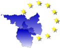
Rhineland-Palatinate shares international borders with France (Grand Est), Luxembourg (Clervaux, Diekirch, Echternach, Grevenmacher, Remich, and Vianden), and Belgium (Wallonia). Within Germany, it neighbours are Baden-Württemberg, Hesse, Northrhine-Westphalia, and the Saarland. It is the ninth-largest state by area. Rhineland-Palatinate is part of the SaarLorLux euregion.
With 42% of its area covered by forests, it is the most forested state along with Hesse.[9] The state's major rivers are the Rhine, including the UNESCO World Heritage Site Middle Rhine, and the Moselle. Several crater lakes of volcanic origin are in the Eifel, the biggest of which is the Laacher See.
The Rhenish Massif forms roughly the northern half of the state, including the regions Eifel, Moselle Valley, Hunsrück, Westerwald, and parts of the Taunus. The Palatinate forms the biggest part of the southern half along with Rhenish Hesse. The Nahe Valley separates both parts.[10]
Politics
Administration
Rhineland-Palatinate is divided into 24 districts (Landkreise), 12 independent cities (Kreisfreie Städte).
Districts
Listing with Vehicle registration plates of Germany
- Ahrweiler (AW)
- Altenkirchen (Westerwald) (AK)
- Alzey-Worms (AZ)
- Bad Dürkheim (DÜW)
- Bad Kreuznach (KH)
- Bernkastel-Wittlich (WIL, BKS)
- Birkenfeld (BIR)
- Cochem-Zell (COC, ZEL)
- Donnersbergkreis (KIB, ROK)
- Eifelkreis Bitburg-Prüm (BIT, PRÜ)
- Germersheim (GER)
- Kaiserslautern (KL)
- Kusel (KUS)
- Mainz-Bingen (MZ, BIN)
- Mayen-Koblenz (MYK, MY)
- Neuwied (NR)
- Rhein-Hunsrück-Kreis (SIM, GOA)
- Rhein-Lahn-Kreis (EMS, DIZ, GOH)
- Rhein-Pfalz-Kreis (RP)
- Südliche Weinstraße (SÜW)
- Südwestpfalz (PS, ZW)
- Trier-Saarburg (TR, SAB)
- Vulkaneifel (DAU)
- Westerwaldkreis (WW)
Independent cities
Listing with Vehicle registration plates of Germany
|
|
Demographics
Largest cities
| Historical population | ||
|---|---|---|
| Year | Pop. | ±% p.a. |
| 1815 | 1,202,412 | — |
| 1835 | 1,614,684 | +1.48% |
| 1871 | 1,832,388 | +0.35% |
| 1905 | 2,434,505 | +0.84% |
| 1939 | 2,959,994 | +0.58% |
| 1950 | 3,004,784 | +0.14% |
| 1961 | 3,417,116 | +1.18% |
| 1970 | 3,645,437 | +0.72% |
| 1975 | 3,665,777 | +0.11% |
| 1980 | 3,642,482 | −0.13% |
| 1985 | 3,615,049 | −0.15% |
| 1990 | 3,763,510 | +0.81% |
| 1995 | 3,977,919 | +1.11% |
| 2000 | 4,034,557 | +0.28% |
| 2005 | 4,058,843 | +0.12% |
| 2010 | 4,003,745 | −0.27% |
| 2015 | 4,052,803 | +0.24% |
| 2018 | 4,084,844 | +0.26% |
| source:[11] | ||
| Selected foreign resident populations (2017)[12] | |
| Nationality | Population |
|---|---|
| 58,130 | |
| 43,635 | |
| 38,745 | |
| 30,480 | |
| 30,245 | |
| 18,310 | |
| 12,680 | |
| 12,600 | |
| 10,270 | |
| 10,130 | |
| 9,680 | |
| 8,965 | |
| 8,380 | |
| 8,325 | |
| 8,250 | |
| 8,195 | |
| 6,375 | |
| 6,210 | |
| 5,985 | |
| 5,655 | |
| 5,280 | |
| 5,140 | |
| 4,225 | |
| 4,185 | |
| 4,015 | |
| Africa | 21,705 |
| Other Europe[lower-alpha 2] | 7,295 |
| Other Asia[lower-alpha 3] | 36,195 |
The following table shows the ten largest cities of Rhineland-Palatinate:[13]
| Pos. | Name | Pop. 2017 | Area (km²) | Pop. per km2 |
|---|---|---|---|---|
| 1 | Mainz | 215,110 | 98 | 2,201 |
| 2 | Ludwigshafen am Rhein | 168,497 | 77 | 2,176 |
| 3 | Koblenz | 113,844 | 105 | 1,082 |
| 4 | Trier | 110,013 | 117 | 940 |
| 5 | Kaiserslautern | 99,684 | 140 | 714 |
| 6 | Worms | 83,081 | 109 | 764 |
| 7 | Neuwied | 64,661 | 87 | 748 |
| 8 | Neustadt an der Weinstraße | 53,353 | 117 | 456 |
| 9 | Speyer | 50,931 | 43 | 1,192 |
| 10 | Bad Kreuznach | 50,484 | 56 | 909 |
Vital statistics
Source: Statistical Offices of Federal Government and Federal States[14]
- Births from January–August 2016 =

- Births from January–August 2017 =

- Deaths from January–August 2016 =

- Deaths from January–August 2017 =

- Natural growth from January–August 2016 =
- Natural growth from January–August 2017 =
Religion
As of 2018, 40.3% of the population of the state adhered to the Roman Catholic Church and 26.8% to the Evangelical Church in Germany; 32.9% of the population is irreligious or adheres to other religions.[15] Muslims made up 2.5% of the total.[16]
Jewish culture
The league of ShUM-cities in the later Rhineland-Palatinate comprised the Jewish communities of Mainz, Speyer, and Worms, which became the center of Jewish life during medieval times.[17] The Takkanot Shum (Hebrew: תקנות שו"ם), or Enactments of ShU"M were a set of decrees formulated and agreed upon over a period of decades by their Jewish community leaders.[18][19]
- Denoted as "Syria, Arab Republic" in the source
- "Europe" consists of EU states, Albania, Bosnia, Kosovo, Macedonia, Russia, Serbia, Turkey, Ukraine
- Total Asia population minus Afghanistan, Syria, Thailand, Vietnam
Economy
The Gross domestic product (GDP) of the state was 147.0 billion euros in 2018, accounting for 4.4% of German economic output. GDP per capita adjusted for purchasing power was 33,100 euros or 110% of the EU27 average in the same year. The GDP per employee was 102% of the EU average.[20]
Industry
Rhineland-Palatinate leads all German states with an export rate around 50%.[3] Important sectors are the winegrowing, chemical, pharmaceutical, and auto parts industries.[3] "Distinctive regional industries" includes gemstones, ceramics and glass, and leather. Small and medium enterprises are considered the "backbone" of the economy in Rhineland-Palatinate.[3] The principal employer is the chemical and plastics processing industry, which is represented by BASF in Ludwigshafen. Boehringer, Joh. A. Benckiser, SGE Deutsche Holding, and Schott Glassworks conclude the top five companies in the state.[3]
Agriculture and viticulture
Rhineland-Palatinate is Germany's leading producer of wine in terms of grape cultivation and wine export. Its capital, Mainz, may be called the capital of the German wine industry, being the home of the German Wine Institute, the German Wine Fund in the Haus des Deutschen Weines (House of German Wine), and the Verband Deutscher Prädikats- und Qualitätsweingüter Wine Bourse, which brings together the top winemakers of Germany and the wine merchants of the world.[21]
Of 13 wine regions producing quality wine in Germany, six (Rheinhessen, Pfalz, Mosel, Nahe, Mittelrhein, and Ahr) are located in Rhineland-Palatinate, with 65 to 70% of the production of wine grapes in Germany having their origin within the state.[22] About 13,000 wine producers generate 80 to 90% of the German wine export. The total estimated production from the six Rhineland-Palatinate regions was nearly 7 million hectoliters in 2018.[23][24]
Traditional grape varieties and a wide range of varieties developed during the last 125 years are characteristic for the region.
Classical white varieties are cultivated at 63,683 hectares (157,360 acres). These comprise the famous Rieslings 14,446 hectares (35,700 acres), Müller-Thurgau (8,663 hectares (21,410 acres)), Silvaner (3,701 hectares (9,150 acres)), and Kerner (3,399 hectares (8,400 acres)).
The share of red varieties grew constantly during the last decades and amounts to 20,000 hectares (49,000 acres). Dornfelder, a recent cultivar, is the leading red grape cultivated on 7,626 hectares (18,840 acres), which is more than a third. Blauer Portugieser (4,446 hectares (10,990 acres)) and Spätburgunder (3,867 hectares (9,560 acres)) show also appreciable cultivated shares.[25]
In addition, Pinot blanc, Pinot gris, Chardonnay as white varieties and Regent and St. Laurent as red varieties have been increasing their share, as the growing conditions improve in Rhineland-Palatinate.
The state supports the wine industry by providing a comprehensive consultancy and education program in the service supply centers (German: DLR) of the land. The Geilweilerhof Institute for Grape Breeding is fully financed by the state. Many well-known new varieties such as Morio-Muskat, Bacchus, Optima, and Regent have been created in these institutes.
The worldwide leader in sparkling wine production, producing 224,4 million bottles in 2017/18, is the renowned Schloss Wachenheim Group. This company is headquartered in Trier, with operations in several locations in Rhineland-Palatinate and 3 sites in France (Compagnie Française des Grands Vins (CFGV)).[26]
Other renowned sparkling wine producers such as Kupferberg, Deinhard, and Henkell also had their roots in the region, but now belong to companies outside the state as a result of business consolidation.
Unemployment
The unemployment rate stood at 4.1% in October 2018 and was lower than the German average.[27]
| Year[28] | 2000 | 2001 | 2002 | 2003 | 2004 | 2005 | 2006 | 2007 | 2008 | 2009 | 2010 | 2011 | 2012 | 2013 | 2014 | 2015 | 2016 | 2017 | 2018 |
|---|---|---|---|---|---|---|---|---|---|---|---|---|---|---|---|---|---|---|---|
| Unemployment rate in % | 7.3 | 6.8 | 7.2 | 7.7 | 7.7 | 8.8 | 8.0 | 6.5 | 5.6 | 6.1 | 5.7 | 5.3 | 5.3 | 5.5 | 5.4 | 5.2 | 5.1 | 4.8 | 4.4 |
See also
- Butterpfad
- Erbeskopf
- Nürburgring
References
- "Regional GDP per capita in the EU28 in 2013". Retrieved 2015-09-10.
- "Sub-national HDI - Area Database - Global Data Lab". hdi.globaldatalab.org. Retrieved 2018-09-13.
- "State Facts of Rhineland-Palatinate". State of Rhineland-Palatinate. Retrieved 26 September 2011.
- Rheinland-Pfalz, Staatskanzlei. "english". rlp.de. Retrieved 2017-07-24.
- Newssheet of the French Higher Command in Germany, No. 35 (1946), p. 292
- Full text
- 16 May 1950. Mainz wird Regierungssitz von Rheinland-Pfalz. Archived 24 May 2011 at the Wayback Machine in: Landeshauptarchiv Koblenz
- "Mainz statt Koblenz: 60 Jahre Hauptstadt". Fr-online.de (in German). 17 May 2010. Retrieved 14 December 2014.
- "Forest facts - German forestry - 300 yrs of sustainability campaign". www.forstwirtschaft-in-deutschland.de. Retrieved 2017-07-24.
- "Holiday regions in Romantic Germany". Gastlandschaften Rheinland-Pfalz. Retrieved 2017-07-24.
- Tabellen Bevölkerung
- Statistisches Jahrbuch 2018 (PDF). Statistisches Landesamt Rheinland-Pfalz. 2018. p. 61. ISSN 1863-9100.
- "Rhineland-Palatinate (Germany): Counties, Cities and Communes - Population Statistics, Charts and Map". www.citypopulation.de. Retrieved 2018-12-21.
- "Bevölkerung". Statistische Ämter des Bundes und der Länder. Retrieved 16 June 2018.
- Evangelische Kirche in Deutschland – Kirchemitgliederzahlen Stand 31. Dezember 2018 EKD, January 2020
- "3. Zuwanderungs- und Integrationsbericht der Landesregierung (2008)". Integration.rlp.de. Retrieved 2012-10-29.
- ShUM-Cities on the Rhine – Jewish heritage for the world
- "Application for UNESCO World Heritage "ShUM Cities" > Stadt Worms". www.worms.de.
- Charles Hawley: Germany Considers Jewish History for UNESCO Heritage Spiegel-online, August 02, 2012
- "Regional GDP per capita ranged from 30% to 263% of the EU average in 2018". Eurostat.
- Viniculture and industry at:Rhineland-Palatinate - in the middle of Europe, retrieved 1 November 2017
- Mainz|Rheinhesse description on the pages of great wine capitals, retrieved 1 November 2017
- Summary of German Wine Institute (DWI) 2018 report: https://www.germanwines.de/aktuelles/details/news/detail/News/germanys-vintage-2018-detailed-reports-by-region/
- "Weinbauland Rheinland-Pfalz auch beim Ökowein spitze – Griese fordert: Kaliumphosphonat wieder für Ökoweinbau zulassen". mueef.rlp.de.
- Cultivated grape varieties in Rhineland-Palatinate 2005 Archived 2008-02-06 at the Wayback Machine publisher: Statistical Office of Rhineland-Palatinate
- Financial Report Geschäftsbericht 2017/2018
- "Arbeitslosenquote nach Bundesländern in Deutschland 2018 | Statista". Statista (in German). Retrieved 2018-11-13.
- (Destatis), © Statistisches Bundesamt (2018-11-13). "Federal Statistical Office Germany - GENESIS-Online". www-genesis.destatis.de. Retrieved 2018-11-13.
Further reading
- Kreuz – Rad – Löwe, Rheinland-Pfalz und seine Geschichte, Verlag Philipp von Zabern, Mainz 2012
External links
| Wikimedia Commons has media related to Rhineland-Palatinate. |
| Wikivoyage has a travel guide for Rhineland-Palatinate. |
- Official governmental portal

| States |
|  |
|---|---|---|
| City-states | ||
| Former states |
| |
| Urban districts |
|
|---|---|
| Rural districts |
|
SaarLorLux | ||||||||||
|---|---|---|---|---|---|---|---|---|---|---|
| Members |
|  | ||||||||
| Institutions |
| |||||||||
| Authority control |
|
|---|