List of bridges to the Island of Montreal
Like most major cities, Montreal needs easy highway access from its suburbs and surrounding areas. However, because Montreal was built on an island surrounded by three rivers, it can be entered by land only on a bridge or through a tunnel. Although the city was founded in 1642,[1] it was not until 1847 that the first fixed link to the outside was established when a wooden bridge was built across Rivière des Prairies to Île Jésus, on the site of what is now Ahuntsic Bridge. Another bridge was built immediately afterward, a few kilometers west, which became Lachapelle Bridge, and another in 1849, Pont des Saints-Anges, to the east.[2] The latter bridge collapsed in the 1880s and was never rebuilt.[2]
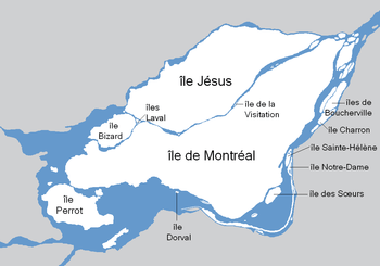
With the advent of the railroad, Montreal got a fixed link to the mainland; in 1854 railroad bridges were built in Sainte-Anne-de-Bellevue, across both channels of the Ottawa River, linking Montreal Island to Ontario and the Vaudreuil-Soulanges peninsula through Perrot Island.[3] In 1860, Montreal got its first link to the South Shore with the construction of Victoria Bridge, which was, at the time of its opening, the longest bridge in the world.[4] Indirect links to the North Shore also had to wait for railroad construction, but this took longer; the Canadian Pacific Railway opened its link to Saint-Jérôme in 1876, through Île Jésus.[2]
Crossings
This list of bridges and other fixed links serving the Island of Montreal proceeds counter-clockwise around the island from southwest, at the exit of Lake Saint-Louis, downstream along the St. Lawrence River, then upstream along Rivière des Prairies all the way to Lake of Two Mountains, then downstream again along the East Channel of the Ottawa River until it reaches Lake Saint-Louis. The year of construction is that of the structure currently in place, accompanied by the year of construction of the original structure if the current one replaced an older span.
| Key: Communities linked by individual bridges |
|---|
(M): Montreal-side municipality and borough
(I): Island(s) crossed, if any
(O): Opposite-side municipality and borough |
Spanning the Saint Lawrence River and Saint Lawrence Seaway
The crossing of the Saint Lawrence River has always proved problematic for engineers due to width, depth, currents, and ice cover. The construction of Victoria Bridge for the Grand Trunk Railway, which, at 2 kilometres (1.2 mi), was the longest bridge in the world when it first opened in 1860,[4] highlighted the problems presented by this natural obstacle.[5] Not to be outdone by its rival, however, the Canadian Pacific Railway built its own span, the Saint-Laurent Railway Bridge, upstream from the Lachine Rapids in 1886[6] for which the Mohawks of Kahnawake were hired to erect the steel superstructure.[7] Although Victoria Bridge was also used as a road crossing since 1898, it was not before the 1930s that two fully dedicated road bridges, Jacques-Cartier and Mercier, were built.[8][9] More spans, including Louis-Hippolyte Lafontaine Bridge–Tunnel and Champlain Bridge, were built in the 1960s.[10][11] No new structure has been built since, and none of the existing crossings have been upgraded or widened. A multibillion-dollar project to replace the Champlain Bridge is currently underway.
The construction of the Saint Lawrence Seaway in the 1950s required extensive modifications for all spans that existed at the time. Those are not reflected in the table below.
| Span | Picture | First span built | Current span built | Communities linked | Carries | Name origin | Coordinates |
|---|---|---|---|---|---|---|---|
| Saint-Laurent Railway Bridge | .jpg) |
1886 | 1910[6] | (M) Borough of LaSalle | Canadian Pacific Railway (CPR)
Réseau de transport métropolitain (RTM) Delson-Candiac (commuter train) |
Saint Lawrence River | 45°25′8″N 73°39′34″W |
| (O) Kahnawake Mohawk Reserve | |||||||
| Honoré Mercier Bridge | 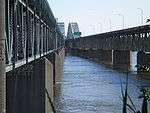 |
— |
1934, 1963[9][A] | (M) Borough of LaSalle | Route 138 |
Honoré Mercier (1840–1894), Premier of Quebec | 45°25′0″N 73°39′18″W |
| (O) Kahnawake Mohawk Reserve | |||||||
| Champlain Bridge Ice Structure | 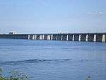 |
— |
1964[12][B] | (M) Borough of Verdun | Route Verte 1 and 2 | Samuel de Champlain (c. 1580–1635), founder of Quebec City | 45°27′57″N 73°31′11″W |
| (O) St. Lawrence Seaway levee | |||||||
| Champlain Bridge |  |
— |
1962[10][C] | (M) Borough of Verdun | Autoroutes 10, 15, and 20 |
45°28′7″N 73°31′15″W | |
| (I) Île des Sœurs (exit) | |||||||
| (O) Brossard | |||||||
| Victoria Bridge |  |
1860 | 1898[5][D] | (M) Borough of Le Sud-Ouest | Route 112 Canadian National Railway (CN) RTM Mont-Saint-Hilaire commuter train Via Rail and Amtrak passenger trains |
Queen Victoria of the United Kingdom (1819–1901) | 45°29′29″N 73°31′46″W |
| (O) Saint-Lambert | |||||||
| Pont de la Concorde and Pont des Îles | 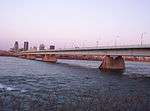 |
— |
1965[13][E] | (M) Borough of Ville-Marie | Pierre-Dupuy Avenue and Route Verte 1 and 2 | Reference to Montreal's motto, Concordia salus[13] | 45°30′22″N 73°32′17″W (Pont de la Concorde)
45°30′28″N 73°31′49″W (Pont des Îles) |
| (O) Île Sainte-Hélène and Île Notre-Dame (Parc Jean-Drapeau), borough of Ville-Marie, Montreal | |||||||
| Montreal Metro Tunnel |  |
— |
1966[14] | (M) Borough of Ville-Marie (Berri-UQAM station) | Line 4 Yellow | — |
45°30′N 73°32′W |
| (I) Île Sainte-Hélène (Jean-Drapeau station) and Île Notre-Dame | |||||||
| (O) Longueuil, borough of Vieux-Longueuil (Longueuil–Université-de-Sherbrooke station) | |||||||
| Jacques Cartier Bridge | 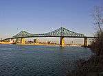 |
— |
1930[8][F] | (M) Borough of Ville-Marie | Route 134 Pedestrians and bicycles |
Jacques Cartier (1491–1557), French explorer | 45°31′17″N 73°32′28″W |
| (I) Île Sainte-Hélène (exit) and Île Notre-Dame | |||||||
| (O) Longueuil, borough of Vieux-Longueuil | |||||||
| Louis-Hippolyte Lafontaine Bridge–Tunnel | 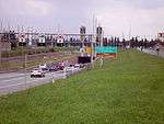 |
— |
1967[11][G] | (M) Borough of Mercier–Hochelaga-Maisonneuve | Autoroute 25 |
Louis-Hippolyte Lafontaine (1807–1864), Prime Minister of the United Province of Canada | 45°35′0″N 73°29′51″W |
| (I) Île Charron (Îles de Boucherville) (exit) | |||||||
| (O) Longueuil, borough of Vieux-Longueuil | |||||||
Spanning the Rivière des Prairies
Although the Rivière des Prairies is much smaller than the Saint Lawrence, bridge construction there did not begin until the 1840s—when rapid construction began on three wooden toll bridges to what is now Laval, one of which, Pont des Saints-Anges, collapsed in the 1880s and was never rebuilt.[2] The existence of regular ferry services across the river is attested from 1813,[15] but these ferries were discontinued when the bridges opened. The first railroad across the river was opened in 1876, and the Bordeaux Railway Bridge is the oldest fixed link to Laval that is still standing. (Another bridge across Rivière des Mille Îles, which was part of the same line, collapsed in 1882 but was immediately rebuilt.[2]) The highway construction boom of the 1960s and 1970s led to the construction of four new freeway bridges across the river, and the upgrading of the existing Pie IX Bridge to freeway standards.[2]
| Span | Picture | First span built | Current span built | Communities linked | Carries | Name origin | Coordinates |
|---|---|---|---|---|---|---|---|
| Le Gardeur Bridge | .jpg) |
— |
1939 (widened 1975)[16] | (M) Borough of Rivière-des-Prairies–Pointe-aux-Trembles | Route 138 and Route Verte 5 |
Pierre Le Gardeur de Repentigny (1605–1648), French lord[17] | 45°42′13″N 73°29′1″W |
| (I) Île Bourdon | |||||||
| (O) Repentigny | |||||||
| Laurier Railway Bridge[16] | .jpg) |
— |
1904[16] | (M) Borough of Rivière-des-Prairies–Pointe-aux-Trembles | CN | Wilfrid Laurier (1841–1919), Prime Minister of Canada | 45°42′10″N 73°29′8″W |
| (I) Île Bourdon | |||||||
| (O) Charlemagne | |||||||
| Charles de Gaulle Bridge | 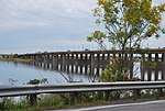 |
— |
1965[18] | (M) Borough of Rivière-des-Prairies–Pointe-aux-Trembles | Autoroute 40 |
Charles de Gaulle (1890–1970), President of France | 45°42′7″N 73°30′32″W |
| (O) Charlemagne | |||||||
| Olivier-Charbonneau Bridge | 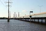 |
— |
2011 [H] | (M) Borough of Rivière-des-Prairies–Pointe-aux-Trembles | Olivier Charbonneau (c.1613-1687), first European settler of Île Jésus.[19] | 45°38′16″N 73°37′14″W | |
| (O) Laval (Saint-François) | |||||||
| Pie IX Bridge | .jpg) |
1937[2] | 1967[2] | (M) Borough of Montreal North | Route 125 |
Pope Pius IX (1792–1878) | 45°35′57″N 73°38′49″W |
| (O) Laval (Saint-Vincent-de-Paul) | |||||||
| Centrale de la Rivière des Prairies | .jpg) |
— |
1930[20][21][I] | (M) Borough of Ahuntsic-Cartierville | Hydro-Québec |
Rivière des Prairies | 45°35′17″N 73°39′21″W |
| (I) Île de la Visitation and Île du Cheval de Terre | |||||||
| (O) Laval (Duvernay) | |||||||
| Papineau-Leblanc Bridge | 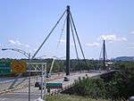 |
— |
1969[22] | (M) Borough of Ahuntsic-Cartierville | Autoroute 19 |
Louis-Joseph Papineau (1786–1871), leader of the Patriote movement Alpha Leblanc (1908–1962), local landowner[22] |
45°34′34″N 73°40′1″W |
| (I) Île de la Visitation | |||||||
| (O) Laval (Duvernay) | |||||||
| Viau Bridge (Ahuntsic Bridge) |  |
1847 | 1962 (widened 1993)[2] | (M) Borough of Ahuntsic-Cartierville | Route 335 |
Ahuntsic, Huron boy who drowned in 1625[23] The origin of the name Viau is uncertain.[24] | 45°33′26″N 73°40′32″W |
| (O) Laval (Pont-Viau) | |||||||
| Montreal Metro Tunnel | 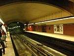 |
— |
2007[25] | (M) Borough of Ahuntsic-Cartierville (Henri-Bourassa station) | Line 2 Orange | — |
45°33′N 73°40′W |
| (O) Laval (Cartier station) | |||||||
| Bordeaux Railway Bridge | 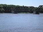 |
— |
1876[2] | (M) Borough of Ahuntsic-Cartierville | CPR RTM Saint-Jerome commuter train Quebec Gatineau Railway Route Verte 1 and 2 | Bordeaux, former town | 45°32′53″N 73°41′58″W |
| (I) Île Perry[26] | |||||||
| (O) Laval (Laval-des-Rapides) | |||||||
| Médéric Martin Bridge | 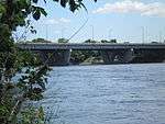 |
— |
1958 (widened 1991)[27] | (M) Borough of Ahuntsic-Cartierville | Autoroute 15 |
Médéric Martin (1869–1946), Mayor of Montreal | 45°32′25″N 73°42′45″W |
| (O) Laval (Laval-des-Rapides) | |||||||
| Lachapelle Bridge (Cartierville Bridge) | 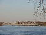 |
1848[2] | 1930, 1975[2] | (M) Borough of Ahuntsic-Cartierville | Route 117 |
Pascal Persillier-Lachapelle, builder of the first bridge[28] | 45°31′59″N 73°43′43″W |
| (O) Laval (Chomedey) | |||||||
| Louis Bisson Bridge | .jpg) |
— |
1975[29] | (M) Borough of Pierrefonds-Roxboro | Autoroute 13 |
Louis Bisson (1909–1997), Canadian aviator | 45°30′42″N 73°45′54″W |
| (O) Laval (Chomedey / Sainte-Dorothée) | |||||||
| Île Bigras railway crossing | 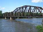 |
— |
1916[30][J] | (M) Borough of Pierrefonds-Roxboro | CN Owned by the RTM and mainly used by the Deux-Montagnes commuter train |
(no official name) | 45°30′59″N 73°50′52″W |
| (I) (Île Bigras) Île-Bigras commuter train station | |||||||
| (O) Laval (Sainte-Dorothée) | |||||||
| Jacques Bizard Bridge | 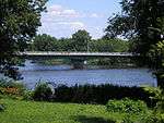 |
1893 | 1966[15] | (M) Sainte-Geneviève, Montreal, borough of L'Île-Bizard–Sainte-Geneviève | Boulevard Jacques Bizard | Jacques Bizard (1642–1692), local seigneur | 45°29′15″N 73°52′5″W |
| (O) Île Bizard (Montreal, borough of L'Île-Bizard–Sainte-Geneviève) | |||||||
Spanning the Lake of Two Mountains and the Ottawa River East Channel
The first railway bridge to Montreal Island was the Grand Trunk Railway bridge across the Ottawa River East Channel. Along with another bridge built simultaneously across the West Channel, this bridge provided the first fixed link from Montreal to the mainland.[3] It was not until 1925, however, that a fixed road link, formed by Galipeault Bridge and Taschereau Bridge, was built across the Ottawa River from Montreal Island.[31] Perrot Island was the only way out of Montreal to the West before the construction of Île aux Tourtes Bridge, which goes directly to Vaudreuil across the Lake of Two Mountains.[31]
All three spans across the Ottawa River East Channel are twinned by another span, built simultaneously, across the West Channel.
| Span | Picture | First span built | Current span built | Communities linked | Carries | Name origin | Coordinates |
|---|---|---|---|---|---|---|---|
| Île aux Tourtes Bridge |  |
— |
1966[31][K] | (M) Senneville | Autoroute 40 |
Île aux Tourtes (literally, Wild Pigeon island)[32] | 45°25′13″N 73°59′7″W (Across Lake of Two Mountains) |
| (I) Île Girwood, Île aux Tourtes | |||||||
| (O) Vaudreuil-Dorion | |||||||
| Canadian Pacific Rail Bridge | 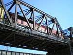 |
— |
1893[33] | (M) Sainte-Anne-de-Bellevue | CPR
(RTM Vaudreuil-Hudson commuter train) |
(no official names) | 45°24′12″N 73°57′24″W (Across Canal Sainte-Anne) |
| (I) Île Bellevue | |||||||
| (O) Île Perrot | |||||||
| Canadian National Rail Bridge | .jpg) |
— |
1854[3] | (M) Sainte-Anne-de-Bellevue | CN | 45°24′12″N 73°57′24″W (Across Canal Sainte-Anne) | |
| (I) Île Bellevue | |||||||
| (O) Île Perrot | |||||||
| Galipeault Bridge | 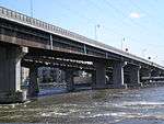 |
1925[31] | 1991, 2009[34][L] | (M) Sainte-Anne-de-Bellevue | Autoroute 20 and Route Verte 5 |
Antonin Galipeault (1879–1971), Quebec politician | 45°24′10″N 73°57′21″W (Across Canal Sainte-Anne) |
| (I) Île Bellevue | |||||||
| (O) Île Perrot | |||||||
See also
- Crossings of the Canal de l'Aqueduc
- Crossings of the Lachine Canal
- List of crossings of the Ottawa River
- List of crossings of the Rivière des Mille Îles
- Rivière des Prairies
- List of crossings of the Rivière des Prairies
- List of crossings of the Saint Lawrence River
- List of hydroelectric stations
- List of bridges in Canada
Notes
- A The section of Honoré-Mercier bridge spanning over the St. Lawrence Seaway was rebuilt to seaway standards in the 1950s. The bridge was twinned by an identical one, on the downriver side, which opened in 1963.[9]
- B The Champlain Bridge Ice Structure, known in French as "l'Estacade Champlain," was built to control ice floes coming from the Laprairie Basin.[12]
- C At the north end of Champlain Bridge, two spans, one north-south (aut. 15 and 20) and one east-west (aut. 10) connect Île des Sœurs to I. of Montreal. These two spans, called Pont Île-des-Sœurs and Pont Clément, are part of the Champlain Bridge complex.[10]
- D Victoria Bridge was built as a one-track tubular bridge which opened in 1860. It was the first bridge to cross the St. Lawrence River, and the longest bridge in the world. It was rebuilt as a two-track truss bridge in 1898. The South Y approach was rebuilt around the Saint-Lambert locks of the St. Lawrence Seaway in 1961.[5]
- E Pont de la Concorde (Concorde Bridge) and Pont des Îles ("Bridge of the Islands") were built for Expo 67.[13] Pont de la Concorde connects Montreal Island to Saint Helen's Island, while Pont des Îles connects Saint Helen's Island to Notre-Dame Island.
- F Jacques-Cartier Bridge was originally named Harbour Bridge/Pont du Havre, and renamed after Jacques Cartier in 1934 (400th anniversary of Cartier's first voyage). The section over the St. Lawrence Seaway was lifted to a new height in 1962.[8]
- G The Louis-Hippolyte Lafontaine complex consists of a tunnel from Montreal to Île Charron and a bridge from Île Charron to the South Shore.[11]
- H Construction of the Highway 25 Bridge started in early 2008 and was finished in May 2011. It is a toll bridge.
- I The Rivière des Prairies hydro complex is a set of three dams: one from Montreal I. to Île de la Visitation (west of the Papineau-Leblanc Bridge), which includes a footpath; another between Île de la Visitation and Île du Cheval de Terre; and the longest span between Île du Cheval-de-Terre and Île Jésus. Île de la Visitation is joined to Montreal by another two small bridges: a road bridge, which also serves as a dam (historically, a water mill) and a footbridge.
- J The railway crossing at Île Bigras consists of two spans, one north and one south of Île Bigras.
- K A structure known as "Île Bray Bridge" was abandoned while still under construction in favor of Île aux Tourtes Bridge.[31]
- L Galipeault Bridge was first built in 1925 and doubled in 1964. Both spans have been replaced since. Taschereau Bridge, which was part of the same project, spans the West Channel along the same highway.[31]
References
- The Encyclopedia Americana: a library of universal knowledge, Volume 19. University of Wisconsin – Madison. 1919. p. 415.
- Dion, Richard; André Bernier; Serge Philibert; Georges Leahy; Sylvie Lalonde (1981). Analyse historique et architecturale sur le patrimoine lavallois, volume 1 (in French). Pluram Inc. pp. 47–51.
- Sainte-Anne-de-Bellevue 1703–2003. Paroisse Sainte-Anne-de-Bellevue. 2003. pp. 125, 130. ISBN 2-9808057-0-X.
- Sweetser, Moses Foster (1877). New England; a handbook for travellers. J.R. Osgood and co. p. 391.
- "The Victoria Bridge". City of Montreal. 2003. Retrieved 2009-09-14.
- Werry, S.D. (1997). "Rails across the river: the story of the St. Lawrence Bridge (1881–1915)". Can. J. Civ. Eng. 24: 480–488.
- Johansen, Bruce Elliott (1999). The encyclopedia of Native American economic history. Westport, CT: Greenwood Press. p. 166. ISBN 978-0-313-30623-5.
- "The Jacques Cartier Bridge: History". Jacques Cartier and Champlain Bridges Incorporated. Archived from the original on 2009-07-05. Retrieved 2009-09-14.
- Les Ponts Jacques-Cartier et Champlain Incorporée. "Histoire du pont Mercier" (in French). Les Ponts Jacques-Cartier et Champlain Incorporée. Archived from the original on 2001-05-25. Retrieved 2009-07-20.CS1 maint: uses authors parameter (link)
- "The Champlain Bridge and Bonaventure Expressway". Jacques Cartier and Champlain Bridges Incorporated. Archived from the original on 2010-07-29. Retrieved 2009-09-14.
- "Pont-tunnel Louis-Hippolyte-La Fontaine (40 ans)" (in French). Transports Québec. Archived from the original on 2011-07-16. Retrieved 2009-08-19. |language=French
- "The Champlain Bridge Ice Control Structure". Les Ponts Jacques-Cartier et Champlain Incorporée. Archived from the original on 2011-06-14. Retrieved 2009-07-20.
- "Fiche toponymique" (in French). Commission de toponymie du Québec. 2007. Retrieved 2009-08-24.
- "Important dates in STM's history". Société de Transport de Montréal. Archived from the original on 2009-06-21. Retrieved 2009-09-14.
- Boulanger, Micheline; et al. (2008). Histoire de l'Île Bizard (in French). Éditions Histoire Québec. p. 138. ISBN 978-2-89586-038-9.
- Charlemagne et son histoire (in French). Comité des fêtes du soixante-quinzième anniversaire de Charlemagne. 1986. pp. 134–135. ISBN 2-9800711-1-0.
- Marchi, François (2007). "Pierre Le Gardeur (1605–1648)" (in French). Retrieved 2009-08-24.
- Lachenaie: 300 ans d'histoire à découvrir (in French). Corporation du Tricentenaire de Lachenaie. 1983. p. 400.
- "Fiche toponymique" (in French). Commission de toponymie du Québec. 2012. Retrieved 2012-06-20.
- Fortin, Jean-Claude; Jacques Saint-Pierre; Normand Perron (2008). Histoire de Laval (in French). Institut national de la recherche scientifique. p. 109. ISBN 978-2-7637-8859-3.
- "La centrale de la Rivière-des-Prairies". Hydro-Québec. Retrieved 2009-07-20. [Hydro-Québec]
- "Fiche toponymique" (in French). Commission de toponymie du Québec. 2007. Retrieved 2009-08-24.
- "Fiche toponymique" (in French). Commission de toponymie du Québec. 2007. Retrieved 2009-08-24.
- "Fiche toponymique" (in French). Commission de toponymie du Québec. 2007. Retrieved 2009-08-30.
- "A glorious day for transit in Laval". Montreal Gazette. 2007-04-27. Archived from the original on 2012-11-07. Retrieved 2009-09-14.
- Île Perry
- Fortin, Jean-Claude; Jacques Saint-Pierre; Normand Perron (2008). Histoire de Laval (in French). Institut national de la recherche scientifique. p. 210. ISBN 978-2-7637-8859-3.
- "Fiche toponymique" (in French). Commission de toponymie du Québec. 2007. Retrieved 2009-08-24.
- Fortin, Jean-Claude; Jacques Saint-Pierre; Normand Perron (2008). Histoire de Laval (in French). Institut national de la recherche scientifique. pp. 249–250. ISBN 978-2-7637-8859-3.
- Andreae, Christopher (1997). Lines of Country: An Atlas of Railway and Waterway History in Canada. The Boston Mills Press. p. 107. ISBN 1-55046-133-8.
- Bélisle, Michel (2007). De l'Isle aux Tourtes à Vaudreuil-Dorion (in French). Collectif pour l'histoire de Vaudreuil-Dorion. p. 263. ISBN 978-2-9810200-0-0.
- Fiche descriptive
- Sainte-Anne-de-Bellevue 1703–2003. Paroisse Sainte-Anne-de-Bellevue. 2003. p. 125. ISBN 2-9808057-0-X.
- Jason Magder. "Galipeault span to get $98-million facelift". Montreal Gazette. Archived from the original on 2010-09-15. Retrieved 2008-07-02.
| Features |
|  | |||||
|---|---|---|---|---|---|---|---|
| History |
| ||||||
| Geography |
| ||||||
| Economy |
| ||||||
| Politics |
| ||||||
| Public services |
| ||||||
| Education |
| ||||||
| Culture |
| ||||||
| Transportation |
| ||||||
| |||||||
| North–south streets |
| ||||
|---|---|---|---|---|---|
| East–west streets |
| ||||
| Expressways |
| ||||
| Routes |
| ||||
| Bridges and tunnels |
| ||||
| |||||