Interstate 80 in Nevada
Interstate 80 (I-80) traverses the northern portion of the U.S. state of Nevada. The freeway serves the Reno–Sparks metropolitan area and passes through the towns of Fernley, Lovelock, Winnemucca, Battle Mountain, Carlin, Elko, Wells and West Wendover on its way through the state.
| ||||
|---|---|---|---|---|
| Dwight D. Eisenhower Highway Purple Heart Trail | ||||
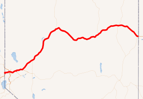
I-80 highlighted in red | ||||
| Route information | ||||
| Maintained by NDOT | ||||
| Length | 410.681 mi[1] (660.927 km) | |||
| Existed | June 29, 1956[2]–present | |||
| Major junctions | ||||
| West end | ||||
| ||||
| East end | ||||
| Location | ||||
| Counties | Washoe, Storey, Lyon, Churchill, Pershing, Humboldt, Lander, Eureka, Elko | |||
| Highway system | ||||
| ||||
.svg.png)
I-80 follows the historical routes of the California Trail, First Transcontinental Railroad and Feather River Route throughout portions of Nevada. Throughout the entire state, I-80 follows the historical routes of the Victory Highway, State Route 1 and U.S. Route 40 (US 40). The freeway corridor follows the paths of the Truckee and Humboldt Rivers. These rivers have been used as a transportation corridor since the California Gold Rush of the 1840s.
The Nevada portion of I-80 is designated the Dwight D. Eisenhower Highway and Purple Heart Trail.
Route description
Truckee River
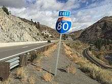
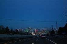
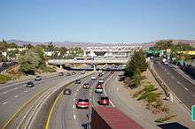
I-80 enters Nevada in the canyon of the Truckee River, paralleling the California Trail and the First Transcontinental Railroad. Upon exiting the canyon, the freeway serves the Truckee Meadows, a name for the urban area consisting of Verdi, Reno and Sparks. The freeway passes north of Downtown Reno in a depressed alignment before intersecting Interstate 580 / U.S. Route 395. The interchange with US 395 is the busiest portion, averaging 122,000 vehicles per day in 2006.[3] The freeway passes through downtown Sparks via a viaduct over the casino floor of the Nugget Casino Resort. After leaving the Reno–Sparks metropolitan area the freeway resumes following the Truckee River in a canyon to Fernley and passes the Northern Nevada Veterans Cemetery to the north. Traffic volumes drop to 26,600 vehicles per day by Fernley and continue dropping to 8,400 by the time the freeway reaches the center of the state.[3] The freeway exits the Truckee River corridor near Wadsworth.[4]
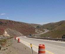
Lahontan Valley/Forty Mile Desert
Past Wadsworth, the freeway cuts across the Lahontan Valley. The Lahontan Valley is a barren desert, sometimes called the Forty Mile Desert, from the era of the California Trail. The name comes from the California Gold Rush where the emigrants who came into the Lahontan Valley via the Humboldt River. The travelers would have then to endure 40 miles (64 km) without usable water while crossing the valley, regardless of which of the two routes across the valley the travelers followed.[5] I-80 closely approximates the path of the emigrants between the Humboldt and Truckee Rivers. Between eastern Fernley and Winnemucca, the speed limit was raised from 75 to 80 mph (129 km/h) in 2017.[6]
A marker stands at a rest area on the eastern edge of the valley, near the junction of I-80 and US 95, that honors travelers who suffered crossing the valley, thousands of whom abandoned possessions, animals and even loved ones in the desert. Per the marker, this portion was the most dreaded portion of the California Trail.[4][5][7]
Humboldt River
For the next 246 miles (396 km), I-80 follows the Humboldt River.[8][9] Along the way, the freeway passes through the towns of Lovelock, Winnemucca, Battle Mountain, Carlin, Elko and Wells. At Winnemucca, I-80 is joined by the Feather River Route; I-80 runs parallel to this railroad until the Utah state line.[4]
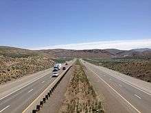
The freeway is within visual distance of the river for most of this run. However, there are portions where the freeway bypasses bends by cutting across or tunneling under mountains along the canyon walls. Between Winnemucca and Battle Mountain, the freeway bypasses bends via side canyons and Golconda Summit, 5,159 feet (1,572 m).[4] The highway also bypasses Palisade Canyon (between Beowawe and Carlin) via Emigrant Pass 6,114 feet (1,864 m).[4] Just east of Carlin, I-80 passes through the Carlin Tunnel to bypass curves of the river in the Carlin Canyon (between the Carlin Tunnel and Elko).[10]
Eastern Nevada
.jpg)
After Wells, I-80 departs the Humboldt River, First Transcontinental Railroad and the California Trail.[4] From this point east, the freeway follows the routes of the Hastings Cutoff, Feather River Route, former US 40 and State Route 1. The freeway cuts across two mountain ranges before arriving at the Great Salt Lake Desert. The first is the Pequop Mountains via Pequop Summit, elevation 6,967 feet (2,124 m)—the highest point on Interstate 80 in Nevada—and the second is the Toano Range via Silver Zone Pass at 5,955 feet (1,815 m). After crossing these mountains the freeway arrives at West Wendover where the freeway enters both Utah and the Great Salt Lake Desert at the Bonneville Salt Flats.[4]
Overlaps
Portions of I-80 run concurrently with three U.S. Highways in Nevada:[9]
- US 95 Alt, which runs concurrently with I-80 between Fernley and Trinity Junction near Lovelock.
- US 95, which runs concurrently with I-80 between Trinity Junction and Winnemucca.
- US 93 Alt, which runs concurrently with I-80 between the cities of Wells and West Wendover.
History
California Trail
The general route of Interstate 80 was first used by California-bound travelers and was called the California Trail. From the Utah State line west to the Humboldt River, I-80 follows a modified routing of a lesser used branch of the trail called Hastings Cutoff. The cutoff rejoins the main route of the trail in the Humboldt River canyon. Through this portion of Nevada, the main route of the California Trail ran north of modern State Route 233.
From Elko west to Lovelock, I-80 faithfully follows the California Trail. West of Lovelock, in the middle of the Humboldt Sink, the California Trail again splits into two branches. These branches, the Carson River route and the Truckee River route, are named for the waterways that guide each branch up the Sierra Nevada mountains. I-80 follows the Truckee route, the Carson route is approximated by U.S. Route 95, U.S. Route 50, U.S. Route 395 and State Route 88 / California State Route 88.[4]
Transcontinental railroads
The route of modern I-80 was also previously used for the construction of two transcontinental railroads. The First Transcontinental Railroad, completed in 1869, closely followed the main line of the California Trail and I-80 west of Wells. The Feather River Route was constructed in 1909 and generally follows the Hastings Cutoff through Eastern Nevada. It also runs parallel to I-80 in Nevada east of Winnemucca.[4]
Highways
The first paved road across this portion of Nevada was the Victory Highway, designated in Nevada as State Route 1. With the formation of the U.S. Highway system, this route was numbered U.S. Route 40. From the formation of the Interstate Highway System, the highway was gradually upgraded to Interstate Highway standards and signed as Interstate 80. In 1974, officials in Utah initiated meetings with officials in Nevada and California to truncate the route of U.S. Route 91. By that time, US 91 was mostly redundant with Interstate 15. Nevada officials agreed and further suggested that both US 91 and US 40 be truncated. Nevada officials recommended the changes occur in 1975, when the last Nevada piece of I-15 was expected to be completed.[11] The 1976 edition of the Official Highway map for Nevada was the first not showing the US 40 designation.[12] Even though the US Highway designation was removed, the freeway was not yet completed.[12] The last piece of I-80 in Nevada to be finished was the Lovelock bypass which started construction in 1981.[13] The 1982 Official Nevada Highway Map was the first to note I-80 as a contiguous freeway across the state. All of the business loops for I-80 in Nevada use the historical route of US 40.
Interstate 80 is also known in Nevada as the Dwight D. Eisenhower Highway and the Purple Heart Trail.[12]
Exit list
| County | Location | mi[9] | km | Exit | Destinations | Notes | ||
|---|---|---|---|---|---|---|---|---|
| Washoe | Verdi | 0.0 | 0.0 | — | Continuation into California | |||
| 1 | Verdi (I-80 Bus. east) | Westbound exit and entrance; former US 40 | ||||||
| 2.8 | 4.5 | 2 | Verdi (I-80 Bus. east to SR 425) | No westbound entrance; former US 40 | ||||
| 3.2 | 5.1 | 3 | Verdi | Westbound exit and eastbound entrance | ||||
| 4.8 | 7.7 | 4 | Boomtown Garson Road | |||||
| 5.7 | 9.2 | 5 | East Verdi (I-80 Bus. west / SR 425 west) | Westbound exit and eastbound entrance; former US 40 west | ||||
| Mogul | 7.0 | 11.3 | 7 | Mogul | ||||
| Reno | 7.7 | 12.4 | 8 | West 4th Street (SR 647 east) | Eastbound exit and westbound entrance; former US 40 east | |||
| 9.2 | 14.8 | 9 | Robb Drive | |||||
| 10.7 | 17.2 | 10 | McCarran Boulevard West (SR 659) | Former SR 651 | ||||
| 12.5 | 20.1 | 12 | Keystone Avenue (I-80 Bus. east) | Former SR 657 | ||||
| 13.3 | 21.4 | 13 | Virginia Street (US 395 Bus.), Downtown | Serves University of Nevada, Reno; Sierra Street was former SR 660; Virginia Street was former SR 430/US 395 | ||||
| 14.1 | 22.7 | 14 | Wells Avenue | Serves Reno-Sparks Livestock Events Center | ||||
| 14.9 | 24.0 | 15 | Serves Reno–Tahoe International Airport and Reno-Sparks Convention Center; I-580 exit 36 and US 395 exit 68 | |||||
| Sparks | 15.4 | 24.8 | 16 | Prater Way, East 4th Street (I-80 Bus. / SR 647 west) | Former US 40 | |||
| 16.1 | 25.9 | 17 | Rock Boulevard (SR 668) | Serves Victorian Square; also signed for Nugget Avenue eastbound | ||||
| 16.8 | 27.0 | 18 | Serves Victorian Square | |||||
| 17.6 | 28.3 | 19 | McCarran Boulevard East (SR 659 to I-80 Bus. west) | McCarran Boulevard was former SR 650; Victorian Avenue was former US 40 west | ||||
| 18.9 | 30.4 | 20 | Sparks Boulevard | |||||
| 19.7 | 31.7 | 21 | Vista Boulevard, Greg Street | |||||
| Lockwood | 22.6 | 36.4 | 22 | Lockwood | ||||
| McCarran | 24.0 | 38.6 | 23 | Mustang | ||||
| Patrick | 28.2 | 45.4 | 28 | Patrick (Waltham Way, SR 655 south) | ||||
| Clark | 32.1 | 51.7 | 32 | Serves Tahoe Reno Industrial Center; replaced former Tracy, Clark Station exit on January 21, 2008 | ||||
| | 36.9 | 59.4 | 36 | Derby Dam | ||||
| | 39.0 | 62.8 | 38 | Orchard | ||||
| | 40.2 | 64.7 | 40 | Painted Rock | ||||
| Wadsworth | 44.0 | 70.8 | 43 | Wadsworth (I-80 Bus. east / SR 427 east) | Serves Pyramid Lake; Main Street was former US 40 east | |||
| Storey |
No major junctions | |||||||
| Lyon | Fernley | 46.4 | 74.7 | 46 | West Fernley (I-80 Bus. / SR 427) | Also signed "To US 95 Alt. south" eastbound; serves Wadsworth and Pyramid Lake; former US 40 | ||
| 48.9 | 78.7 | 48 | Western end of US 95 Alt. concurrency; former US 40 west/US 95 south | |||||
| 50.1 | 80.6 | 50 | Nevada Pacific Parkway | Opened on June 19, 2009 | ||||
| Churchill | | 65.2 | 104.9 | 65 | Nightingale Hot Springs | |||
| | 78.9 | 127.0 | 78 | Jessup | ||||
| Trinity | 83.3 | 134.1 | 83 | Eastern end of US 95 Alt. concurrency; western end of US 95 concurrency | ||||
| Pershing | Toulon | 93.5 | 150.5 | 93 | Toulon | Serves Derby Field | ||
| Lovelock | 105.5 | 169.8 | 105 | West Lovelock (I-80 Bus. east / SR 396 north) | Eastbound exit and westbound entrance; former US 40 east/US 95 north | |||
| 106.4 | 171.2 | 106 | Downtown Lovelock (SR 398 north) | |||||
| 107.2 | 172.5 | 107 | East Lovelock (I-80 Bus. west / SR 856) | Westbound exit and eastbound entrance | ||||
| 112.9 | 181.7 | 112 | Coal Canyon (SR 396 south) | Former US 40 west/US 95 south | ||||
| Oreana | 120.2 | 193.4 | 119 | Oreana, Rochester | Former SR 858 east | |||
| | 129.6 | 208.6 | 129 | Rye Patch Dam (SR 401 west) | ||||
| Humboldt | 138.7 | 223.2 | 138 | Humboldt | ||||
| Imlay | 146.0 | 235.0 | 145 | Imlay | ||||
| Mill City | 150.3 | 241.9 | 149 | |||||
| 152.1 | 244.8 | 151 | Mill City, Dun Glen | No westbound entrance | ||||
| Cosgrave | 158.7 | 255.4 | 158 | Cosgrave | ||||
| Humboldt | Rose Creek | 168.4 | 271.0 | 168 | Rose Creek | |||
| Winnemucca | 173.4 | 279.1 | 173 | West Winnemucca Boulevard | Serves Winnemucca Municipal Airport; former US 40 east | |||
| 176.7 | 284.4 | 176 | Eastern end of US 95 concurrency; former US 40 | |||||
| 179.0 | 288.1 | 178 | ||||||
| 180.8 | 291.0 | 180 | East Winnemucca Boulevard was former US 40 west | |||||
| Button Point | 187.7 | 302.1 | 187 | Button Point | ||||
| Golconda | 194.5 | 313.0 | 194 | Golconda, Midas (SR 789 north) | ||||
| | 200.5 | 322.7 | 200 | Golconda Summit | ||||
| | 204.1 | 328.5 | 203 | Iron Point | ||||
| | 205.6 | 330.9 | 205 | Pumpernickel Valley | ||||
| Stone House | 212.5 | 342.0 | 212 | Stone House | ||||
| Valmy | 217.2 | 349.5 | 216 | Valmy | ||||
| | 222.7 | 358.4 | 222 | Mote | ||||
| Lander | Battle Mountain | 230.2 | 370.5 | 229 | Front Street was former US 40 east | |||
| 231.7 | 372.9 | 231 | ||||||
| 233.6 | 375.9 | 233 | Front Street was former US 40 west; serves Battle Mountain Airport | |||||
| Argenta | 244.7 | 393.8 | 244 | Argenta | ||||
| Eureka | Dunphy | 254.5 | 409.6 | 254 | Dunphy | |||
| | 261.4 | 420.7 | 261 | |||||
| | 269.2 | 433.2 | 268 | Emigrant Pass | ||||
| | 271.6 | 437.1 | 271 | Palisade | ||||
| Elko | Carlin | 280.0 | 450.6 | 279 | Chestnut Street was former US 40 east | |||
| 281.4 | 452.9 | 280 | ||||||
| 282.7 | 455.0 | 282 | ||||||
| Hunter | 293.3 | 472.0 | 292 | Hunter | ||||
| Elko | 299.2 | 481.5 | 298 | Elko West (I-80 Bus. east / SR 535 east) | Former US 40 east | |||
| 301.9 | 485.9 | 301 | ||||||
| 304.4 | 489.9 | 303 | Elko East (I-80 Bus. west ) | |||||
| Osino | 311.5 | 501.3 | 310 | Osino | Idaho Street was former US 40 west | |||
| Ryndon | 315.5 | 507.7 | 314 | Ryndon, Devils Gate | CR 742 | |||
| 317.7 | 511.3 | 317 | Elburz, Devils Gate | CR 745 | ||||
| Halleck | 322.2 | 518.5 | 321 | |||||
| | 329.0 | 529.5 | 328 | River Ranch | ||||
| Deeth | 334.5 | 538.3 | 333 | Deeth, Starr Valley (SR 230 east) | Former US 40 east | |||
| Welcome | 344.4 | 554.3 | 343 | Welcome, Starr Valley (SR 230 west) | Former US 40 west | |||
| Beverly Hills | 348.2 | 560.4 | 348 | Beverly Hills | ||||
| Wells | 351.6 | 565.8 | 351 | West Wells (I-80 Bus. east / SR 223 east / SR 231 south) | Former US 40 east | |||
| 352.5 | 567.3 | 352A | Western end of US 93 Alt. concurrency; signed as exit 352 eastbound | |||||
| 352B | East Wells (I-80 Bus. west / 6th Street) | Westbound exit only; former US 40 west | ||||||
| Moor | 360.7 | 580.5 | 360 | Moor | ||||
| Independence Valley | 365.9 | 588.9 | 365 | Independence Valley | ||||
| Pequop Summit | 373.8 | 601.6 | 373 | Pequop Summit | ||||
| Pequop | 376.5 | 605.9 | 376 | Pequop | ||||
| Oasis | 379.4 | 610.6 | 378 | |||||
| | 388.1 | 624.6 | 387 | Shafter | CR 789 | |||
| | 399.2 | 642.5 | 398 | Pilot Peak | CR 767 | |||
| West Wendover | 407.2 | 655.3 | 407 | Ola | ||||
| 410.4 | 660.5 | 410 | Eastern end of US 93 Alt. concurrency | |||||
| 410.7 | 661.0 | — | Continuation into Utah | |||||
1.000 mi = 1.609 km; 1.000 km = 0.621 mi
| ||||||||
See also

References
- Nevada Department of Transportation (January 2017). "State Maintained Highways of Nevada: Descriptions and Maps". Retrieved May 11, 2017.
- Weingroff, Richard F. "Federal-Aid Highway Act of 1956: Creating the Interstate System". Federal Highway Administration. Retrieved May 11, 2008.
- "2006 Annual Traffic Report". Nevada Department of Transportation. Retrieved October 19, 2019.
- Nevada Road and Recreation Atlas (Map). 1:250000. Benchmark Maps. 2003. p. 47. ISBN 0-929591-81-X.
- "Forty Mile Desert". Nevada State Historic Preservation Office. Retrieved October 19, 2019.
- "Nevada joins handful of states with spans of 80 mph driving". Vancouver Sun. Archived from the original on September 13, 2017. Retrieved September 13, 2017.
- Brock, Dick. "Photos and transcription of markers along the Forty Mile Desert, placed by the Oregon/California Trails Association". Trails West Inc. Retrieved May 18, 2014.
- Using distance between Lovelock and Wells
- 2019–2020 Official Highway Map (Map). Nevada Department of Transportation. 2019. Retrieved October 19, 2019.
- Turner, Dan. "Carlin Canyon, Elko County, Nevada". Elko Rose Garden Association. Archived from the original on May 18, 2014. Retrieved January 26, 2013.
- "Highway Resolution route 91". Utah Department of Transportation. Retrieved March 8, 2008.
- "Historical Maps". Nevada Department of Transportation. Retrieved January 26, 2013.
- "NDOT News Spring 2006" (PDF). Nevada Department of Transportation. 2006. Retrieved January 26, 2013.
External links
| Wikimedia Commons has media related to Interstate 80 in Nevada. |
| Previous state: California |
Nevada | Next state: Utah |
Auxiliary routes of Interstate 80 | ||
|---|---|---|
| ||
| ||