Hurricane Michael
Hurricane Michael was a very powerful and destructive tropical cyclone that became the first Category 5 hurricane to strike the contiguous United States since Andrew in 1992. In addition, it was the third-most intense Atlantic hurricane to make landfall in the contiguous United States in terms of pressure, behind the 1935 Labor Day hurricane and Hurricane Camille in 1969. It was the first Category 5 hurricane on record to impact the Florida Panhandle, the fourth-strongest landfalling hurricane in the contiguous United States, in terms of wind speed, and was the most intense hurricane on record to strike the United States in the month of October.
| Category 5 major hurricane (SSHWS/NWS) | |
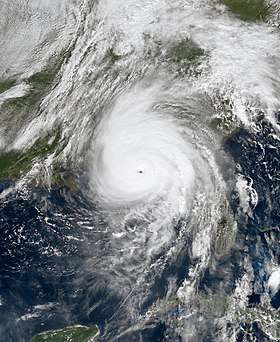 Hurricane Michael making landfall on the Florida Panhandle at peak intensity on October 10 | |
| Formed | October 7, 2018 |
|---|---|
| Dissipated | October 16, 2018 |
| (Extratropical after October 11) | |
| Highest winds | 1-minute sustained: 160 mph (260 km/h) |
| Lowest pressure | 919 mbar (hPa); 27.14 inHg |
| Fatalities | 31 direct, 43 indirect |
| Damage | $25.1 billion (2018 USD) |
| Areas affected | Central America, Yucatán Peninsula, Cayman Islands, Cuba, Southeastern United States (especially the Florida Panhandle and Georgia), Eastern United States, Eastern Canada, Iberian Peninsula |
| Part of the 2018 Atlantic hurricane season | |
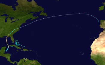
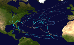
The thirteenth named storm, seventh hurricane, and second major hurricane of the 2018 Atlantic hurricane season, Michael originated from a broad low-pressure area that formed in the southwestern Caribbean Sea on October 1. The disturbance became a tropical depression on October 7, after nearly a week of slow development. By the next day, Michael had intensified into a hurricane near the western tip of Cuba, as it moved northward. The hurricane rapidly intensified in the Gulf of Mexico, reaching major hurricane status on October 9. As it approached the Florida Panhandle, Michael reached Category 5 status with peak winds of 160 mph (260 km/h)[1] just before making landfall near Mexico Beach, Florida, on October 10, becoming the first to do so in the region as a Category 5 hurricane, and as the strongest storm of the season. As it moved inland, the storm weakened and began to take a northeastward trajectory toward Chesapeake Bay, downgrading to a tropical storm over Georgia, and transitioning into an extratropical cyclone over southern Virginia late on October 11. Michael subsequently strengthened into a powerful extratropical cyclone and eventually impacted the Iberian Peninsula, before dissipating on October 16.
At least 74 deaths were attributed to the storm, including 59 in the United States and 15 in Central America. Michael caused an estimated $25.1 billion (2018 USD) in damages,[2] including $100 million in economic losses in Central America,[3] damage to U.S. fighter jets with a replacement cost of approximately $6 billion at Tyndall Air Force Base,[4] and at least $6.23 billion in insurance claims in the U.S.[5][6] Losses to agriculture alone exceeded $3.87 billion.[7][8] As a tropical disturbance, the system caused extensive flooding in Central America in concert with a second disturbance over the eastern Pacific Ocean. In Cuba, the hurricane's winds left over 200,000 people without power as the storm passed to the island's west. Along the Florida panhandle, the cities of Mexico Beach and Panama City suffered the worst of Michael, with catastrophic damage reported due to the extreme winds and storm surge. Numerous homes were flattened and trees felled over a wide swath of the panhandle. A maximum wind gust of 139 mph (224 km/h) was measured at Tyndall Air Force Base before the sensors failed. As Michael tracked across the Southeastern United States, strong winds caused extensive power outages across the region.
Meteorological history
On October 1, a broad area of low pressure formed over the southwestern Caribbean Sea, absorbing the remnants of Tropical Storm Kirk by the next day.[1] Early on October 2, the National Hurricane Center (NHC) began monitoring the system for tropical development.[9] On the same day, the disturbance experienced a burst of convection, possibly associated with a tropical wave moving into the region, which led to a small surface low forming to the southwest of Jamaica on October 3.[1] While strong upper-level winds initially inhibited development, the disturbance gradually became better organized as it drifted generally northward and then westward toward the Yucatán Peninsula. By October 6, the disturbance had developed well-organized deep convection, although it still lacked a well-defined circulation. The storm was also posing an immediate land threat to the Yucatán Peninsula and Cuba. Thus, the NHC initiated advisories on Potential Tropical Cyclone Fourteen at 21:00 UTC that day.[10][11] By the morning of October 7, radar data from Belize found a closed center of circulation, while satellite estimates indicated a sufficiently organized convective pattern to classify the system as a tropical depression.[12] The newly-formed tropical cyclone then quickly strengthened into Tropical Storm Michael at 12:00 UTC that day.[1] The nascent system meandered before the center of circulation relocated closer to the center of deep convection, as reported by reconnaissance aircraft that was investigating the storm.[13] Despite moderate vertical wind shear, Michael proceeded to strengthen quickly, becoming a high-end tropical storm early on October 8, as the storm's cloud pattern became better organized.[14] Continued intensification occurred, and Michael attained hurricane status later on the same day.[1]
| Strongest U.S. landfalling tropical cyclones | |||||
|---|---|---|---|---|---|
| Rank | Storm Name |
Season | Wind speed | ||
| mph | km/h | ||||
| 1 | "Labor Day" | 1935 | 185 | 295 | |
| 2 | Karen | 1962 | 175 | 280 | |
| Camille | 1969 | ||||
| Yutu | 2018 | ||||
| 5 | Andrew | 1992 | 165 | 270 | |
| 6 | "Okeechobee" | 1928 | 160 | 260 | |
| Michael | 2018 | ||||
| 8 | "Guam" | 1900 | 155 | 250 | |
| Maria | 2017 | ||||
| 10 | |||||
| "Last Island" | 1856 | 150 | 240 | ||
| "Indianola" | 1886 | ||||
| "Florida Keys" | 1919 | ||||
| "Freeport" | 1932 | ||||
| Charley | 2004 | ||||
| Source: HURDAT,[15] Hurricane Research Division,[16] NHC[17] | |||||
upon striking land. | |||||
Storms landfalling on the US Pacific Territories are referred to as typhoons. | |||||
Shortly afterwards, rapid intensification ensued and very deep bursts of convection were noted within the eyewall of the growing hurricane, as it passed through the Yucatán Channel into the Gulf of Mexico late on October 8, clipping the western end of Cuba at Category 2 intensity.[1] Meanwhile, a 35-nautical-mile-wide (65 km) eye was noted to be forming.[18] The intensification process accelerated on October 9, with Michael becoming a major hurricane at 18:00 UTC that day.[1] Rapid intensification continued throughout the day on October 10 as a well-defined eye appeared, culminating with Michael achieving its peak intensity at 17:30 UTC as a Category 5 hurricane, with maximum sustained winds of 160 mph (260 km/h) and a minimum central pressure of 919 millibars (27.1 inHg). In just under 24 hours, its central pressure had fallen by 42 mbar (1.2 inHg). Simultaneously, Michael made landfall on the Gulf Coast of the United States near Mexico Beach, Florida, ranking by pressure as the third-most intense Atlantic hurricane to ever make landfall in the United States,[1] and making it the first Category 5 hurricane to strike the contiguous United States since Hurricane Andrew in 1992. The storm was originally considered a high-end Category 4 hurricane, but post-season reanalysis (which the NHC routinely performs for every tropical cyclone in their area of responsibility) concluded that it was indeed a Category 5 hurricane at this point.[1][19]
.jpg)
Michael maintained Category 5 intensity for less than one hour; once inland, Michael began to rapidly weaken, as it moved over the inner Southeastern United States, with the eye dissipating from satellite view, weakening to a tropical storm roughly twelve hours after it made landfall.[1] Moving into the Carolinas early on October 11, the inner core of the storm collapsed as the storm's rainbands became prominent to the north of the center. Later that day, Michael began to show signs of becoming an extratropical cyclone, as it accelerated east-northeastward toward the Mid-Atlantic coastline, with cooler air beginning to wrap into the elongating circulation, due to an encroaching frontal zone;[20] it became extratropical at 00:00 UTC October 12.[1] Afterward, Michael began to restrengthen while moving off the coast, due to baroclinic forcing. Michael subsequently accelerated towards the east, strengthening into a powerful extratropical cyclone by October 14.[21] On October 15, Michael's extratropical remnant approached the Iberian Peninsula and turned sharply towards the southeast,[22] making landfall on Portugal early on October 16. Soon afterward, Michael's extratropical remnant absorbed the remnants of Hurricane Leslie to the east, following a brief Fujiwhara interaction.[23] Afterward, Michael's remnant quickly weakened, dissipating over Spain later on the same day.[24][23][25]
Preparations
Cuba
About 300 people were evacuated from the coast of western Cuba, due to the storm.[26]
United States
.jpg)
On October 7, Governor Rick Scott announced that he would be declaring a state of emergency for Florida if needed, advising residents to be prepared for the incoming storm.[27] That day, a state of emergency was declared for 26 counties, and then 9 additional counties were added on October 8. Governor Scott also requested that President Donald Trump issue an emergency disaster declaration for 35 counties, with Trump approving of the request on October 9.[28] Officials in Bay, Gulf, and Wakulla counties issued mandatory evacuation orders on October 8 for those living near the coast, in mobile homes, or in other weak dwellings.[29] Florida State University's main campus in Tallahassee and a satellite campus in Panama City, Florida, were closed from October 9 through October 12. Florida A&M University and Tallahassee Community College closed several campuses through October 14, while weekend classes and events were canceled at the former.[30] Public schools were closed in 26 counties, mainly in the Florida Panhandle.[28] On October 8, Hurricane and Tropical Storm Warnings and Watches were issued for the Gulf Coast.
Georgia Governor Nathan Deal declared a state of emergency for 92 counties in the southern and central portions of the state on October 9. Several colleges and universities in south Georgia were to close for a few days.[31] Atlanta Motor Speedway opened their campgrounds free of charge to evacuees of Hurricane Michael.[32]
375,000 people were asked to evacuate as the storm strengthened, with sustained winds of 150 mph (240 km/h) and storm surge up to 14 ft (4.3 m) expected.[33] Emergency Preparedness organizations like Direct Relief provided emergency medical packs throughout ten health facilities that were in Michael's path.[34]
Impact
| Country | Deaths |
|---|---|
| United States | 59[1][35] |
| Honduras | 8 |
| Nicaragua | 4 |
| El Salvador | 3 |
| Total | 74 |
Central America
The combined effects of the precursor low to Michael and a disturbance over the Pacific Ocean caused significant flooding across Central America.[36] At least 15 fatalities occurred: eight in Honduras,[37] 4 in Nicaragua, and 3 in El Salvador.[36][38] In Honduras, torrential rain caused at least seven rivers to overtop their banks; nine communities became isolated. More than 1,000 homes sustained damage, of which 9 were destroyed, affecting more than 15,000 people. Nationwide, 78 shelters housed displaced persons and relief agencies procured 36 tonnes of aid.[37] Nearly 2,000 homes in Nicaragua suffered damage, and 1,115 people were evacuated. A total of 253 homes were damaged in El Salvador.[36] Damage across the region exceeded $100 million.[3]
Cuba
About 70% of the offshore Isla de la Juventud lost power.[39] High winds left more than 200,000 people without power in the province of Pinar del Río.[26] Officials sent 500 power workers to the area to restore electricity.[26]
United States
According to the Edison Electric Institute, at one point 1.2 million electricity customers were without power in several east coast and southern states.[40] Estimated damage from Michael throughout the United States reached $25 billion.[2]
Florida
The National Centers for Environmental Information estimated that Michael caused $18.4 billion in damage in Florida, primarily incurred by property and infrastructure.[41] The severest impacts occurred along the Florida coast between Panama City Beach and Cape San Blas,[41] with catastrophic impacts in the areas around Mexico Beach, Tyndall Air Force Base and Panama City.[1] Impacts were evident on all types of buildings, though structures built before 2002 fared substantially worse.[42]:3 Mobile homes in the regions affected by Michael were older and smaller than in other parts of the state and experienced significant to catastrophic impacts in the hardest-hit areas.[43] Damage to over 2.8 million acres (1.1 million hectares) of forested land caused an estimated $1.29 billion in damage to the timber industry; 12% of damaged forest area was classified as "catastrophic" by the Florida Forest Service.[44] Damage to various agricultural sectors, chiefly cotton, cattle, and peanuts, amounted to $180 million.[45]:52 Only 5-10% of the cotton crop had been harvested at the time of Michael's landfall, resulting in total losses of cotton where Category 3–4 hurricane winds were felt. Losses to the cattle industry stemmed largely from damage to farm infrastructure; an estimated 1,507 cattle ranches and 106,438 head of cattle were within the hurricane-force wind envelope of Michael.[46] Seven deaths were directly caused by the hurricane's forces, including five drownings due to storm surge and two deaths due to fallen trees; the drownings all involved elderly individuals. There were another 43 deaths indirectly caused by Michael, including those that occurred during the storm's aftermath and those from health complications exacerbated by the hurricane, resulting in 50 deaths total in Florida attributed to Michael.[1]:10–11
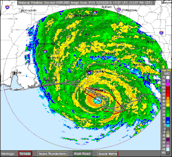
Based on post-storm analyses conducted by the National Hurricane Center synthesizing data from several observation networks, Michael made landfall as a Category 5 hurricane near Tyndall Air Force Base at 12:30 p.m. CDT (17:30 UTC) on October 10. Its maximum sustained winds were estimated to be 160 mph (260 km/h) upon moving ashore, making it the most intense hurricane landfall on record for the Florida Panhandle.[1]:18 Michael is the only tropical cyclone known to have struck the Florida Panhandle at Category 5 intensity and the first to do so anywhere along the U.S. coast since Hurricane Andrew in 1992.[47][1]:6 Three surface weather stations collected data from Michael's eyewall as it moved onshore; however, they either malfunctioned before the arrival of the storm's strongest winds or were positioned outside the radius of maximum wind, providing incomplete measurements and resulting in maximum values lower than expected from radar and aircraft reconnaissance data. The fastest 1-minute average wind measured by a surface-based anemometer was 86 mph (138 km/h) at a weather station within Tyndall Air Force Base; the same station recorded a peak wind gust of 139 mph (224 km/h). Another station on the base grounds, affixed to a tower, registered a 129 mph (208 km/h) gust before the tower toppled.[1]:5–6 Michael continued to produce hurricane-force wind gusts near its center as it moved across the Florida Panhandle into Georgia; its center traversed the Panhandle in four hours. A 102 mph (164 km/h) gust was documented in Marianna, Florida.[1]:7
The combination of Michael's storm surge and the astronomical tide submerged normally dry areas under 9–14 ft (2.7–4.3 m) of water along the coast between Tyndall Air Force Base and Port St. Joe, Florida. Waves atop the elevated water levels caused additional damage and inundation.[1]:8 Maximum inundation depths were further enhanced by St. Joseph Peninsula, which kept the storm surge elevated by preventing surge water from receding into the open gulf.[48]:1-7 Storm surge inundation decreased farther west and east of the hurricane's point of landfall; along the Big Bend inundation heights were 6–9 ft (1.8–2.7 m), and towards Tampa Bay they diminished to 2–4 ft (0.61–1.22 m). Between Pensacola and Panama City, maximum storm surge inundation was also 2–4 ft (0.61–1.22 m).[1]:9 The highest rainfall total from Michael in Florida occurred at Lynn Haven, where 11.62 in (295 mm) of rain was measured.[1]:9–10 Higher rainfall totals were concentrated in eastern Washington County and western Jackson County; locations in the path of Michael's eyewall received 6–10 in (150–250 mm) of rain while those in the hurricane's outer rainbands generally recorded 1–3 in (25–76 mm) of rain.[48]:1-11 The impacts of inland flooding were lessened by Michael's quick path through the Florida Panhandle, occurring in localized areas.[41] Power outages affected nearly 400,000 electricity customers in Florida at their greatest extent, representing about 4% of the state.[49] Five counties experienced a complete loss of electrical power.[41]
Bay County
.jpg)
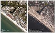
Catastrophic and widespread damage occurred in Bay County, where Michael made landfall; 45,000 structures were damaged and 1,500 were destroyed throughout the county.[1]:11 Two hospitals—Bay Medical Sacred Heart and Gulf Coast Regional Medical Center—suffered significant damage.[41] Approximately 19.5 mi (31.4 km) of the 41.2 mi (66.3 km) Bay County coastline, which includes Panama City Beach and Mexico Beach, sustained critical beach erosion.[50]:14 Sensor data and high water marks surveyed by the United States Geological Survey indicated that water inundation at Mexico Beach reached a depth of 14 ft (4.3 m) above ground level,[1]:8 classifying Michael's surge at Mexico Beach as a 1-in-280 year event.[50]:15 Mexico Beach was the community most heavily impacted by Hurricane Michael and experienced both the hurricane's maximum winds and surge;[51][52]:15 Federal Emergency Management Agency Administrator Brock Long described the city as "probably ground zero."[53] Of the 1,692 buildings in the city, 1,584 were damaged and 809 among those were destroyed.[1]:10–11 Waves augmented by the elevated waters damaged the second-stories of buildings and carried boats inland.[41][54] Along the immediate coast, the combination of surge and extreme winds whittled buildings down to piles of debris and left their concrete slab foundations exposed.[52]:15 Those that remained intact were crumpled and contorted or were eventually razed by unattended fires that began during the storm.[54][55] Beach houses were severed from their pilings and the city's public pier succumbed to the intense surf.[56] Some staircases remained standing without their associated houses.[55] Debris from various razed structures accumulated on U.S. Route 98,[52]:15 whose pavement was partially washed out by Michael.[57] The road remained closed for nearly a year before repairs completed.[58] Boats were broken in half and 33-short-ton (30 t) rail cars were toppled.[59] It was estimated that as many as 285 residents of the small town may have stayed despite mandatory evacuations.[54] Three drownings occurred in or near Mexico Beach.[1]:10–11
Significant structural damage was wrought to Tyndall Air Force Base.[60] Due to the base's location on the left side of Michael's eye, damage there was primarily due to the force of the winds rather than storm surge.[61] Every building was damaged and many were considered a complete loss by the base administration; the base's marina was also destroyed.[62][1]:10–11[52]:16 Of the damaged buildings, 484 were considered destroyed or beyond repair; $648 million was later allocated in repairs for the remaining structures.[63] Vehicles were tossed through parking lots and destroyed, and an McDonnell Douglas F-15 Eagle and General Dynamics F-16 Fighting Falcon used for display were flipped and damaged.[64][65] Most hangars, including those that housed Lockheed Martin F-22 Raptors, were fully unroofed and battered by the strong winds.[61] The 17 Raptors that remained at the base remained relatively unscathed and were brought to airworthy condition within a few days.[66] The base's power, water, and sewage systems were downed,[67] rendering the base uninhabitable.[68]:15 The flight line and drone runway was crippled.[62][64] The damage toll inflicted to installations at the base reached $3 billion.[1]:10–11 Large forests in the area were almost entirely flattened to the ground, while trees that remained standing on and around the base were completely stripped and denuded. Three-fourths of the longleaf pine trees on the base were sheared in half, equating to $14 million in harvestable timber losses.[69][70] Parts of the gymnasium of a nearby elementary school were also unroofed.[41]
.jpg)
An estimated ten to twenty thousand people were displaced by the storm in Panama City, of which one thousand remained at three area shelters.[71] The Panama City area was buffeted by gusts as high as 164 mph (264 km/h), inflicting roof damage and tearing the aluminum siding off of most homes and businesses; at least 90% of all structures and 69% of homes were damaged.[72][73][52]:16 Further damage was caused by trees falling upon roofs.[52]:16 A gas leak at an unroofed motel endangered guests who had sought shelter inside.[74] Nine people were rescued by a helicopter after their house's roof collapsed.[75] Cars, truck trailers, recreational vehicles, and trains were tossed around by the wind.[74][76] A high school's gymnasium had its roof peeled back and some of its interior walls blown apart.[77] Broken glass and snapped utility poles littered the city streets and parking lots.[78] Downed studio transmitter link towers and power outages resulted in the loss of nearly all television and radio stations in the Panama City region.[79] One collapsed tower tore a hole into the roof of the adjoining studio building.[80] Severe roof and siding damage was prevalent in Panama City Beach, where gusts reached 87 mph (140 km/h).[52]:16 At least 98% of structures in Callaway were damaged and 300 properties were tagged as beyond repair by city officials. Nearby, 85% of residential properties and 90% of businesses were damaged in Lynn Haven.[73] The roof of a church was torn away in neighboring Southport.[81] Storm surge inundation exceeded 5.3 ft (1.6 m) along the coast in the Panama City area. Local marinas and boats docked in port were almost entirely destroyed.[52]:16 One person drowned on the eastern side of the Panama City near East Bay.[1]:10
Forgotten Coast and Apalachee Bay
In addition to the Mexico Beach area, coastal communities in Franklin and Gulf counties—collectively known as the "Forgotten Coast" due to a lack of infrastructure development in recent decades—were among those hardest-hit by Michael.[52]:15 A Florida Department of Environmental Protection survey identified 2,725 structures that sustained major flood damage in Bay, Gulf, Franklin, and Wakulla counties.[48]:1-9 Over 2,000 structures sustained damage in Gulf County, with over 1,200 suffering major damage and 985 being destroyed. In Franklin County, 80 structures were destroyed.[1]:11 Michael's storm surge created two inlets along St. Joseph Peninsula, cutting off vehicle access to a 9 mi (14 km) stretch of the T.H. Stone Memorial St. Joseph Peninsula State Park and isolating 8 cabins and 119 campsites.[41][82] The onrush of water flattened the 30 ft (9.1 m) dunes that once filled the park and left the boardwalk dilapidated.[82] The main access road to Cape San Blas was shredded into asphalt sheets.[83] Stretches of U.S. Route 98 were washed out along the coast.[41] A thousand homes were destroyed by coastal flooding in Port St. Joe and every building sustained damage.[59][84] Forty homes were later demolished as their structural integrity declined. Many stores along the city's main street were flooded halfway up their first floors.[84][85] Storefronts were covered in sand piled up by the hurricane and homes and condos were displaced from their foundations.[86][84] The Port St. Joe marina was severely damaged, contributing to the 400 vessels lost in Gulf and Bay counties.[86] Boats from the marina were forced inland onto a parking lot 300 yd (270 m) from the docks.[85] The failure of 15 pumping stations hamstrung the city's ability to eliminate wastewater.[86] Power lines and crumpled amalgamations of cars lay strewn across roads.[87] Power poles and campers were knocked over in the adjacent community of Highland View.[85]
While Michael's storm surge flooded downtown Apalachicola, the city's buildings weathered the storm with generally minor damage.[88] However, the city was isolated due to the disheveled state of U.S. Route 98,[89] with parts of the road blocked by felled oak and pine trees and other parts submerged under the advancing seawater. The anemometer at Apalachicola Regional Airport registered gusts of 90 mph (140 km/h) before being blown away.[90] Sections of St. George Island were deeply inundated, and the island may have been entirely underwater during the storm. Although located farther from the storm than St. George Island, homes in Carrabelle sustained more severe damage due to their older and less-elevated construction, resulting in significant flood damage.[91] The road connecting Carrabelle and St. George Island was washed out every few hundred feet.[92] Along the coast of Franklin County from Alligator Point to Bald Point, the roofs of several homes were blown away; beach erosion also occurred throughout the extent. Four homes and an inn on Dog Island were destroyed.[93] As Michael's waves repeatedly battered Dog Island, some of the 15 ships wrecked by the 1899 Carrabelle hurricane became exposed.[94] Owing to the concave geometry of Apalachicola Bay, the 10 ft (3.0 m) storm surge produced by Michael along the coast Wakulla County was particularly damaging. There, the hurricane was considered most damaging in recent memory. Entire communities were swamped by the surge. In St. Marks, the depth of inundation reached 4–5 ft (1.2–1.5 m), with the floodwaters pressing farther inland than in prior storms. Most of the county's electricity customers lost power during Michael's passage. Fallen trees rendered roads impassable.[95]
 Mexico Beach
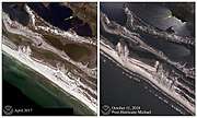 Tyndall Beach
 St. George Island
 Cape San Blas
Elsewhere in Florida
.jpg)
Strong winds from Michael penetrated inland, causing widespread damage to infrastructure and agricultural and forestry interests. Four hundred buildings were destroyed in Jackson County and major damage was inflicted upon another six hundred.[1]:11 Numerous trees and power lines were downed county-wide.[96] Some businesses in Marianna were unroofed, leading to further collapse of exterior walls.[41] The stone façades of buildings in the courthouse square were reduced to rubble. The headquarters of Jackson County's road department collapsed and shopping centers and restaurants suffered heavy damage.[96] One person died in Quincy and another in Alford to felled trees.[1]:10 Strong winds in the heavily forested regions in and around Tallahassee resulted in the widespread downing of trees, forcing the closure of over 125 roads in the city as well as an 80 mi (130 km) segment of Interstate 10 between Tallahassee and Lake Seminole. Tallahassee's sewage system also failed.[52]:16 Florida State Hospital in Chattahoochee—Florida's oldest largest psychiatric hospital—was cutoff from the outside world due to power disruptions, forcing aid to be dropped by helicopter.[97] Though localized, acute flooding resulted from Michael's rain swath. Record flooding occurred along Econfina Creek, overtopping a Florida State Road 20 bridge.[41] Near Bennett, the creek rose from below action stage to flood stage in under six hours after 5–9 in (130–230 mm) of rain fell within its watershed.[45]:51 Moderate flooding along the Chipola River near Altha damaged homes downstream and inflicted significant damage to fish camps.[41]
Sustained winds in coastal Okaloosa County, located west of Michael's landfall, met low-end tropical storm thresholds, punctuated by higher 60 mph (95 km/h) gusts. Gusts in the tropical storm range extended west to Pensacola and farther inland along the westernmost stretches of the Florida Panhandle, downing trees and power lines.[45]:53 However, the overall impacts of Michael west of Bay County were comparatively muted.[98] On the evening of October 10, 308 customers were without power in Escambia County. Isolated power outages also afflicted Okaloosa County.[99] Gusts in the Pensacola area topped out at 44 mph (71 km/h) and reached 60 mph (97 km/h) in Destin. The Navarre Causeway and the Garcon Point Bridge briefly closed as winds exceeded 39 mph (63 km/h).[100] Storm surge inundation of 2–2.5 ft (0.61–0.76 m) in the Pensacola area occurred ahead of the hurricane due to strong easterly winds, producing minor flooding. Significant beach erosion and road damage was caused by 10–15 ft (3.0–4.6 m) waves along Florida State Road 399 between Pensacola Beach and Navarre. Several piers on Choctawhatchee Bay were damaged or destroyed.[45]:53 Neighborhoods along the Santa Rosa Sound were in Pensacola Beach were flooded as the rough surf flowed over barriers.[101]
The outer fringes of Michael affected parts of the peninsular region of Florida well before its ultimate landfall. The combined wind flow from Michael's large circulation and an area of high pressure to the north generated squalls with 35–40 mph (56–64 km/h) gusts over central Florida on October 8; at the time, Michael was located near the western end of Cuba. One boat sank in Lake Monroe due to rough waters generated by the squalls, killing one person and hospitalizing another.[45]:50 Minor saltwater flooding occurred along the Atlantic and Gulf coasts of South Florida due to high tides enhanced by storm surge.[45]:52
Storm surge was responsible for most of the $100,000 damage toll along the coasts of west-central and southwestern Florida. Storm surge topped out at 4.52 ft (1.38 m) at Cedar Key. Similar surge heights occurred in Citrus County, forcing several road closures and washing away a car parked on a road ramp at Fort Island Gulf Beach. Tropical storm-force winds were also felt in isolated areas in the region. A National Ocean Service station in Cedar Key recorded a 53 mph (85 km/h) sustained wind, the highest reported in the region. Cedar Key experienced the worst effects from Michael along the west and southwestern coasts of the Florida peninsula. Two homes and two businesses experienced stormwater inundation, in addition to another four homes in nearby Yankeetown; each building sustained minor damage amounting to roughly $10,000 per building. Michael's outer rainbands spawned at least four waterspouts; one briefly moved ashore Sarasota County 3 mi (4.8 km) northwest of Siesta Key and was classified as an EF0 tornado.[45]:53
Georgia
.jpg)
Michael crossed into Georgia in Donalsonville, where significant damage to structures and trees occurred. Tropical storm force wind gusts were observed as far north as Athens and Atlanta. More than 400,000 electrical customers in Georgia were left without power. At least 127 roads throughout the state were blocked by fallen trees or debris.[102] In Albany, where wind gusts reached 74 mph (119 km/h),[103] 24,270 electrical customers lost power. Numerous trees fell on homes and roads, blocking about 100 intersections. Winds also ripped siding off of homes and shattered windows at the convention center. A tornado in Crawford County damaged seven homes.[104] An 11-year-old girl in Seminole County died after debris fell on her home.[102]
Agriculture across the state suffered tremendous losses. As of October 18, estimated damage in the agriculture industry alone reached $2.38–2.89 billion. Forestry experienced the greatest losses at $1 billion, with about 1 million acres of trees destroyed. Described as a "generational loss", pecan farms in many areas were wiped out. Farmers were still recovering from damage incurred by Hurricane Irma during the preceding year. The entire crop in Seminole County was lost and 85 percent was lost in Decatur. Initially expected to be a record harvest, a large portion of the cotton crop—worth an estimated $300–800 million—was wiped out. Four hundred and eighty million dollars' worth of vegetables were destroyed. In the poultry industry, more than 2 million chickens died due to the storm, and the loss were about $25 million.[7] The insurance claims throughout the state were about $700 million.[6]
Elsewhere
As the storm passed through North Carolina, 490,000 Duke Energy customers were left without power late on October 11. 342,000 remained without power in the state 24 hours later.[105] A tree fell on a car in Statesville, killing the driver.[106] Two others died in Marion when they crashed into a tree that had fallen across a road.[107]
.jpg)
In Virginia, four people including a firefighter were washed away by floodwaters, and another firefighter was killed in a vehicle accident on Interstate 295.[108] A sixth fatality was discovered when the body of a woman was found on October 13.[109] At least 1,200 roads were closed, and hundreds of trees were downed. Up to 600,000 people were left without power at the height of the storm.[107]
In Maryland, the remnants of Michael dropped 7 inches (180 mm) of rain over a period of a few hours in Wicomico County on October 11. Flooding from the Rockawalkin Creek damaged a portion of Maryland Route 349, forcing the road to be closed.[110] The remnants of Michael flooded homes in the Canal Woods neighborhood in Salisbury.[111]
Aftermath
.jpg)
On October 9—a day before Hurricane Michael made landfall—President Donald Trump signed an emergency declaration for Florida, which authorized the Federal Emergency Management Agency (FEMA) to coordinate disaster efforts, with Thomas McCool serving as Federal Coordinating Officer in the state. The declaration also authorized funding for 75% of the cost of emergency protective measures and the removal of storm debris in 14 Florida counties. The federal government also provided for 75% of the cost of emergency protective measures in an additional 21 counties.[112] On October 11, President Trump declared a major disaster in five counties: Bay, Franklin, Gulf, Taylor, and Wakulla. Residents in the county were able to receive grants for house repairs, temporary shelter, loans for uninsured property losses, and business loans.[113] In addition to FEMA, several private and non-profit organizations, including the DSA, PSL, and SRA. established the Hurricane Michael Relief Network which provided direct relief to residents that were affected by the disaster. [114]
Due to the storm damage in Georgia, President Trump also signed an emergency declaration for Georgia, where FEMA activity was coordinated by Manny J. Torro. The declaration authorized funding for 75% of the cost of emergency protective measures and the removal of storm debris in 31 Georgia counties, and 75% of the cost of emergency protective measures in an additional 77 counties.[115]
Florida Governor Ron DeSantis has since requested, with the storm's elevation to Category 5, the federal relief share be increased from 75% to 90%.[116] Either value awaits passage of a specific relief package being delayed in the United States House of Representatives.[117]
Retirement
On March 20, 2019, at the 41st session of the RA IV hurricane committee, the World Meteorological Organization retired the name Michael from its rotating name lists, due to the extreme damage and loss of life it caused along its track, particularly in the Florida Panhandle and southwest Georgia, and its name will never again be used for another Atlantic hurricane. It will be replaced with Milton for the 2024 season.[118]
Records
| Rank | Hurricane | Season | Damage | ||
|---|---|---|---|---|---|
| 1 | Katrina | 2005 | $125 billion | ||
| Harvey | 2017 | ||||
| 3 | Maria | 2017 | $90 billion | ||
| 4 | Irma | 2017 | $77.6 billion | ||
| 5 | Sandy | 2012 | $65 billion | ||
| 6 | Ike | 2008 | $30 billion | ||
| 7 | Andrew | 1992 | $27 billion | ||
| 8 | Michael | 2018 | $25 billion | ||
| 9 | Florence | 2018 | $24.2 billion | ||
| 10 | Ivan | 2004 | $20.5 billion | ||
| Source: National Hurricane Center[119][nb 2][120] | |||||
With top sustained winds of 160 mph (260 km/h) and a central pressure of 919 mbar (27.14 inHg) at landfall, Michael was the most intense landfalling mainland U.S. hurricane since Camille in 1969, which had a central pressure of 900 mbar (26.58 inHg), and the first landfalling Category 5 Atlantic hurricane in the U.S. since Andrew in 1992, which had 165 mph (270 km/h) winds..[121] Michael is tied with the 1928 Okeechobee hurricane for the sixth-strongest tropical cyclone by wind speed to impact the United States (including its overseas territories), and was the fourth strongest to impact the U.S. mainland.[122] Additionally, Michael was the second-most intense hurricane by pressure to make landfall in Florida, behind the 1935 Labor Day hurricane, and the third strongest by wind, behind the 1935 Labor Day hurricane and Andrew.[123]
Michael was the second-most intense hurricane to have made landfall during the month of October in the North Atlantic basin (including the Gulf of Mexico and the Caribbean Sea), behind the 1924 Cuba hurricane.[124] Michael was also the first recorded Category 4 or 5 hurricane to strike the Florida Panhandle since reliable records began in 1851.[125]
See also
- List of Category 5 Atlantic hurricanes
- List of Cuba hurricanes
- List of Florida hurricanes
- 1894 Florida Panhandle hurricane – Category 3 hurricane that made landfall near where Michael did
- Hurricane Eloise – Category 3 hurricane that impacted the Gulf Coast of Florida
- Hurricane Frederic – Category 4 hurricane that impacted the Gulf Coast, particularly Alabama
- Hurricane Opal – impacted Mexico and Central America in its early stages, before striking the Florida Panhandle as a major hurricane
- Hurricane Ivan – impacted the Gulf Coast of Alabama and the western Florida Panhandle as a Category 3 hurricane
- Hurricane Dennis – the last major hurricane to strike the Florida Panhandle before Michael
- Tropical Storm Alberto (2018)
- Tropical Storm Nestor (2019) - impacted the same area where Michael made landfall, causing only minor effects
- Climate change
Notes
- The position of Michael's Category 5 peak is not depicted in this graphic as it is an asynoptic point (i.e. not at the 6-hour intervals of all other points) occurring at 17:30 UTC October 10.
- All damage figures in this table are in nominal value in 2004 USD.
References
- John L. Beven II, Robbie Berg, and Andrew Hagan (April 19, 2019). "Tropical Cyclone Report: Hurricane Michael" (PDF). National Hurricane Center. NOAA. Retrieved April 19, 2019.CS1 maint: multiple names: authors list (link)
- "Assessing the U.S. Climate in 2018". National Centers for Environmental Information (NCEI). February 6, 2019. Retrieved February 9, 2019.
- Global Catastrophe Recap October 2018 (PDF). AON (Report). AON. November 7, 2018. Retrieved November 19, 2018.
- "While Trump Calls Climate Change a Hoax, Hurricane Michael Damaged US Fighter Jets Worth $6 Billion". Democracy Now!. October 26, 2018. Retrieved October 26, 2018.
- "Hurricane Michael insured losses near $5.53 billion". The News-Herald. The News Service of Florida. February 7, 2019. Retrieved February 8, 2019.
- Liz Fabian (October 23, 2018). "Georgia nears $700 million in Hurricane Michael insured losses as victims begin recovery". The Telegraph. Retrieved November 1, 2018.
- "Breaking down Michael's estimated $3 billion hit to Georgia agriculture". Atlanta Journal Constitution. October 18, 2018. Retrieved October 21, 2018.
- "Hurricane Michael tally at $5 billion in property damage, $1.5 billion in crop loss". Watchdog.org. January 8, 2019. Retrieved January 9, 2019.
- Stewart, Stacy R. (October 2, 2018). "NHC Graphical Tropical Weather Outlook Archive". Miami, Florida: National Hurricane Center. Retrieved October 7, 2018.
- Beven, Jack (October 6, 2018). "Potential Tropical Cyclone Fourteen Advisory Number 1". Miami, Florida: National Hurricane Center. Retrieved October 7, 2018.
- Beven, John L. (October 6, 2018). "Potential Tropical Cyclone Fourteen Discussion Number 1". Miami, Florida: National Hurricane Center. Retrieved October 6, 2018.
- Berg, Robbie (October 7, 2018). "Tropical Depression Fourteen Discussion Number 3". Miami, Florida: National Hurricane Center. Retrieved October 7, 2018.
- Brown, Daniel P. (October 7, 2018). "Tropical Storm Michael Discussion Number 4". Miami, Florida: National Hurricane Center. Retrieved October 7, 2018.
- Berg, Robbie (October 8, 2018). "Tropical Storm Michael Discussion Number 6". Miami, Florida: National Hurricane Center. Retrieved October 8, 2018.
- "Atlantic hurricane best track (HURDAT version 2)" (Database). United States National Hurricane Center. December 12, 2019.
- National Hurricane Center; Hurricane Research Division; Atlantic Oceanographic and Meteorological Laboratory (May 2018). "Continental United States Hurricanes (Detailed Description)". AOML. Miami, Florida: United States National Oceanic and Atmospheric Administration's Office of Oceanic & Atmospheric Research. Retrieved April 24, 2020.
- John L. Beven II; Robbie Berg; Andrew Hagen (April 19, 2019). Hurricane Michael (PDF) (Report). National Hurricane Center. Retrieved April 19, 2019.
- Stewart, Stacy (October 8, 2018). "Hurricane Michael Discussion Number 10". Miami, Florida: National Hurricane Center. Retrieved October 9, 2018.
- Feltgen, Dennis (April 19, 2019). "Hurricane Michael upgraded to a Category 5 at time of U.S. landfall". National Oceanic and Atmospheric Administration. Retrieved April 19, 2019.
- Brown, Daniel P. (October 11, 2018). "Tropical Storm Michael Discussion Number 21". Miami, Florida: National Hurricane Center. Retrieved October 12, 2018.
- "Europe Weather Analysis on 2018-10-14". Free University of Berlin. October 14, 2018. Retrieved October 16, 2018.
- "Europe Weather Analysis on 2018-10-15". Free University of Berlin. October 15, 2018. Retrieved October 16, 2018.
- Daniel Chaitin (October 16, 2018). "When Michael met Leslie: Ex-hurricanes dance, merge over Spain". Washington Examiner. Retrieved June 3, 2019.
- "Europe Weather Analysis on 2018-10-16". Free University of Berlin. October 16, 2018. Retrieved October 16, 2018.
- "Europe Weather Analysis on 2018-10-17". Free University of Berlin. October 17, 2018. Retrieved October 20, 2018.
- "Huracán Michael deja daños significativos en Cuba" (in Spanish). Conexión Capital. October 10, 2018. Retrieved October 10, 2018.
- Brackett, Ron (October 7, 2018). "Florida Governor to Declare State of Emergency Ahead of Potential Hurricane Threat". The Weather Channel. Retrieved October 7, 2018.
- "Gov. Scott: Federal Pre-Landfall Emergency Declaration Signed by the President". Florida Division of Emergency Management. October 9, 2018. Retrieved October 10, 2018.
- Roberson, Amber (October 8, 2018). "Hurricane Michael: First Florida evacuations ordered in Gulf County, others in panhandle". Tallahassee Democrat. Retrieved October 8, 2018.
- "FSU closing Tuesday-Friday due to Hurricane Michael". WPTV. October 8, 2018. Retrieved October 8, 2018.
- Strigus, Eric (October 9, 2018). "South Georgia college campuses closing in preparation of Hurricane Michael". The Atlanta Journal-Constitution. Retrieved October 9, 2018.
- Mines, Adam (October 9, 2018). "Atlanta Motor Speedway opening camping facilities for Hurricane Michael evacuees". Macon, GA: WGXA. Retrieved August 30, 2019.
- "Hurricane Michael - LIVE: Tropical cyclone on path for Florida hits Category 4 with 130mph winds". The Independent. Retrieved October 10, 2018.
- "Hurricane Michael". Direct Relief. October 10, 2018. Retrieved May 24, 2019.
- "Hurricane Michael death toll continues to rise". WJHG-TV. January 11, 2019. Retrieved February 2, 2019.
- "Tres muertos y más de 1900 viviendas afectadas por lluvias". Confidencial (in Spanish). October 6, 2018. Retrieved October 7, 2018.
- "Sube a ocho el número de muertos por las lluvias en Honduras". El Nuevo Diario (in Spanish). October 10, 2018. Retrieved October 12, 2018.
- "Al menos 9 muertos y miles de afectados por un temporal en Centroamérica". La Vanguardia (in Spanish). October 7, 2018. Retrieved October 7, 2018.
- Morales, Benjamín (October 8, 2018). "Michael se aleja de Cuba tras dejar daños en el occidente". El Nuevo Día (in Spanish). Retrieved October 10, 2018.
- "Hurricane Michael leaves 1.2 million in the dark from Florida to Virginia". Washington Examiner. October 12, 2018. Retrieved October 15, 2018.
- "Catastrophic Hurricane Michael Strikes Florida Panhandle October 10, 2018". Hurricane Michael 2018. Tallahassee, Florida: National Weather Service Tallahassee, Florida. Retrieved March 12, 2020.
- Hurricane Michael: Field Assessment Team 1 (FAT-1) Early Access Reconnaissance Report (EARR) (PDF) (Report). Tallahasee, Florida: Structural Extreme Event Reconnaissance Network. October 25, 2018. Retrieved March 13, 2020 – via National Weather Service Tallhassee, Florida.
- "Hurricane Michael Storm Damage Assessment" (PDF). Florida Department of Highway Safety and Motor Vehicles. October 2018. Retrieved March 14, 2020.
- Initial Value Estimate of Altered, Damaged or Destroyed Timber in Florida (PDF) (Report). Tallahassee, Florida: Florida Department of Agriculture and Consumer Services. October 19, 2018. Retrieved March 12, 2020.
- Hinson, Stuart, ed. (October 2018). "Storm Data: October 2018" (PDF). Storm Data. Asheville, North Carolina: National Centers for Environmental Information. 60 (10). ISSN 0039-1972. Archived from the original (PDF) on March 12, 2020. Retrieved March 12, 2020.
- Alvarez, Sergio (October 30, 2018). "Hurricane Michael's Damage to Florida Agriculture" (PDF). Tallahasee, Florida: Florida Department of Agriculture and Consumer Services. Retrieved March 14, 2020.
- Livingston, Ian (April 19, 2019). "Hurricane Center reclassifies Michael to Category 5, the first such storm to make landfall since 1992". The Washington Post. Washington, D.C.: The Washington Post. Retrieved March 11, 2020. (subscription required)
- Hurricane Michael in Florida (PDF) (Mtigiation Assessment Team Report). Washington, D.C.: Federal Emergency Management Agency. February 2020. Retrieved March 14, 2020.
- "Hurricane Michael caused 1.7 million electricity outages in the Southeast United States". Today in Energy. Washington, D.C.: U.S. Energy Information Administration. October 22, 2018. Retrieved March 11, 2020.
- "Hurricane Michael Post-Storm Beach Conditions and Coastal Impact Report" (PDF). Tallahasee, Florida: Florida Department of Environmental Protection. April 2019. Retrieved March 13, 2020.
- Achenbach, Joel; Begos, Kevin; Samenow, Jason (November 16, 2018). "Hurricane Michael is looking even more violent on closer scrutiny". NWFDailyNews.com. Gannett Co., Inc. The Washington Post. Retrieved March 14, 2020.
- "Hurricane Michael Event Recap Report" (PDF). Aon. March 2019. Retrieved March 13, 2020.
- Brackett, Ron (October 12, 2018). "Hurricane Michael Update: Bodies Found on Florida's Mexico Beach; Toll Had Already Reached 13". The Weather Channel. Atlanta, Georgia: TWC Product and Technology LLC. Retrieved March 14, 2020.
- "Mexico Beach, FL is unrecognizable after Hurricane Michael". WKYC-TV. Cleveland, Ohio: WKYC-TV. Associated Press. October 11, 2018. Retrieved March 14, 2020.
- Sampson, Zachary T. (October 11, 2018). "Ground zero: See the damage Hurricane Michael inflicted on Mexico Beach". Tampa Bay Times. Tampa, Florida: Tampa Bay Times. Retrieved March 14, 2020.
- Sullivan, Patricia; Wax-Thibodeaux, Emily; Gowen, Annie (October 12, 2018). "'It's all gone': Tiny Florida beach town nearly swept away by Hurricane Michael". The Washington Post. Washington, D.C.: The Washington Post. Retrieved March 14, 2020. (subscription required)
- Sampson, Zachary T. (October 12, 2018). "'We're broken here.' Mexico Beach reels in the aftermath of Hurricane Michael". Tampa Bay Times. Tampa, Florida: Tampa Bay Times. Retrieved March 14, 2020.
- Breaux, Collin (October 1, 2019). "U.S. 98 open again in Mexico Beach following Hurricane Michael damage repairs". Panama City News Herald. Panama City, Florida: Gannett Co., Inc. Retrieved March 14, 2020.
- O'Donoghue, Gary (October 13, 2018). "Hurricane Michael flattens beach town like 'mother of all bombs'". BBC News. British Broadcasting Corporation. Retrieved March 14, 2020.
- Vanden Brook, Tom (October 11, 2018). "Michael blasted Tyndall Air Force Base in Florida — a key to homeland security". USA Today. Gannett Satellite Information Network, LLC. Retrieved March 14, 2020.
- Achenbach, Joel; Begos, Kevin; Lamothe, Dan (October 23, 2018). "Hurricane Michael: Tyndall Air Force Base was in the eye of the storm, and almost every structure was damaged". The Washington Post. Washington, D.C.: The Washington Post. Retrieved March 14, 2020.
- Martinez, Luis (October 12, 2018). "'Complete devastation' at Tyndall AFB after direct hit from Michael". ABC News. ABC News Internet Ventures. Retrieved March 14, 2020.
- Reeves, Magen M. (October 10, 2019). "Tyndall one year after Hurricane Michael". Tyndall Air Force Base. Tyndall Air Force Base, Florida: United States Air Force. Retrieved March 14, 2020.
- "Tyndall Air Force Base Sustains 'Catastrophic' Damage". US News. U.S. News & World Report L.P. Associated Press. October 12, 2018. Retrieved March 14, 2020.
- Everstine, Brian W. (November 2, 2018). "For Many, Rebuilding Tyndall is Personal". Air Force Magazine. Air Force Association. Retrieved March 14, 2020.
- Mizokami, Kyle (November 6, 2018). "Hurricane-Battered F-22s Are Now Flying Out of Michael's Aftermath". Popular Mechanics. Hearst Magazine Media, Inc. Retrieved March 14, 2020.
- Lasin, Julius (October 12, 2018). "Tyndall AFB: Florida air force base suffers major Hurricane Michael damage, see the video". Pensacola News Journal. Pensacola, Florida: PNJ.com. USA Today Network. Retrieved March 14, 2020.
- Hurricane Michael Preliminary Virtual Assessment Team (P-VAT) Report (PDF) (Report). Structural Extreme Event Reconnaissance Network. October 15, 2018. Retrieved March 14, 2020 – via National Weather Service Tallahassee, Floriday.
- Chapman, Dan (June 7, 2019). "Hurricane Michael allows Service, Air Force to increase longleaf pine restoration". Atlanta, Georgia: U.S. Fish and Wildlife Service. Retrieved March 14, 2020.
- Reeves, Magen M. (January 16, 2020). "Deforestation on Tyndall AFB leads to ecosystem restoration". Tyndall Air Force Base, Florida: United States Air Force. Retrieved March 14, 2020.
- Thrush, Glenn (October 29, 2018). "A Florida City, Hit Hard by Hurricane Michael, Seeks More Housing Aid". The New York Times. New York, New York: The New York Times Company. Retrieved March 14, 2020. (subscription required)
- Neale, Rick (May 23, 2019). "Mexico Beach, Florida's Panhandle still reeling 7 months after Hurricane Michael struck". Florida Today. FloridaToday.com. USA Today. Retrieved March 14, 2020.
- Crowder, Valerie (October 11, 2019). "Hurricane Michael A Year Later: Panama City Code Enforcement Starting Crackdown On Property Neglect". WLRN. Miami, Florida: WLRN. Retrieved March 14, 2020.
- Braun, Michael (October 10, 2018). "In a harrowing two hours, Hurricane Michael devastates Panama City". Florida Today. FloridaToday.com. Retrieved March 14, 2020.
- "At least six dead as storm blows through Carolinas – as it happened". The Guardian. Guardian News & Media Limited. February 12, 2019. Retrieved March 14, 2020.
- Fausset, Richard; Blinder, Alan; Mazzei, Patricia (October 10, 2018). "Hurricane Michael Leaves Trail of Destruction as It Slams Florida's Panhandle". The New York Times. New York, New York: The New York Times. Retrieved March 14, 2020. (subscription required)
- Detman, Gary (October 11, 2018). "Hurricane Michael peels roof from high school gym in Panama City". CBS 12. West Palm Beach, Florida: CBS 12. Retrieved March 14, 2020.
- Hughes, Trevor; Neale, Rick; Robinson, Kevin (October 11, 2018). "Hurricane Michael cripples Panama City with heartbreaking devastation". Pensacola News Journal. Pensacola, Florida: PNJ.com. USA Today. Retrieved March 14, 2020.
- Venta, Lance (October 10, 2018). "Hurricane Michael Takes Panama City Off The Air". RadioInsight. RadioInsight.com. Retrieved March 14, 2020.
- Venta, Lance (October 13, 2018). "Powell Broadcasting To Cease Panama City Operations". RadioInsight. RadioInsight.com. Retrieved March 14, 2020.
- Ortiz, Erik; Abdelkader, Rima; Gostanian, Ali; Helsel, Phil (October 11, 2018). "Panama City bears brunt of Hurricane Michael's destructive force". NBC News. NBC Universal. Retrieved March 14, 2020.
- Etters, Karl (January 18, 2019). "BREACHED BEACH: Battered St. Joseph Peninsula State Park reopening after Hurricane Michael". Tallahasee Democrat. Tallhassee, Florida: Tallahassee.com. Retrieved March 14, 2020.
- Solomon, Josh (October 15, 2018). "In Cape San Blas, a wary walk to find out what Michael left behind". Tampa Bay Times. Tampa, Florida: Tampa Bay Times. Retrieved March 14, 2020.
- Dove, Patrick (October 13, 2018). "Residents of Port St. Joe among those hardest hit by Hurricane Michael". TCPalm. Port St. Lucie, Florida: Gannett. Treasure Coast News. Retrieved March 14, 2020.
- Adams, Alicia (October 20, 2018). "HURRICANE MICHAEL: Port St. Joe struggles for normalcy". Northwest Florida Daily News. Fort Walton Beach, Florida: Gannett Co., Inc. Retrieved March 14, 2020.
- Schweers, Tallahassee (February 24, 2019). "THE TOURISM TEST: 'It'll be rough' but Port St. Joe sees path forward after Hurricane Michael". Tallahasee Democrat. Tallahasee, Florida: Tallahasee.com. Retrieved March 14, 2020.
- "In hardest-hit towns, Hurricane Michael leaves nothing unscathed". CBS This Morning. CBS Interactive Inc. CBS News. October 11, 2018. Retrieved March 14, 2020.
- Mazzei, Patricia (October 12, 2018). "For a Struggling Oyster Town, Hurricane Michael May Be One Misery Too Many". The New York Times. New York, New York: The New York Times. Retrieved March 14, 2020. (subscription required)
- Allen, Greg (October 13, 2018). "Michael Recovery: Apalachicola, Fla., Begins To Rebuild". National Public Radio. NPR. Retrieved March 14, 2020.
- Begos, Kevin; Berman, Mark; Lazo, Luz; Achenbach, Joel (October 10, 2018). "'We're kind of getting crushed': Record-breaking Hurricane Michael slams Florida". The Washington Post. Washington, D.C.: The Washington Post. Retrieved March 14, 2020. (subscription required)
- "Hurricane Michael Damage Assessment: Carrabelle and St. George Island". Woodbury, New Jersey: Vanguard. October 23, 2018. Retrieved March 14, 2020.
- "Hurricane Michael aftermath in Franklin County". WTXL-TV. Tallahassee, Florida: Scripps Media, Inc. September 30, 2019. Retrieved March 14, 2020.
- Adlerstein, David (October 25, 2018). "Apalachicola destruction: 'We're going to see a huge drop in the tax rolls'". Northwest Florida Daily News. Fort Walton Beach, Florida: Gannett Co., Inc. Retrieved March 14, 2020.
- Etters, Karl (October 20, 2018). "Hurricane Michael unearthed 19th century shipwrecks in Florida". USA Today. USA Today. Tallahassee Democrat. Retrieved March 14, 2020.
- Burlew, Jeff (October 11, 2018). "Michael hit Wakulla County harder than any other hurricane in memory". Tallahasse Democrat. Tallahassee, Florida: Tallahassee.com. Retrieved March 14, 2020.
- Burlew, Jeff (January 27, 2019). "Hurricane Michael: 'Like a bomb went off' in Jackson County, Marianna". Tallahassee Democrat. Tallahassee, Florida: Tallahassee.com. Retrieved March 14, 2020.
- "Hurricane Michael leaves Florida's main psych hospital cut off. Helicopters drop aid". Miami Herald. Miami, Florida: Miami Herald Media Company. Miami Herald, Times Tallahassee Bureau. October 11, 2018. Retrieved March 14, 2020.
- Victoria, Wendy (October 19, 2018). "Western counties escape the brunt of Michael". NWFDailyNews.com. Fort Walton Beach, Florida: Gannett Co., Inc. Retrieved March 14, 2020.
- McLaughlin, Tom (October 10, 2018). "OKALOOSA UPDATE: County may be spared hurricane-force winds". Northwest Florida Daily News. Pensacola, Florida: Gannett Co., Inc. Retrieved October 10, 2018.
- "Hurricane Michael spares Pensacola area from its wrath". Pensacola News Journal. Pensacola, Florida: PNJ.com. October 10, 2018. Retrieved March 13, 2020.
- Pippin, Cory (October 10, 2018). "Santa Rosa Sound rises during Hurricane Michael, floods entire neighborhoods". WEAR-TV. Pensacola, Florida: Sinclair Broadcast Group. WPMI-TV. Retrieved March 13, 2020.
- Northam, Mitchell; Godwin, Becca J. G.; Habersham, Raisa (October 11, 2018). "Hurricane Michael in Georgia: Damage by the numbers". The Atlanta Journal Constitution. Retrieved October 12, 2018.
- Jessica Fieux (October 18, 2018). Post Tropical Cyclone Report Hurricane Michael (Report). Archived from the original on October 21, 2018. Retrieved October 21, 2018.
- Brasch, Ben; Edwards, Johnny; Boone, Christian (October 11, 2018). "Hurricane Michael: Damage in Georgia is 'phenomenal'". The Atlanta Journal Constitution. Retrieved October 12, 2018.
- Henderson, Bruce (October 12, 2018). "More than 400,000 in Carolinas still without power after Tropical Storm Michael". The Charlotte Observer. Retrieved October 12, 2018.
- "1st death reported in NC from Michael". CBS 17 News. October 11, 2018. Retrieved October 11, 2018.
- Wright, Pam (October 13, 2018). "Michael Death Toll Climbs to 18; Search Continues for Missing". The Weather Channel. Retrieved October 14, 2018.
- Hedgpeth, Dana. "Five people are dead, 1,200 roads closed and half-a-million people are without power after Michael ravages Virginia". The Washington Post (October 12, 2018). Retrieved October 12, 2018.
- "Death toll from TS Michael up to 6 in Virginia". WHSV-TV3. October 13, 2018. Retrieved October 14, 2018.
- Tyszko, Erin (October 15, 2018). "Nanticoke Road Closure in Wicomico County". Salisbury, MD: WBOC-TV. Retrieved October 26, 2018.
- "Major Flooding in Canal Woods After Tropical Storm Michael". Salisbury, MD: WBOC-TV. October 12, 2018. Retrieved October 26, 2018.
- "President Donald J. Trump Signs Emergency Declaration for Florida". FEMA. October 9, 2018. Retrieved October 12, 2018.
- "President Donald J. Trump Approves Major Disaster Declaration for Florida". FEMA. October 11, 2018. Retrieved October 12, 2018.
- Arria, Michael. "Left-Wing Disaster Relief Efforts Spread Goodwill for Socialism". Truthout. Retrieved July 23, 2019.
- "President Donald J. Trump Signs Emergency Declaration for Georgia". FEMA. October 11, 2018. Retrieved October 12, 2018.
- https://www.newsherald.com/news/20190422/desantis-asks-trump-to-increase-hurricane-michael-cleanup-money
- https://www.graydc.com/content/news/Florida-lawmaker-reflects-on-six-months-since-Hurricane-Michaels-curse-508395081.html
- "Florence and Michael retired by the World Meteorological Organization | National Oceanic and Atmospheric Administration". www.noaa.gov. Retrieved March 20, 2019.
- Costliest U.S. tropical cyclones tables update (PDF) (Report). United States National Hurricane Center. January 12, 2018. Archived (PDF) from the original on January 27, 2018. Retrieved January 12, 2018.
- "Assessing the U.S. Climate in 2018". National Centers for Environmental Information (NCEI). February 6, 2019. Retrieved February 9, 2019.
- "Hurricane Michael devastates Mexico Beach, Florida, in historic Category 4 landfall". Sun-Sentinel. October 10, 2018. Retrieved October 10, 2018.
- Klotzbach, Philip [@philklotzbach] (October 10, 2018). "Table of 10 strongest continental US landfalling #hurricanes on record as ranked by maximum sustained wind. Michael ranks fourth with sustained winds of 135 knots (155 mph) at landfall" (Tweet). Retrieved October 10, 2018 – via Twitter.
- Klotzbach, Philip (October 11, 2018). "Michael made history as one of the top four strongest hurricanes to strike the United States". The Washington Post. Retrieved October 11, 2018.
- Uhlhorn, Eric; Lorsolo, Sylvie (October 10, 2018). "Why Hurricane Michael's Landfall Is Historic". Air-Worldwide. Retrieved October 10, 2018.
- Klotzbach, Philip [@philklotzbach] (October 10, 2018). "Hurricane Michael has made landfall with max sustained winds of 155 mph - the first Category 5 hurricane to make landfall in the Florida Panhandle on record" (Tweet). Retrieved October 10, 2018 – via Twitter.
External links
| Wikimedia Commons has media related to Hurricane Michael (2018). |
- The National Hurricane Center's advisory archive on Hurricane Michael
- EMSR322: Hurricane Michael over the coast of Florida, Alabama and Georgia (delineation maps) – Copernicus Emergency Management Service
| 1920s |
|
|---|---|
| 1930s |
|
| 1950s |
|
| 1960s | |
| 1970s | |
| 1980s | |
| 1990s | |
| 2000s | |
| 2010s | |
| |
Tropical cyclones of the 2018 Atlantic hurricane season | ||
|---|---|---|
Timeline | ||
 | ||
| ||
Retired Atlantic hurricane names | |
|---|---|
| 1950s | |
| 1960s | |
| 1970s | |
| 1980s | |
| 1990s | |
| 2000s | |
| 2010s | |
| |
Tallahassee (capital) | ||
| Topics |
|  Seal of Florida |
| History |
| |
| Geography |
| |
| Major hurricanes |
| |
| Society | ||
| Regions |
| |
| Metro areas |
| |
| Largest cities |
| |
| Counties |
| |