Half Dome
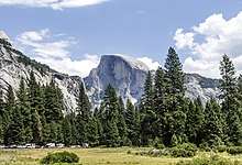
Half Dome is a granite dome at the eastern end of Yosemite Valley in Yosemite National Park, California. It is a well-known rock formation in the park, named for its distinct shape. One side is a sheer face while the other three sides are smooth and round, making it appear like a dome cut in half.[3] The granite crest rises more than 4,737 ft (1,444 m) above the valley floor.
| Half Dome | |
|---|---|
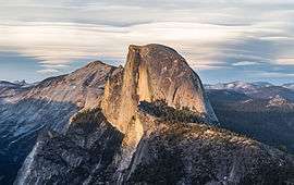 Sunset over Half Dome from Glacier Point | |
| Highest point | |
| Elevation | 8844+ ft (2695+ m) NAVD 88[1] |
| Prominence | 1,360 ft (410 m) [1] |
| Parent peak | Clouds Rest[1] |
| Coordinates | 37°44′46″N 119°31′59″W [2] |
| Geography | |
 Half Dome Mariposa County, California, US | |
| Parent range | Sierra Nevada |
| Topo map | USGS Half Dome |
| Geology | |
| Age of rock | Cretaceous, 93 Myr |
| Mountain type | Granite dome |
| Climbing | |
| First ascent | 1875 by George G. Anderson |
| Easiest route | Cable route |
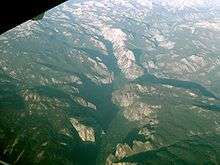
Geology
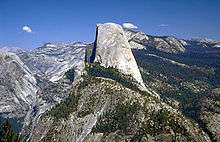
The impression from the valley floor that this is a round dome that has lost its northwest half, is just an illusion. From Washburn Point, Half Dome can be seen as a thin ridge of rock, an arête, that is oriented northeast-southwest, with its southeast side almost as steep as its northwest side except for the very top. Although the trend of this ridge, as well as that of Tenaya Canyon, is probably controlled by master joints, 80 percent of the northwest "half" of the original dome may well still be there.
Ascents

As late as the 1870s, Half Dome was described as "perfectly inaccessible" by Josiah Whitney of the California Geological Survey.[4] The summit was finally reached by George G. Anderson in October 1875, via a route constructed by drilling and placing iron eyebolts into the smooth granite.[5]
Today, Half Dome may be ascended in several different ways. Thousands of hikers reach the top each year by following an 8.5 mi (13.7 km) trail from the valley floor. After a rigorous 2 mi (3.2 km) approach, including several hundred feet of granite stairs, the final pitch up the peak's steep but somewhat rounded east face is ascended with the aid of a pair of post-mounted braided steel cables originally constructed close to the Anderson route in 1919.
Alternatively, over a dozen rock climbing routes lead from the valley up Half Dome's vertical northwest face. The first technical ascent was in 1957 via a route pioneered by Royal Robbins, Mike Sherrick, and Jerry Gallwas, today known as the Regular Northwest Face. Their five-day epic was the first Grade VI climb in the United States.[6] Their route has now been free climbed several times in a few hours' time. Other technical routes ascend the south face and the west shoulder.
Hiking the Cable Route
The Half Dome Cable Route hike runs from the valley floor to the top of the dome in 8.2 mi (13 km) (via the Mist Trail), with 4,800 ft (1,460 m) of elevation gain. The length and difficulty of the trail used to keep it less crowded than other park trails, but in recent years the trail traffic has grown to as many as 800 people a day.[7] The hike can be done from the valley floor in a single long day, but many people break it up by camping overnight in Little Yosemite Valley. The trail climbs past Vernal and Nevada Falls, then continues into Little Yosemite Valley, then north to the base of the northeast ridge of Half Dome itself.
The final 400 ft (120 m) ascent is steeply up the rock between two steel cables used as handholds.[8] The cables are fixed with bolts in the rock and raised onto a series of metal poles in late May (the poles do not anchor the cables). The cables are taken down from the poles for the winter in early October, but they are still fixed to the rock surface and can be used. The National Park Service recommends against climbing the route when the cables are down or when the surface of the rock is wet and slippery.[8] The Cable Route is rated class 3, while the same face away from the cables is rated class 5.[9]
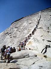
The Cable Route can be crowded. In past years, as many as 1,000 hikers per day have climbed the dome on a summer weekend, and about 50,000 hikers climb it every year.[10][11]
Since 2011, all hikers who intend to ascend the Cable Route must now obtain permits before entering the park.[12] Permits are checked by a ranger on the trail, and no hikers without permits are allowed to hike beyond the base of the sub-dome or to the bottom of the cables. Hikers caught bypassing the rangers to visit either the sub-dome or main dome without a permit face fines of up to $5,000 and/or 6 months in jail.[13]
Backpackers with an appropriate wilderness permit can receive a Half Dome permit when they pick up their wilderness permit with no additional reservation required. Rock climbers who reach the top of Half Dome without entering the subdome area can descend on the Half Dome Trail without a permit.[12]
The top of Half Dome is a large, flat area where climbers can relax and enjoy their accomplishment. The summit offers views of the surrounding areas, including Little Yosemite Valley and the Valley Floor. A notable location to one side of Half Dome is the "Diving Board", where Ansel Adams took his photograph "Monolith, The Face of Half Dome" on April 10, 1927. Often confused with "the Visor," a small overhanging ledge at the summit, the Diving Board is on the shoulder of Half Dome.[14]
From 1919 when the cables were erected through 2011, there have been seven fatal falls from the cables.[10][11][15] The latest fatality occurred on September 5, 2019.[16]
Lightning strikes can be a risk while on or near the summit. On July 27, 1985, five hikers were struck by lightning, resulting in two fatalities.[17]
The Cable Route was added to the National Register of Historic Places in 2012.[18]
Notable ascents
- 1875 George G. Anderson via drilled spikes on the east slope.[5]
- 1946 Salathe Route on southwest face (IV 5.7 A3), FA by John Salathe and Anton Nelson[19]
- 1957 Northwest Face (VI 5.8 A3), FA by Royal Robbins, Jerry Gallwas and Mike Sherrick. First Grade VI in North America.[20]
- 1963 Direct Northwest Face (VI 5.9 A5), FA by Royal Robbins and Dick McCracken[21]
- 1969 Tis-sa-ack (VI 5.9 A4), FA by Royal Robbins and Don Peterson.[21]
- 1973 First "clean ascent" of NW face by Dennis Hennek, Doug Robinson, and Galen Rowell, Hennek is on the cover of June 1974 National Geographic leading a nut protected traverse see Super Topo too
- 1987 The Big Chill (VI 5.9 A4), FA by Jim Bridwell, Peter Mayfield, Sean Plunkett and Steve Bosque[22]
- 1989 Shadows (VI 5.10 A5), FA by Jim Bridwell, Charles Row, Cito Kirkpatrick, William Westbay[23]
- 1989 Kali Yuga (VI 5.10 A4+), FA by John Middendorf, Walt Shipley[24]
- 1997 Blue Shift (VI 5.11c a4) FA by Jay Smith and Karl McConachie.[25]
Notable free climbs
- 1964 Salathe Route (5.10), FFA by Frank Sacherer, Bob Kamps & Andy Lichtman[19]
- 1965 Snake Dike (5.7), FFA by Eric Beck, Jim Bridwell and Chris Fredericks[26]
- 1976 Regular Northwest Face, Higbee variation (VI 5.12) by Art Higbee and Jim Erickson.[27]
- 1985 The Autobahn (5.11+/5.12a) by John Middendorf and Charles Cole.[28]
In culture
Half Dome was originally called "Tis-sa-ack", meaning Cleft Rock in the language of the local Ahwahnechee people. Tis-sa-ack is also the name of the fourth route on the formation, ascended by Royal Robbins and Don Peterson over eight days in October 1969. Tis-sa-ack is the name of a mother from a native legend. The face seen in Half Dome is supposed to be hers.[30] Tis-sa-ack is the name of a Mono Lake Paiute Indian girl in the Yosemite Native American legend. John Muir referred to the peak as "Tissiack".[31]
Others say Ahwahneechee Native Americans named Half Dome “Face of a Young Woman Stained with Tears” ("Tis-se’-yak") because of the colonies of brown-black lichens that form dark vertical drip-like stripes along drainage tracks in the rock faces.[32][33][34]
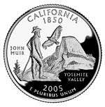
In 1988, Half Dome was featured on a 25 cent United States postage stamp. An image of Half Dome, along with John Muir and the California condor, appears on the California State Quarter, released in January 2005.
The outdoor clothing company The North Face designed its logo from a stylised drawing of Half Dome.

See also
- El Capitan
- Quarter Domes
- Sentinel Dome
- Yosemite National Park
References
- "Big Dome, California". Peakbagger.com. Retrieved 2014-01-14.
- "Half Dome". Geographic Names Information System. United States Geological Survey. Retrieved 2012-03-30.
- "USGS FAQs - Recreation - Half Dome, the massive rock monument in Yosemite National Park". www.usgs.gov. Archived from the original on 2016-02-15. Retrieved 2016-02-11.
- Jones, Chris (1976). Climbing in North America. Berkeley, California: American Alpine Club / University of California Press. p. 26. ISBN 0-520-02976-3.
- Jones, Chris. Climbing in North America. p. 27. ISBN 0-520-02976-3.
- Jones, Chris. Climbing in North America. pp. 207–211. ISBN 0-520-02976-3.
- "Half Dome Permits". Yosemite National Park. U.S. National Park Service.
- "Half Dome Day Hike". Yosemite National Park. National Park Service. Retrieved 2007-08-12.
- Secor, R.J. (1999). The High Sierra: Peaks, Passes, and Trails (2nd ed.). The Mountaineers. p. 391. ISBN 0-89886-313-9.
- "Death of Sunnyvale hiker on Half Dome called unusual". San Jose Mercury News. 2007-06-19.
- "Hiker falls to death from Yosemite's Half Dome".
- "Yosemite National Park: Half Dome Permits". National Park Service. Retrieved 2011-08-20.
- "Yosemite will require permits for Half Dome hikes, starting in May". LA Times. February 1, 2010. Retrieved 14 December 2010.
- "NPS: Ansel Adams in Yosemite National Park".
- Ghiglieri, Michael P.; Farabee, Charles R. "Butch", Jr. (2007). Off the Wall: Death in Yosemite. Flagstaff: Puma Press. pp. 184–200. ISBN 0-9700973-7-9.CS1 maint: multiple names: authors list (link)
- Vigdor, Neil (September 7, 2019). "Hiker Killed in 500-Foot Fall While Climbing Half Dome at Yosemite". The New York Times. The New York Times.
- "Lightning at Yosemite's Half Dome Kills 2 Climbers; 3 Hurt". Los Angeles Times. July 29, 1985.
- "Weekly List of Actions Taken on Properties: 8/27/12 Through 8/31/12". National Park Service. September 7, 2012. Retrieved September 19, 2013.
- Roper, Steve (1971). A Climber's Guide to Yosemite Valley. San Francisco, USA: Sierra Club Books. p. 178. ISBN 9780871560483.
- Roper, Steve (1971). A Climber's Guide to Yosemite Valley. San Francisco, USA: Sierra Club Books. pp. 174–176. ISBN 9780871560483.
- Roper, Steve (1971). A Climber's Guide to Yosemite Valley. San Francisco, USA: Sierra Club Books. p. 176. ISBN 9780871560483.
- Reid, Don (1993). Yosemite Climbs, Big Walls. Evergreen, CO, USA: Chockstone Press. p. 205. ISBN 0-934641-54-4.
- Bridwell, Jim (1991). "Shadows - Half Dome". American Alpine Journal. New York, NY USA: American Alpine Club. 33 (65): 118–123. ISBN 0-930410-46-7.
- Middendorf, John (1991). "Kaliyuga". American Alpine Journal. New York, NY USA: American Alpine Club. 33 (65): 171–172. ISBN 0-930410-46-7.
- Smith, Jay (1998). "Half Dome, Blue Shift". American Alpine Journal. New York, NY USA: American Alpine Club. 40 (72): 188. ISBN 0-930410-78-5.
- Roper, Steve (1971). A Climber's Guide to Yosemite Valley. San Francisco, USA: Sierra Club Books. p. 179. ISBN 9780871560483.
- Reid, Don (1993). Yosemite Climbs, Big Walls. Evergreen, CO, USA: Chockstone Press. p. 204. ISBN 0-934641-54-4.
- Don Reid (1986). "Climbs and Expeditions". Retrieved 15 August 2019.
- Erik Lambert (September 9, 2008). "Updated: Honnold Free Solos Half Dome 5.12". Retrieved 15 April 2011.
- Wilson, Herbert Earl (1922). "Legend of Tis-sa-sack". The Lore and Lure of Yosemite.
- Muir, John (1918). "A Geologist's Winter Walk". Steep Trails. Boston: Houghton-Mifflin. ISBN 0-87156-535-8.
I have gazed on Tissiack a thousand times — in days of solemn storms, and when her form shone divine with the jewelry of winter, or was veiled in living clouds; and I have heard her voice of winds, and snowy, tuneful waters when floods were falling.
- My Yosemite: A Guide for Young Adventurers, Mike Graf
- Spirit Of Yosemite, BackCountryPictures.com
- Lichens in relation to management issues in the Sierra Nevada national parks, McCune, B., J. Grenon, and E. Martin, L. Mutch, Sierra Nevada Network, Cooperative agreement CA9088A0008. Oregon State University, Corvallis, Oregon, and Sequoia and Kings Canyon National Parks, Three Rivers, California,
External links
| Wikimedia Commons has media related to: |
- Half Dome Day Hike on the NPS website
- Geologic Story of Yosemite National Park by N. King Huber, USGS (adapted PD source)
- "Half Dome". SummitPost.org.
- Daily updating time-lapse movies of Half Dome
- Monolith, The Face of Half Dome, Ansel Adams
- Moon and Half Dome, Ansel Adams
| Attractions |
| |||||
|---|---|---|---|---|---|---|
| People |
| |||||
| Lodging & camping |
| |||||
| Natural disasters |
| |||||
| Transportation | ||||||
| Nearby municipalities |
| |||||
| Additional information |
| |||||
