Broomfield, Colorado
Broomfield is a consolidated city and county in the U.S. state of Colorado. Broomfield has a consolidated city and county government which operates under Article XX, Sections 10-13 of the Constitution of the State of Colorado. The city is a part of the Denver-Aurora-Lakewood, CO Metropolitan Statistical Area. Its population was 55,889 at the 2010 United States Census.,[6] making it the 16th most populous municipality and the 13th most populous county in Colorado.
Broomfield, Colorado | |
|---|---|
 | |
 Seal | |
 Location of Broomfield in Broomfield County, Colorado | |
| Coordinates: 39°57′12″N 105°03′07″W[1] | |
| Country | United States |
| State | Colorado |
| City and County | Broomfield |
| Incorporated | June 6, 1961[2] |
| Consolidated | November 15, 2001 |
| Named for | unknown, but most likely broomcorn grown in area |
| Government | |
| • Type | Consolidated City and County[3] |
| • Mayor | Patrick Quinn |
| Area | |
| • Total | 33.55 sq mi (86.89 km2) |
| • Land | 33.00 sq mi (85.48 km2) |
| • Water | 0.55 sq mi (1.41 km2) |
| Elevation | 5,420 ft (1,629 m) |
| Population | |
| • Total | 55,889 |
| • Estimate (2019)[7] | 70,465 |
| • Density | 2,015.79/sq mi (799.50/km2) |
| Time zone | UTC−7 (MST) |
| • Summer (DST) | UTC−6 (MDT) |
| ZIP codes[8] | 80020, 80021, 80023, 80038 (PO Box) |
| Area code | 303 and 720 |
| FIPS code | 08-09280 |
| GNIS ID[9] | 1945881, 204704 |
| Highways & Freeways | |
| Website | www |
Thirteenth most populous Colorado county | |
History
The municipality of Broomfield was incorporated in 1961 in the southeastern corner of Boulder County. While it is unsure how it received its name, most researchers guess it is from the broomcorn grown in the area, a tall sorghum that farmers sold for use as brooms and whisk brooms.Over the next three decades, the city grew through annexations, many of which crossed the county line into four adjacent counties: Adams,Boulder, Jefferson and Weld.
In the 1990s, city leaders began to push for the creation of a separate county to avoid the inefficiencies of dealing with four separate court districts, four different county seats, and four separate county sales tax bases. It also had longstanding political differences with Boulder County which impelled it to separate. Broomfield reasoned that it could provide services more responsively under its own county government, and sought an amendment to the Colorado State Constitution to create a new county. The amendment was passed in 1998, after which a three-year transition period followed. On November 15, 2001, Broomfield County became the 64th and smallest county of Colorado. It is the most recently created county in Colorado, and also in the United States as a whole if county equivalents are not included.[10]
Geography
Broomfield is located midway between downtown Denver and Boulder along U.S. Route 36. Its coordinates are 39°55′55″N 105°3′57″W (39.931817, -105.065919).[11]
The elevation in Broomfield ranges from 5,096 to 5,856 feet.[12] According to the U.S. Census Bureau, the city has a total area of 34 square miles (88 km2), of which 33 square miles (85 km2) is land and 0.6 square miles (1.6 km2) (1.7%) is water.[11] It is the smallest county by area in Colorado and the 5th smallest in the United States. Broomfield is the second most densely populated county in Colorado behind Denver.[13]
Adjacent counties
- Weld County - northeast
- Adams County - southeast
- Jefferson County - southwest
- Boulder County - northwest
Climate
According to the Köppen climate classification system, Broomfield has a Cold Semi-arid climate (BSk). According to the United States Department of Agriculture, the Plant Hardiness zone is 6a with an average annual extreme minimum temperature of -9.4 °F (-23.0 °C).[14]
| Climate data for Broomfield, Broomfield County, CO. Elevation 5407 ft | |||||||||||||
|---|---|---|---|---|---|---|---|---|---|---|---|---|---|
| Month | Jan | Feb | Mar | Apr | May | Jun | Jul | Aug | Sep | Oct | Nov | Dec | Year |
| Average high °F (°C) | 45.4 (7.4) |
47.5 (8.6) |
54.6 (12.6) |
62.3 (16.8) |
71.6 (22.0) |
81.9 (27.7) |
88.7 (31.5) |
86.2 (30.1) |
78.1 (25.6) |
65.8 (18.8) |
53.0 (11.7) |
44.7 (7.1) |
65.1 (18.4) |
| Average low °F (°C) | 18.3 (−7.6) |
20.2 (−6.6) |
27.0 (−2.8) |
33.8 (1.0) |
43.0 (6.1) |
51.7 (10.9) |
57.6 (14.2) |
56.2 (13.4) |
47.3 (8.5) |
35.9 (2.2) |
25.7 (−3.5) |
18.0 (−7.8) |
36.3 (2.4) |
| Average precipitation inches (mm) | 0.44 (11) |
0.43 (11) |
1.64 (42) |
2.07 (53) |
2.26 (57) |
1.73 (44) |
1.76 (45) |
1.86 (47) |
1.26 (32) |
1.12 (28) |
0.87 (22) |
0.68 (17) |
16.12 (409) |
| Average relative humidity (%) | 50.5 | 51.1 | 48.0 | 45.8 | 49.6 | 46.8 | 44.2 | 48.5 | 46.1 | 47.2 | 49.8 | 51.8 | 48.3 |
| Average dew point °F (°C) | 15.6 (−9.1) |
17.7 (−7.9) |
22.6 (−5.2) |
28.2 (−2.1) |
38.6 (3.7) |
45.8 (7.7) |
50.0 (10.0) |
50.8 (10.4) |
41.7 (5.4) |
31.4 (−0.3) |
22.2 (−5.4) |
15.6 (−9.1) |
31.8 (−0.1) |
| Source: PRISM Climate Group[15] | |||||||||||||
Ecology
According to the A. W. Kuchler U.S. Potential natural vegetation Types, Broomfield would have a Grama, aka Bouteloua / Buffalo grass (65) vegetation type and a Shortgrass prairie (17) vegetation form.[16]
Demographics
| Historical population | |||
|---|---|---|---|
| Census | Pop. | %± | |
| 1960 | 4,535 | — | |
| 1970 | 7,261 | 60.1% | |
| 1980 | 20,730 | 185.5% | |
| 1990 | 24,638 | 18.9% | |
| 2000 | 38,272 | 55.3% | |
| 2010 | 55,889 | 46.0% | |
| Est. 2019 | 70,465 | [7] | 26.1% |
| U.S. Decennial Census[17] | |||
Broomfield is a part of the Denver-Aurora-Lakewood, CO Metropolitan Statistical Area.
The 2017 census estimates there were 68,341 people living in the city.[18] The population density was 2,193 per square mile as of the 2010 census. The racial makeup of the city was 86.1 percent White, 11.1 percent Hispanic or Latino, 6.1 percent Asian, 2.1 percent from two or more races, 1.1 percent African American, 0.6 percent Native American, and 0.1 percent Pacific Islander.
There were 22,016 households of which 41.2 percent had children under the age of 18 living with them, 61.8 percent were married couples living together, 8.2 percent had a female householder with no husband present, and 25.8 percent were non-families. 19.3 percent of all households were made up of individuals and 4.2 percent had someone living alone who was 65 years of age or older. The average household size was 2.76 people, and the average family size was 3.19 people.
Age distribution figures show 26.2 percent of residents under the age of 18 and 9.9 percent age 65 years or older. The median age was 36.4 years. Females made up 50.2% of the population.
The median household income was $79,034 and the median family income was $96,206 in 2013. The per capita income for the city was $38,792. 48.1 percent of the population over age 25 held a bachelor's degree or higher.[19]
Politics
Since the county was formed in 2001, it has been a swing county, and the city itself had voted for the winning candidate in each presidential election from 2000 to 2012. In the 2012 election, incumbent president and Democrat Barack Obama defeated Republican Mitt Romney by roughly five percentage points. However, in 2016 it voted decisively for Hillary Clinton.
Of the registered voters in the county, 13,474 were Republicans, 12,218 were Democrats, and 15,887 were not affiliated with any party.[20]
| Year | GOP | DEM | Others |
|---|---|---|---|
| 2016 | 38.1% 14,367 | 52.3% 19,731 | 9.6% 3,591 |
| 2012 | 45.7% 15,008 | 51.6% 16,966 | 2.7% 891 |
| 2008 | 43.3% 12,757 | 54.9% 16,168 | 1.8% 528 |
| 2004 | 51.7% 12,007 | 47.1% 10,935 | 1.3% 293 |
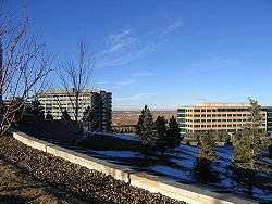
Economy
In the 1990s, Broomfield and other area suburbs experienced tremendous economic growth, much of it focused in technology.
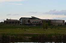
The Flatiron Crossing Mall is a large shopping and entertainment center, anchored by Nordstrom, Dick's Sporting Goods, Macy's, and Forever 21.
The Broomfield Enterprise is the local newspaper. KBDI-TV, the secondary PBS member station for the Denver area, is licensed to Broomfield.
Level 3 Communications, Ball, Vail Resorts, MWH Global, Webroot, Noodles & Company, WhiteWave Foods and Mrs. Fields are headquartered in Broomfield.
Top employers
According to Broomfield's 2011 Comprehensive Annual Financial Report,[21] the top employers in the city are:
| # | Employer | # of Employees |
|---|---|---|
| 1 | Level 3 Communications | 2,068 |
| 2 | Oracle | 1,900 |
| 3 | Urban Lending Solutions | 1,000 |
| 4 | Hunter Douglas | 805 |
| 5 | Staples | 700 |
| 6 | Ball | 648 |
| 7 | Sandoz | 600 |
| 8 | City and County of Broomfield | 581 |
| 9 | WhiteWave Foods | 450 |
| 10 | Vail Resorts | 430 |
| 11 | TransFirst | 385 |
| 12 | MWH Global | 350 |
| 13 | Brocade Communications Systems | 300 |
| 14 | VMware | 275 |
| 15 | Webroot | 275 |
| 16 | Zoll | 225 |
Recreation
Broomfield's recreation opportunities include the Paul Derda Recreation Center and pool, athletic fields, courts and rinks and open space and trails.[22][23]
Broomfield has an extensive trail system that connects the various lakes and parks. A scenic trail connects the Stearns Lake and the Josh's Pond on the west side of town. Broomfield also has a 9/11 memorial containing a piece of a steel beam from one of the towers.
Broomfield also has a skate park with many different features such as bowls, a large half pipe and several "street" obstacles.
Government
- Mayor - Randy Ahrens (term expires 2019)[24]
- Mayor Pro-Tem - Bette Erickson (term expires 2019)
- City & County Manager - Charles Ozaki
- City & County Attorney - Shaun T Sullivan
Council members
- Ward 1
- Stan Jezierski (term expires 2019)
- Elizabeth Law-Evans (term expires 2021)
- Ward 2
- Mike Shelton (term expires 2019)
- Sharon Tessier (term expires 2021)
- Ward 3
- Bette Erickson (term expires 2019)
- Deven Shaff (term expires 2021)
- Ward 4
- Kim Groom { term expires 2021}
- Kevin Kreeger (term expires 2019)
- Ward 5
- David Beacom (term expires 2019)
- Guyleen Castriotta (term expires 2021)
Education
Since Broomfield used to be divided among four counties, students living in the city were served by the separate school districts for their county. While the city is now united within one county, the city is still separated among multiple school districts.
There are five school districts that overlap Broomfield, but the two largest school districts in Broomfield are Adams Twelve Five Star Schools and Boulder Valley School District.
Broomfield features two large public high schools (Broomfield High School, which underwent significant renovations from 2009 to 2010, and Legacy High), two public middle schools and eight public elementary schools. There are three private schools: Broomfield Academy, with an academic preschool, an elementary school and a middle school; Holy Family, a Catholic high school; and Nativity of Our Lord Parish, a Catholic elementary school. Broomfield also contains two K-12 charter schools, Prospect Ridge Academy, and Front Range Academy, which has two Broomfield campuses.
Notable people
Notable individuals who were born in or have lived in Broomfield or both include:
- Mark Boslough, physicist[25]
- Drew Brown, musician, guitarist in the bands OneRepublic and Debate Team[26]
- Dianne Primavera (1950– ), Colorado state legislator[27]
- Anna Prins (1991– ), basketball center[28]
- Vince Russo (1961– ), pro wrestler[29]
- Steve Schmuhl (1993– ), swimmer[30]*
- Mike Wilpolt (1968– ), football wide receiver, defensive back, coach[31]
- Cat Zingano (1982– ), bantamweight MMA fighter[32]
See also
- Outline of Colorado
- Front Range Urban Corridor
- North Central Colorado Urban Area
- Denver-Aurora-Boulder, CO Combined Statistical Area
- Jefferson Parkway
- Northwest Parkway
- Rocky Flats National Wildlife Refuge
- 2013 Colorado floods
References
- "2014 U.S. Gazetteer Files: Places". United States Census Bureau. July 1, 2014. Retrieved January 5, 2015.
- "Colorado Municipal Incorporations". State of Colorado, Department of Personnel & Administration, Colorado State Archives. 2004-12-01. Retrieved 2007-09-02.
- "Active Colorado Municipalities". State of Colorado, Department of Local Affairs. Archived from the original on 2009-12-12. Retrieved 2007-09-01.
- "2016 U.S. Gazetteer Files". United States Census Bureau. Retrieved Jul 25, 2017.
- "City & County of Broomfield: Community". City & County of Broomfield. Archived from the original on 2007-09-27. Retrieved 2007-08-02.
- "State & County QuickFacts". United States Census Bureau. Retrieved June 7, 2014.
- "Population and Housing Unit Estimates". Retrieved July 18, 2019.
- "ZIP Code Lookup". United States Postal Service. Archived from the original (JavaScript/HTML) on September 3, 2007. Retrieved September 4, 2007.
- "Feature Detail Report for: Broomfield County". Geographic Names Information System. United States Geological Survey. Retrieved September 23, 2010.
- "Substantial Changes to Counties and County Equivalent Entities: 1970-Present". United States Census Bureau.
- "US Gazetteer files: 2010, 2000, and 1990". United States Census Bureau. 2011-02-12. Retrieved 2011-04-23.
- "City and County of Broomfield - Official Website - Demographics". broomfield.org. Retrieved 2 September 2015.
- "Colorado Population Density County Rank". Usa.com. Retrieved 27 August 2017.
- "USDA Interactive Plant Hardiness Map". United States Department of Agriculture. Retrieved 2019-07-11.
- "PRISM Climate Group, Oregon State University". www.prism.oregonstate.edu. Retrieved July 10, 2019.
- "U.S. Potential Natural Vegetation, Original Kuchler Types, v2.0 (Spatially Adjusted to Correct Geometric Distortions)". Data Basin. Retrieved 2019-07-11.
- "Census of Population and Housing". Census.gov. Archived from the original on April 26, 2015. Retrieved June 4, 2015.
- "Broomfield (city) QuickFacts from the US Census Bureau". census.gov. Archived from the original on 5 September 2015. Retrieved 2 September 2015.
- "Broomfield, Colorado". city-data.com. Retrieved 2 September 2015.
- "2015 Voter Registration Statistics". state.co.us. Retrieved 2 September 2015.
- City and County of Broomfield CAFR Archived January 23, 2013, at the Wayback Machine
- "Recreation and Senior Services | City and County of Broomfield - Official Website". www.broomfield.org. Retrieved 2019-04-26.
- "Open Space and Trails | City and County of Broomfield - Official Website". www.broomfield.org. Retrieved 2019-04-26.
- "City and County of Broomfield - Official Website - Mayor Randy Ahrens". Ci.broomfield.co.us. Retrieved 2016-03-05.
- Boslough, Mark (2014-11-30). "F-Bomb the N-Word Out of Existence". Huffington Post. Retrieved 2016-05-02.
- "Brown comes home to Broomfield for Broomstock". Retrieved 2018-03-10.
- "Dianne Primavera's Biography". Vote Smart. Retrieved 2016-05-02.
- "Anna Prins". Iowa State Cyclones. Retrieved 2016-05-02.
- "Rope Opera: How WCW Killed Vince Russo". Amazon. Retrieved 2016-05-02.
- "Steve Schmuhl". Indiana University Athletics. Retrieved 2016-05-02.
- "Mike Wilpolt". ArenaFan. Retrieved 2016-05-02.
- "Cat Zingano". UFC. Retrieved 2016-05-02.
External links
| Wikimedia Commons has media related to Broomfield, Colorado. |
- City and County of Broomfield website
- CDOT map of the City and County of Broomfield
- Colorado Historical Society
Places adjacent to Broomfield, Colorado | ||||||||||
|---|---|---|---|---|---|---|---|---|---|---|
| ||||||||||
Denver (capital) | ||
| Topics |
|  Seal of Colorado |
| Society |
| |
| Regions |
| |
| Municipalities |
| |
| Counties |
| |
| Authority control |
|
|---|